Download presentation
Presentation is loading. Please wait.

1
Brainstorming Session on Meteorological Services for Improved Humanitarian Emergency Contingency Planning and Response UNITAR Operational Satellite Applications Programme (UNOSAT) Delivered by Oliver van Dame 01 Sep 2010
 Delivered by Oliver van Dame 01 Sep 2010")
2
2 Introduction to UNITAR What is UNITAR? United Nations Institute for Training and Research Mission: To deliver innovative training and conduct research on knowledge systems to develop the capacity of beneficiaries Since its inception in 1965, UNITAR has built sustainable partnerships acquiring unique expertise and accumulating experience and knowledge to fulfil its mandate. These accomplishments have enabled UNITAR to respond to the growing demand from UN Member States for training for capacity development in the fields of Environment; Peace, Security and Diplomacy; and Governance Offices: Geneva (HQ), New York, Hiroshima, (Brazil)
, New York, Hiroshima, (Brazil).")
3
3 Introduction to UNOSAT What is UNOSAT? The United Nations Institute for Training and Research (UNITAR) Operational Satellite Applications Programme - a unique UN programme entirely dedicated to providing satellite based solutions to the UN, local governments, international organizations and NGOs Has evolved into a mature UN service with global outreach and supported by a network of partners world wide Diversifying the offer of satellite & IT based services and adapt it to specific user needs of the international community UNOSAT works always upon request of at least one major organization directly or indirectly involved in operations and validated by relevant UN coordination mechanisms Received UN21 Awards from Secretary General Kofi Annan in December 2006 in recognition of team productivity and contribution to a more efficient and modern United Nations
 Operational Satellite Applications Programme - a unique UN programme entirely dedicated to providing satellite based solutions to the UN, local governments, international organizations and NGOs Has evolved into a mature UN service with global outreach and supported by a network of partners world wide Diversifying the offer of satellite & IT based services and adapt it to specific user needs of the international community UNOSAT works always upon request of at least one major organization directly or indirectly involved in operations and validated by relevant UN coordination mechanisms Received UN21 Awards from Secretary General Kofi Annan in December 2006 in recognition of team productivity and contribution to a more efficient and modern United Nations.")
4
4 Introduction to UNOSAT Three main pillars Humanitarian Emergencies and Human Rights - UNOSAT Rapid Mapping Training on satellite solutions and GIS - customized, from user-perspective Capacity development – longer term projects providing benefits of satellite solutions to local governments

5
UNITAR/UNOSAT – WMO: Memorandum of Understanding (MoU)
")
6
6 Disaster management cycle

7
7 UNOSAT integrated response model for humanitarian emergencies, contingency planning and development Demand for geo-information

8
Operational procedures GDACS alerts Additional information collection on event Liaise with UN sister agencies Trigger UNOSAT Rapid Mapping (2/3 public, commercial, bilaterally provided data, 1/3 International Charter Space and Major Disasters – UNOSAT can trigger Space Charter directly for OCHA and other UN) Produce first map/analysis asap (1-2 days). In parallel collect complementary information, including hydro-meteorological Produce disaster specific maps/analyses (1-7 days, depending on imagery availability) Feedback, review
 Feedback, review.")
9
Current sources and mechanisms to access hydro-met information Rainfall data: NASA, TRMM Forecasts: ECMWF through WMO, media Digital Elevation Models (hydro networks): SRTM, ASTER 30 m UNEP Climate Data
: SRTM, ASTER 30 m UNEP Climate Data")
10
10 Introduction to UNOSAT Statistics: UNOSAT Humanitarian Rapid Mapping, 2003-2009 (150+ events) Direct hydro-met event, services needed Complementary hydro-met services needed
 Direct hydro-met event, services needed Complementary hydro-met services needed")
11
11 Distribution of results Satellite imagery derived information as GIS-ready information layers, final maps and analyses to wide range of users in the field, regional offices, HQ (geographically distributed) Results distributed to wide range of types of users (UN, IFRC, ICRC, NGOs, Governments etc.) with different mandates (thematically distributed) Means of distribution: VirtualOSOCC/GDACS, HICs, GeoNetwork, ReliefWeb, GeoRSS feeds, UNOSAT website, AlertNet, e-mail alerts, other – Online mapping once operational
 Results distributed to wide range of types of users (UN, IFRC, ICRC, NGOs, Governments etc.) with different mandates (thematically distributed) Means of distribution: VirtualOSOCC/GDACS, HICs, GeoNetwork, ReliefWeb, GeoRSS feeds, UNOSAT website, AlertNet, alerts, other – Online mapping once operational")
12
Examples

13
Floods

17
17

19
19 Mozambique: Observed flooding from satellite vs. modeled flood exposed areas

20
TRMM rainfall data

24
Fires

25
25

26
Earthquakes

28
28 Feb, Mar, Apr: Max temperature (daytime) Min temperature (nighttime) Max snow cover
 Min temperature (nighttime) Max snow cover")
29
Storms

31
Landslides

33
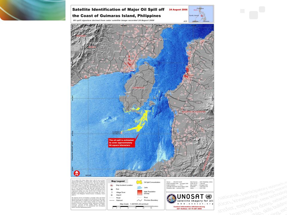
Oil spills

35
Technical/chemical

36
36

37
Meteorological and hydrological information needs Detailed meteorological forecasts services needed globally (based on lat/lon, not just main towns) Precipitation Temperature Wind (direction, strength) Snow depth Climate data & models (monthly averages, min/max) Flood models Detailed elevation data for deriving hydro-networks (SRTM, GEO review of ASTER 30 m in collaboration with Swisstopo) Build on good experience WMO-ECMWF-UNOSAT
 Precipitation Temperature Wind (direction, strength) Snow depth Climate data & models (monthly averages, min/max) Flood models Detailed elevation data for deriving hydro-networks (SRTM, GEO review of ASTER 30 m in collaboration with Swisstopo) Build on good experience WMO-ECMWF-UNOSAT")
38
www.unitar.org/unosat einar.bjorgo@unitar.org

Similar presentations


>")


 Task.>")
 Task Team on the Provision of Operational.>")


 December 2013, GEONETCast Virtual.>")
 (Hyderabad, India, 25.>")
 Adaptation Knowledge Day V: Climate Change Adaptation Gaps BONN,>")


