Download presentation
Presentation is loading. Please wait.

1
Geography of Canada Mr. Hartley Geography & Technology

2
1.Geographic Information Systems 2.Global Positioning System 3.Aerial Photographs 4.Satellite Imagery

3
Geographic Information Systems Geographic Information Systems (GIS) is a technology that manages, analyzes, and displays geographic data. Essentially, GIS is maps on computers. Each characteristic of the Earth’s surface is mapped on a layer which can be viewed independently, or in combination with other layers.

4
Geographic Information Systems

5
GIS can analyze data in many ways: Geographic Information Systems

6
Attribute Information: What is it? Species: Oak Height: 15m Age: 75 Yrs Location Information: Where is it? 51°N, 112°W Source: ESRI Canada, WhatsGIS.ppt GIS – Locations and Attributes

7
GIS software links the location data and the attribute data: Source: ESRI Canada, What’s GIS.ppt GIS – Locations and Attributes

8
GIS software can answer questions about our world: What provinces border Saskatchewan? Spatial Questions: What provinces have more than 1.5 million people? Attribute Questions: Source: ESRI Canada, What’s GIS.ppt GIS – Asking Questions

9
GIS – Why Use It? Support for decision-making based on spatial data: Visual representation of data Maintenance, manipulation of data Analyze information of geographic areas Produce customized cartographic products

10
Is it safe to dig here? A proposed excavation, identified by address, is compared to pipelines in the area using Geotechnology. Source: ESRI Canada, What’s GIS.ppt GIS – Real World Uses

11
What is the fastest route to the Hospital? Geotechnology can choose the fastest route to a hospital. The GIS can take into account traffic and other impediments. Source: ESRI Canada, What’s GIS.ppt GIS – Real World Uses

12
Global Positioning System The GPS (Global Positioning System) is a "constellation" of 24 well-spaced satellites that orbit the Earth and make it possible for people with ground receivers to pinpoint their location. The location accuracy is anywhere from 50 to 1 metres for most equipment. In the 1990s, accuracy could be pinpointed to within one metre with special military-approved equipment. Today that is true on most cellular devices.

13
How does it work? The GPS receiver calculates position by timing the signals sent by the satellites high above the Earth. These devices are used in military, aviation, marine, and consumer products. Most devices are mobile; the early ones did not display maps.

14
Global Positioning System

15
A hand-held GPS unit

16
Global Positioning System An in-dash GPS unit

17
Aerial Photographs Using the photographs of the Earth taken by airplanes, you can see the world in 3D using a stereoscope.

18
Aerial Photographs Google Earth is a computer program (that you can download for free!) that shows aerial photographs in a digital format, with a general purpose map on top. www.earth.google.com
19
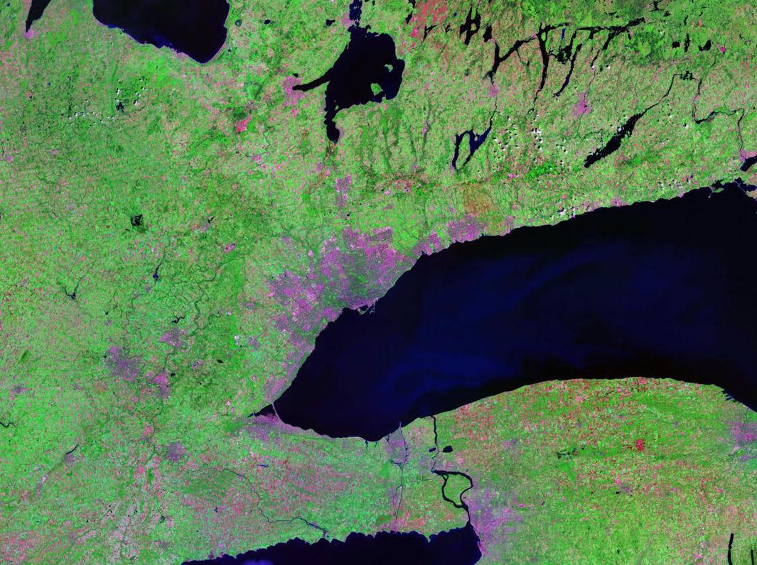
Satellite Imagery Satellite images are also pictures of the Earth taken from high above, but these electronic images (instead of photographs) cover very large areas but show less detail. –Landsat (American) and uses sunlight and heat reflected from the Earth’s surface to create images –SPOT (European) and similar to Landsat, but it can create 3D images of the surface. –RADARSAT (Canadian) and uses radar signals (or microwaves) instead of sunlight and heat, so it can be used at any time of day or night.
 and uses sunlight and heat reflected from the Earth’s surface to create images –SPOT (European) and similar to Landsat, but it can create 3D images of the surface. –RADARSAT (Canadian) and uses radar signals (or microwaves) instead of sunlight and heat, so it can be used at any time of day or night..")
20
Landsat Program Landsat 7 was launched on April 15, 1999. Providing up to date and cloud free images. It was designed to last 10 years, and has the capacity to collect 500+ pictures per day Used for global change research and applications in agriculture, cartography, forestry, regional planning, etc.

21
Landsat

22
SPOT Satellite Pour l'Observation de la Terre is based out of France. Designed to improve knowledge and management of the earth as well as human activities. SPOT offers a higher resolution than most other satellites. (2.5 to 5m)
.")
23
SPOT

24
RADARSAT The first, RADARSAT-1 was launched in 1995. Created in Canada to provide earth observation data worldwide. Sends radar (microwave) signals to earth and then records them when reflected back.
 signals to earth and then records them when reflected back..")
25
RADARSAT

Similar presentations


 Geography is the study of locational and spatial trends about the earth’s surface, the objects found on it, and the.>")


 by JOHANNES VERMEER>")


