Download presentation
Presentation is loading. Please wait.

1
Intro to GIS | Summer 2012 Attribute Tables – Part 1

2
DATABASES

3
Why do we care about Databases? Integrated sets of data Focused on a particular area and subject Form the basis of GIS analysis and decision-making Must be well-structured in order for us to best access the information stored in them

4
How are Databases Managed? Database Management System (DBMS) = system or software program(s) that enables you to store, modify and extract information from a database
 = system or software program(s) that enables you to store, modify and extract information from a database.")
5
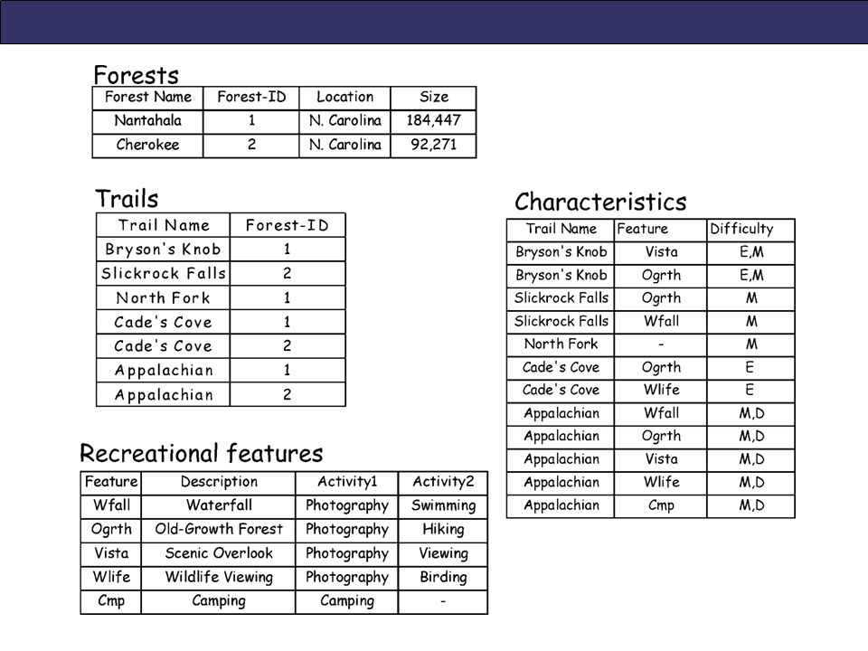
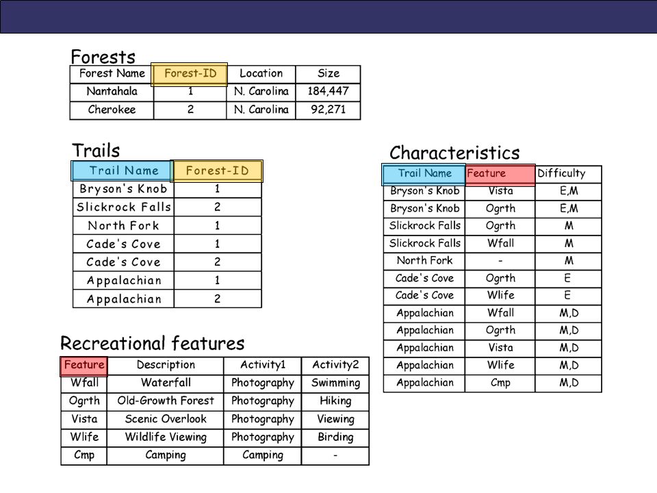
Relational Database (RDBMS) Supports the representation of data as a set of tables that are related to each other Each table = a list of records containing attributes about features Tied together by a “Attribute Key” = an attribute field common to both tables
 Supports the representation of data as a set of tables that are related to each other Each table = a list of records containing attributes about features Tied together by a Attribute Key = an attribute field common to both tables")
6
Record: a row in a database; represents one feature (a.k.a. “tuple”) Attribute: a column in a database; contains attribute values (a.k.a. “field”) Table Data Structure
 Attribute: a column in a database; contains attribute values (a.k.a. field ) Table Data Structure.")
8
Which attribute field is the Attribute Key in this case?

10
Object (ODBMS) & Object-Relational (ORDBMS) Databases ODBMS = Supports the representation of data as objects having attributes, methods and behavior e.g. ArcGIS geodatabases Designed to address the weaknesses of RDBMS such as: Geometry and attribute data are stored in separate databases Poor performance for many types of geographic query Geographic extensions to standard RDBMS can provide similar functionality (ORDBMS)
.")
11
GEOGRAPHIC (SPATIAL) DATABASES
 DATABASES")
12
What is a Geographic (Spatial) Database? Contains one or more tables with a geographic component (a “shape” attribute) Common example: an ESRI Geodatabase
 Common example: an ESRI Geodatabase.")
13
ESRI Geodatabase Features have: Shapes Attributes Spatial Reference Relationships Features can be: Constrained (domains) Validated by rules Modeled with complex behavior
 Validated by rules Modeled with complex behavior")
14
ESRI Geodatabase

15
Types of Geodatabases Personal Single-user Microsoft Access Up to 2 GB storage File Single-user File folder structure Up to 1 TB storage ArcSDE Multi-User, supports versioning Oracle, Microsoft SQL Server, IBM DB2, IBM Informix, PostgreSQL Storage limit based on DBMS type ESRI Comparison of Geodatabases

16
“Default” Geodatabase A setting in ArcGIS Helps with data management Allows you to: Store all datasets in one convenient location, or Set a database for each project

17
Setting the Default Geodatabase - ArcMap

18
Change location of Default Geodatabase

19
Setting the Default Geodatabase – ArcCatalog

20
QUERYING GIS DATA

21
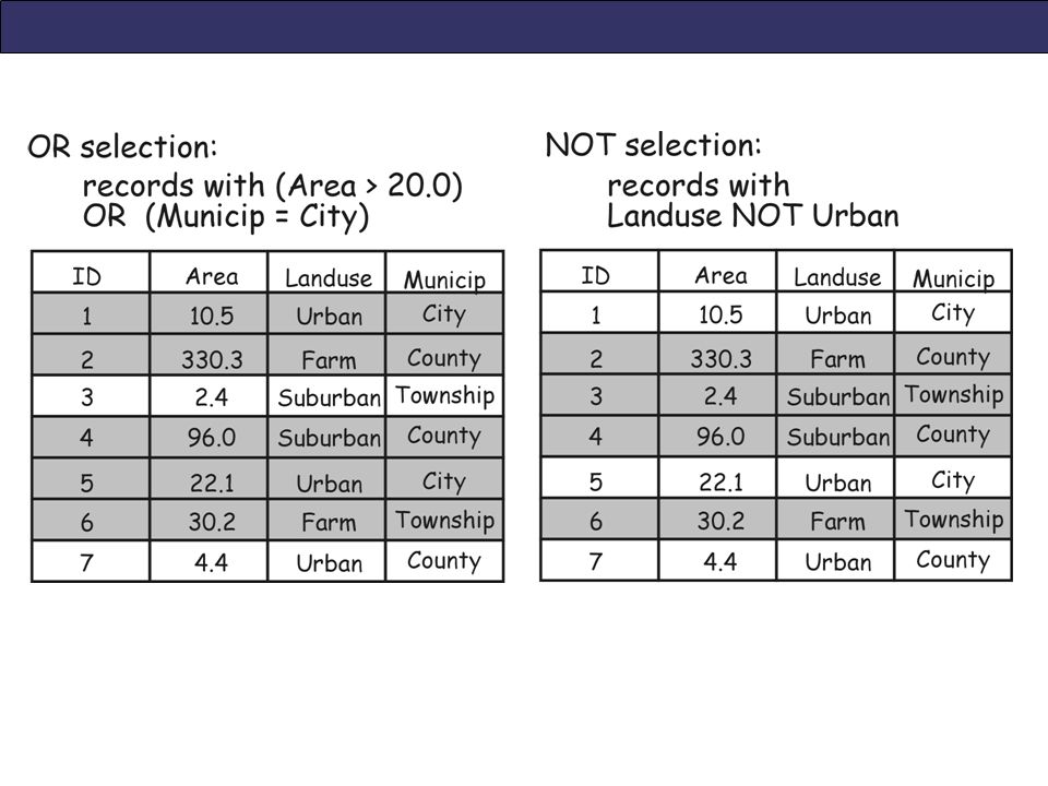
Getting Information from GIS data Query = to question or inquire about a feature(s) shown on a map (and by extension, in a GIS dataset) Output is a selected set of records Two approaches: Attribute queries Spatial queries
 shown on a map (and by extension, in a GIS dataset) Output is a selected set of records Two approaches: Attribute queries Spatial queries")
22
Attribute Queries Selects features based on non-spatial information in an attribute table e.g. Which counties in the US have > 100,000 people? “Select By Attributes” tool in ArcMap SQL (structured query language) used to write query
 used to write query.")
25
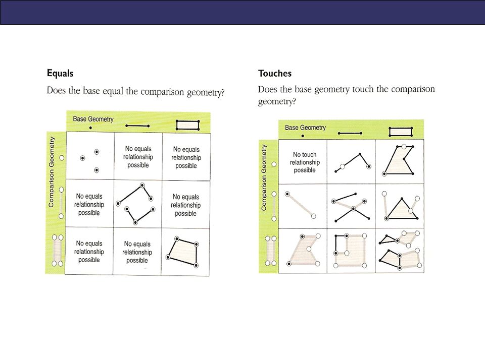
Spatial Queries Selects features based on location or spatial relationship between data layers e.g. Which Oregon counties have an interstate highway passing through them? “Select Layer by Location” tool in ArcMap Target layer = base layer; contains features you want selected Filter layer = comparison layer What kind of spatial relationships are possible between points, lines and polygons?

28
“Add XY Data” tool

29
Bakery list – Excel file

30
New Point Layer for Bakery Locations

Similar presentations


 >")


