Download presentation
Presentation is loading. Please wait.

1
Flooding Chapter 6

2
Learning Objectives Understand basic river processes
Understand the process of flooding and the difference between flash floods and downstream floods Know what geographic regions are at risk from flooding Know the effects of flooding and the linkages with other natural hazards Recognize the benefits of periodic flooding Understand how people interact with and affect the flood hazard Be familiar with adjustments we can make to minimize flood deaths and damage

3
Mississippi River Floods and Controls
The Mississippi River is notorious for flooding anytime from June to August To help control theses flood waters, levees and dams have been built up and down the river and its tributaries Problems happen when in years of high waters, these controls are often breached When this happens neighborhoods are flooded and people are killed. Lesson learned construction of levees and dams provides a false sense of security

5
Introduction to Rivers
The study of Stream and River systems or cycles is called hydrology The hydrologic cycle is where water evaporates from the Earth’s surface, primarily from the ocean, into the atmosphere, where it forms clouds and precipitation, which returns to the Earth as rain and/snow, to run down streams or rivers to lakes and into the ground where it is absorbed by plants and soil to be evaporated back into the air by evapotranspiration to start forming clouds again. (REMEMBER THIS)
")
7
Hydrologic Systems Two types of running water
Overland flow -- Movement of surface water over and outside its channel Stream flow – channeled movement of water along a valley bottom Two topographic elements for stream systems Valley -- that portion of the terrain in which a drainage system is clearly established. Ridge– the higher land above the valley sides that separates adjacent valleys.

8
Earth Material Transported by Rivers
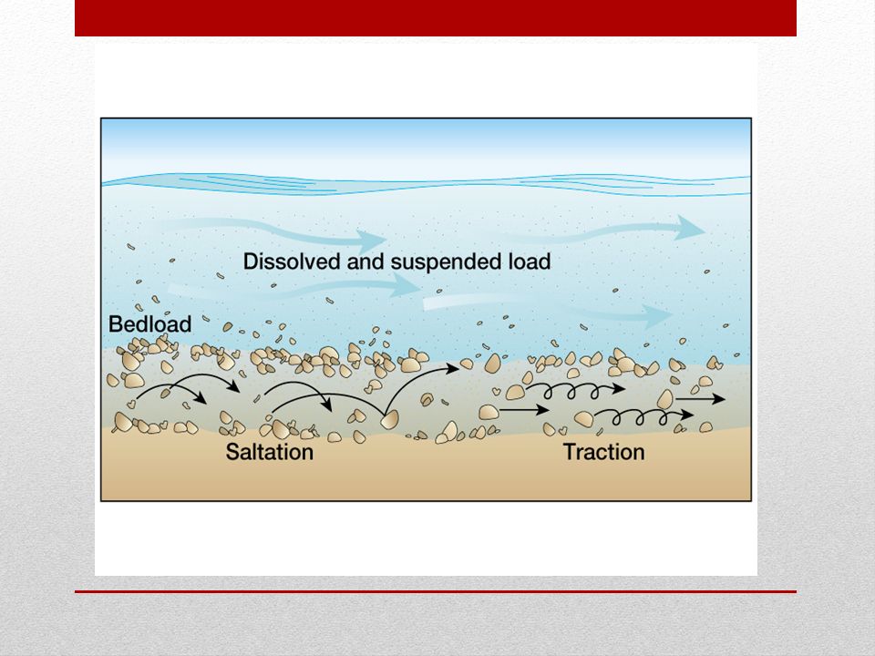
Any water moving down slope, whether moving as overland flow or as stream flow, can transport rock material Stream load – the mass of material that reaches the stream bottom plus the stream-eroded debris. Stream load can contain: Dissolved load -- some minerals, mostly salts dissolved in the water and carried in solution Suspended load– fine particles of clay and silt carried suspended in the water without ever touching the streambed. Bedload – sand, gravel, and larger rock fragments found on the bottom of the stream. Small particles bouncing along are called saltation. Coarser pieces move by traction.

10
River Velocity Rivers are basic transportation systems of the rock cycle They are the agents of erosion and deposition of sediment They are the primary agent in the sculpture of our landscape The velocity of the water in the river varies along its course effecting both erosion and deposition of sediment

11
Discharge and Erosion by a River
Discharge is the volume of water moving through a cross section of river per unit of time Erosion is accomplished in part by the direct hydraulic power or velocity of the moving water through the section of time. Erosive capability is enhanced by the abrasive tools a river picks up and carries along with it. Some chemical weathering processes called “corrosion” help to erode Erosive effectiveness of the river flow varies enormously, depending on the speed and turbulence of the flow on one hand and the resistance of the bedrock on the other hand

12
How Erosion Changes the Landscape
Base level – the lowest level or limit a stream will down cut a valley- the imaginary surface extending underneath the continents from sea level at the coast Valley Deeping – Stream expends most energy in down cutting Graded Stream – a stream which the gradient just allows the stream to transport its load

13
Deposition Whatever is picked up must eventually be set down, which means that erosion is inevitably followed by deposition. Alluvium – general term for stream-deposited debris, characterized by a sorting of particles on the basis of size.

14
Deposition from Rivers
Debris -- transported some distance, dropped, and then picked up later and carried farther Competence-- a measure of the particle size a stream can transport, expressed by the largest particles that can be moved. Capacity – a measure of the amount of solid material a stream has the potential to transport, normally expressed as the volume of material passing a given point in the stream channel during a given time interval.

15
Deposition in Valleys Stream flow expands and slows down as the river leaves the mountains onto the plains or from a channel into an ocean, lake, or pond At this point the river forms a fan like deposit known as an alluvial fan In larger bodies of water, the river creates a delta Rivers entering an alluvial fan or delta often split into a system of distributary channels These channels may change position rapidly during a single flood or from one flood to another

16
Alluvial Fan Delta

17
Fluvial Erosion and Deposition
Erosion by Overland Flow Begins when rain starts to fall Without vegetation or some other protective covering the collisions with the ground is strong enough to blast fine soil particles upward and outward shifting them a few millimeters downhill by the “splash erosion” In the first few minutes much of the rain infiltrates the soil and the “runoff” starts. If a heavy rain continues and the land is sloping the water moves down slope as overflow

18
Fluvial Erosion and Deposition
Sheet erosion – as water flows across the surface as a thin sheet, transporting material already loosened by splash erosion Rills – tiny channels of overland flow as it moves down slope and its volume increases and turbulence causing “rill erosion” Gullies and gully erosion – as rills grow in size forming gullies which cause gully erosion

19
River Channels Channel Flow – confined to channels (different from overland flow) Three-dimensional nature with considerable complexity Movement in the channel, unsystematic and irregular Principal cause of flow irregularity is retarding effect of friction along the bottom and sides of the channel. Turbulence- general downstream movement interrupted by irregularities in the direction and speed of the water. Caused partly by friction, partly by internal shearing stresses between currents with the flow, and partly by surface irregularities in the channel. Effect of turbulence is varied because it is selective process.

20
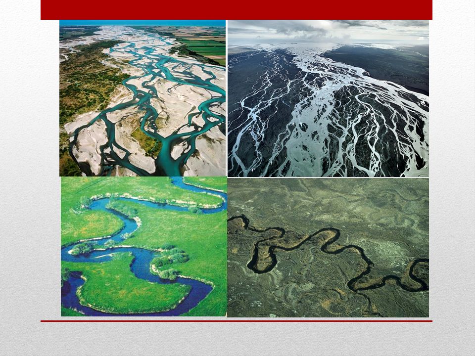
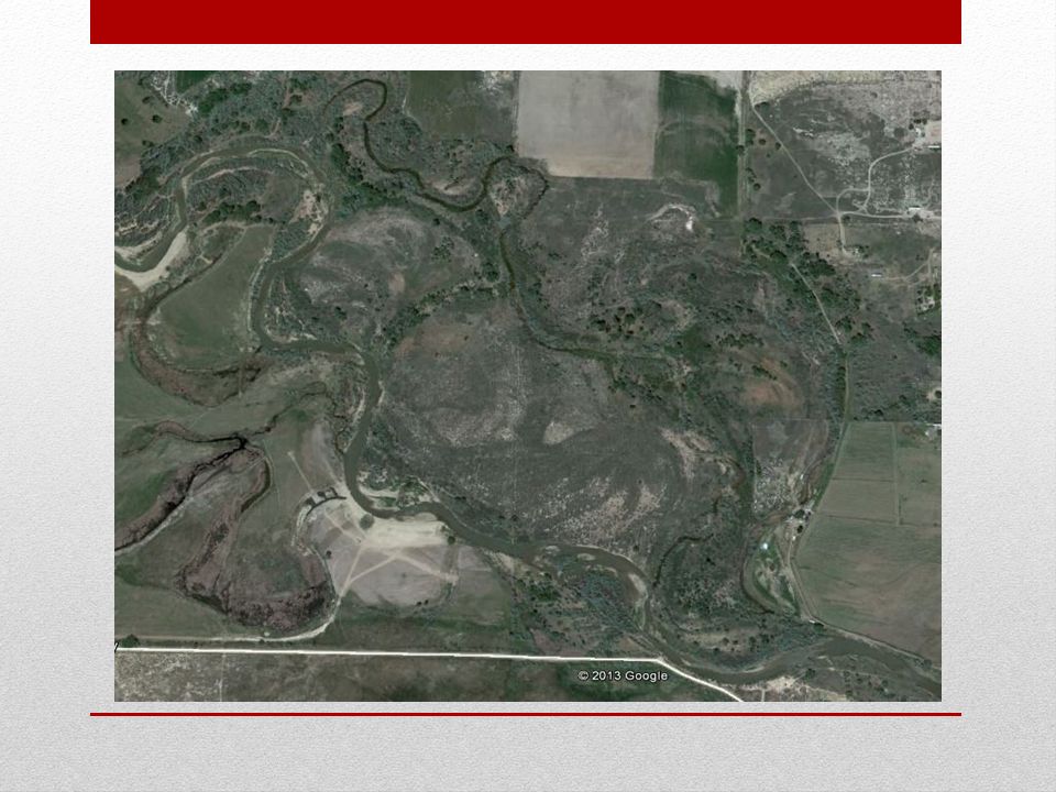
Channel Patterns Channel patterns are the result from the interaction of flowing water and moving sediment accumulation and the river itself There are two common channels Braided channels –a multiplicity of inter-woven and interconnected channels separated by low bars or islands of sand, gravel, and other loose debris Wide, shallow rivers with numerous sand and gravel bars and islands Meandering channels – extraordinarily intricate pattern of smooth curves in which the stream follow a serpentine course, the land is usually flat Curves that go back and forth across the floodplain over a period of years to decades

22
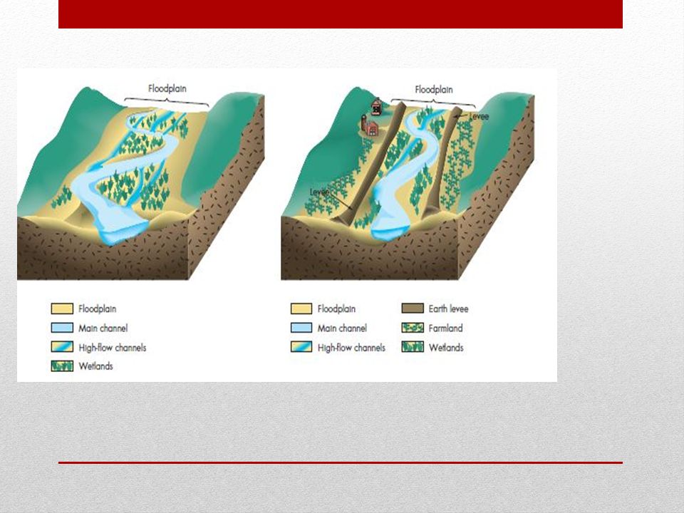
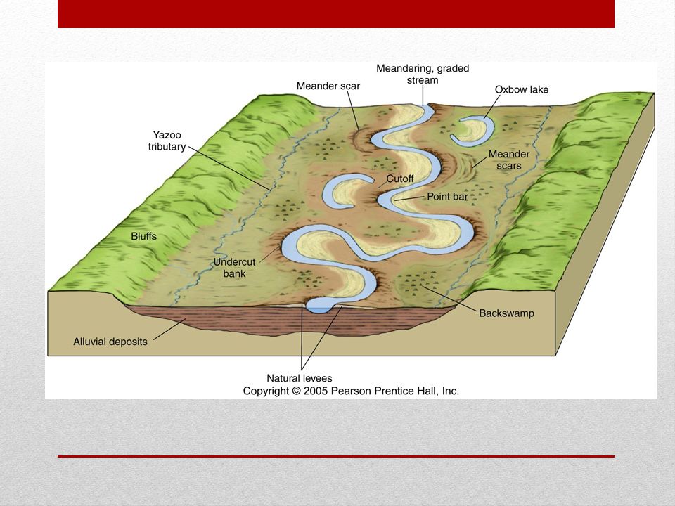
Floodplain Formations
A low lying, nearly flat alluvial valley floor that is periodically inundated with flood waters. Often formed where a meandering stream flows across a wide nearly level valley floor Landforms of a meandering stream Cutbank – Fast moving water erodes the riverbank on the outside of the bend to form a steep or near vertical slope Point Bar – Sand and gravel deposited on the inside of a river bend by slower water This process of continual erosion or the cutbank and the deposition of the point bar helps in the construction of the floodplain

23
Floodplain Formation Floodplain Landforms
Bluffs – outer limit of lateral erosion and undercutting where the flat terrain abruptly changes to a line Cutoff meander – a loop is short-circuited as a stream cuts a new channel across its neck and starts meandering again – leaving the old meander loop Oxbow lake – the old meander loop Oxbow swamp – the oxbow lake as it fills with vegetation Meander scars – as vegetation grows over the cutoff meanders and oxbow lakes leaving only scars

26
Flooding The natural process of over bank flow is termed flooding
Most river flooding is related To the amount and distribution of precipitation in a drainage basin The rate at which the precipitation soaks into the ground How quickly surface runoff from the precipitation reaches the river The amount of moisture in the soil at the time the precipitation start

27
Characteristics of a Flood
Flooding is when the discharge of the stream is at the point where water overflows the channel banks Flood stage is the stage or height of water when the river begins to flood These stages are shown on a hydrograph The term flood stage is derived from The elevation of the water surface as it reaches a level likely to cause damage to personal property This elevation depends on human use on the floodplain A recurrence interval of a flood is the average time between flood events that are of equal or greater magnitude

28
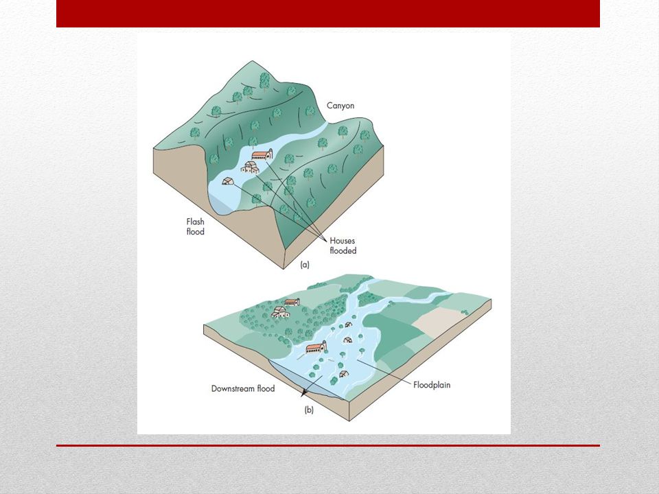
Flash Floods and Downstream Floods
Floods can further be characterized by where they occur in a drainage basin Flash Floods – occur in the upper part of a drainage basin and in some small drainage basins of tributaries to larger rivers Produced by intense rainfall of short duration over a relatively small area Sudden and of relatively great volume, peak discharge, sometimes in less than 10 minutes Common in arid and semiarid environments; in areas with steep topography or little vegetation; and following breaks of dames, levees, and ice jams Locally don’t cause flooding, but in combination with larger streams downstream where they cause a great deal of damage Downstream floods -- cover a wide area and are usually produced by storms of long duration that saturate the soil and produce increased runoff. Characterized by the downstream movement of floodwaters with a large rise and fall of discharge at a particular location

30
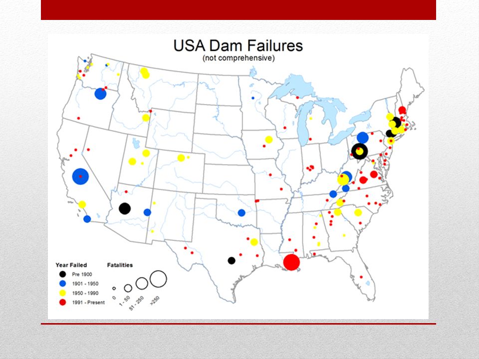
Geographic Regions at Risk for Flooding
Any place in the United States, floods are the number-one disaster during the 21st Century An average of 100 lives were lost each year from river flooding Flooding is one of the most universally experienced natural hazards Virtually all areas of the United States and Canada are vulnerable to floods and any place around the world for that matter

31
Effects of Flooding and Linkages Between Floods and other Hazards
Effects of floods are primarily linked to: Injury Loss of life Damage caused by swift currents, debris and sediment to farms, homes, buildings, railroads, bridges, roads, and communication systems Deposition of sediment causing the loss of soil and vegetation Several factors which affect the damage caused by floods are: Land use on the floodplain Depth and velocity of floodwaters Rate of rise and duration of flooding Season of the year in which flooding takes place Quantity and type of sediment transported and deposited by floodwaters Effectiveness of forecasting, warning, and evacuation

32
Natural Service Functions of Flooding
Although flooding can be a hazard, it is naturally no more than overbank flow This overbank flow “flooding” is only a hazard when people live or build structures on the floodplain or try to cross a flooding river There are benefits to periodic flooding Fertile lands – the deposit of fine sand, silt, clay, and organic material is deposited as floodwaters slow over the farmland Aquatic Ecosystems – during floods debris such as boulders, logs, and tree branches are flushed out streams channels Sediment Supply – flooding can increase the elevation of landmass

33
Human Interaction with Flooding
Unlike with other natural hazards, human activity can significantly affect river processes, including the magnitude and frequency of flooding These activities can include: Land-use: streams and rivers are open systems that maintain a rough dynamic equilibrium The increase or decrease in the amount of water or sediment received by a stream usually brings changes to its gradient or cross-sectional shape This changes the stream’s sediment or water volume may set into motion a series of events that result in a new dynamic equilibrium Dam Construction: damming a stream or river makes considerable changes upstream and downstream Upstream: the water enters a reservoir, slows down deposits sediment and may form a delta Downstream: the water coming out below the dam will have little sediment allowing the stream to transport more sediment, so less deposition happens. The equilibrium is different, causing the slope of the stream to change

34
Human Interaction with Flooding
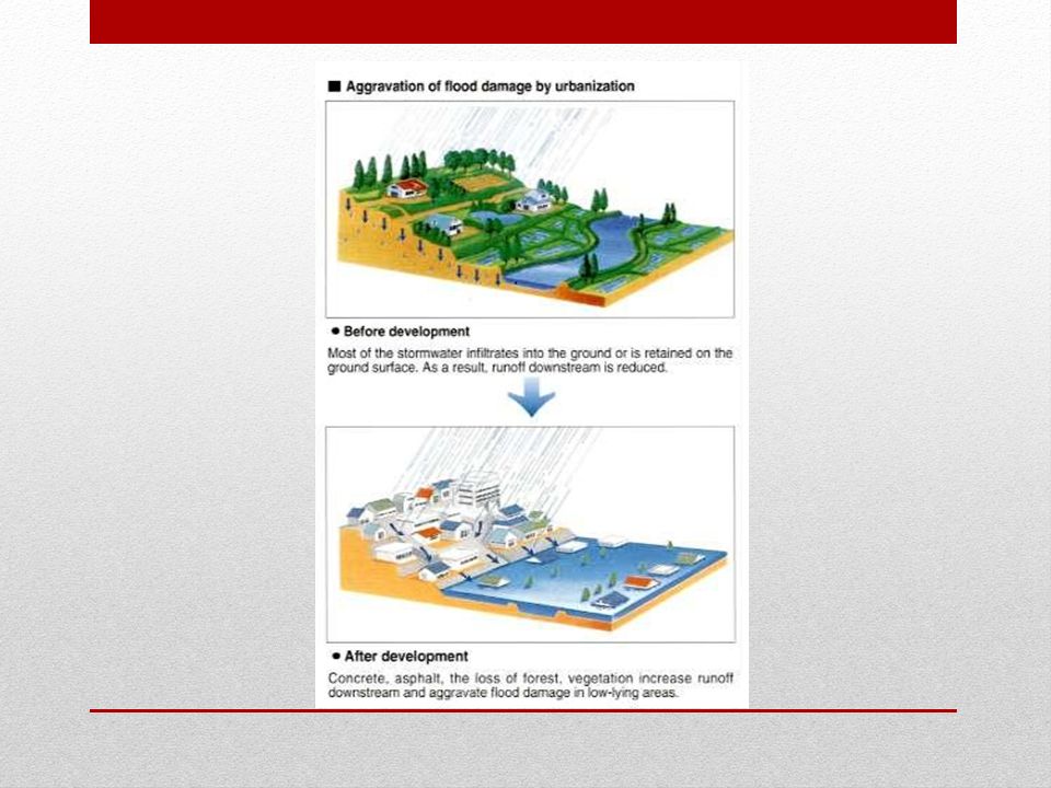
Urbanization and Flooding: Human activities increase both the magnitude and frequency of floods in small urban drainage basins The rate of increase is determined by the amount of land covered with roofs, pavement and cement (or impervious cover) and the area served by storm sewers Floods are a function of the relationship between rainfall and runoff, which is significantly changed by urbanization Besides increasing runoff and flooding frequency, urbanization affects how rapidly floods develop Before urbanization there as a considerable delay or lag time between a heavy rain and flooding. After urbanization this delay is shortened considerably. This is called a flash discharge. The fine sediment found in the flooding can clog the sewer systems, causing more flooding In poor countries, where there is a high density of population living in substandard housing, flooding moves from a disaster to a catastrophe.
 and the area served by storm sewers. Floods are a function of the relationship between rainfall and runoff, which is significantly changed by urbanization. Besides increasing runoff and flooding frequency, urbanization affects how rapidly floods develop. Before urbanization there as a considerable delay or lag time between a heavy rain and flooding. After urbanization this delay is shortened considerably. This is called a flash discharge. The fine sediment found in the flooding can clog the sewer systems, causing more flooding. In poor countries, where there is a high density of population living in substandard housing, flooding moves from a disaster to a catastrophe.")
36
Grand Canyon Experiment

37
Minimizing the Flood Hazard
Historically humans have responded to floods by attempting to prevent them by modifying the streams and rivers This has been done by two approaches, structural or channel reshaping Creating physical barriers, such as dams and levees Widening, deepening or straightening the channel

38
Minimizing the Flood Hazard
Physical Barriers to prevent flooding physical barriers have been built across the nation. These include: Earthen levees Concrete flood walls Reservoirs to store water for later release at safe rates Storm water retention basins Often the benefits of these barriers are lost because of the increased development on the floodplain they were designed to protect These barriers are also inadequate because they are often old and in poor condition. During a flood, they can break, causing more damage Most dams and levees are on private land and are not maintained creating a bigger hazard than if they weren’t there

39
Minimizing the Flood Hazard
Flood control on the Mississippi and its delta

41
Minimizing the Flood Hazard
Channelization: Straightening, deepening, widening, clearing, and/or lining existing stream channels The objective of this is control floods and erosion, drain wetlands, and improve navigation Opponents of modifying natural streams is opposite to the production of fish and wetland wildlife and causes extensive aesthetic degradation. Their argument is: Drainage of wetlands adversely affects plants and animals Cutting trees eliminates shading and cover for fish Cutting floodplain hardwood trees eliminates habitats for birds and animals Straightening and modifying the streambed destroys the feeding and breeding areas of aquatic life Conversion of wetlands from a meandering stream seriously degrades the value of the natural area Not all channelization causes serious environmental degradation. This would be found in urban areas subject to flooding and rural areas where flooding has happened

42
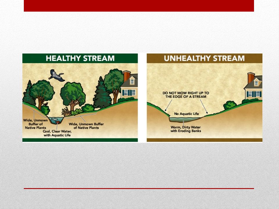
Channel Restoration: Alternative to Channelization
In many urban areas streams barely resemble a natural channel Channel Restoration allows the stream to meander and where possible allowing a more natural flow of water The techniques of channel restoration are: Cleaning urban waste from the channel allowing the stream to flow freely Protecting the existing channel banks by not removing existing trees Where necessary plant more native trees and other vegetation Trees are important because they provide shade for the stream inhabitants and their roots secure the stream banks

44
Perception of and Adjustment to the Flood Hazard
Perception of the Flood Hazards Government agencies, planners, and policy makers are aware of flood hazards But the public is not aware, or choose to not pay attention There are flood maps available, but houses and buildings are still built in these areas Dams and levees are built to help relieve the chances of floods, but they are not always kept in the best of repair The Federal Government has encouraged state and local governments to adopt floodplain management plans, but these plans are hard to enforce Increased awareness in flood danger and management would help in flash floods, but this would probably not stop people from driving their cars into flooded streets and getting killed (you know the saying)
")
45
Perception of and Adjustment to the Flood Hazard
Adjustments to the Flood Hazards In recent decades, we have begun to recognize the advantages of alternatives to structural flood control These alternatives include: Flood Insurance: The National Flood Insurance Program New homeowners in flood hazard areas must buy flood insurance Flood-Proofing-Several methods of flood-proofing are currently available Raising the foundation of a building above the flood-hazard level using piles or columns Constructing flood walls or earthen mounds around buildings to isolate them from floodwaters Using waterproofing construction Installing improved drains with pumps to remove incoming floodwater Floodplain Regulation: obtain the most beneficial use of floodplains while minimizing flood damage and cost of flood protection

46
Relocating People from Floodplains
For several years, local, state, and federal governments have been selectively purchasing and removing homes damaged by floodwaters to reduce future losses Example from North Dakota and North Carolina In North Carolina, flooding damage 700 homes in Rocky Mount. After a huge flood in 1999, the federal government decided to buy 430 of the 700 houses damaged by flooding. These homes were demolished, thus decreasing the chance of future flood damage in that area In Churchs Ferry, North Dakota, in 1993, the nearby lake began to grow from too much rain or snow. By 2000, there were only 7 people left in the town. Most of the people took advantage of a federal buy out to move to higher ground. Of the 7 left, they were very happy with the government.

47
Personal Adjustment: What to do and What Not to Do
Prepare for the flood What to do What not to do Learn what to do when a flood warning is issued After a Flood KNOW THIS!!!

Similar presentations
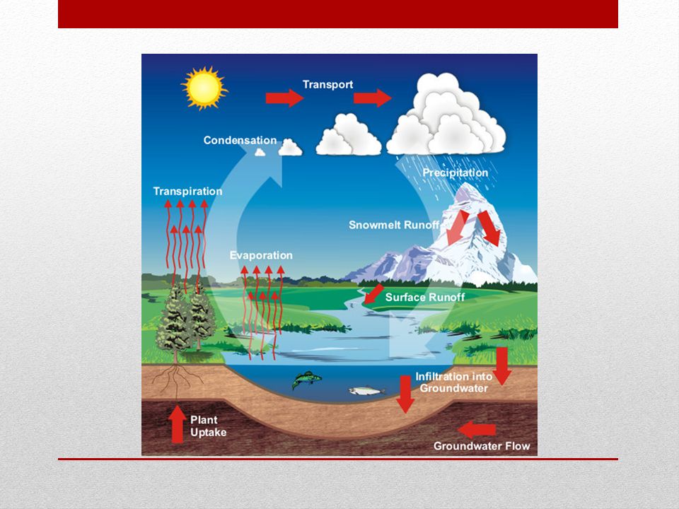


 Flow to and/or gather in basin Evapotranspiration into air Condensation.>")


