Download presentation
Presentation is loading. Please wait.

1
Tacostan

2
Factors Contributing to Climate 30°N, 150°E The Kuroshio current warms up the West side of the Island, and the other side stays cold Mt. Neverest (extinct volcano as tall as Mt. Everest) There is wind from Japan, cooling the west side, and making it the same temp as the east side. Source: Google Images 11/05/07 images.google.com
 There is wind from Japan, cooling the west side, and making it the same temp as the east side. Source: Google Images 11/05/07 images.google.com.")
3
Location 30N, 150E Source: http://blue.utb.edu/paullgj/geog3333/lectures/oceancurrents-1.gif

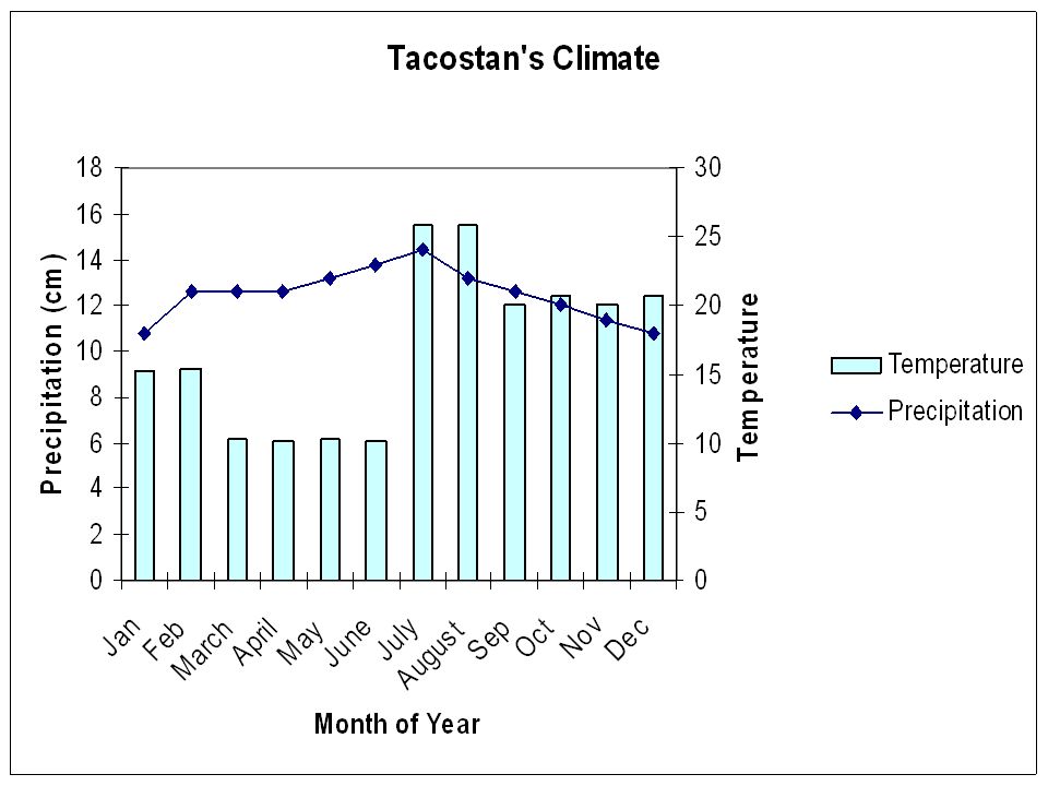
4
Climate Description – 150-200 words Tacostan is 30°N, 150°E. It is a mixed forest. It’s cold in the winters, and hot in the summer. It is a bit humid in the forest, and that means it is a good place for growing mangos. We need a field to grow ingredients for tacos, so we have a field for vegetables. It is averagely 18-24 degrees Celsius each year. The average precipitation each year is 1147 mm each year. Its highest mountain is Mount Neverest, which is on the south coast of the island. The other mountain is Mt. Venus. The islands lake is called Lakers Lake. The other lake is called Lake of Kiwis. The island has 3 rivers, known as Timothy River, River of Tacos, and Pepper River. The animals that can live there are Kiwis, Centipedes, Flies, Ants, Owls, Snakes, and Emus. It snows in the winter. It has fir trees and leaved trees. The precipitation is mainly snow in the winter. The summers are a bit warm. Due to the warm Kurishio current on the west, the water on the West side of the island is warm, but the east side is cool. The west side of the island is not too hot, and the east side isn’t hot. It has a river going through the field as a source of water. (220 words) Source: Location, climate URL: http://tas-ms-6-island-0708.wikispaces.com/Location-Climate Source: Google Images URL: http://images.google.com/images?sourceid=ie7&rls=com.microsoft:enUS&ie=UTF- 8&oe=utf8&q=Wind+patterns.&um=1&sa=N&tab=wi
 Source: Location, climate URL: Source: Google Images URL: sourceid=ie7&rls=com.microsoft:enUS&ie=UTF- 8&oe=utf8&q=Wind+patterns.&um=1&sa=N&tab=wi.")
6
Tacostan’s Agriculture, Aquaculture and Land Area

7
Tacostan Land Our land is 40% arable. The rest of it is either Mountains, Forests, Cities, or Coastal Area.

8
Tacostan’s Agriculture Our land eats Beef and steak because of cows that live on the island. We have mangos because there are some places that always stay warm. We have a field for carrots and tomatoes and bell pepper. Kiwis (Birds) give us poultry, but we respect them, so we don’t kill them. We eat the Kiwis that die of old age, then we quickly cook and eat them. We can use Kiwi eggs as eggs. We also make tacos. Due to the many fish around the sea, we can get many fish. Source: Google Images URL:http://images.google.com/images? hl=en&q=Kiwi&um=1&ie=UTF- 8&sa=N&tab=wi
 give us poultry, but we respect them, so we don’t kill them. We eat the Kiwis that die of old age, then we quickly cook and eat them. We can use Kiwi eggs as eggs. We also make tacos. Due to the many fish around the sea, we can get many fish. Source: Google Images URL: hl=en&q=Kiwi&um=1&ie=UTF- 8&sa=N&tab=wi.")
9
Imports and Exports We import chili, cumin, garlic, corn, bikes, and light bulbs. Our main trading partners are Japan and Guam. We export tacos, oil, mangos, beef, poultry, fish, and eggs. Our other main trading partners are China and the Philippines. Source: Info please. URL: www.infoplease.com/

10
Climate Concerns Global warming sometimes make the winters warm, so it might not snow.

Similar presentations


>")


 SS6G10 The student will explain the impact of location, climate, natural resources, on population distribution in Europe. a.Compare how the location,>")


