Download presentation
Presentation is loading. Please wait.

1
Paths Toward CAD and GIS Interoperability Bo Guo, PhD, PE Gistic Research Inc.

2
Outline CAD and GIS Differences Interoperability Paths Case Study: UDOT ROW Research Project

3
CAD and GIS: The Difference (I) ItemCADGIS HistoryInitiated by academia, driven by private industry Driven by government projects UsersArchitects, engineers, land surveyors Most all GeometryMan-made objects Design, presentation through detail geometric specifications Natural Environment Analysis and presentation through abstraction & attribution TopologyNoneImportant Modeling space 2D/3D orthogonalGeodetic or various projected spatial reference systems Geo-referencesNone or Ground surfaceGrid surface Scale/ExtentsLarge scale, small extentsSmall scale, large extents AccuracyHigherLower
 ItemCADGIS HistoryInitiated by academia, driven by private industry Driven by government projects UsersArchitects, engineers, land surveyors Most all GeometryMan-made objects Design, presentation through detail geometric specifications Natural Environment Analysis and presentation through abstraction & attribution TopologyNoneImportant Modeling space 2D/3D orthogonalGeodetic or various projected spatial reference systems Geo-referencesNone or Ground surfaceGrid surface Scale/ExtentsLarge scale, small extentsSmall scale, large extents AccuracyHigherLower")
4
CAD and GIS: The Difference (II) ItemCADGIS AttributionVia symbol (style, color etc.), layers, text label, cell etc. database 2-D Geometry Primitives Include curve (circle and spline)Circle has limited support spline is not supported Data organization Layers or levels in single document Each data layer is unit at the database level RDMBS support LimitedGood FormatsProprietary: DWG, DGN, etc. Intermediate: DXF, IGES Common: Oracle Spatial? Proprietary: Shapefiles, SDE, etc. RDBMS spatial types: Oracle, IBM, ProgreSQL, MSSQL etc. Standards: OGC standards
Circle has limited support spline is not supported Data organization Layers or levels in single document Each data layer is unit at the database level RDMBS support LimitedGood FormatsProprietary: DWG, DGN, etc. Intermediate: DXF, IGES Common: Oracle Spatial. Proprietary: Shapefiles, SDE, etc. RDBMS spatial types: Oracle, IBM, ProgreSQL, MSSQL etc. Standards: OGC standards.")
5
Why CAD-GIS Integration GIS & CAD have more differences than similarities; they are destined to co-exist GIS needs data; there is an abundance of survey and design data developed and maintained in CAD files Design engineers need geographic context in which objects are to be designed and built in CAD In a project development cycle - PhaseMain Data SourceIntegration direction PlanGIS Design/BuildCADGIS -> CAD OperateGISCAD -> GIS

6
Polls Which direction of CAD-GIS conversion is more important in your organization? List assets in your organization stored in CAD that need to be converted to GIS List assets in your organization stored in GIS that need to be converted to CAD

7
Interoperability via Data Conversion CAD GIS CAD Data Format GIS Data Format CAD Software GIS Software CAD Data Format GIS Data Format GIS CAD CAD Software GIS Software Via intermediate formats (such as DXF, IGES) that are supported by both CAD and GIS Software vendors Direct convert via 3 rd -party tool such as FME by Safe Software
 that are supported by both CAD and GIS Software vendors Direct convert via 3 rd -party tool such as FME by Safe Software")
8
Interoperability via Common Format CAD and GIS software supports read-and-write to some common formats that should meet the following criteria: Open Standards OGC Simple Feature, SQL/MM, Simple Features 2.0 Support Curves Oracle Spatial SQL Server 2012 Supports NURBS Curves Oracle 12 Common Formats GIS CAD CAD Software GIS Software

9
UDOT ROW: Project Objectives Select the best path for converting DGN files to GIS in Oracle Spatial Identify additional CAD standards Integrate with existing ROW application

10
CAD Drawing Evaluation Survey data is not fully available for CS projection into UTM Lack of conformance to existing CAD standards Existing CAD standards need to be extended to support conversion Historical CAD drawings and survey data may not be available

11
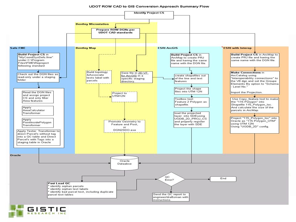
Selection of Paths 4 Approaches Bentley Bentley + ESRI Bentley + ESRI with Interop Kit Bentley + FME 5 Major Criteria Coordinate System Oracle Export QA/QC Automation License

13
CAD to GIS Conversion Issues Spatial Reference System Survey Plane vs. Projection Plane Geometry Multiple spatial types Curves Topology Build ROW parcels and associate text labels with parcels Attribution Organizational CAD standards Extraction of Annotation Attribute and Object association QC Orphans, Bad text label, Topology errors, Duplicate labels etc.

14
UDOT ROW - Phased Implementation PhaseDescription Phase I Capture and QC parcel info in ACTIVE projects into Oracle Spatial and tie geometry with ROW application (This phase is critical as it also handles on-going maintenance of parcel fabric once it is built in Phase II.) Phase II Spatially-enable entire ROW inventory by building statewide ROW parcel fabric in Oracle Spatial database Phase III Build web-based ROW applications for internal or public consumption
 Phase II Spatially-enable entire ROW inventory by building statewide ROW parcel fabric in Oracle Spatial database Phase III Build web-based ROW applications for internal or public consumption")
15
UDOT ROW - Phase I Diagram FME Process - Geometry filter - Area calculation - CS transformation - Exclude parcels without tags, to error log - Write parcels with tags to ROW parcel table in Oracle Begin UGear Admin Web Application to setup the project for GIS loading: - define the DGN files to be loaded - define the project coordinate systems - define recipient's) of QC messages - browse processing log and error log - schedule script execution time SDE/Oracle STG_ROW_PARCELS STG_ROW_ERR_LOG Additional QC - Comparing spatial with non- spatial ROW database - Duplicate parcel attributes - Incomplete parcel attributes - Spatial relationship among existing/take/remainder Status email to predefined recipients Automated ProcessBy Administrator UGear Phase I System Flow Overview UDOT GIS-Enabled Application for ROW
 of QC messages - browse processing log and error log - schedule script execution time SDE/Oracle STG_ROW_PARCELS STG_ROW_ERR_LOG Additional QC - Comparing spatial with non- spatial ROW database - Duplicate parcel attributes - Incomplete parcel attributes - Spatial relationship among existing/take/remainder Status to predefined recipients Automated ProcessBy Administrator UGear Phase I System Flow Overview UDOT GIS-Enabled Application for ROW")
16
Resource Impact TaskDescription UDOT StaffConsultant Staff Staff Essential Skills TimeTitle Essential Skills Time Projection System Admin - Ensure the Proj CS parameters are available and correct. Enter into the Admin application. Consultant - Provide the info on a timely manner Admin ROW Business, Survey 2-5 hours per Project Engineer / Surveyor Survey and/or GIS 2 hours QC Admin - Advice consultants on fixing the errors. Consultant - Fix the QC issues Admin ROW Business, CAD 2 hours per Project Engineer / Draftsman CAD and / or ROW Design 2 hours per project CAD File Prep Consultant - Preparing the DGN files per new standards None Engineer / Draftsman CAD and / or ROW Design 2 minutes per parcel shape

17
Q & Q U E S T I O N S A N S W E R S A

Similar presentations


 732-7188 GIS and Mapping Procedures in ArcMap 9.x Creating an ArcMap Project Editing an ArcMap Project Printing an ArcMap Project.>")


