Download presentation
Presentation is loading. Please wait.

1
The Paper Map A long and rich historyA long and rich history Has a scale or representative fractionHas a scale or representative fraction –The ratio of distance on the map to distance on the ground A common source of data for GISA common source of data for GIS –Obtained by digitizing or scanning the map and registering it to known locations on the Earth’s surface Digital representations are much more powerful than their paper equivalentsDigital representations are much more powerful than their paper equivalents

2
Types of Maps I. Mental – Our self image of the world II. Physical (Tangible) A. General Reference Maps – Shows Place (e.g. navigation, atlas) B. Thematic Maps – Shows distribution of a single entity (e.g. geology) 1. Qualitative City names, Soil Type 2. Quantitative (amounts, costs) Population, pH A GIS database is usually a set of thematic maps which when taken as a whole represents place.
 A. General Reference Maps – Shows Place (e.g. navigation, atlas) B. Thematic Maps – Shows distribution of a single entity (e.g. geology) 1. Qualitative City names, Soil Type 2. Quantitative (amounts, costs) Population, pH A GIS database is usually a set of thematic maps which when taken as a whole represents place..")
3
A GIS database is typical a set of thematic layers that represent different information types. Information can be stored using different data structures depend on their characteristics.

4
Value of Maps Maps are perhaps as fundamental to society as language and the written word. Million of maps are created and distributed each year. They are the preeminent means of recording and communicating information about the location and spatial characteristics of the natural world and of society and culture.

5
Value of Maps Maps gain their value in three ways: 1. As a way of recording and storing information Location of USGS water-quality test sites in Wisconsin

6
Value of Maps 2. As a means of analyzing locational distributions and spatial patterns Maps let us recognize spatial distributions and relationships and make it possible for us to visualize and hence conceptualize patterns and processes that operate through space. Example: Query water quality data to find sites with high nitrate.

7
Value of Maps Environmental factors affecting poverty in Africa by Christine Byer, George Mason University

8
Value of Maps 3. As a method of presenting information and communicating findings Maps allow us to convey information and findings that are difficult to express verbally. Maps can also be used to convince and persuade, or even propagandize. GIS supports these activities by making it more efficient to capture, store, analyze and display spatial data. If anything GIS has increased the importance of maps in decision-making and our daily lives.

9
Five Ms of Applied GIS Mapping – location of entities Measuring – distance, counts Monitoring – change over time Modeling – integration of data Managing – decision-making

10
GIS Interest is Rising Applications via Internet (data and model services) Price reductions Greater awareness Improved ease of use Better technology (faster computers; more storage) Proliferation of DATA Commercial software packages Real applications (operational tools) Proven cost:benefit cases
 Price reductions Greater awareness Improved ease of use Better technology (faster computers; more storage) Proliferation of DATA Commercial software packages Real applications (operational tools) Proven cost:benefit cases")
11
Four Domain Areas Government Business Transportation and Logistics Environment

12
Local Government Major user of GIS –70-80% of local government tasks are geographically- related Many applications, e.g. –Asset inventories –Transportation planning –Land management –Economic development –Elections –Public health delivery

13
Tax Assessment Raising revenue from property taxes –Maintain property register –Evaluate land/property value fairly –Deal with public enquiries and complaints Assign value to property based on –Cost of replacement –Income if rented –Market comparison with recent sales

15
Business and Service Planning Application of GIS to retail market decision making GIS has been applied at all scales –Operational – processing day-to-day transactions (e.g. delivery vehicle routing) –Tactical – allocation of resources to short-term (weekly) problems (e.g. target marketing promotional campaigns) –Strategic – longer term goals and missions (e.g. store location planning)
 –Tactical – allocation of resources to short-term (weekly) problems (e.g. target marketing promotional campaigns) –Strategic – longer term goals and missions (e.g. store location planning).")
16
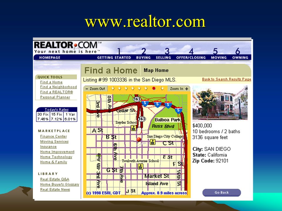
www.realtor.com
17
Logistics Many applications of GIS in transportation, utilities and logistics, e.g. –Infrastructure maintenance –Travel planning –Routing –Vehicle tracking Two components –Static – infrastructure –Dynamic – vehicles (linked to GPS, mobile GIS)
.")
18
Planning for Emergency Evacuation Major natural and human-induced events may necessitate area evacuations GIS can be used to create effective evacuation vulnerability maps based on –Distribution of population –Street map Model demand and impact of bottlenecks on speed of evacuation using standard GIS network tools –Adjacency, connectivity, shortest path network calculation

19
Potential Congestion – Hazard Management

20
Environment Many environmental applications of GIS –Natural resource inventory –Environmental remediation –Conservation Planning –Precision agriculture –Natural hazard mitigation –Environmental assessments –Resource Management and Decision-Making

21
George Host, et al. NRRI, University of Minnesota - Duluth

22
Modeling Deforestation Probability Surface Observed Deforestation Modeling Deforestation Risks for the Maya Biosphere Reserve, Guatemala

23
Top Five Benefits of GIS Cost Savings and Increased Efficiency Better Decision Making –Decisions on location (hazards, businesses, utilities) Improved Communication –Graphic Language – “A picture is worth a 1000 words” Better Recordkeeping Managing Geographically –Local Knowledge –Global Extent
 Improved Communication –Graphic Language – A picture is worth a 1000 words Better Recordkeeping Managing Geographically –Local Knowledge –Global Extent")
Similar presentations


 John Wiley and Sons Ltd 2. A Gallery of Applications.>")
 John Wiley and Sons Ltd 1. Systems, Science and.>")
>")


 Fundamentals for Program Managers.>")
