Download presentation
Presentation is loading. Please wait.

1
Coordination of Indiana GIS through dissemination of data and data products, education and outreach, adoption of standards, and building partnerships Building Relationships in 2010 Shaun Scholer Incoming President

2
Coordination of Indiana GIS through dissemination of data and data products, education and outreach, adoption of standards, and building partnerships What does a GIS Consist of…

3
Coordination of Indiana GIS through dissemination of data and data products, education and outreach, adoption of standards, and building partnerships Building Our Relational Network 1.Board members communicating with of their sector 2.IGIC working with state organizations 3.Promote Regional GIS User Groups 4.Scheduling fun personal team building events

4
Coordination of Indiana GIS through dissemination of data and data products, education and outreach, adoption of standards, and building partnerships Indiana Geographic Information Council WHAT WE DO IGIC coordinates geographic information resources in Indiana - we take the lead in getting people and organizations working with each other toward common goals. IGIC provides education, policy guidance, and technology resources to hundreds of individuals and organizations throughout Indiana. MISSION Coordination of Indiana GIS through dissemination of data and data products, education and outreach, adoption of standards, building partnerships and the IndianaMap.

5
Coordination of Indiana GIS through dissemination of data and data products, education and outreach, adoption of standards, and building partnerships IGIC Membership Benefits of Membership Network with other geospatial professionals Members-only portion of the IGIC website Members-only rate for annual GIS Conference Professional development activities Help shape policies and positions Monthly GIS newsletter More…

6
Coordination of Indiana GIS through dissemination of data and data products, education and outreach, adoption of standards, and building partnerships Strength in Numbers 2010 Orthophotography National Hydrography Data Project 2005 Orthophotography Annual GIS Conference

7
Coordination of Indiana GIS through dissemination of data and data products, education and outreach, adoption of standards, and building partnerships Workgroups Board Committees Workgroups Members

8
Coordination of Indiana GIS through dissemination of data and data products, education and outreach, adoption of standards, and building partnerships Committees and Workgroups (Boots on the Ground) Work closely with people who have common interests Helping fellow GIS professionals Working with the nuts and bolts. Being the sounding board for the state officials

9
Coordination of Indiana GIS through dissemination of data and data products, education and outreach, adoption of standards, and building partnerships Out-going IGIC Board Members Bill Holder, County Brenda King, Commercial Matt Riggs, At Large Andrew Swenson, At Large Aaron Shaw, Regional GIS Consortia Jeff Stelle, Rural Municipal Bruce Nielsen, Federal

10
Coordination of Indiana GIS through dissemination of data and data products, education and outreach, adoption of standards, and building partnerships Incoming IGIC Board Members Elected: Val Swift, County Chris Walls, Commercial Mike Martin, At Large Rick Hill, At Large Jim Stout, Regional GIS Consortia Re-Elected: Deb Kuehn (Martin), Municipal Kevin Mickey, University Charline Avey, Utilities Christina McCullough, Critical Infrastructure
, Municipal Kevin Mickey, University Charline Avey, Utilities Christina McCullough, Critical Infrastructure")
11
Coordination of Indiana GIS through dissemination of data and data products, education and outreach, adoption of standards, and building partnerships Duties of the Board of Directors Attend bimonthly meetings Help guide direction of IGIC Receive updates on projects around the state Review grant opportunities Inform IGIC Members Social networking

12
Coordination of Indiana GIS through dissemination of data and data products, education and outreach, adoption of standards, and building partnerships This Year’s Accomplishments 1 st Time Orienteering in downtown Indianapolis 1 st time Geo-Dinner in West Lafayette GIS Educational Seminars 3 rd annual Local Government GIS Coordinators Forum Annual Conferences – Indiana University Exhibited at AIC and IACT

13
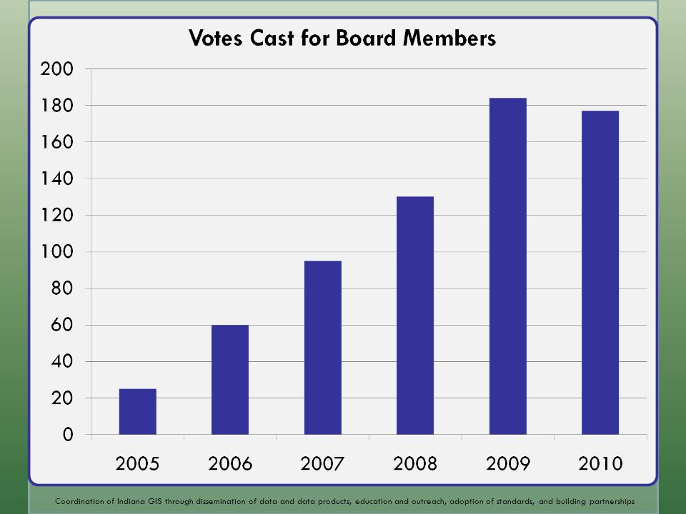
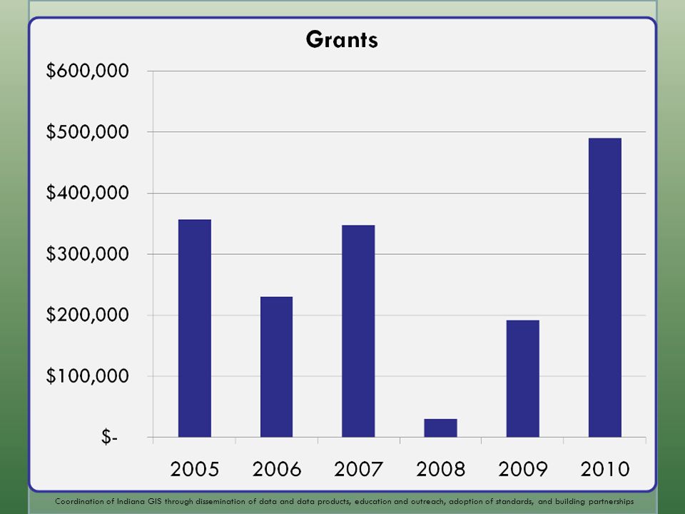
Coordination of Indiana GIS through dissemination of data and data products, education and outreach, adoption of standards, and building partnerships

16
Next Year’s Goals Permanent Funding for GIS in Indiana

17
Coordination of Indiana GIS through dissemination of data and data products, education and outreach, adoption of standards, and building partnerships This Year’s Fun Activities Summer Orienteering at Eagle Creek Park September Golf Outing

18
Coordination of Indiana GIS through dissemination of data and data products, education and outreach, adoption of standards, and building partnerships Cities and Towns Higher Education Counties Professional Development Geo-Dinners Local Gov GIS Coordinators Forum(Birds of a Feather) Present & co-sponsor at AIC, IACT, ISPLS, … Height Modernization Regional Workshop Monthly GIS Educational Seminars GIS Road Shows GIS Days
 Present & co-sponsor at AIC, IACT, ISPLS, … Height Modernization Regional Workshop Monthly GIS Educational Seminars GIS Road Shows GIS Days")
19
Coordination of Indiana GIS through dissemination of data and data products, education and outreach, adoption of standards, and building partnerships 2011 IGIC Conference Conference at Horizon Center in collaboration with Ball State University March 1 st & 2 nd, 2011

20
Coordination of Indiana GIS through dissemination of data and data products, education and outreach, adoption of standards, and building partnerships Social Networking Facebook LinkedIn Twitter Crowdsourcing

21
Coordination of Indiana GIS through dissemination of data and data products, education and outreach, adoption of standards, and building partnerships IGIC Web Stats Classic Web Tools igic.org (average of 206% increase is unique monthly visitors per year) indianamap.org (average of 2,000 unique visitors per month) IGIC-L listserv (1,242 subscribers) Social Media Sites (since October 2009) LinkedIN (126 Members, 40 Posts) Twitter (56 followers, 95 Tweets) Facebook (41 fans, 40 Posts) Slideshare (3 ppt - 604 views) YouTube (1 video - 16 views) bit.ly (100 URLs, 784 clicks on http://bit.ly/qrJPD social media post) http://bit.ly/qrJPD indianamap.org igic.org
 indianamap.org (average of 2,000 unique visitors per month) IGIC-L listserv (1,242 subscribers) Social Media Sites (since October 2009) LinkedIN (126 Members, 40 Posts) Twitter (56 followers, 95 Tweets) Facebook (41 fans, 40 Posts) Slideshare (3 ppt views) YouTube (1 video - 16 views) bit.ly (100 URLs, 784 clicks on social media post) indianamap.org igic.org")
22
Coordination of Indiana GIS through dissemination of data and data products, education and outreach, adoption of standards, and building partnerships 2010 Conference Special thanks to: Conference Committee Indiana University UITS Indiana Geological Surveys

23
Coordination of Indiana GIS through dissemination of data and data products, education and outreach, adoption of standards, and building partnerships Enjoy the Conference and Build Relationships

Similar presentations


>")


