Download presentation
Presentation is loading. Please wait.

1
Emergencies Without Borders Sub-national and transnational mapping of emergency affected areas in Africa in 2004 Dennis J. King Humanitarian Information Unit US Department of State

2
Usual Depiction of Emergencies in Africa, 2003

3
Usual Depiction of HIV Prevalence in Africa

4
Interpolated HIV Prevalence adjusted for Pop Density 54% 40% 30% 15% 5% Interpolated HIV Prevalence model based on more than 1,200 sentinel surveillance sites that have reported HIV prevalence among pregnant women. Multiplying the interpolated HIV prevalence times the adjusted population distribution provides a rough estimate of number of people living with HIV per square kilometer and shows concentrations of people living with HIV.

5
Natural Disaster Events in Africa in 2004

6
Complex Emergency Affected Areas and Refugee Camps in Africa in 2004 Complex Emergency Affected Areas and Refugee Camps in Africa in 2004 Complex Emergency Affected Areas

7
Infant Mortality Rate in Africa – 2000

8
Sample Child Mortality Rates in Africa in 2004

9
CountryLocation<5 MRDateSource AngolaGanda -12.9, 14.6 0.9Sep 2004ACH-S ChadIrimi 7.3, 29.1 2.2Oct. 2004MSF-B DRCKikwit -5.06, 18.8 2.8Apr 2004IRC DRCMutena -6.3, 20.8 5.2Apr 2004IRC DRCMoba -7.5. 29.7 11.3Apr 2004IRC SomaliaBossasso 11.2, 49.2 2.32Jul 2004UNICEF SomaliaBargal 11.2, 51.0 2.39Jul 2004UNICEF SudanKalma camp 13.4, 22.4 11.7Aug 2004WHO SudanEl Geneina 12.5, 24.2 14.1Jun 2004MSF/Epicentre SudanAweil (south)0.7Jul 2004MSF/Epicentre
0.7Jul 2004MSF/Epicentre.")
10
Areas and Incidents of Conflict and Displacement In 2004 So Far in 2005

11
Burundian rebels massacred 180 Congolese refugees in Gatumba camp in August 2004 Sporadic fighting between DRC army, renegade soldiers, armed militia, rebel Democratic Forces for Liberation of Rwanda (FDLR), GOR armed forces, and UNMOC troops in eastern DRC 150,000 Congolese refugees in Uganda, Rwanda and Burundi, over 250,000 Congolese refugees in other countries 200,000 IDPs and 2.2 million affected in DRC Great Lakes transnational emergency
, GOR armed forces, and UNMOC troops in eastern DRC 150,000 Congolese refugees in Uganda, Rwanda and Burundi, over 250,000 Congolese refugees in other countries 200,000 IDPs and 2.2 million affected in DRC Great Lakes transnational emergency")
12
Southeast Asia Avian Influenza

13
Conclusions from Emergencies Without Borders Emergencies are sub-national (affect only specific areas inside a country’s boundaries) and sometimes transnational (cross borders) UN Consolidated Appeals are often transnational/regional (Darfur/Chad, Great Lakes) or sub-national (Chechnya, Bolivia El Chaco drought) Most humanitarian assistance organizations are structured according to country desks/programs and have different entities for refugees and IDPs Transnational humanitarian emergencies require coordination, collaboration and information sharing among multiple organizations Sub-national mapping of emergencies requires more detailed identification of affected areas (provinces, states, districts) and geo- referencing of locations
 and sometimes transnational (cross borders) UN Consolidated Appeals are often transnational/regional (Darfur/Chad, Great Lakes) or sub-national (Chechnya, Bolivia El Chaco drought) Most humanitarian assistance organizations are structured according to country desks/programs and have different entities for refugees and IDPs Transnational humanitarian emergencies require coordination, collaboration and information sharing among multiple organizations Sub-national mapping of emergencies requires more detailed identification of affected areas (provinces, states, districts) and geo- referencing of locations")
14
Data Mining – Enter terms, sources, date perimeters

15
Search Results – Visualization of number of matches

16
Text Extraction – Specific paragraph with words

17
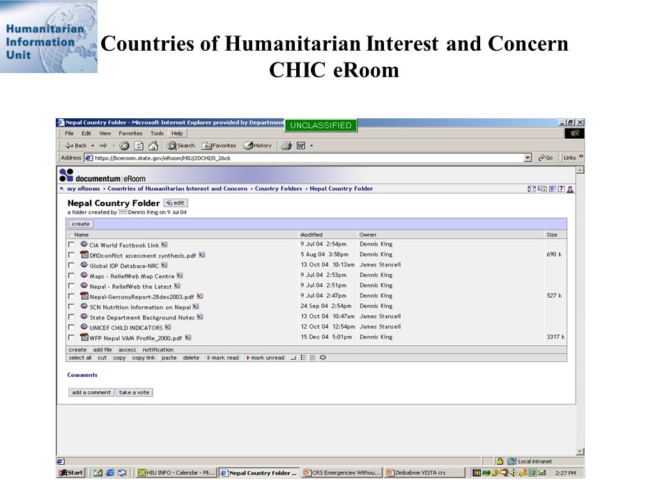
Countries of Humanitarian Interest and Concern CHIC eRoom

19
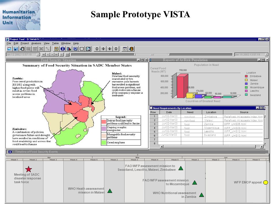
VISTA Visualized Information Synthesized Temporal Analysis A visualization analysis tool to provide situational awareness Geo-spatial - Map of affected area Temporal - Timeline of key events Numerical - Graphs, charts, tables Textual - Hyperlinks to full text documents Interactive, query to create a customized “common operating picture”

20
Sample Prototype VISTA

22
Discussion What are the implications and possible uses of Emergencies Without Borders as an alternative way of visualizing emergencies? Is there interest/value in continual mining, monitoring and mapping of emergencies? Is there interest/value in development of a interactive, web-based visualization analysis tool to display a “common operating picture” of a situation or issue What information management capabilities, skills, and tools are needed?

Similar presentations


. Presidents 1965-1997Mobutu 1997-2001Laurent Kabila 2001-presentJoseph Kabila.>")

 3 rd largest country in Africa (land size) Second Congo.>")


