Download presentation
Presentation is loading. Please wait.

1
NRSCC Agency Report Liu Dingsheng China Remote Sensing Satellite Ground Station National Remote Sensing Center of China WGISS-22 Annapolis, MD, USA September 11-15, 2006 NRSCC MOST

2
NRSCC MOST National Remote Sensing Center of ChinaWGISS-22 September 11-15, Annapolis, USA 2 Agency report - NRSCC Topic New Structure of the National Remote Sensing Center of China New Structure of the National Remote Sensing Center of China Beijing-1 Micro-Small Satellite put into operational Beijing-1 Micro-Small Satellite put into operational New Progress of Dragon Programme New Progress of Dragon Programme Some activities in the next year Some activities in the next year Brief introduction of FY3 Brief introduction of FY3

3
NRSCC MOST National Remote Sensing Center of ChinaWGISS-22 September 11-15, Annapolis, USA 3 NRSCC Structure New Structure of the National Remote Sensing Center of China New Structure of the National Remote Sensing Center of China Ministry of Science and Technology NRSCC Office Engineering Centers R&D BasesDepartments Advisor committee expert committee Joint administrative meeting

4
NRSCC MOST National Remote Sensing Center of ChinaWGISS-22 September 11-15, Annapolis, USA 4 NRSCC Structure New Structure of the National Remote Sensing Center of China New Structure of the National Remote Sensing Center of China Ministry of Science and Technology NRSCC Office Engineering Centers R&D BasesDepartments Advisor committee expert committee Joint administrative meeting Earth Observation Division and Satellite Navigation and Positioning Division

5
NRSCC MOST National Remote Sensing Center of ChinaWGISS-22 September 11-15, Annapolis, USA 5 NRSCC Structure New Structure of the National Remote Sensing Center of China New Structure of the National Remote Sensing Center of China Ministry of Science and Technology NRSCC Office Engineering Centers R&D BasesDepartments Advisor committee expert committee Joint administrative meeting Total 19 departments connected with other ministries R & D Dept. (IRSA, CAS) Training Dept. (PKU, MOE) Remote sensing satellite Dept. (RSGS, CAS) Information Services Dept. (CISM, MLR) GIS Dept. (IGSNRR, CAS) Land resources Dept. (AGRS, MLR) Meteorological Satellite Dept. (NSMC, CMA) …… Beijing Dept. (IRMC, Beijing) …… Divided into Three Types 1)Research and Development 2)Services and Applications 3)Local Provinces
 Training Dept. (PKU, MOE) Remote sensing satellite Dept. (RSGS, CAS) Information Services Dept. (CISM, MLR) GIS Dept. (IGSNRR, CAS) Land resources Dept. (AGRS, MLR) Meteorological Satellite Dept. (NSMC, CMA) …… Beijing Dept. (IRMC, Beijing) …… Divided into Three Types 1)Research and Development 2)Services and Applications 3)Local Provinces.")
6
NRSCC MOST National Remote Sensing Center of ChinaWGISS-22 September 11-15, Annapolis, USA 6 NRSCC Structure New Structure of the National Remote Sensing Center of China New Structure of the National Remote Sensing Center of China Ministry of Science and Technology NRSCC Office Engineering Centers R&D BasesDepartments Advisor committee expert committee Joint administrative meeting Responsible to develop suitable products for application within related field National engineering research center for geoinformatics National Engineering Research Center for Satellite Positioning System National engineering research center for satellite communication

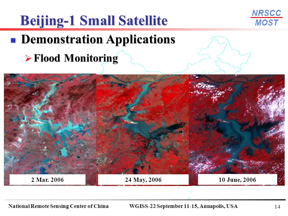
7
NRSCC MOST National Remote Sensing Center of ChinaWGISS-22 September 11-15, Annapolis, USA 7 Oct. 27, 2005 Beijing-1 small- satellite launched successful From October 2005 to March 2006, commissioning and orbit testing successful completed and all main functionality was proven Started at June 6, 2006, Beijing-1 was put into normal operation Many demonstrations for the application of Beijing-1 data have been started and some preliminary results were archived Beijing-1 Small Satellite

8
NRSCC MOST National Remote Sensing Center of ChinaWGISS-22 September 11-15, Annapolis, USA 8 Beijing-1 Small Satellite Mass: 166.4 kg Optical imagery (at Nadir) with Ground Sampling Distance of 4m pan (24 km swath) 32m multi-spectral (600 km swath) Sun-synchronous orbit (686km) On Board Storage: HDDR (240Giga Bytes) + SSDR (4 Giga Bytes) Beijing-1 Summary
 with Ground Sampling Distance of 4m pan (24 km swath) 32m multi-spectral (600 km swath) Sun-synchronous orbit (686km) On Board Storage: HDDR (240Giga Bytes) + SSDR (4 Giga Bytes) Beijing-1 Summary")
9
NRSCC MOST National Remote Sensing Center of ChinaWGISS-22 September 11-15, Annapolis, USA 9 Beijing-1 Small Satellite Data Collection: Dec. 2005 to May, 2006 Data Collection: Dec. 2005 to May, 2006

10
NRSCC MOST National Remote Sensing Center of ChinaWGISS-22 September 11-15, Annapolis, USA 10 Beijing-1 Small Satellite Tianjin Harbour (MS Data)
")
11
NRSCC MOST National Remote Sensing Center of ChinaWGISS-22 September 11-15, Annapolis, USA 11 Beijing-1 Small Satellite Tehran Airport, Iran (Pan) Tehran Airport, Iran (Pan)
 Tehran Airport, Iran (Pan)")
12
NRSCC MOST National Remote Sensing Center of ChinaWGISS-22 September 11-15, Annapolis, USA 12 Beijing-1 Small Satellite Hanoi, Vietnam

13
NRSCC MOST National Remote Sensing Center of ChinaWGISS-22 September 11-15, Annapolis, USA 13 Beijing-1 Small Satellite Demonstration Applications Demonstration Applications Landuse Landuse

14
NRSCC MOST National Remote Sensing Center of ChinaWGISS-22 September 11-15, Annapolis, USA 14 Beijing-1 Small Satellite Demonstration Applications Demonstration Applications Flood Monitoring Flood Monitoring 24 May, 2006 10 June, 2006 2 Mar. 2006
15
NRSCC MOST National Remote Sensing Center of ChinaWGISS-22 September 11-15, Annapolis, USA 15 Beijing-1 Small Satellite Fire Monitoring Fire Monitoring 2006 5 20 2006 5 27

16
NRSCC MOST National Remote Sensing Center of ChinaWGISS-22 September 11-15, Annapolis, USA 16 Beijing-1 Small Satellite Environmental Monitoring Environmental Monitoring Forestry Wetland Sandstorm

17
NRSCC MOST National Remote Sensing Center of ChinaWGISS-22 September 11-15, Annapolis, USA 17 3rd annual Dragon Symposium From 10 to 14 July 2006, the 3rd annual Dragon Symposium successful held in beautiful Lijiang city, ChinaLijiang city

18
NRSCC MOST National Remote Sensing Center of ChinaWGISS-22 September 11-15, Annapolis, USA 18 3rd annual Dragon Symposium Lijiang city, a world famous cultural heritage site in China. Lijiang city

19
NRSCC MOST National Remote Sensing Center of ChinaWGISS-22 September 11-15, Annapolis, USA 19 3rd annual Dragon Symposium

20
NRSCC MOST National Remote Sensing Center of ChinaWGISS-22 September 11-15, Annapolis, USA 20 3rd annual Dragon Symposium Dragon Programme is the joint Sino-European project sponsored by NRSCC and ESA Started fromApril 2004, the Dragon Programme is a dedicated three-year Earth Observation exploitation programme which focuses on science and applications development in China using mainly data from the ERS and Envisat missions Nearly 170 scientists attended the meeting and the 16 project teams Reported their progress and latest results The total progress and results are satisfied by both side and it is decided the Dragon-II shall be started at 2008 During the meeting, we have discussed with the programme co-coordinators how to make use Grid TT results to serve the data exchange and application-oriented processing. It is expected to join Dragon programme during second period

21
NRSCC MOST National Remote Sensing Center of ChinaWGISS-22 September 11-15, Annapolis, USA 21 New national 5 years plan Started from 2006 New national 5 years plan Started from 2006 Research and development shall be concentrated on the operational application of earth observation in the field agriculture, forest, disaster and environment monitoring, etc. Research and development shall be concentrated on the operational application of earth observation in the field agriculture, forest, disaster and environment monitoring, etc. More detail plans are planed to finish at the end of this year or the beginning of next year More detail plans are planed to finish at the end of this year or the beginning of next year Three satellites are expected to launch next year Three satellites are expected to launch next year First one of China Small Satellite Constellation for Environment and Disaster Monitoring First one of China Small Satellite Constellation for Environment and Disaster Monitoring Cbers-02B (similar with Cbers-01 but added a 2.34m pan. imager) Cbers-02B (similar with Cbers-01 but added a 2.34m pan. imager) FY-3A, the first one of the Second Generation of Polar- Orbiting Meteorological Satellites FY-3A, the first one of the Second Generation of Polar- Orbiting Meteorological Satellites Some activities in the next year
 Cbers-02B (similar with Cbers-01 but added a 2.34m pan. imager) FY-3A, the first one of the Second Generation of Polar- Orbiting Meteorological Satellites FY-3A, the first one of the Second Generation of Polar- Orbiting Meteorological Satellites Some activities in the next year.")
22
NRSCC MOST National Remote Sensing Center of ChinaWGISS-22 September 11-15, Annapolis, USA 22 The main mission objectives for FY-3: To provide global sounding of 3-dimensional thermal and moisture structures of the atmosphere, cloud and precipitation parameters to support global and regional numerical weather prediction To provide global imaging to support short range weather forecasting and real time monitoring of meteorological/hydrological disasters and surface environment anomaly To provide necessary data for deriving important geophysical parameters to support researches on global change and climate change To collect and relay important data Constellation FY-3 Constellation will be consisted of two experience satellites and 6 operational satellites Brief Brief Introduction of FY3

23
NRSCC MOST National Remote Sensing Center of ChinaWGISS-22 September 11-15, Annapolis, USA 23 Brief Brief Introduction of FY3 FY-3A satellite specifications and major parameters Weight2200 Kg OrbitSun-synchronous Altitude (km)836.4 Power1100 Watts Weight2200 Kg Orbital period (minutes)102.86 Inclination (degrees)98.728 Eccentricity>0.005 Equatorial crossing time10:10 (a.m.) Orbital maintenances10 minutes within two years Onboard data storage160 Gb Attitude ControlThree-axis stabilization Launch VehicleLM-4B
836.4 Power1100 Watts Weight2200 Kg Orbital period (minutes) Inclination (degrees) Eccentricity>0.005 Equatorial crossing time10:10 (a.m.) Orbital maintenances10 minutes within two years Onboard data storage160 Gb Attitude ControlThree-axis stabilization Launch VehicleLM-4B")
24
NRSCC MOST National Remote Sensing Center of ChinaWGISS-22 September 11-15, Annapolis, USA 24 Brief Brief Introduction of FY3 Payloads onboard FY-3A 1.Infrared Atmospheric Sounder (IRAS) 2.MicroWave atmospheric Temperature Sounder (MWTS) MicroWave atmospheric Humidity Sounder (MWHS, similar to AMSU-B) 1.Multichannel Atmospheric Infrared Sounder (MAIRS) 2.Solar Backscatter Ultraviolet and Total Ozone Sounder (SBUV/TOS) 3.Visible and Infrared Radiometer (VIRR, 10 channels, similar to radiometer aboard FY-1C) 4.Medium Resolution Spectral Imager (MERSI) 5.MicroWave Radiation Imager (MWRI) 6.Earth Radiation Budget Unit (ERBU) 7.Space Environment Monitor (SEM)
 2.MicroWave atmospheric Temperature Sounder (MWTS) MicroWave atmospheric Humidity Sounder (MWHS, similar to AMSU-B) 1.Multichannel Atmospheric Infrared Sounder (MAIRS) 2.Solar Backscatter Ultraviolet and Total Ozone Sounder (SBUV/TOS) 3.Visible and Infrared Radiometer (VIRR, 10 channels, similar to radiometer aboard FY-1C) 4.Medium Resolution Spectral Imager (MERSI) 5.MicroWave Radiation Imager (MWRI) 6.Earth Radiation Budget Unit (ERBU) 7.Space Environment Monitor (SEM)")
25
NRSCC MOST National Remote Sensing Center of ChinaWGISS-22 September 11-15, Annapolis, USA 25 Brief Brief Introduction of FY3 FY-3A in Flying Mode

26
NRSCC MOST National Remote Sensing Center of ChinaWGISS-22 September 11-15, Annapolis, USA 26 Agency report - NRSCC Thanks!

Similar presentations


>")


 Research Works Presentation to WGISS-16 Chiang Mai, Thailand September 15, 2003 Pro. Liu Dingsheng, Dr.>")


