Download presentation
Presentation is loading. Please wait.

1
Maps help us get to know Delaware.
The Target Standard 1 Maps help us get to know Delaware.

2
Did You Know? Delaware is one of the states found on the flat coastal plain of the eastern United States.

3
Did You Know? Delaware has three counties: New Castle to the north, Kent in the center, and Sussex to the south. southhttp://

4
Did You Know? When a drawing of Delaware is by itself it is difficult to know what its location is. We can learn location by identifying other places around it. This is relative location.

5
Did You Know? The relative location of Delaware is between Maryland and New Jersey and south of Pennsylvania.

6
Did You Know? Delaware’s relative location is on a peninsula, a strip of land with water on three sides. The Delmarva Peninsula is surrounded by the Chesapeake Bay, the Delaware Bay and the Atlantic Ocean.

7
Did You Know? Delaware is a very flat state that sits along the coast line. It has many rivers that have supported fishing and boating for many years.

8
Did You Know? Delaware also has an organized road system which crosses the many waterways in the state and connects the urban settlements. maps.com

9
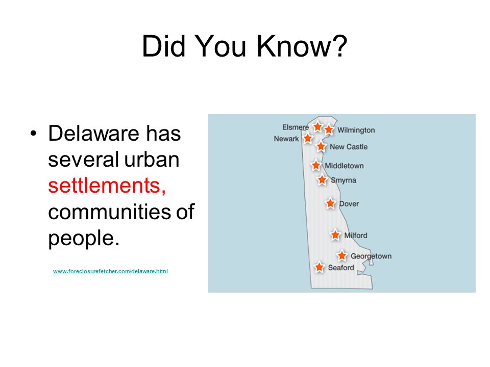
Did You Know? Delaware has several urban settlements, communities of people.
10
Did You Know? Wilmington is the largest settlement in Delaware. It is located in northern New Castle County. About 73,000 people live in the city. The Brandywine and Christina River meet there.

11
Did You Know? The city of Dover is located 41 miles south of Wilmington. The capitol is located in Dover, as well as Dover Downs Race Track. About 32,000 people live in Dover.

12
Did You Know? Thirty three miles south of Dover is the city of Georgetown. There is a parade in Georgetown after big state elections (called Returns Day) and the candidates “bury the hatchet”.
 and the candidates bury the hatchet .")
13
Did You Know? Most of Delaware is a coastal plain. That describes low flat land that is along the coast.

14
Did You Know? In northern Delaware, the rocky Peidmont drops down to the coastal plain. This change in elevation (the height of a place above sea level) is called the Fall Line.
 is called the Fall Line.")
15
Did You Know? A topographic map shows how much the land rises or falls. Lines of elevation are used. So you can follow the 100 (foot) line and it will be the same elevation above sea level everywhere along that line.
 line and it will be the same elevation above sea level everywhere along that line. id=53199&arti...")
16
Did You Know? When creeks and streams run through the fall line, there will be rapids and small waterfalls. dsf.chesco.org/ccparks/hibernia

17
Think About It How might learning about the geography of Delaware help you understand what is happening in the news? How might it help you learn about the past?

18
Maps help us get to know the United States.
The Target Maps help us get to know the United States.

19
Did You Know? The United States has many elevation changes. The high, rugged Rocky, Sierra Nevada, and Cascade Mountains are in the west, and the worn down Appalachian Mountains are in the east. Rivers also divide the continent. Major rivers are the Columbia, the Colorado, the Missouri, and the Mississippi.

20
Did You Know?

21
Did You Know? The United States also has different climate regions. The Eastern Seaboard is seasonal (temperate) with the temperatures getting hotter the farther south you go (subtropical). The middle of the country has extreme seasons with less rain in the west. The southwest is hotter and more arid (dryer) than other regions. regentsprep.org/.../physicalgeography.cfm
 with the temperatures getting hotter the farther south you go (subtropical). The middle of the country has extreme seasons with less rain in the west. The southwest is hotter and more arid (dryer) than other regions. regentsprep.org/.../physicalgeography.cfm.")
22
Did You Know?

23
Think About It In which climate regions would each city be found?
New York -Dallas Philadelphia -Houston Washington, D.C. -St. Louis Atlanta -Salt Lake City Miami -Chicago Denver -Phoenix Los Angeles -Seattle

24
Think About It How might learning about the geography of the United States help you understand what is happening in the news? How might it help you learn about the past?

25
Latitude and longitude help identify absolute location.
The Target Latitude and longitude help identify absolute location.

26
Did You Know? Early geographers discovered a way to identify any exact place on the earth called absolute location. They started with imaginary lines of latitude. Latitude lines go east to west around the globe. plantwatch.sunsite.ualberta.ca/determineloc.php

27
Did You Know? Measuring latitude is like measuring how far up and down a ladder you climb. Any steps north of the equator measure north latitude and steps south of the equator measure south latitude.

28
Did You Know? Longitude lines go north and south, from North Pole to South Pole.

29
Did You Know? Measuring longitude is like moving on a football field. The 50 yard line on the globe is called the Prime Meridian. It is 0 degrees. Moving to the left measures west longitude. Moving to the right measures east longitude.

30
Did You Know? Imagine laying the latitude lines over the longitude lines on the map or globe. What is left is a grid. Geographers use the grid to locate an exact place on the earth.

31
Did You Know To find your absolute location (exact) you must measure both the north and south latitude and the east and west longitude. . . . . .

32
Think About It How would you find the absolute location of Dover, Delaware? Is it north or south of the equator. Is it east or west of the Prime Meridian?

33
Think About It How are relative location and absolute location connected? When would it be best to use relative location? When would it be best to use absolute location? ?

34
The Target Human Settlements Are Connected.

35
Did You Know? Long ago people had to walk or ride horses. Travel took a long time. Today jets fly us all over quickly and efficiently. What route would a plane take from Philadelphia to Los Angeles? to Chicago? Which route takes longer?

36
Did You Know? Settlements are connected by trains and trucks, too. Bananas that come into the Port of Delaware (Wilmington) are trucked all over the east coast. Trains carry new cars from the factory across the nation.
 are trucked all over the east coast. Trains carry new cars from the factory across the nation.")
37
Did You Know? Today settlements that are far from each other are still connected. You might call your grandmother in Colorado and talk about the weather in both places. You also might check the internet for information about Disney World before you take your vacation. Long distances don’t seem as far away. Now they are only a click away!

38
Think About It How might people in St. Louis understand what the weather is like in Delaware? Explain.

39
Mental Maps of Different Scales are Linked.
The Target Mental Maps of Different Scales are Linked.

40
Did You Know? We can see Delaware on a map by itself but we can also locate it on a map of the Eastern United States and even on a map of the whole United States.

41
Did You Know? The more we see beyond our own little state, the more we are connected to bigger settlements. We might enjoy eating crabs from the Chesapeake Bay. Lots of people root for the Baltimore Ravens and the Philadelphia Phillies. Even the environment is connected. Wastes that might be dumped in the Delaware River in Trenton will affect a trip to the beach!

42
Think About It What are ways people in local Delaware might be connected to people or ideas from big cities such as Washington, DC? to New York City? Explain.

Similar presentations


 A Meeting of Different Worlds Unit 1: Geography, Early Americans, Exploration, and Colonization.>")


