Download presentation
Presentation is loading. Please wait.

1
The Impact of Nearby Structures and Trees on Sigma Theta Measurements Tom Bellinger Illinois Dept of Nuclear Safety 1035 Outer Park Drive Springfield IL 62704 bellinger@idns.state.il.us

2
Why did I do this study? Determine if nearby trees were impacting the lower level wind data particularly at Zion Visualize the extent of any tower shadow on the wind direction sensor Visualize the extent of crossarm sensor shadow on the wind direction sensor

3
CROSSARM SENSOR SHADOW TOWER SHADOW WD WS

4
Obtaining Average Sigma Thetas Zion (7/1990-12/2001) Dresden, Braidwood, LaSalle (12/1998-12/2001) 15 minute averages were used Averaged by tower level Averaged by 36 meteorological sectors (Winds from 0°-10°, 10°-20°, etc.) Sigma thetas with wind speeds less than 2.2 m/s (~5mph) were omitted
 Dresden, Braidwood, LaSalle (12/ /2001) 15 minute averages were used Averaged by tower level Averaged by 36 meteorological sectors (Winds from 0°-10°, 10°-20°, etc.) Sigma thetas with wind speeds less than 2.2 m/s (~5mph) were omitted")
5
Illinois Nuclear Plant Locations Zion Braidwood Dresden LaSalle Chicago Lake Michigan

6
ZION MET TOWER

7
ZION

8
ZIONTREES

10
FROM ZION MET TOWER LOOKING SOUTH-SOUTHEAST

11
FROM ZION MET TOWER LOOKING SOUTH

12
LOOKING NORTH-NORTHEAST TO ZION MET TOWER

13
LOOKING NORTH TO ZION MET TOWER

14
ZION146° 168° CROSSARMSHADOW FROM 305° TOWERSHADOW FROM 10-30°

15
TREES PLANTCATS

16
ZIONTREES Inaccurate plume spread due to trees Morelikelyplumespread

17
MET TOWER 187 FEET HIGH 120 FEET HIGH ZION

18
ZION 10.7 CONTAINMENT HEIGHTS ~2000ft FROM PLANT

19
FROM LAKEFROM LAND TSPLANTCA

21
WIND SPEEDS +3.6 M/S

24
ZION More likely plume spread due to building wake effects Plume spread without building wake effects

25
ZION Actual plume with building wake effect Model may add more building wake effect

26
ZION Plume spread for offshore winds More likely plume spread for offshore winds More likely plume spread for onshore winds Plume spread for onshore winds

27
Sigma Thetas Results for Zion Impact of trees on 10-meter level data Impact of containment and plant buildings on 76-meter and 38-meter level data Land/Lake differences

28
DRESDEN

29
DRESDEN MET TOWER

30
DRESDEN TREES TREES

31
TransmissionTowers DRESDEN

32
LOOKING EAST-NORTHEAST TO DRESDEN PLANT

33
LOOKING NORTHEAST TO DRESDEN SWITCHYARD

34
LOOKING NORTH FROM DRESDEN MET TOWER

35
LOOKING WEST FROM DRESDEN MET TOWER

36
LOOKING SOUTH-SOUTHEAST FROM DRESDEN MET TOWER

37
DRESDEN 90° 75° CROSSARMSHADOW FROM 335° TOWERSHADOW FROM 40-60°

38
141 FEET HIGH 105 FEET HIGH DRESDEN

39
19.1 CONTAINMENT HEIGHTS ~2700-3300ft FROM PLANT DRESDEN

40
PLANTTSCA ??

41
DRESDEN

43
FOR +3.6M/S

44
300º-310º 240º-250º ~3 MILES ~5 MILES DRESDEN

45
FROM DRESDEN MET TOWER LOOKING SOUTHWEST

47
LOOKING SOUTHEAST TO DRESDEN

49
Sigma Thetas Results for Dresden Impact of containment and plant buildings at all levels (10, 61, and 91 meters) Impact of nearby trees, tower shadow, and/or transmission towers? Illinois River Topographic effect on 10 meter data? Impact of distant industrial areas?

50
BRAIDWOOD MET TOWER

51
BRAIDWOOD

52
BRAIDWOOD TREES TREES

54
LOOKING SOUTHWEST TO BRAIDWOOD PLANT

55
LOOKING NORTHEAST TO BRAIDWOOD MET TOWER

56
LOOKING EAST TO BRAIDWOOD MET TOWER

57
LOOKING SOUTHEAST TO BRAIDWOOD MET TOWER

58
LOOKING NORTHWEST FROM BRAIDWOOD MET TOWER

59
BRAIDWOOD CROSSARMSHADOW FROM 330° TOWERSHADOW FROM 50-75° 240° 218°

60
133 FEET HIGH 198 FEET HIGH BRAIDWOOD

61
BRAIDWOOD 12.1 CONTAINMENT HEIGHTS ~2400ft FROM PLANT

63
FOR +3.6M/S

64
Sigma Thetas for Braidwood Impact of containment and plant buildings at both levels (62 and 10 meters) Impact of trees on 10-meter level data
 Impact of trees on 10-meter level data")
65
LA SALLE MET TOWER

66
LA SALLE MET TOWER

67
LA SALLE MET TOWER

68
LA SALLE

69
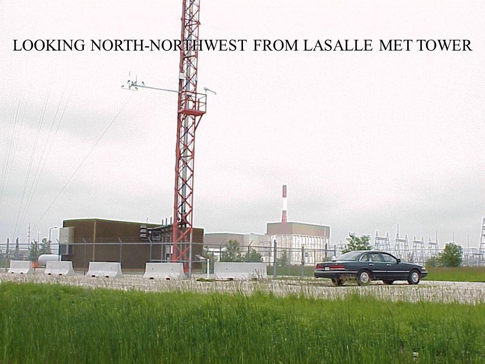
LOOKING NORTH-NORTHWEST FROM LASALLE MET TOWER

71
CROSSARMSHADOW FROM 335° TOWERSHADOW FROM 35-60° 320°335° LA SALLE

72
OLD MET TOWER

73
184 FEET HIGH 133 FEET HIGH LA SALLE

74
10.6 CONTAINMENT HEIGHTS ~1950ft FROM PLANT

77
FOR +3.6M/S

78
Plume spread prior to crossing the Illinois River valley Plume spread after crossing the Illinois River valley LA SALLE

79
Sigma Thetas for LaSalle Impact of containment and plant buildings at all levels (10, 61 and 114 meters) Illinois River topographic effect at all levels
 Illinois River topographic effect at all levels")
80
Study Impacts Met tower siting criteria Site evaluations and maintenance Building wake effects Stability classification for modeling Topographic effects Atmospheric transport Emergency response

85
Preliminary Results from Byron and Quad Cities Sites January - April, 2002

86
Braidwood Illinois Nuclear Plant Locations Zion LaSalle Dresden Byron Quad Cities

87
BYRON

88
BYRON

89
BYRON MET TOWER

90
LOOKING NORTHEAST TO BYRON MET TOWER

91
LOOKING NORTHEAST

92
LOOKING NORTHEAST FROM THE BYRON MET TOWER

93
LOOKING SOUTHEAST FROM THE BYRON MET TOWER

94
BYRON46° 72° TOWERSHADOW FROM 65-85° CROSSARMSHADOW FROM 0°

95
BYRON 200 FEET HIGH 138 FEET HIGH

96
BYRON

97
BYRON 500 FEET HIGH

98
~3700ft FROM PLANT 18.5 CONTAINMENT HEIGHTS BYRON ~4400ft FROM COOLING TOWERS 7.4 COOLING TOWER HEIGHTS

99
PLANT

100
QUAD CITIES

102
MET TOWER

103
QUAD CITIES MET TOWER

104
QUAD CITIES MET TOWER

105
QUAD CITIES MET TOWER

106
TREES QUAD CITIES MET TOWER

107
QUAD CITIES MET TOWER

108
LOOKING SOUTH AT THE QUAD CITIES MET TOWER

109
LOOKING SOUTHWEST AT THE QUAD CITIES MET TOWER

110
LOOKING SOUTH-SOUTHEAST AT THE QUAD CITIES MET TOWER

111
LOOKING NORTHWEST AT THE QUAD CITIES MET TOWER

112
1/4 MILE SOUTHWEST OF THE QUAD CITIES MET TOWER - LOOKING NORTHWEST

113
QUAD CITIES CROSSARMSHADOW FROM 0° TOWERSHADOW FROM 65-85° 350°340°

114
QUAD CITIES 143 FEET HIGH 106 FEET HIGH

115
QUAD CITIES

117
~4800ft FROM PLANT 33.6 CONTAINMENT HEIGHTS

118
PLANT TREES

120
Quad Cities 10-meter Wind Sensors on April 18, 2002 around 1pm

Similar presentations


 Mark T. Carroll Heather A. McDonald Andrew J. Lotz.>")


 Kenneth G. Wastrack Doyle E. Pittman Jennifer M. Call Tennessee Valley Authority.>")


 and Jamie Balstad (First Energy Corp)>")