Download presentation
Presentation is loading. Please wait.

1
James B. McCarthy - County Executive http://www.co.summit.oh.us Summit County Department of Community and Economic Development and The Emergency Management Agency Joe Reichlin - GIS Technical Applications Administrator jreichlin@exec.summitoh.net330-643-8364 GIS Tools for Damage Assessment

2
The Mission: To support the Emergency Operations Center with GIS products when the center is activated, and to provide the EMA with GIS tools for two levels of Damage Assessment. In event of a disaster, one of three EOCs is activated in Summit County. “The Bunker” First Level – A windshield Report which provides a broad picture of the impact and focuses on the severity and magnitude of the disaster. Second Level - A more detailed and comprehensive report that provides in-depth information about public and private damage. Usually a joint effort between local, state, and federal agencies, and the American Red Cross.

3
The Tasks: Gatherings infrastructure data for mapping(existing and to be created) EMA DOD ArcMap Mapping via geocoding, XY coordinates, and manually digitizing DOD ArcMap Centralize infrastructure data DOD SDE Web Development DOD Fiscal EMA ArcIms Quality control using ortho photography EMA DOD ArcMap Web Hardcopy map production DOD ArcMap Future data layers – utilities DOD ArcMap Future use of PDA for damage reporting EMA ARCPAD
 EMA DOD ArcMap Mapping via geocoding, XY coordinates, and manually digitizing DOD ArcMap Centralize infrastructure data DOD SDE Web Development DOD Fiscal EMA ArcIms Quality control using ortho photography EMA DOD ArcMap Web Hardcopy map production DOD ArcMap Future data layers – utilities DOD ArcMap Future use of PDA for damage reporting EMA ARCPAD")
4
Summit County divided into 46 assessment zones

5
Layer wish list

6
Gatherings infrastructure data for mapping via geocoding, XY coordinates, and manually digitizing Descriptive data

7
Standard address geocoding

8
X,Y coordinate data

9
Centralized data in SDE

10
AXL creation in Author and a text editor

11
Generate HTML in Designer

12
Create map service in ArcIMS Administrator

13
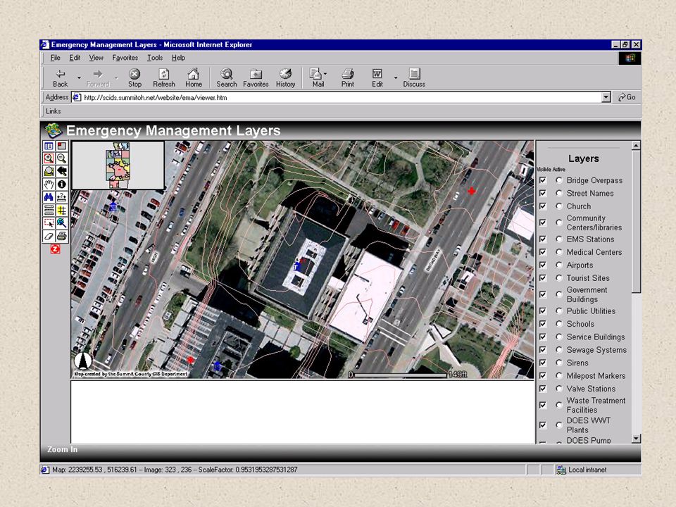
The website

14
Scale dependent layers

16
Quality control on “live data”

17
Large scale, large print maps for EOC “The Bunker”

18
Future layers Utilitie s

19
Future Plans – PDA Personal Data Assistant Mapping and GIS for Mobile Systems ESRI's ArcPad software is mobile mapping and geographic information system (GIS) technology. ArcPad provides database access, mapping, GIS, and global positioning system (GPS) integration to users out in the field via handheld and mobile devices. Data collection with ArcPad is fast, easy, and significantly improved with immediate data validation and availability. What Can You Do with ArcPad? Use your existing data--ArcPad supports industry- standard vector and raster image display. Add data from the Internet--Data can be provided from the Internet via wireless technology. Move around your map--ArcPad includes a number of map navigation tools including zoom and pan, spatial bookmarks, and center on the current GPS position. Query your data--Identify features, display hyperlinks, and locate features. Measure distance, area, and bearings on your ArcPad map. Navigate with your GPS--Connect a GPS and let ArcPad guide you. Edit your data--Create and edit spatial data using input from the mouse pointer, pen, or GPS. Include ArcPad in your GIS solution--Extract, convert, and project your existing data using ArcGIS Desktop or ArcView 3.x.
 integration to users out in the field via handheld and mobile devices. Data collection with ArcPad is fast, easy, and significantly improved with immediate data validation and availability. What Can You Do with ArcPad. Use your existing data--ArcPad supports industry- standard vector and raster image display. Add data from the Internet--Data can be provided from the Internet via wireless technology. Move around your map--ArcPad includes a number of map navigation tools including zoom and pan, spatial bookmarks, and center on the current GPS position. Query your data--Identify features, display hyperlinks, and locate features. Measure distance, area, and bearings on your ArcPad map. Navigate with your GPS--Connect a GPS and let ArcPad guide you. Edit your data--Create and edit spatial data using input from the mouse pointer, pen, or GPS. Include ArcPad in your GIS solution--Extract, convert, and project your existing data using ArcGIS Desktop or ArcView 3.x..")
20
Thank you for your attention Questions and comments

Similar presentations


 An Enterprise GIS for The County of Los Angeles.>")


 Zeng January 19, 2011.>")

 Adding Layers Click.>")


 732-7188 GIS and Mapping Procedures in ArcMap 9.x Creating an ArcMap Project Editing an ArcMap Project Printing an ArcMap Project.>")