Download presentation
Presentation is loading. Please wait.

1
Views of Earth

2
Landforms Common landforms are: Plains Coastal Interior Plateaus
Mountains Folded Upwarped Fault-block Volcanic

3
Plains Plains are large, flat areas of land that have only small changes in elevation. Often have thick, fertile soils Coastal plains are found near the ocean. Kansas is on an interior plain called the Great Plains.

4
Plains Coastal plains form when sediments accumulate on the ocean floor around the continents. Sediments come from rivers dumping material as they enter the ocean. Sediments can also come from erosion of coasts. When the sea level drops due to ocean waters being held as ice in glaciers, the sediments are exposed as flat plains. The coastal plains are also the first areas to become covered by ocean water when glaciers melt and the ocean level rises.

5
Sea Level Rise Map

7
Plateau A plateau is a large, flat area of land that is higher than the surrounding land. Edges rise steeply from land around them. The Colorado Plateau is still rising!

8
Mountain A mountain is a high, natural place on Earth.
Elevation can vary greatly between mountains. There are 4 main types: Folded Upwarped Fault-block Volcanic

9
Folded Mountains Formed from forces inside Earth that have pushed layers of land together, like a throw rug pushed against a wall. The Appalachian Mountains are an example.

10
Upwarped Mountains Blocks of Earth’s crust are pushed up by forces inside Earth. Examples: Adirondacks in New York, Southern Rockies, and the Black Hills of S. Dakota.

11
Fault-Block Mountains
Made of huge, tilted blocks of rock separated from surrounding rock by faults. Examples: Grand Tetons of Wyoming and Sierra Nevada of California n.com/college/geo/a nimations/the_proce ss_of_rifting.htm

12
Volcanic Mountains Form when molten material reaches the surface of Earth through a weak area in the crust. Molten material can gradually build up into a mountain shape. Examples: Mount Rainier in Washington, Mount Shasta in California, Mauna Loa in Hawaii

13
Volcanic Mountains

14
Canyon A canyon is a deep valley with very steep sides—often carved from Earth by a river. Grand Canyon, Arizona is an example of a very large canyon.

15
A mesa is a land formation with a flat area on top and steep walls - usually occurring in dry areas.
Smaller than a plateau. This one is in Arizona. Mesa

16
Sea Level Sea Level is the average height, or elevation of where the sea surface meets the land.

17
Valley A valley is a low place between mountains.

18
Glacier A glacier is a slow-moving river of ice.
There are valley glaciers and continental glaciers. Some glaciers even float in the ocean.

19
VIEWPOINTS To pinpoint a location on Earth, mapmakers use a series of gridlines—or coordinates. These coordinates are made up of: Lines of latitude—lines that run around the Earth, parallel to the equator. Lines of longitude—lines that run from pole to pole. The lines are divided by degrees. There are 360 degrees in a circle (Earth). Each degree is divided into 60 minutes. Each minute is divided into 60 seconds.
. Each degree is divided into 60 minutes. Each minute is divided into 60 seconds.")
20
LATITUDE Used to measure distances north and south in degrees
The equator divides the earth into a northern and southern half or hemisphere. Lines of latitude start at the equator and go north to the north pole (¼ of the way around the earth) to 90 degrees. Lines also go south of the equator to the south pole (also ¼ of the way around the earth) to 90 degrees.
 to 90 degrees. Lines also go south of the equator to the south pole (also ¼ of the way around the earth) to 90 degrees.")
21
LINES OF LATITUDE 90°N 0° 90°S

22
LONGITUDE Begins at the prime meridian (0 degrees), which cuts pole-to-pole through Greenwich, England Points west of Greenwich are measured from 0 to 180 degrees to the other side of Earth going west. Points east of Greenwich are measured from 0 to 180 degrees to the other side of Earth going east. There are 360 degrees in a circle, so both halves add up to 360.

24
LINES OF LONGITUDE 0°

25
PRIME MERIDIAN v. EQUATOR
The prime meridian does not circle Earth. It goes from pole-to-pole through Greenwich England, but does not go from pole-to-pole on the other side. The other side of the earth is 180 degrees. The equator DOES circle Earth—all the way around its “belly.” The lines of latitude measure north and south and are like rungs of a ladder (lat-itude, lad-der). Lines of longitude measure east and west from the Prime Meridian.
. Lines of longitude measure east and west from the Prime Meridian.")
26
TIME ZONES The earth is like a big clock. But it’s a 24-hour clock, not a 12-hour clock! That’s because each day takes 24 HOURS. There are 24 time zones around the world, which divide the earth into a clock. The International Date Line is where the Earth-clock starts each new day, and the rest of the world follows. The IDL is really close to the 180 degree line of longitude. Time zones are not perfectly arranged. People have adjusted them somewhat to suit themselves. Go figure!

27
24 1 23 2 22 The 24 hour spot is one hour ahead of the next spot west, since Earth rotates to the east. 3 21 4 20 5 19 Direction of Earth’s Rotation 6 18 7 17 8 16 9 15 14 10 11 13 12

28
MAPS Maps help you tell where you are and where you are going.
Map projections are made when points and lines on a globe’s surface are transferred onto paper. All flat maps have some type of distortion. There are 3 types of map projections Mercator Projection Robinson Projection Conic Projection

29
Mercator Projection Used mainly on ships
Advantages of using this kind of map: Shows correct shapes of continents. Disadvantages: Areas of continents are distorted. Lines of longitude appear parallel (when they really aren’t). This makes the poles appear larger. Greenland looks larger than S. America (which it is not).
. This makes the poles appear larger. Greenland looks larger than S. America (which it is not).")
30
Mercator Projection

31
Robinson Projection Shows accurate continent shapes and more accurate land areas Lines of latitude are parallel (as they should be). Lines of longitude are curved (as they should be). Less distortion near poles.
. Less distortion near poles.")
32
Robinson Projection

33
Conic Projection Road maps and weather maps are conic projections.
Used to produce maps of small areas Made by projecting points and lines from a globe onto a cone.

34
Weather Maps

35
Conic Projections

36
How a Conic Projection is Made

37
Conic Projection: Road Map

38
Other Maps: Interrupted Projection

39
Other Maps: Plane Projection

40
Other Maps: Cylindrical Projection

41
Other Maps: Sea surface temperature maps

42
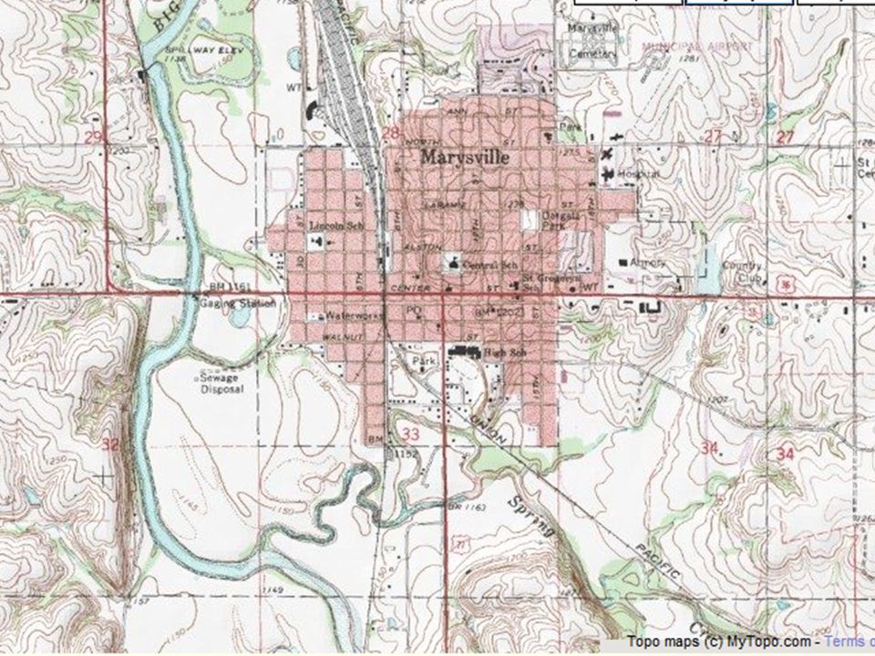
Topographic Maps Show the changes in elevation of Earth’s surface.
Used by land developers, hikers, and farmers to see how they need to work with the rise and fall of the land Use connected lines to show changes in elevation. The closer the lines, the steeper the slopes. Lines cannot cross one another because one continuous line is always at the same elevation.

45
Another Look at Topographic Maps
Click here

46
Finding Elevation

47
Map Terms Map Scale—the relationship between the distances on the map and real distances on Earth’s surface Map Legend—explains what the symbols used on the map mean. Compass or compass rose—shows the directions on the map. North is usually toward the top.

48
Legend Compass Rose Scale

49
Geologic Maps Show cross sections of Earth so we can visualize what is under the surface Geologists determine what is below the surface by drilling into rock and soil to get core samples

50
3-Dimensional Maps Google Earth is a good example of a 3-D map.

51
Remote Sensing Remote sensing is any technology that can be used to create maps, without having to physically touch the territory being described. These remote sensing technologies are often deployed from a plane or satellite.

52
Landsat and Other Satellite Imagery
Satellites circle Earth collecting imagery and other data for weather for climate change for spying for geologic changes for mapmaking

53
Some Satellite Images

54
GPS Stands for Global Positioning System
Uses at least 3 satellites (out of 24) to triangulate your location. Triangulation involves pinpointing the exact location of where the 3 satellites’ data (or more) intersect one another. orks/38-how-gps-works-video.htm
 to triangulate your location. Triangulation involves pinpointing the exact location of where the 3 satellites’ data (or more) intersect one another. orks/38-how-gps-works-video.htm.")
Similar presentations