Download presentation
Presentation is loading. Please wait.

1
Jeff Blossom Senior GIS Specialist Center for Geographic Analysis, Harvard University March 18, 2009 Geographic Information Systems and CGA’s Services and Workshops Presentation for the Fellowship in General Medicine and Primary Care

2
Overview Geographic Information Systems Geographic Information Systems CGA’s Services CGA’s Services CGA’s Training Workshops CGA’s Training Workshops Sample Projects Sample Projects

3
Geographic Information Systems (GIS) Geography – The study of where features are located on the Earth’s surface. Geographic coordinate systems latitudelongitude - Represent exact positions on the Earth - 42.3216, -71.089118 (lat. long. for Boston) Georeferencing / Geocoding – The process of assigning geographic coordinates to features to represent their location.
 Georeferencing / Geocoding – The process of assigning geographic coordinates to features to represent their location..")
4
Geographic Information Systems (GIS) Geographic feature representation: points, lines, polygons, rasters. Points – U.S. Cities Lines – U.S. Interstates Polygons – U.S. States

5
Geographic Information Systems (GIS) Geographic feature representation: points, lines, polygons, rasters. Raster – Boston aerial photo

6
Geographic Information Systems (GIS) Information about the geographic features – stored in tabular form Points – U.S. Cities Lines – U.S. Interstates Polygons – U.S. States

7
Geographic Information Systems (GIS) Raster – Boston aerial photo
 Raster – Boston aerial photo")
8
Geographic Information Systems (GIS) A collection of computer hardware, software, and geographic data designed for capturing, storing, updating, manipulating, analyzing, and displaying all forms of geographically referenced information. - Hardware - Software - Data - Methodology - People - Management

9
2. A set of tools and procedures – A language to perform tasks 1. Smart, interactive, functional Map DBMS 3. A well-managed system of information Data Files Three views of GIS

10
Visualization: many different ways Maps digital, web Maps digital, web Tables database driven Tables database driven Charts auto update Charts auto update Reports embedded Reports embedded Photos linked Photos linked 3-D animation 3-D animation Multi-media presentation Multi-media presentation

11
CGA Basic Services Maintaining help desks in both campuses; Maintaining help desks in both campuses; Consulting with students, faculty, and staff on research and teaching projects; Consulting with students, faculty, and staff on research and teaching projects; Consulting on grant proposals; Consulting on grant proposals; Providing non-credit group instruction in geospatial software applications on a regular basis; Providing non-credit group instruction in geospatial software applications on a regular basis; Assessing, organizing, financing for, and maintaining university site licenses for software; Assessing, organizing, financing for, and maintaining university site licenses for software; Providing hardware and support for geospatial tools; Providing hardware and support for geospatial tools; Undertaking initiatives that improve the university infrastructure in relation to geographic analysis. Undertaking initiatives that improve the university infrastructure in relation to geographic analysis.

12
Research Consultation Data issues, e.g. Data issues, e.g. Public and commercial data sourcesPublic and commercial data sources Data collection and management techniquesData collection and management techniques Data conversion, scanning, digitizing, etc.Data conversion, scanning, digitizing, etc. Hardware/software issues, e.g. Hardware/software issues, e.g. What GPS to buy – accuracy, compatibility, etc.What GPS to buy – accuracy, compatibility, etc. Which software to use for various tasksWhich software to use for various tasks Methodology issues, e.g. Methodology issues, e.g. How to select parameters in spatial interpolationHow to select parameters in spatial interpolation How to build location-allocation modelsHow to build location-allocation models Visualization issues, e.g. Visualization issues, e.g. How to do 3-D maps or time-series animationHow to do 3-D maps or time-series animation How to allow users make interactive maps from a web browserHow to allow users make interactive maps from a web browser

13
Washington Life Expectancy Mapping and Visualization

14
Indian Physician Migration

15
Quantifying air pollution in Accra, Ghana

17
Health Clubs per Census Tract

18
HealthMap.org

19
Nationalatlas.gov

20
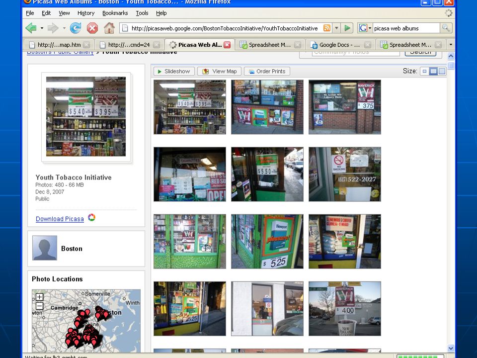
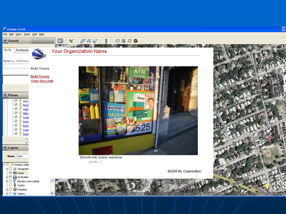
Youth Tobacco Initiative

24
Instructional Service Semester courses in Faculty of Arts and Sciences Semester courses in Faculty of Arts and Sciences Winter recess courses in Harvard Medical School and Harvard School of Public Health Winter recess courses in Harvard Medical School and Harvard School of Public Health Non-credit GIS training seminars Non-credit GIS training seminars Customized GIS course modules in various courses (e.g. history, business, health, government) Customized GIS course modules in various courses (e.g. history, business, health, government) Extension school courses in GIS Extension school courses in GIS Online tutorials and self-learning materials Online tutorials and self-learning materials
 Customized GIS course modules in various courses (e.g. history, business, health, government) Extension school courses in GIS Extension school courses in GIS Online tutorials and self-learning materials Online tutorials and self-learning materials.")
25
GIS Workshops Designed to introduce GIS concepts and teach basic GIS software use. Designed to introduce GIS concepts and teach basic GIS software use. 2 hours of instructor led, hands on training. 2 hours of instructor led, hands on training. 4 workshops, offered 3x per year in Cambridge and Longwood. 4 workshops, offered 3x per year in Cambridge and Longwood. Available to anyone with Harvard ID Available to anyone with Harvard ID Register online at: Register online at: http://gis.harvard.edu/icb/icb.do?keyword=k235&pageid=icb.page189848

26
GIS Workshop: Intro to GIS Brief introduction to GIS- related terminology and spatial data basics. Brief introduction to GIS- related terminology and spatial data basics. Students create a basic map using ArcGIS, and MassGIS data. Students create a basic map using ArcGIS, and MassGIS data.

27
GIS Workshop: Wrangling Data into Maps Covers techniques and methods of converting different data types from various sources into a map. Covers techniques and methods of converting different data types from various sources into a map. Students create a map of publishable quality from geo-coded, tabular, text, and online data. Students create a map of publishable quality from geo-coded, tabular, text, and online data.

28
GIS Workshop: Getting the most out of Google Earth Hands-on exploration of the extensive functionality of Google Earth including navigation, feature creation, and map georefererencing. Hands-on exploration of the extensive functionality of Google Earth including navigation, feature creation, and map georefererencing. Import/Export of data from/to ArcMap. Import/Export of data from/to ArcMap.

29
GIS Workshop: Making Sense of Spatial Data An introduction to spatial analysis for various kinds of problem solving in a GIS environment. An introduction to spatial analysis for various kinds of problem solving in a GIS environment. Students work with raster and vector data, performing spatial operations like overlay, buffering, and interpolation. Students work with raster and vector data, performing spatial operations like overlay, buffering, and interpolation.

30
GIS Workshop: Intro to Google Maps mashups (Fall of 2009) How to perform online mapping and publish results on a website. How to perform online mapping and publish results on a website. Embedding a custom Google Map on a website. Embedding a custom Google Map on a website.

31
GIS Workshop: Global Positioning System Mapping A hands on workshop that will introduce the concept and various uses of the Global Positioning System (GPS). A hands on workshop that will introduce the concept and various uses of the Global Positioning System (GPS). Students will use mapping GPS devices in the field, and upload the mapped data into desktop and internet mapping applications. Students will use mapping GPS devices in the field, and upload the mapped data into desktop and internet mapping applications. Intended for students / researchers who plan to use GPS for their field work. Intended for students / researchers who plan to use GPS for their field work.
. Students will use mapping GPS devices in the field, and upload the mapped data into desktop and internet mapping applications. Students will use mapping GPS devices in the field, and upload the mapped data into desktop and internet mapping applications. Intended for students / researchers who plan to use GPS for their field work. Intended for students / researchers who plan to use GPS for their field work..")
32
Thank You Credits: This presentation includes material provided by the Center for Geographic Analysis, Harvard University, Harvard School of Public Health, Harvard Medical School, Environmental Systems Research Institute, Garmin, Warigia Bowman, and Google. Jeff Blosssom Contact: jblossom@cga.harvard.edu Website: http://gis.harvard.edu jblossom@cga.harvard.edu Geocoding and mapping: Geocoding and mapping: http://www.batchgeocode.com http://www.batchgeocode.comwww.batchgeocode.com http://maps.google.com http://maps.google.com http://maps.google.com http://maps.yahoo.com http://maps.yahoo.com http://earth.google.com http://earth.google.com Public Health: Public Health: http://www.nationalatlas.gov http://www.nationalatlas.gov http://www.nationalatlas.gov http://healthmap.org http://healthmap.org http://healthmap.org http://healthlandscape.org http://healthlandscape.org http://healthlandscape.org Surgical Safety website: http://cga2.cga.harvard.edu:8080/KML/Surgical_Safety.htm

Similar presentations


.>")


 Librarian GIS in.>")


 Fundamentals for Program Managers.>")

 integrates hardware, software, and data for capturing, managing,>")


