Download presentation
Presentation is loading. Please wait.

1
PRNFC SAFETY STANDDOWN
Navy Flying Club Safety Brief May 10, 2005

2
SAFETY BRIEF SCHEDULE May 2005: Spring Safety Stand-Down
July 2004: Communications Failure August 2004: In-Flight Emergencies September 2004: Bird-Strike Hazards October 2004: Cold Weather Operations November 2004: Fall Safety Stand-Down December 2004: ADIZ Procedures January 2005: No Briefing February 2005: FAA Safety Seminar/Briefing March 2005: Aviation Physiology April 2005: No Briefing May 2005: Spring Safety Stand-Down June 2005:

3
Airspace Classes FL 600 18,000 MSL CLASS A CLASS E CLASS B CLASS C
(Above 18,000’) 18,000 MSL CLASS E (Everything Else) CLASS B (Big apt) CLASS C (mode C) CLASS D (Dashed line) 1200’ AGL 700’ AGL CLASS G (near Ground) CLASS G CLASS G
 18,000 MSL. CLASS E. (Everything Else) CLASS B. (Big apt) CLASS C. (mode C) CLASS D. (Dashed line) 1200’ AGL. 700’ AGL. CLASS G. (near Ground) CLASS G. CLASS G.")
4
Airspace - VFR Requirements
FL 600 CLASS A (Above 18,000’) IFR only 18,000 MSL CLASS E (Above 10,000’) F-111 Five statute miles 1000’ Above 1000’ Below 1 mi. Horizontal 10,000 MSL CLASS E (Below 10,000’) 3-152’s 3 statute miles 1000’ Above 500’ Below 2000’ Horizontal CLASS B 3 mi, clear of clouds CLASS C 3-152’s CLASS D 3-152’s 1200’ AGL 700’ AGL CLASS G Day: 1 mi, clear of clouds CLASS G CLASS G Night: 3-152’s
 IFR only. 18,000 MSL. CLASS E. (Above 10,000’) F-111. Five statute miles. 1000’ Above. 1000’ Below. 1 mi. Horizontal. 10,000 MSL. CLASS E. (Below 10,000’) 3-152’s. 3 statute miles. 1000’ Above. 500’ Below. 2000’ Horizontal. CLASS B. 3 mi, clear. of clouds. CLASS C ’s. CLASS D ’s. 1200’ AGL. 700’ AGL. CLASS G. Day: 1 mi, clear of clouds. CLASS G. CLASS G. Night: 3-152’s.")
5
Class A Airspace Begins at 18,000 feet MSL up to FL600
Instrument Flight Plan, Mode C Transponder and IFR Clearance Required VFR Weather Minimums not applicable

6
Class B Airspace Clearance required to enter Required Equipment
2-way radio Mode C Transponder VOR or TACAN (IFR only) VFR Weather Minimums 3 statute miles, clear of clouds
 VFR Weather Minimums. 3 statute miles, clear of clouds.")
7
Class C Airspace Establish 2-way radio communication before entering
Required Equipment 2-way radio Mode C Transponder VFR Weather Minimums: 3-152’s 3 s.m., 500’ below, 1000’ above, 2000’ Horizontal

8
Class D Airspace Need operating control tower to be in effect
2-way radio comm. required before entering Extends 4.4 nm (5 sm) radius from airport Extends up to, not including 2,500’ AGL other altitudes may apply VFR Weather Minimums: 3-152’s 3 s.m., 500’ below, 1000’ above, 2000’ Horizontal
 radius from airport. Extends up to, not including 2,500’ AGL. other altitudes may apply. VFR Weather Minimums: 3-152’s. 3 s.m., 500’ below, 1000’ above, 2000’ Horizontal.")
9
Class E Airspace Everything except A, B, C, D and G airspace
Normally extends from 1200’ to 18,000’ magenta bar indicates floor of 700’ magenta dashed line indicates floor to surface VFR Minimums (below 10,000’): 3-152’s 3 s.m., 500’ below, 1000’ above, 2000’ Horizontal VFR Minimums (above 10,000’): F-111 5 s.m., 1000’ below, 1000’ above, 1 s.m. Horizontal
: 3-152’s. 3 s.m., 500’ below, 1000’ above, 2000’ Horizontal. VFR Minimums (above 10,000’): F s.m., 1000’ below, 1000’ above, 1 s.m. Horizontal.")
10
Class G Airspace VFR Weather Minimums (day)
1 statute mile, clear of clouds VFR Weather Minimums (night): 3-152’s 3 s.m., 500’ below, 1000’ above, 2000’ Horizontal Other VFR min. apply above 1200’ AGL
: 3-152’s. 3 s.m., 500’ below, 1000’ above, 2000’ Horizontal. Other VFR min. apply above 1200’ AGL.")
11
VFR Weather Minimums Usually 3-152’s
3 s.m., 500’ below, 1000’ above, 2000’ Horizontal VFR Weather Min. other than 3-152’s Class A: IFR only Class B: 3 statute miles, clear of clouds Class E (above 10,000’): F-111 Class G (day): 1 statute mile, clear of clouds Special VFR: 1 s.m., clear of clouds
: F-111. Class G (day): 1 statute mile, clear of clouds. Special VFR: 1 s.m., clear of clouds.")
12
Mode C Transponder Required
Class A, B, and C Within 30 n.m. of Class B (mode C veil) Above Class B, Above Class C Above 10,000’ MSL and above 2500’ AGL Into or Across U.S. ADIZ 10nm apt in FAR Part 91, Apndx D Sect 2 In all controlled airspace if equipped
 Above Class B, Above Class C. Above 10,000’ MSL and above 2500’ AGL. Into or Across U.S. ADIZ. 10nm apt in FAR Part 91, Apndx D Sect 2. In all controlled airspace if equipped.")
13
Permission Required to Enter
Prohibited Area Permission Required to Enter Always Active

14
Restricted Area Activities
Artillery Aerial Gunnery Guided Missiles If active, permission from controlling agency required to enter

15
Warning Area Activities
Artillery Aerial Gunnery Guided Missiles Located outside 3 mi. limit, over international water Permission not required to enter, but Exercise Extreme Caution

16
Military Operating Area
Aerobatic flying and abrupt maneuvers Purpose: Separate IFR and military traffic FSS within 100 nm can provide info. Permission is not required to enter MOA

17
Alert Area Activities Exercise caution when operating in an Alert Area
High volume of pilot training Unusual aerial activity Exercise caution when operating in an Alert Area Permission is not required to enter an Alert Area

18
FAR’s - Speed Restrictions
Aircraft may not exceed 250 knots below 10,000 feet MSL (unless authorized by the FAA Administrator) Aircraft may not exceed 200 knots below a Class B Airspace (Terminal Control Area) Unless authorized or required by ATC, aircraft may not exceed 200 knots within an Class D Airspace (Airport Traffic Area)
 Aircraft may not exceed 200 knots below a Class B Airspace (Terminal Control Area) Unless authorized or required by ATC, aircraft may not exceed 200 knots within an Class D Airspace (Airport Traffic Area)")
19
FAR’s - Seat Belts Pilot must wear seat belt and shoulder harness (if equipped) while at duty station pilot may remove shoulder harness if unable to perform required duties All passengers must wear seat belt and shoulder harness (if equipped) during takeoff and landing
 during takeoff and landing.")
20
FAR’s - Aircraft Documents
A = Airworthiness Certificate R = Registration Certificate R = Radio Operating License (no longer required in USA, Canada) O = Operating Limitations W = Weight and Balance These documents must be on board the aircraft during all periods of operation.
 O = Operating Limitations. W = Weight and Balance. These documents must be on board the. aircraft during all periods of operation.")
21
Emergency Locator Transmitter (ELT)
ELT’s transmit on and Mhz Test/inspection required every 12 months Only during the first 5 minutes of every hour Limited to 3 audio sweeps Battery Must be marked with an expiration date Must be replaced after 1 hour cumulative use or after 1/2 battery life has expired

22
Oxygen Requirements Non-Pressurized Aircraft
12, ,000 feet MSL Flight crew must use oxygen for all portions of flight over 30 minutes between these altitudes Above 14,000 feet MSL Flight crew must use oxygen at all times Above 15,000 feet MSL All passengers must be provided with oxygen

23
Medical Certificates Medical certificates expire the last day of the month of expiration Privileges ATP Commercial Private Pilot Student Pilot 1st Class 6 months 2nd Class N/A 12 months 3rd Class N/A 24/36 months Private/Student certificates good for 36 months if pilot < 40 on exam date.

24
Aerobatic Flight Not allowed Below 1,500 feet AGL
Flight visibility less than 3 statute miles Within Class B, C or D Airspace Within Class E Airspace designated for an apt. On federal airways Over congested areas Over open assemblies of people

25
Pilot Currency Required for Passenger Transportation
Within the past 90 days Same category and class Daytime Three takeoffs and landings Conventional Landing Gear (Taildragger) Three takeoffs and landings to full stop Nighttime
 Three takeoffs and landings to full stop. Nighttime.")
26
Night Flight Night - Definition:
the time between the end of evening civil twilight and the beginning of morning civil twilight, as published in the American Air Almanac, converted to local time Twilight ends/begins when the center of the sun’s disk is 6 degrees below the horizon In Florida, min after/before sunset/rise In Maine, min after/before sunset/rise

27
Night Flight Position lights required from sunset to sunrise
Currency requirements for passenger transportation at night During the period from 1 hour after sunset to 1 hour before sunrise Within preceding 90 days Three takeoffs, three landings to a full stop Same category and class aircraft

28
Special VFR Class D & E Airspace, some Class B & C Required for SVFR
Ceiling Below 1,000’ AGL Visibility Less then 3 miles Required for SVFR 1 statute mile visibility, clear of clouds Required for SVFR at night Pilot must be instrument rated Aircraft must be instrument equipped

29
Transponder Codes 7700 = Emergency 7600 = Lost communications
7500 = Hijack 1200 = Standard VFR 7777 = Military interceptor operations 4000 = Military in restricted/warning areas 0000 = Target drones

30
Maintenance All aircraft must have an Annual Inspection
Commercial aircraft must have 100 hr insp. Transponder check every two years Pitot/Static check every two years (IFR) ELT Battery replacement every two years ELT Inspection every 12 calendar months AD compliance mandatory
 ELT Battery replacement every two years. ELT Inspection every 12 calendar months. AD compliance mandatory.")
31
Required Equipment (VFR)
T = Tachometer O = Oil Pressure Gauge M = Magnetic Compass A = Altimeter T = Temp. Gauge (if liquid cooled) O = Oil Temperature Gauge
 O = Oil Temperature Gauge.")
32
Required Equipment (VFR)
F = Fuel Gauge For Each Tank L = Landing Gear Position Indicator A = Airspeed Indicator M = Manifold Pressure Indicator E = Emergency Locator Transmitter S = Seat Belts (>=2 years old)
")
33
Required Equipment (Night VFR)
F = Fuses (Spare Set or 3 of Each Type) L = Landing Light (Commercial Ops.) A = Anti-Collision Light P = Position Lights S = Source of Electrical Power
 L = Landing Light (Commercial Ops.) A = Anti-Collision Light. P = Position Lights. S = Source of Electrical Power.")
34
ATC Light Signals

35
Minimum Altitudes 1,000’ above, 2,000’ horizontal from any object over congested area 500’ above non-congested area Sparsely populated area, 500’ from any person vessel property

36
VFR Cruising Altitudes
Based upon magnetic course, not magnetic heading Starts at 3,000 feet AGL 0°-179° maintain odd thousands plus 500’ MSL 180°-359° maintain even thousands plus 500’ MSL Remember “Odd Geese Fly East”

37
Right of Way Aircraft in distress has ROW over all others
Balloon has ROW over any aircraft Glider has ROW over airships, airplanes and rotorcraft Airship has ROW over airplanes, rotorcraft

38
Right of Way When two aircraft are approaching head on, both should turn to the right When two aircraft (same category) are converging, the one on the others right has the ROW An aircraft being overtaken has the ROW While landing, the lowest aircraft has ROW
 are converging, the one on the others right has the ROW. An aircraft being overtaken has the ROW. While landing, the lowest aircraft has ROW.")
39
Pre-Flight Action Pilot must be free from alcoholic beverages for eight hours prior to flight “Eight hours from bottle to throttle” Pilot must acquire current and forecast weather Pilot must check runway lengths of the destination airport

40
Pre-Flight Action Pilot must have alternate course of action if flight can not be completed to destination Pilot must check if there are ATC delays Pilot must concern herself with all available information regarding the flight

41
Fuel Requirements VFR Daytime VFR Nighttime IFR
Fuel to destination plus 30 minutes VFR Nighttime Fuel to destination plus 45 minutes IFR Fuel to destination or alternate apt. if required plus 45 minutes IFR Alternate Airport not required if, 1 hour before/after, more than 2000’ and 3 sm visibility

42
Hyperventilation Hyperventilation: an excessive increase in breathing rate or depth Occurs as a result of Emotional tension Anxiety Apprehension

43
Hyperventilation Symptoms Can lead to unconsciousness
Sensation of being warm Nausea Tingling of fingers and toes Muscle spasms Can lead to unconsciousness

44
Hyperventilation Treatment
Try to get the person to breathe slowly Breathe into a paper bag Try to re-establish proper amount of carbon dioxide in the blood

45
Vertigo Caused by loss of visual references
Leads to spatial disorientation Overcome vertigo by relying on the flight instruments

46
Hypoxia Occurs when an insufficient quantity of oxygen is available in the blood Symptoms occur at approx. 10,000 feet Symptoms at lower altitudes for Heavy smokers People in poor physical condition Hypoxia can lead to unconsciousness

47
Hypoxia The most dangerous symptom is a feeling of well being
Treatment Provide supplemental oxygen Descend to a lower altitude

48
METAR/TAF METAR TAF Aviation Routine Weather Report
replaces Surface Aviation Observation (SA) TAF Aerodrome Forecast replaces Terminal Forecast (FT)
 TAF. Aerodrome Forecast. replaces Terminal Forecast (FT)")
50
Sigmet Significant Meteorology Available from FAA and HIWAS stations
Severe/Extreme turbulence Severe Icing Widespread dust and sandstorms with visibility less than three miles Available from FAA and HIWAS stations

51
Convective Sigmet Tornadoes Lines of thunderstorms
Embedded thunderstorms Intense thunderstorms affecting 40% or more of area of at least 3,000 square feet Hail 3/4 of and inch or greater in diameter

52
Airmet Concerns small aircraft and aircraft with lack of instruments or equipment Airmet covers Moderate icing & severe turbulence over an extensive area Extensive area of visibility less then 3 miles and/or ceilings lower then 1,000’ Winds 30 kts or more within 2,000’ of surface

53
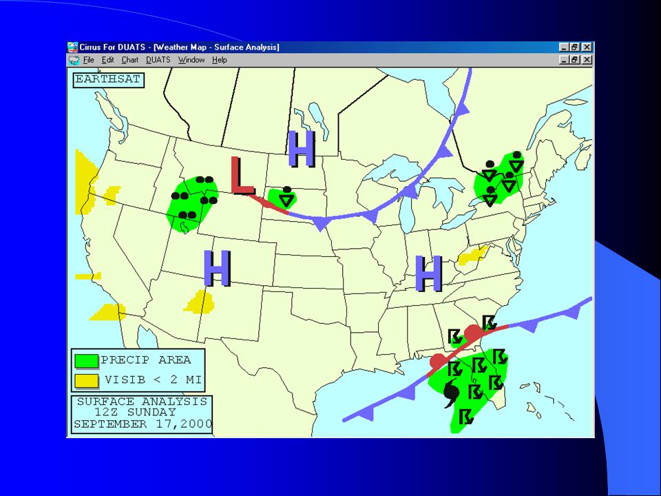
Surface Analysis Chart
Issued every three hours Provides a general picture of atmospheric pressure patterns by showing highs, lows and fronts

55
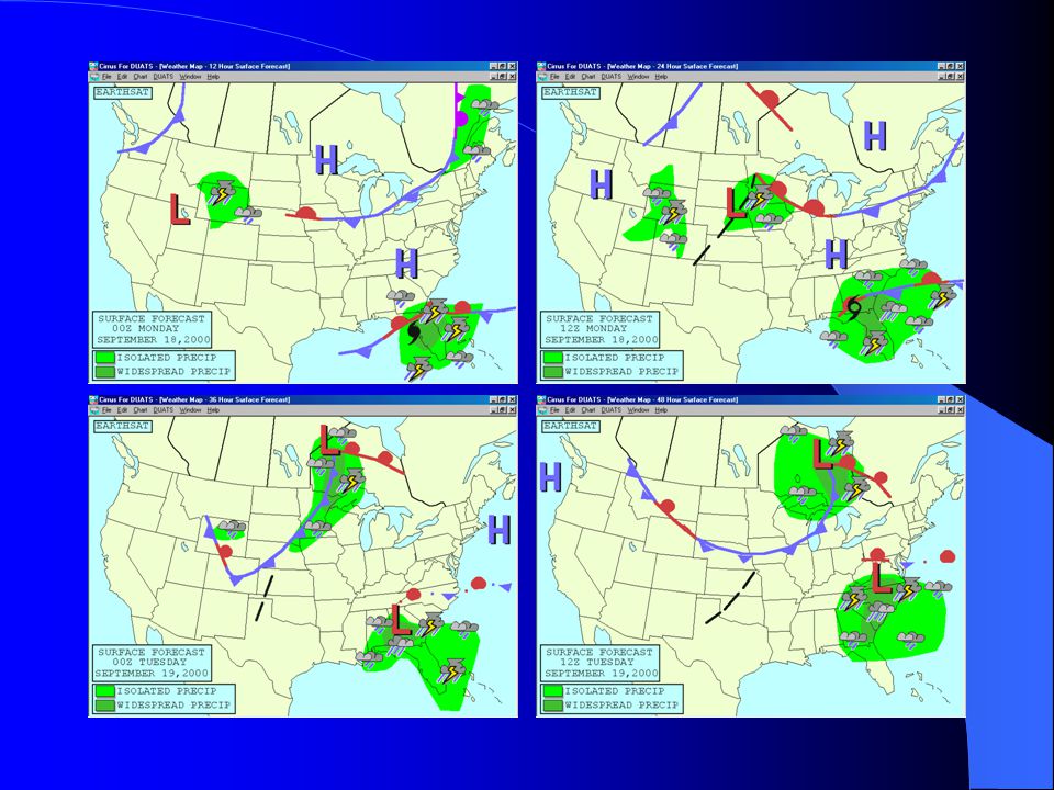
Surface Forecast Chart
Issued four times a day Forecast of Surface Analysis Chart Provides a general picture of atmospheric pressure patterns by showing highs, lows and fronts

57
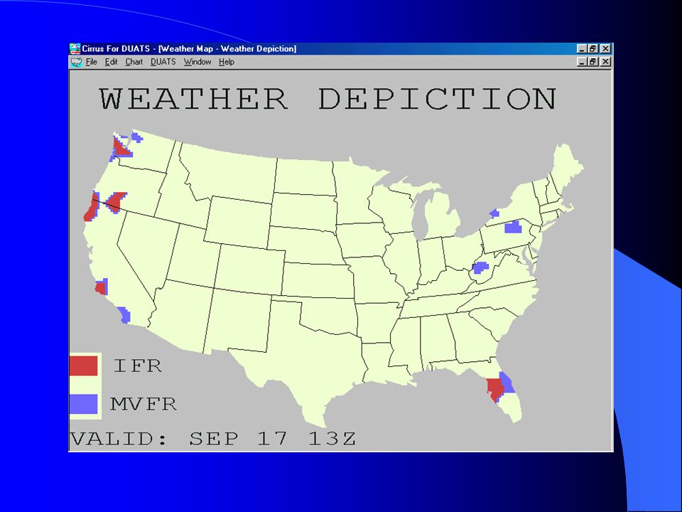
Weather Depiction Chart
Issued every three hours Provides a picture of areas with IFR MVFR VFR

59
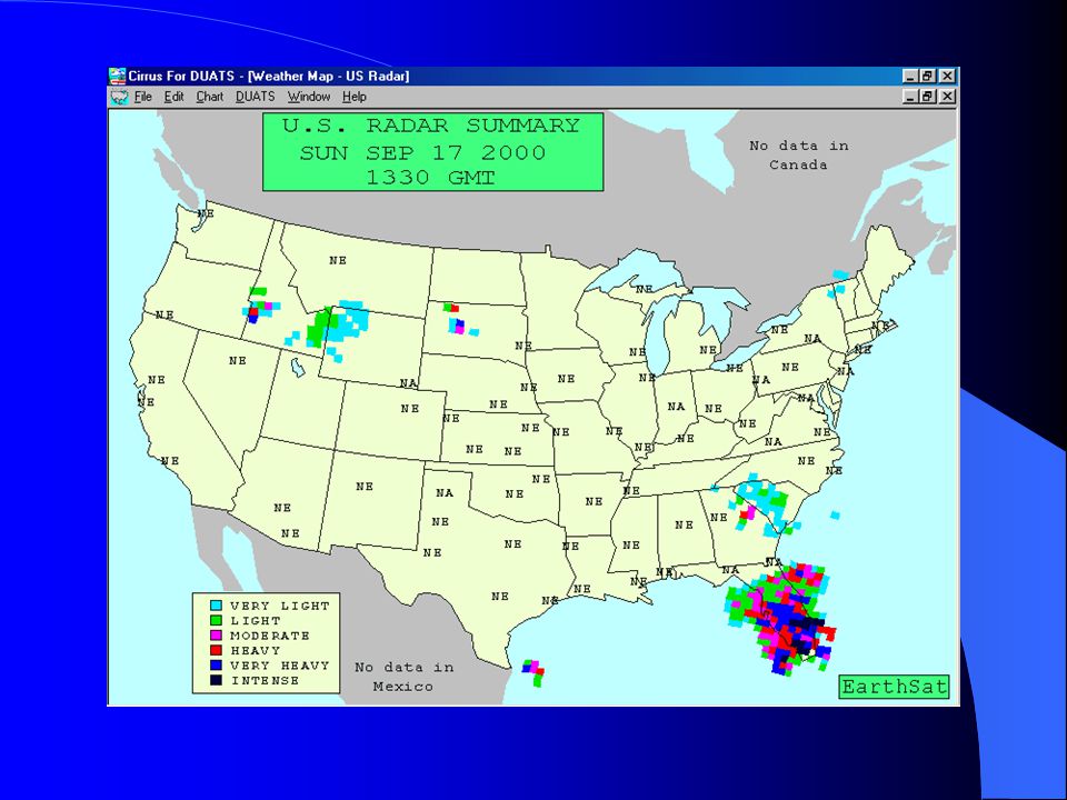
Radar Summary Chart Normally issued every hour
Provides location and movement of thunderstorms, tornadoes, hurricanes and their intensity Shows weather associated with rain, hail, icing and turbulence

61
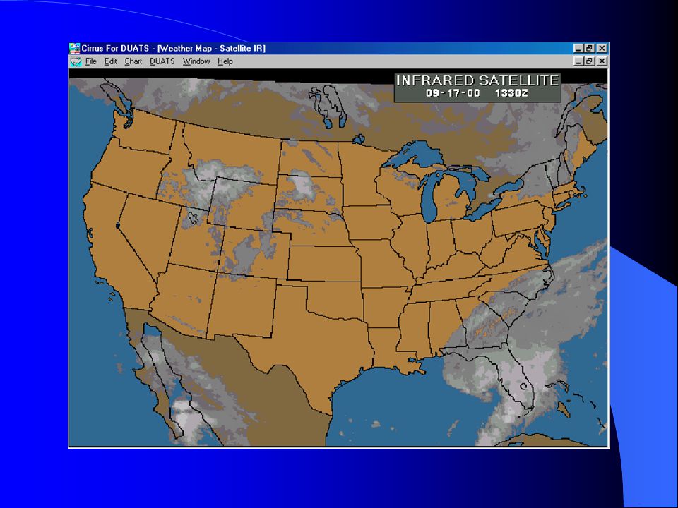
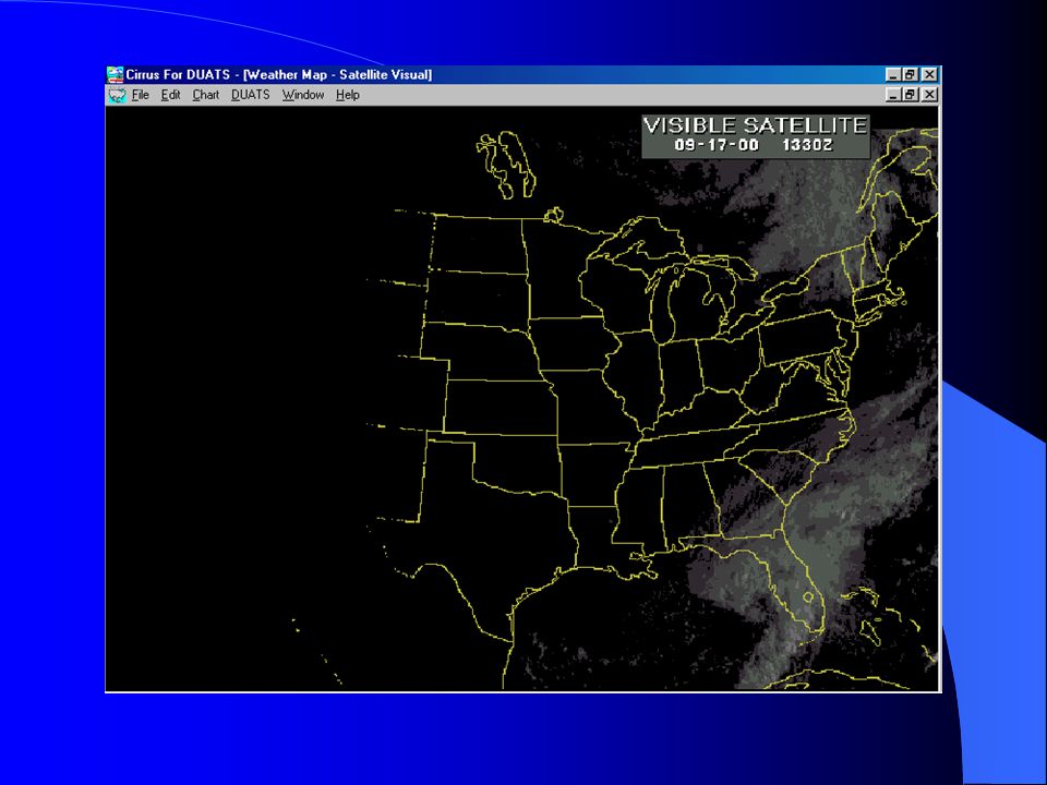
Satellite Weather Views
Issued every hour Available on DUATS Infrared available 24 hours/day Visual available during daylight hours

64
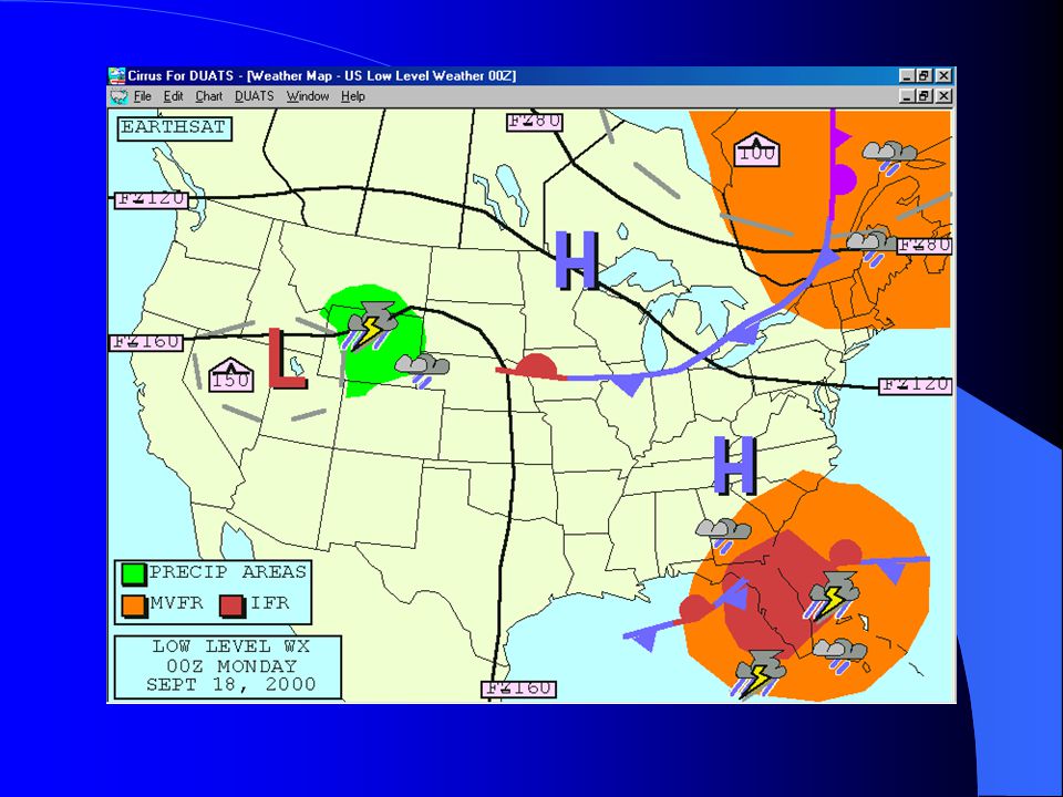
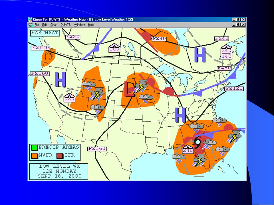
Low Level Weather Issued every six hours Provides freezing levels
areas and levels of turbulence locations of fronts pressure systems areas of precipitation VFR/MVFR/IFR areas

67
QUESTIONS?

Similar presentations