Download presentation
Presentation is loading. Please wait.

1
Ongoing Developments In Weather Forecasting System In India Meteorological Department S.R. Kalsi INDIA METEOROLOGICAL DEPARTMENT NEW DELHI

2
OUTLINE Conventional Observational Networks Radar & Satellite Systems Forecast System Warning Dissemination Systems Future Plans

3
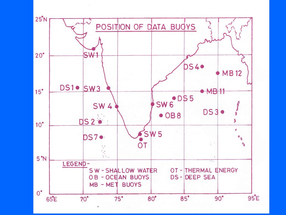
IMD’S OBSERVATIONAL NETWORK SURFACE OBSERVATORIES556 HWSRs 20 UPPER AIR OBSERVATORIES 110 S-BAND CONVENTIONAL RADARS 8 DOPPLER WEATHER RADARS 4 INSAT-2E/METSAT/NOAA/METEOSAT SATELLITES SHIPS OF INDIAN VOLUNTARY OBSERVING FLEET 207 BUOYS 13

4
Surface Observations

5
Upper Air Network Radiosonde Pilot Balloon

6
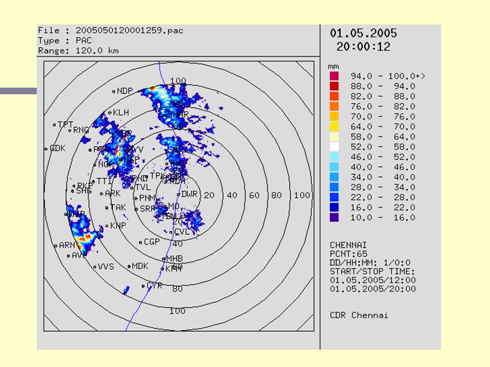
Radar Network X-Band Radars Thunderstorm warning S-Band Radars Cyclone warning

7
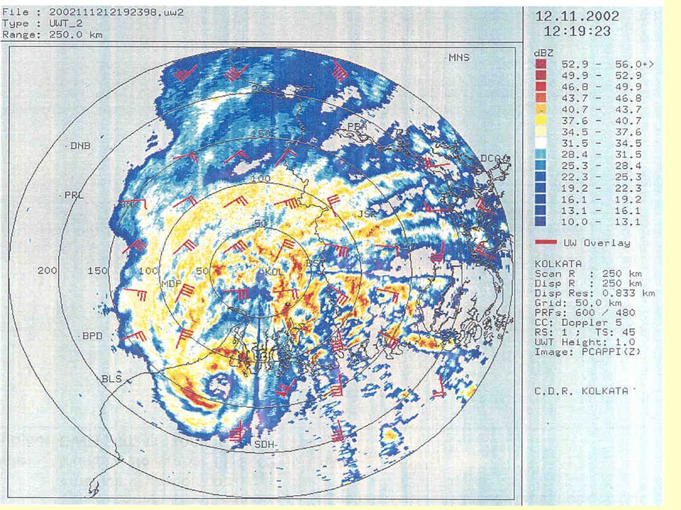
Vertical profile of Max(Z)_29May2002 Vertical extent of clouds have crossed well beyond 18km. Reflectivity of more than 58dBZ was seen from 0804 to 1015UTC.

10
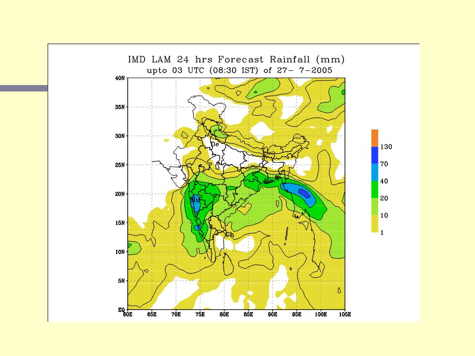
Numerical Models in IMD MODELSourceResolutionINPUT Limited Area Analysis Since 1995 NCEP Regional OI scheme 1985 1 0 x1 0 lat./long GTS + NCMRWF T-80 Forecast Limited Area Model Since 1995 FSU grid point model - 1992 0.75 0 x0.75 0 lat./long Limited Area Analysis + NCMRWF T-80 Forecast for Boundary Regional Spectral Model Since April 2003 FSURSM – 1998 0.68 0 x0.75 0 lat./long NCMRWF T-80 Analysis & Forecast Fields Quasi Lagrangian Model Since 2000 NCEP- 1992 40 km 40 km Limited Area Limited Area Analysis + NCMRWF T-80 Forecast Analysis + NCMRWF T-80 Forecast

12
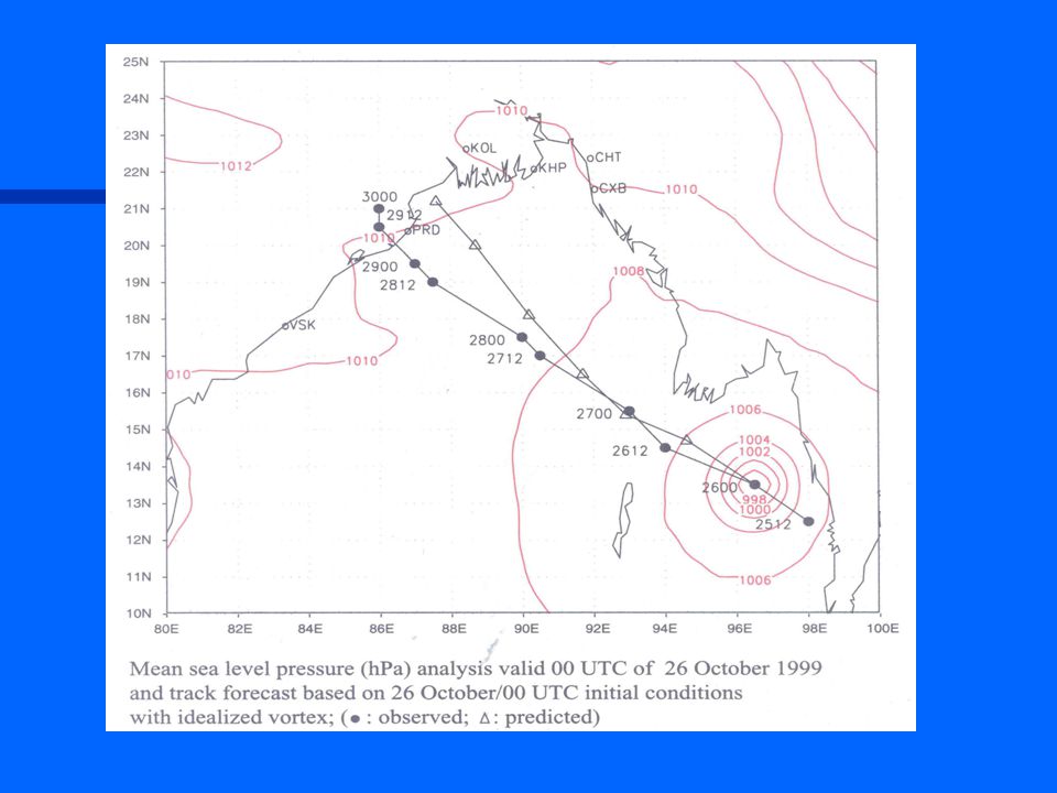
Tropical Cyclone Forecasting & Warnings n IMD’s Radar network and satellite monitoring are such that no Cyclone can go undetected n Cyclone Warnings are issued in Four Stages right from its early formation till its dissipation n IMD’s cyclone warning system is equivalent to that of any TC warning Centre in the world. n TC warnings are issued to Central/State/District level authorities, Public (through Media), Ports/shipping, Fisheries, Road/Railway transports, Aviation, Industries, etc. n Recent advancements have brought down the 24 forecast errors to less than 150 km. Concerted efforts are on to reduce the errors further.
, Ports/shipping, Fisheries, Road/Railway transports, Aviation, Industries, etc. n Recent advancements have brought down the 24 forecast errors to less than 150 km. Concerted efforts are on to reduce the errors further..")
13
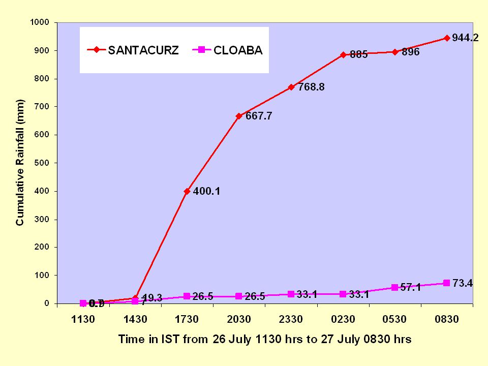
Record Rainstorm in Bombay Santacruz (94) Colaba (7) Dharavi (49) Bhandup (81) Vihar Lake (104) Thane (74)Tulsi Lake (60) 26 July, 2005
 Colaba (7) Dharavi (49) Bhandup (81) Vihar Lake (104) Thane (74)Tulsi Lake (60) 26 July, 2005")
15
26 July, 2005 (09 UTC)
")
18
10 N 12 N 14 N 16 N 18 N R

20
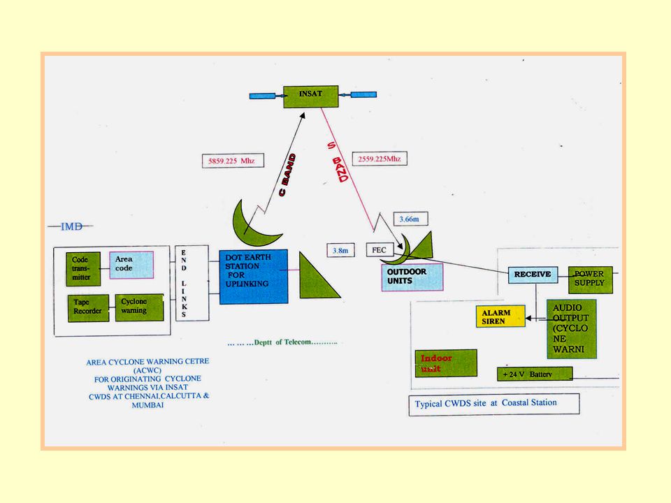
Dissemination of Warnings n Radio, Television, Print Media, Telephone, Fax, Telex, Telegrams, Police Wireless. n IMD Website : http://www.imd.ernet.in n IMDRAS workstations using “World Space” technology are being introduced n Cyclone Warning Dissemination System (CWDS) 250 Analog 250 Analog 100 Digital 100 Digital
 250 Analog 250 Analog 100 Digital 100 Digital.")
22
FUTURE PLANS MAJOR NEW INITIATIVES

23
Observational Network IMD has drawn plans to upgrade and strengthen its observation network in the coming years. Nation wide network of Automatic weather Stations (AWS) with spatial resolution of 50km Nation wide Doppler Weather Radar network
 with spatial resolution of 50km Nation wide Doppler Weather Radar network.")
24
New Observations The salient features are To install 4000 Satellite based Automatic Rain gauge station To install1000 Satellite based Automatic Weather Surface Stations To replace existing S-band Cyclone Detection Radars by Doppler Weather Radar 50 Storm detection radars (X-band) 52 upper-air (RS/RW) stations 45 Wind Profilers Strengthening of environmental monitoring stations Augmentation of earthquake monitoring Units Strengthening of radiation monitoring network
 52 upper-air (RS/RW) stations 45 Wind Profilers Strengthening of environmental monitoring stations Augmentation of earthquake monitoring Units Strengthening of radiation monitoring network")
25
NETWORK OF DOPPLER WX RADARS PROPOSED DOPPLER WEATHER RADARS

26
UPPER AIR STATIONS 37 Nos. UPPER AIR STATIONS To equip 5 stations with imported GPS Sonde and continue development of indegenous Sonde RSRW MULTIMET SAMEER IMS SRINAGAR PATIALA NEW DELHI LUCKNOW GORAKHPUR PATNA SILIGURI GUWAHATI MOHANBARI AGARTALA GWALIOR JODHPUR AHMEDABAD KOLKATA BHOPAL RANCHI MUMBAI AURANGABAD NAGPUR JAGDALPUR BHUVANESHWAR VISHAKHAPATNAM MACHLIPATNAM HYDERABAD GOA CHENNAI MANGALORE BANGALORE KARAIKA L COCHIN THIRUVANANTHAPURAM MINIICOY AMINI RAIPUR PORT BLAIR

27
PILOT BALLOON STATIONS 62 Nos. PILOT BALLOON STATIONS Supplement with 5 Wind Profilers and assess the impact of their induction

28
Weather Forecasting Implementation of High resolution forecast models Extended Range Forecast System (ERFS) for Climate Risk Management in Agriculture 500 District-wise Information Centres
 for Climate Risk Management in Agriculture 500 District-wise Information Centres")
29
NUMERICAL MODELS (2005-2010) Data Assimilation System : 3D VAR ( Global & Regional AWS and Satellite data) Global Model : To run upto 72 hours for regional model boundary conditions (Daily two runs) Res. T256 Meso-scale model (00, 06, 12 & 18 UTC initial conditions) for RSMC domain 30S – 50N / 25E – 130E) Res. 0.5 0 Local Weather Forecast at Res. 0.25 0 Cyclone Model for Track Prediction at 10 kms Storm Surge Model.
 for RSMC domain 30S – 50N / 25E – 130E) Res Local Weather Forecast at Res Cyclone Model for Track Prediction at 10 kms Storm Surge Model..")
30
EARLY WARNING DISSEMINATION SYSTEM An Integrated System for all weather hazards and Tsunamis. Issues to address – User Requirements, Timelines, Contents (Text and Visuals), Language, Uncertainties. Dissemination - Through Digital CWDS Systems with Centralized Uplink at Delhi + One Standby uplink at Chennai. 8 Control Rooms at Warning Centres with Workstations to generate Warning Text, Remotely activate Uplink through VSAT’s. 1000 receivers in disaster prone areas with Siren, Voice announcement, PC/FAX connectivity for text messages, acknowledge transmitter, in-built key pad for short message transmission. 128Kbps data transfer rate. solar powered battery back-up.
, Language, Uncertainties. Dissemination - Through Digital CWDS Systems with Centralized Uplink at Delhi + One Standby uplink at Chennai. 8 Control Rooms at Warning Centres with Workstations to generate Warning Text, Remotely activate Uplink through VSAT’s. 1000 receivers in disaster prone areas with Siren, Voice announcement, PC/FAX connectivity for text messages, acknowledge transmitter, in-built key pad for short message transmission. 128Kbps data transfer rate. solar powered battery back-up..")
31
Collaborative Programmes National Organisations: NCMRWF, IITM, IIT Delhi, IISc, IAF, Indian Navy, DAC, SASE (DRDO) etc. International Organisations: WMO/ESCAP, SAARC World Bank Assistance Programme UKMO, FSU, IRI, NCEP USAID Programme IMD-SMRC on Development of Cyclone Track Prediction Model

32
CONCLUSIONS IMD has the capacity to monitor and forecast Large scale features very well through the existing infrastructure To improve nowcasting/very short range forecasting of meso scale events India needs the following :- Automatic Rain gauges – 4000 Nos. Automatic Weather Stations -1000 Nos, - part time stations to be converted on higher priority - part time stations to be converted on higher priority Doppler weather radars: 57 to be provided (existing 4) 4 more being planed for procurement (2 indigenous + 2 imported) Wind Profiler – 5 Nos - in pilot phase To equip at least 5 upper air stations with imported state-of-the-art sonde till improvement of indegeneous sonde. -Immediate action to be started by IMD Acquisition and deployment of high power computing platform for running operational Global, Regional & Mesoscale models. A proposal for seeking the Govt.’s approval is being pursued vigorously.
 4 more being planed for procurement (2 indigenous + 2 imported) Wind Profiler – 5 Nos - in pilot phase To equip at least 5 upper air stations with imported state-of-the-art sonde till improvement of indegeneous sonde. -Immediate action to be started by IMD Acquisition and deployment of high power computing platform for running operational Global, Regional & Mesoscale models. A proposal for seeking the Govt.’s approval is being pursued vigorously..")
34
26 July, 2005 (12 UTC)
")
Similar presentations

 C Asia Air Survey co., ltd New Forecast Technologies for Disaster Prevention and Mitigation 1.>")


: The Content Standard of Alerts and Notifications in Disasters and Emergencies presented by Eliot Christian, Consultant.>")


 Peter Chen Chief, Data-Processing and Forecasting System Division Weather and Disaster Risk Reduction.>")


>")
