Download presentation
Presentation is loading. Please wait.

8
Site Location Site Bus Stop Footbridge 400, 800, 1,200 and 1,600 Metre Walk Distance Primary Shopping Areas 3 4 2 4 2 2 1 1 5 2 2 3 4 1 5 Infant School (Havant Fairfield and Glenhurst) Primary School (Bosmere, Emsworth and Sharps Copse) Secondary School (Warblington School) Convenience Store (Nisa Extra and One-Stop) Supermarket (Waitrose)
 Primary School (Bosmere, Emsworth and Sharps Copse) Secondary School (Warblington School) Convenience Store (Nisa Extra and One-Stop) Supermarket (Waitrose)")
9
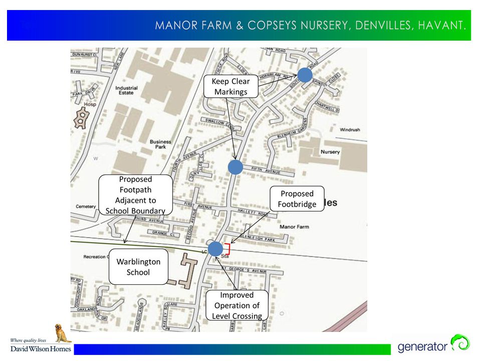
Existing Problems In the past there were issues with lorries accessing the Copseys Nursery site through surrounding residential streets unsuited for this purpose. This activity could return to the site. The main issue in the area is the operation of the level crossing and the impact this has on traffic flows and pedestrian safety, with queues of up to 60 vehicles recorded at the busiest time. Some queuing also occurs at the Southleigh Road/Emsworth Road signal junction. Our understanding is that there is scope to amend the timing of the traffic signal to reduce this. A review of the level crossing video camera indicates that on average once the level crossing barriers are raised, 22 vehicles per minute clear the crossing in each direction. Therefore, even during the busiest periods of level crossing activity, traffic will clear the level crossing within 3 minutes, when it opens.

10
Level Crossing There are a number of problems created by the level crossing including traffic queues and delays and a significant health and safety issue, as pedestrians and school children impede closing barriers and mix with traffic. Southern Railway have confirmed that the level crossing is monitored by CCTV. If the operators see large numbers of pedestrians at the crossing and perceive a safety risk, they will keep the barriers down during short periods between trains. This control is the cause of some of the long closures observed on site. Surveys undertaken showed that a maximum southbound queue of 29 vehicles and a maximum northbound queue of 15 vehicles was recorded during the morning peak hour (8am-9am). In the evening peak hour (5pm-6pm) queues of up to 60 vehicles northbound and 25 vehicles southbound were recorded. When there are problems with train services the crossing can be shut for extended periods. This queue of 60 vehicles is as a result of the crossing being down for 7 minutes 40 seconds. The development will generate less than 1 vehicle per minute onto Southleigh Road in each direction at peak times. On this basis the maximum number of vehicles that will be added to the back of each level crossing queue will be less than 5 vehicles.
. In the evening peak hour (5pm-6pm) queues of up to 60 vehicles northbound and 25 vehicles southbound were recorded. When there are problems with train services the crossing can be shut for extended periods. This queue of 60 vehicles is as a result of the crossing being down for 7 minutes 40 seconds. The development will generate less than 1 vehicle per minute onto Southleigh Road in each direction at peak times. On this basis the maximum number of vehicles that will be added to the back of each level crossing queue will be less than 5 vehicles..")
11
Origin/Destina tion Northbound to Town Northbound to A27 Southbound to Town Southbound to A27 Journey Time Surveys Journey time surveys between the site, the town centre and the A27 junction demonstrated that when the level crossing is closed there is little difference in journey time between driving north via a longer route, or driving south, once the delays at the crossing are taken into account. Those vehicles travelling northbound would benefit from free-flowing conditions, and whilst this may not mean that they always reach their destination any quicker, it is a significant factor in a motorist’s decision as to which route to take. Roads to the north of the site have sufficient capacity and the traffic impact on this part of the network and through Emsworth is predicted to be relatively minor.

12
Existing Traffic Surveys The surveys undertaken in May 2011 at Fifth Avenue/Southleigh Rd are consistent with the traffic flows recorded in May 2012 via a CCTV survey. The 2011 surveys recorded - in the AM Peak = 31 departures and 10 arrivals. In the PM Peak = 14 departures and 9 arrivals. The 2012 surveys recorded -in the AM Peak = 30 departures and 13 arrivals. In the PM Peak = 4 departures and 21 arrivals.

13
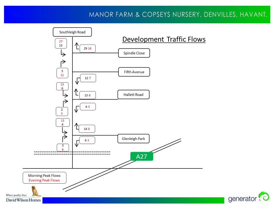
Predicted Traffic Generation Car ownership for the St. Faith’s ward is 1.3 vehicles per dwelling based on 2001 census data. It is accepted that the level of car ownership for the residents of Hallett Road, Glenleigh Park, Fifth Avenue and Spindle Close may be slightly higher (1.67 from the work undertaken by the W&DRA). A parking ratio of 2 spaces per dwelling will be provided on site for the proposed Copsey’s Nursery/Manor Farm development. Based on surveys of similar housing sites, the proposed scheme is predicted to generate around 115 vehicle movements in each of the morning and evening peak hours based upon 191 residential dwellings. Surveys of the existing traffic flow from roads leading onto Southleigh Road have shown that the average vehicle movements currently generated per house are lower than those used in our calculations. Studies of existing traffic flows and journey times suggest that the majority of traffic associated with the site, up to 70%, would travel north to avoid the level crossing, and therefore not contribute to the existing queuing problem.
. A parking ratio of 2 spaces per dwelling will be provided on site for the proposed Copsey’s Nursery/Manor Farm development. Based on surveys of similar housing sites, the proposed scheme is predicted to generate around 115 vehicle movements in each of the morning and evening peak hours based upon 191 residential dwellings. Surveys of the existing traffic flow from roads leading onto Southleigh Road have shown that the average vehicle movements currently generated per house are lower than those used in our calculations. Studies of existing traffic flows and journey times suggest that the majority of traffic associated with the site, up to 70%, would travel north to avoid the level crossing, and therefore not contribute to the existing queuing problem..")
15
Transport Benefits of the New Scheme -1- Various measures are being promoted to improve the local transport network. The most significant of these proposals is a footbridge to connect the platforms at Warblington Station. Discussions with Network Rail are ongoing. The footbridge will: 1.Minimise the risk of pedestrian injury from traffic and increase pedestrian accessibility to amenities south of the railway line. 2.Allow traffic to flow more freely over the crossing, particularly at peak pedestrian periods such as school start and finish times, when pedestrians mixing with traffic impedes vehicular flow. 3.Reduce the length of time it takes to close the level crossing gates, as pedestrians often walk under them as they close, resulting in longer delays for traffic. The footbridge will potentially allow the crossing to be raised for the short periods between trains, reducing closure times to less than the maximum 7 minutes 40 seconds. 4.Reduce the time to walk to the town centre to around 12 minutes, and encourage both existing and future residents to reduce their car usage for trips to the town centre. The provision of the footbridge, coupled with the Council’s discussions with Network Rail seeking amendments to train timetables, will mean that the level crossing is closed for less time, which will improve traffic flow and reduce queuing.

16
Transport Benefits of the New Scheme -2- 1.Additional road markings at the junctions onto Southleigh Road may also be added to assist drivers in accessing the road at peak times. This will include keep clear markings to avoid vehicles blocking the junction. The development of the site for housing will prevent the return of lorries, and other associated traffic servicing Copseys Nursery, to the local road network. 2.The recently consented footpath to the town centre will further improve accessibility to central Havant, and there is the potential for the proposed development to contribute towards the funding of this new link. 3.The proposed footbridge will be located adjacent to the level crossing. A bicycle gully will be provided adjacent to the stepped access which will enable both pedestrians and cyclists to travel without experiencing the delay associated with the operation of the level crossing. 4.A 5% increase in walking and cycling as opposed to journeys by car would result in 34 vehicles per hour (based on 1,350 vehicles/hour) fewer in each direction on Southleigh Road and mitigate the impact of the proposed development, ensuring that traffic congestion along Southleigh Road does not worsen following the completion of the proposed development.
 fewer in each direction on Southleigh Road and mitigate the impact of the proposed development, ensuring that traffic congestion along Southleigh Road does not worsen following the completion of the proposed development..")
18
Pedestrian Footbridge Plan

19
Warblington Footbridge Draft Programme March – May: Initial meetings held with Network Rail and Hampshire County Council to agree the parameters of footbridge an approval process. May: Legal documentation signed with Network Rail to facilitate exploratory surveys to inform the bridge design. June: Surveys of the proposed site for the Bridge to be undertaken. June – July: Agree design parameters and finalise design. August – September: Network Rail and Hampshire County Council Approval in Principle process.

20
Pedestrian Footbridge – Artist’s Impression

21
Summary The main existing transport problem in the area is the level crossing and the congestion and the safety issues this creates. The proposed housing scheme will generate additional traffic, which during peak hours amounts to an additional 115 vehicles. This will be divided over the four proposed access routes into the site. The highest impact at the level crossing at peak times, will be 7% increase in existing traffic flow on Southleigh Road, which would mean an increase in the existing longest queue of 5 vehicles. Traffic flows from the site will be considerably less at other times of the day. This impact will be mitigated by the proposed footbridge as it would both improve safety and remove pedestrians from mixing with traffic and affecting the operation of the barrier. The footbridge would also allow people to pass over the railway line and would encourage more to walk to the Town Centre, particularly when combined with the recently consented new footpath.

Similar presentations


. Clifton Gate, York (3,400 dwellings).>")
 to connect to Lodge Jct crossing Carriageway widened into wooded area Proposed area for landscaping.>")
