Download presentation
Presentation is loading. Please wait.

1
Cape Cod Transit is Smart Transit and About to Get Smarter Lawrence J. Harman and Uma Shama, PhD Co-Directors, GeoGraphics Laboratory Bridgewater State University June 2013

2
Very High Incidence of Elderly Residents

3
Low density resident population

4
Trip origins and destinations for human services have distinct spatial and temporal characteristics

5
Historical FTA Support to CCRTA 1 st FTA Rural Transit Intelligent Transportation System Demonstration in U.S. – Real-time Web-Mapping of transit vehicles (c. 1997) Geographic Information Systems Decision Support (c. 1998) Cape Cod tourist electronic transit pass (c. 2001) FTA ITS Foundation Research: “e-Transit village” demonstrating Outdoor WiFi Mesh Network for transit communications (c. 2006)
 Geographic Information Systems Decision Support (c. 1998) Cape Cod tourist electronic transit pass (c. 2001) FTA ITS Foundation Research: e-Transit village demonstrating Outdoor WiFi Mesh Network for transit communications (c. 2006).")
6
FTA – Bridgewater State U Outdoor WiFi prototype for Real-Time Transit Information and Security c. 2006

7
2006 e-Transit Village WiFi Mesh Network

8
Recent CCRTA ITS (2009- 2013) FTA-CCRTA Economic Stimulus ITS project – Mobility Management Call Center – Multi-Modal Inter-Regional Google Transit – Multimodal Inter-Regional Real-Time AVL – Smart phone app for p/w/d for all platforms – Inter-Regional inter-operable smart card for MA Related SE MA Open Cape Broadband Project – 100 Gbps middle mile fiber-optic cable to Internet – 700 MHz Wireless Public Safety Regional Radio
 FTA-CCRTA Economic Stimulus ITS project – Mobility Management Call Center – Multi-Modal Inter-Regional Google Transit – Multimodal Inter-Regional Real-Time AVL – Smart phone app for p/w/d for all platforms – Inter-Regional inter-operable smart card for MA Related SE MA Open Cape Broadband Project – 100 Gbps middle mile fiber-optic cable to Internet – 700 MHz Wireless Public Safety Regional Radio")
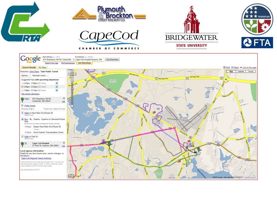
10
Inter-Regional Web-based Automatic Vehicle Location (AVL) Mapping Multimodal Web Mapping of vehicle location – Local and regional fixed route service – Dial-A-Ride Transportation (DART) – Inter-city bus from Boston – Inter-city bus from NYC – Public and private ferries on Nantucket Sound – Private ferries on Cape Cod Bay
 Mapping Multimodal Web Mapping of vehicle location – Local and regional fixed route service – Dial-A-Ride Transportation (DART) – Inter-city bus from Boston – Inter-city bus from NYC – Public and private ferries on Nantucket Sound – Private ferries on Cape Cod Bay")
11
Intermodal Web AVL – Prototype

12
Integration of AVL, MDTs and Electronic Farebox Data Vehicle location technology and Mobile Data Terminals (MDT) were upgraded on all CCRTA’s fixed route, route deviation and dial-a-ride transportation (DART) Automatic Fare boxes and Smart Card technology integrated with GPS-based AVL and computer assisted scheduling and dispatching in real-time through state- of-the-art mobile data terminals.
 were upgraded on all CCRTA’s fixed route, route deviation and dial-a-ride transportation (DART) Automatic Fare boxes and Smart Card technology integrated with GPS-based AVL and computer assisted scheduling and dispatching in real-time through state- of-the-art mobile data terminals.")
13
Innovative Real-Time Customer Information Systems Prototypes Large Screen Displays in Terminals and Major Destinations for integrated transit and inter-city connectors. – Hyannis Transportation Center, Cape Cod Mall, CC Community College, Barnstable Airport. LED displays of bus location at Cape Cod style bus shelters – 10 LED displays with ETA installed this spring. Smart phone applications for Cape Cod residents, tourists and persons with disabilities.

14
New Cape Cod Connector Services New Local ServicesNew Modes

15
Transportation Center Info Booth

16
Travelers using real-time Inter-City tracking displays at Hyannis terminal

17
Enhanced Bus Shelter at Seacoast Shores, East Falmouth

18
CCRTA Smartphone Application for Tourists and persons with disabilities - work in progress CCRTA and Bridgewater State University are developing a smartphone application that will combine all the features of the large screen customer information displays and enhanced bus shelter ETA displays into one application that can be downloaded onto a smart phone from the CCRTA website. In addition to real-time tracking of vehicles on a map, features include NextBus® Estimated Time of Arrival for each stop and for each route. For passengers with cognitive disabilities or memory loss, they can be connected in real-time with caregivers and family including geographic location and video using an emergency button. The application will be available on Android, iPhone, and Window Mobile phones.

19
Reverse-Geocoding of Intermodal Automatic Vehicle Location – Personal Data Assistants (PDAs) for persons with disabilities and tourists on smart phones and laptops
 for persons with disabilities and tourists on smart phones and laptops")
20
Cape Cod “Charlie Cards” Electronic Fare Systems (EFS) for Cape Cod transit users that are – Interoperable with the MBTA’s “Charlie Card” and 12 other Massachusetts transit agencies. – Integrated with real-time spatial data collection on every vehicle for service planning and evaluation. Provides bi-directional data flow between EFS and operations databases -- uploads and downloads. Collateral data streams provide redundancy

21
Cape Cod’s inter-regional “smart card” CCRTA’s Charlie Card Interoperable with MBTA and 12 Massachusetts RTA’s +

22
MBTA mTicketing on Smartphones The Massachusetts Bay Transportation Authority has introduced smart phone ticketing on it’s commuter rail and ferry services using the Mesabi payment system. This system is being extended to the seasonal CapeFLYER passenger rail service from Boston to Cape Cod and, in the future, to inter-city bus connections to Cape Cod.

23
Convergence of Economic Stimulus Infrastructure Projects on Cape Cod

24
Smarter Regional Transit Rqmts Need to provide “last mile” wireless broadband to complete OpenCape Broadband’s “middle mile” connectivity, especially in “forever rural” Outer Cape and Cape Cod National Seashore. Need to provide high capacity “Wi-Gig” for wireless local area network on transit vehicles, in transit shelters and at major destinations for real-time en- route trip planning, particularly for persons with disabilities using smart phones for navigation. Provides alternative to GPS for real-time local positioning systems (LPS) along transit routes.
 along transit routes..")
25
Smart is as Smart Does 1 Institutionally – build “outdoor WiFi” using 21 st Century emerging technologies, e.g.: – WLAN – WiFi/WiGig: IEEE 802.11ac, ad, and p – Connected vehicles (USDOT) Vehicle to vehicle (V2V) for safety Vehicle to infrastructure (V2I e.g. e-Transit/security) Vehicle to Transportation Center (Remote Drivers/robo- Dial-A-Ride Transportation [DART] ) Vehicle-to-consumer with streaming video inside and outside vehicle and shelters at 1 Gbps. (V2V, V2I)
 Vehicle to Transportation Center (Remote Drivers/robo- Dial-A-Ride Transportation [DART] ) Vehicle-to-consumer with streaming video inside and outside vehicle and shelters at 1 Gbps. (V2V, V2I).")
26
Smart is as Smart Does 2 Individually – create mobile devices as tools for access and mobility – Smart phone/tablet of the next decade for CIS – Adaptive computing approaches to individual access and mobility from mass market technology Open systems for operating handheld computing (e.g. Android “phablet”) Open data exchange for the smart traveler Travel training for individuals with disabilities to use technology as enablers not barriers
 Open data exchange for the smart traveler Travel training for individuals with disabilities to use technology as enablers not barriers.")
27
2020 Vision for Transit Technology It’s all about the customer – Easy to use intermodal travel planning on the Internet – Easy to find up-to-the minute status, location, and ETA for all modes to, from and on Cape Cod using the Web – Easy to use reservation, cancellation and trip change applications using the Internet and telephone. – Easy to pay intermodal smart cards to travel to, from and throughout the Cape and Islands. – Transparency and accountability of public and private transportation providers through technology (OpenGov). – Carless and carefree on Cape Cod – Semi-autonomous vehicles for p/w/d and seniors
. – Carless and carefree on Cape Cod – Semi-autonomous vehicles for p/w/d and seniors.")
28
Presenter Contact Information Larry Harman – GeoGraphics Laboratory, Conant Science and Mathematics Center, Bridgewater State University, Bridgewater, MA 02325 – larry@geographicslab.org larry@geographicslab.org – www.geolabvirtualmaps.com www.geolabvirtualmaps.com – www.geographicslab.org www.geographicslab.org

Similar presentations
 to Cape Cod L. Harman, U. Shama, C. Van Zandt Bridgewater State University,>")
>")

![Travel Training Program. Planning Your Trip [Insert Image]](/5/1509402/big_thumb.jpg "Travel Training Program. Planning Your Trip [Insert Image]>")


 Technology 19th Annual Transportation Disadvantaged Best Practices and Training.>")


 ? The application of advanced sensor, computer, electronics,>")

 Transit ITS CEE582.>")


