Download presentation
Presentation is loading. Please wait.

1
In 1785 residents of the Kentucky District petitioned Virginia to recognize the district as a “free & independent state, to be known by the name of the Commonwealth of Kentucky,” meaning “a sound and prosperous state.” On June 4, 1792, after Kentucky attained statehood, the General Assembly declared the word “Commonwealth” as part of Kentucky’s official name. (ref: Article by Ron Bryant, “Kentucky Encyclopedia,” page 220)
.")
2
LAND CLAIMS PRIOR TO THE ESTABLISHMENT OF THE VIRGINIA LAND OFFICE As “various & vague claims to unpatented land under the former and present government may produce tedious and infinite litigation and disputes, and in the mean time purchasers would be discouraged from taking up lands upon terms lately prescribed by law, whereby the fund to be raised in aid of the taxes for discharging the public debt, would be in great measure frustrated”, the Virginia General Assembly approved legislation in May 1779 that addressed early land claims prior to the establishment of the land patenting process. In response to settlers’ petitions for a method to resolve land disputes and appropriate land in Kentucky, the Virginia General Assembly passed legislation in 1779 known as the “Virginia Land Laws.” To research the complete text of Land Law A & B, access “Legislation” on the Secretary of State’s Land Office Reference Library channel at http://www.sos.ky.gov/land/reference/legislation/vakypatents/.

3
Key provisions of Land Law (A) include: Bona fide settlers ‘upon the western waters’ prior to January 1, 1778, were entitled to 400 acres of land including their settlement. Proof of planting a crop of corn or a residency of at least one year was required. (Sections IV & V) Settlers could purchase a preemption warrant to patent an additional 1000 acres adjoining their settlement claim. (Section V) Persons who settled ‘upon the western waters’ after January 1, 1778, were entitled to a 400 acre Preemption Warrant claim which included their settlement. (Section V) Persons who had “marked out” claims and built any house or hut or made any other improvements prior to January 1, 1778, were entitled to one 1000 acre preemption warrant if the Land Commission approved their claim. (Section V) Note: This covered “chop claims” as well as lottery cabins. All locations (Entries) made by officers & soldiers upon lands of actual settlers were declared void. (Section V) A four-man Land Commission decided settlers’ claims at court meetings at St. Asaph or Ft. Logan (near Stanford), Boonesborough, Harrodsburg, Bryant’s Station (Lexington), and the Falls of the Ohio (Louisville). The Clerk of the Land Commission recorded the names of settlers who qualified for 400 acre certificates of settlement and the various types of preemption warrants in a journal. Over the years, this journal has been nicknamed “Kentucky’s Doomsday Book.” Similar in function to England’s “Domesday Book” commissioned by William the Conqueror in 1086, the Kentucky journal lists the names of settlers and the amount of acreage they were allotted.
 Settlers could purchase a preemption warrant to patent an additional 1000 acres adjoining their settlement claim. (Section V) Persons who settled ‘upon the western waters’ after January 1, 1778, were entitled to a 400 acre Preemption Warrant claim which included their settlement. (Section V) Persons who had marked out claims and built any house or hut or made any other improvements prior to January 1, 1778, were entitled to one 1000 acre preemption warrant if the Land Commission approved their claim. (Section V) Note: This covered chop claims as well as lottery cabins. All locations (Entries) made by officers & soldiers upon lands of actual settlers were declared void. (Section V) A four-man Land Commission decided settlers’ claims at court meetings at St. Asaph or Ft. Logan (near Stanford), Boonesborough, Harrodsburg, Bryant’s Station (Lexington), and the Falls of the Ohio (Louisville). The Clerk of the Land Commission recorded the names of settlers who qualified for 400 acre certificates of settlement and the various types of preemption warrants in a journal. Over the years, this journal has been nicknamed Kentucky’s Doomsday Book. Similar in function to England’s Domesday Book commissioned by William the Conqueror in 1086, the Kentucky journal lists the names of settlers and the amount of acreage they were allotted..")
4
On March 29, 2010, Kentucky Secretary of State Trey Grayson announced Kentucky’s Doomsday Book is now available for internet access on the “Secretary of State’s Land Office, Certificates of Settlement & Preemption Warrants” channel at http://www.sos.ky.gov/land/nonmilitary/settlements/. Researchers may view entries in the Doomsday Book, certificates issued by the Land Commission, and land patent files authorized by “Corn & Cabin” and preemption claims.http://www.sos.ky.gov/land/nonmilitary/settlements/

5
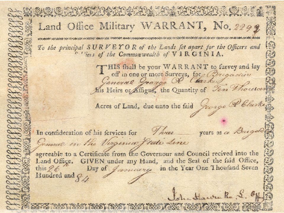
Sailor who served his 3 yr enlistment or to the end of the war -- 100 acres Soldier who served his 3 yr enlistment or to the end of the war -- 100 acres Noncommissioned officer who enlisted & served his 3 yr enlistment -- 200 acres Sailor who served throughout the war -- 400 acres Soldier who served throughout the war -- 400 acres Noncommissioned officer who served throughout the war -- 400 acres Subaltern-Cornet -- 2000 to 2666 acres Subaltern-Ensign -- 2000 to 2666 acres Subaltern-Lieutenant -- 2000 to 2666 acres Surgeon’s Mate -- 2666 to 8000 acres Surgeon -- 2666 to 8000 acres Chaplain -- 2666 to 8000 acres Captain -- 3000 to 4666 acres Major -- 4000 to 5333 acres Lt. Colonel -- 4500 to 6666 acres Colonel -- 5000 to 8888 acres Brigadier General -- 10,000 acres + Major General -- 15,000 to 17,500 acres And where any officer, soldier, or sailor shall have fallen or died in the service, his heirs or legal representatives shall be entitled to, and receive the same quantity of land as would have been due to such officer, soldier or sailor respectively, had he been living. Legislation by the Virginia General Assembly also compensated soldiers of the Virginia Continental Line and the Virginia State Line for their service in the Revolutionary War. Veterans, heirs, or assignees were issued bounty land warrants that were used to patent land in Virginia’s Military District in Kentucky or Ohio. Allotments for service and rank were as follows: To research Virginia Revolutionary War veterans and view entries from Military Warrants Registers, access the “Revolutionary War Warrants Database” on the Kentucky Secretary of State’s Land Office Website at http://apps.sos.ky.gov/land/military/revwar/. Many entries link to colorscanned images of land patent files.http://apps.sos.ky.gov/land/military/revwar/

6
Virginia Series: 9441 Patents (1779-1792) Old Kentucky Series: 7668 Patents (1792+) Documents housed with the Kentucky Secretary of State’s Office, Frankfort, Ky. KENTUCKY LAND PATENTS: Virginia & Old Kentucky Series Patents in this area were authorized by: French & Indian War Warrants; Governors’ Warrants; Certificates of Settlement; Preemption Warrants (400a & 1000a); Treasury Warrants; Importation Warrants; Acts for Poor Persons; Special Acts of the Virginia or Kentucky General Assembly; Acts for Academies & Seminaries (1798+ in former Military District); & “Infrastructure” Warrants, ex. Finding Salt or Establishing Roads. Location of Military District: “Southeast course from the head of Green River to the Cumberland mountains; with the said mountains to the Carolina line; with the line to the Cherokee or Tennessee River; with the said River to the said Green river; until the farther order.” Ref: Virginia Land Law of 1779. Notes: (1) Some Military Patents extend to the 36° 30’ parallel into Tennessee due to the former Kentucky boundary. (2) Although the eastern boundary of the Military District set the line as the Cumberland Mountains, the Land Law further stated no land could be entered or located within the county & limits of the Cherokee Indians. Portions of the shaded counties were ceded in 1805 under the Tellico Treaty. (3) Soldiers who had settled in the southern area of the Jackson Purchase had to wait until 1818 to patent their land. Their patents comprise the West of Tennessee River Military Series. Several patents in the northern area of the Jackson Purchase were authorized by Treasury Warrants prior to 1818. Military District Reserved for Virginia Revolutionary War Veterans Chickasaw Land (1818) Cherokee Land (1805)
; Treasury Warrants; Importation Warrants; Acts for Poor Persons; Special Acts of the Virginia or Kentucky General Assembly; Acts for Academies & Seminaries (1798+ in former Military District); & Infrastructure Warrants, ex. Finding Salt or Establishing Roads. Location of Military District: Southeast course from the head of Green River to the Cumberland mountains; with the said mountains to the Carolina line; with the line to the Cherokee or Tennessee River; with the said River to the said Green river; until the farther order. Ref: Virginia Land Law of Notes: (1) Some Military Patents extend to the 36° 30’ parallel into Tennessee due to the former Kentucky boundary. (2) Although the eastern boundary of the Military District set the line as the Cumberland Mountains, the Land Law further stated no land could be entered or located within the county & limits of the Cherokee Indians. Portions of the shaded counties were ceded in 1805 under the Tellico Treaty. (3) Soldiers who had settled in the southern area of the Jackson Purchase had to wait until 1818 to patent their land. Their patents comprise the West of Tennessee River Military Series. Several patents in the northern area of the Jackson Purchase were authorized by Treasury Warrants prior to Military District Reserved for Virginia Revolutionary War Veterans Chickasaw Land (1818) Cherokee Land (1805).")
8
In 1780 the Virginia General Assembly divided Kentucky County into three separate counties: Fayette (county seat: Lexington); Lincoln (county seat: Harrodsburg); and Jefferson (county seat Louisville). All three counties converge at the point where Benson Creek flows into the Kentucky River in Frankfort. Franklin County was formed in 1795 out of Mercer County (daughter of Lincoln County), Shelby County (daughter of Jefferson County), & Woodford County (daughter of Fayette County). Researchers are encouraged to consider county formation dates and names of mother counties when studying the history of Kentucky and her people. MONTGOMERY WASHINGTON Kentucky County, Virginia As Divided in 1780 FAYETTE Lexington Louisville JEFFERSON Harrodsburg LINCOLN
, Shelby County (daughter of Jefferson County), & Woodford County (daughter of Fayette County). Researchers are encouraged to consider county formation dates and names of mother counties when studying the history of Kentucky and her people. MONTGOMERY WASHINGTON Kentucky County, Virginia As Divided in 1780 FAYETTE Lexington Louisville JEFFERSON Harrodsburg LINCOLN.")
9
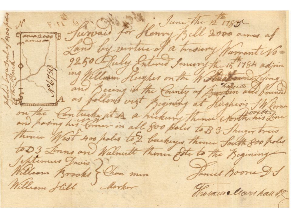
The Virginia Land Laws established a process for appropriating land in Kentucky. After statehood in 1792, Kentucky retained the same four-step process. Under the Compact with Virginia, patents issued prior to Kentucky’s statehood were declared valid. Land Patenting Process Step 1: Warrants (syn. CERTIFICATES, COMMISSIONERS’ CERTIFICATES, or SPECIAL ACTS OF THE GENERAL ASSEMBLY) Function: Authorize Entries in the Surveyors’ Book Samples: Military, Certificate of Settlement, Preemption Warrant, Treasury, Finding Salt, Clearing a Road, Poor Widows Warrant, Purchased from Kentucky Land Office, or Purchased from County Court. Legislation for Relief of Poor Persons, Certain Persons, or Establishing Academies/Seminaries. Key Points: Warrants may be assigned; warrants may be used in whole or in part; warrants do not convey title. Step 2: Entries in the County Surveyor’s Entry Book Function : Reserve land for field survey Key Points : Entries may be withdrawn or amended; research marginal notations; entries do not convey title. Step 3: Field Survey by the County Surveyor or his Deputy Function : Depict and describe the land being patented. Components : Most Field Surveys in the patenting process include: Plat Drawing, List of Warrant(s) being used, Name of Person(s) for whom the Survey is being made, County, Closest Watercourse, Metes & Bounds Description, Surveyor, Deputy Surveyor (if applicable), Chain Carriers or Chainmen (CC or CM), Housekeeper (HK)/Pilot/Director, Marker (MK) Magnetic Variation, and Date of Survey. Key Points : Field Surveys may be assigned; surveys do not convey title. Step 4: Issuance of the Grant by the Governor Function: Finalize the Land Patenting Process Components : Name of Governor or Lt. Governor, Name of Patent Recipient(s), Type of Warrant(s) Being Used, Warrant Number(s), County, Watercourse, Metes & Bounds Description, Date of Issuance, Year of the Commonwealth (Virginia or Kentucky), & the Signature of the Governor or Lt. Governor (on original document). NOTE: Original Grants, decorated with the Seal & Official Signature are sent to the Patent Recipient. The Land Office enters a copy of the Grant in the Land Office Grant Book. Key Points : Conveyances after the Grant is issued are filed with the county clerk as Deeds or in Wills; there is no central deed registration in Kentucky; there is no master patent map that depicts the location of Kentucky patents.
 Function: Authorize Entries in the Surveyors’ Book Samples: Military, Certificate of Settlement, Preemption Warrant, Treasury, Finding Salt, Clearing a Road, Poor Widows Warrant, Purchased from Kentucky Land Office, or Purchased from County Court. Legislation for Relief of Poor Persons, Certain Persons, or Establishing Academies/Seminaries. Key Points: Warrants may be assigned; warrants may be used in whole or in part; warrants do not convey title. Step 2: Entries in the County Surveyor’s Entry Book Function : Reserve land for field survey Key Points : Entries may be withdrawn or amended; research marginal notations; entries do not convey title. Step 3: Field Survey by the County Surveyor or his Deputy Function : Depict and describe the land being patented. Components : Most Field Surveys in the patenting process include: Plat Drawing, List of Warrant(s) being used, Name of Person(s) for whom the Survey is being made, County, Closest Watercourse, Metes & Bounds Description, Surveyor, Deputy Surveyor (if applicable), Chain Carriers or Chainmen (CC or CM), Housekeeper (HK)/Pilot/Director, Marker (MK) Magnetic Variation, and Date of Survey. Key Points : Field Surveys may be assigned; surveys do not convey title. Step 4: Issuance of the Grant by the Governor Function: Finalize the Land Patenting Process Components : Name of Governor or Lt. Governor, Name of Patent Recipient(s), Type of Warrant(s) Being Used, Warrant Number(s), County, Watercourse, Metes & Bounds Description, Date of Issuance, Year of the Commonwealth (Virginia or Kentucky), & the Signature of the Governor or Lt. Governor (on original document). NOTE: Original Grants, decorated with the Seal & Official Signature are sent to the Patent Recipient. The Land Office enters a copy of the Grant in the Land Office Grant Book. Key Points : Conveyances after the Grant is issued are filed with the county clerk as Deeds or in Wills; there is no central deed registration in Kentucky; there is no master patent map that depicts the location of Kentucky patents..")
10
1 pole or 1 rod=16.5 feet or 25 links 1 link=0.66 feet or 7.92 inches 1 chain=100 links, 4 rods, or 66 feet 80 chains=1 mile, 320 rods, 1760 yards, or 5280 feet 1 acre=10 sq. chains, 160 sq. rods, 4840 sq. yard, or 43,560 sq. feet 1 square mile=1 section of land or 640 acres Township=36 sq. miles (36 mile sq. sections) Surveying Measurements Surveys for land patents in eastern and central Kentucky were mapped by the metes and bounds method. Surveys for patents in the Jackson Purchase area in western Kentucky were mapped by the surveying method developed for public lands, i.e. Ranges, Townships & Sections. To search and locate non-military patents in the Jackson Purchase, access http://www.sos.ky.gov/land/nonmilitary/patentseries/tnrivernon/. The database links to colorscanned images of patent files and townships depicted on the 1885 Loughridge Map. http://www.sos.ky.gov/land/nonmilitary/patentseries/tnrivernon/ The surveyor used a compass for determining bearing and a transit for determining arc. Distance was measured in chains. A two-pole chain (33’) or a four-pole chain (66’ ) was carried by two chainmen. The same method of using chains for measurement, or chaining, may be seen during today’s football games. Members of the survey team known as “Markers” blazed trees or identified other points along survey lines.
 Surveying Measurements Surveys for land patents in eastern and central Kentucky were mapped by the metes and bounds method. Surveys for patents in the Jackson Purchase area in western Kentucky were mapped by the surveying method developed for public lands, i.e. Ranges, Townships & Sections. To search and locate non-military patents in the Jackson Purchase, access The database links to colorscanned images of patent files and townships depicted on the 1885 Loughridge Map. The surveyor used a compass for determining bearing and a transit for determining arc. Distance was measured in chains. A two-pole chain (33’) or a four-pole chain (66’ ) was carried by two chainmen. The same method of using chains for measurement, or chaining, may be seen during today’s football games. Members of the survey team known as Markers blazed trees or identified other points along survey lines..")
12
QUICK GUIDE: KEY POINTS TO REMEMBER The federal government does not issue land patents in Kentucky. Kentucky patents are authorized by Acts of the Virginia General Assembly (prior to 1792) or the Kentucky General Assembly. Warrants do not identify a certain tract or location. Neither warrants nor surveys convey title. Every step in the patent process must be followed. The Governor’s Grant finalizes the patenting transaction. Military grants comprise a small portion of Kentucky land patents. The only military warrants honored in Kentucky were for service in the French and Indian War and to Virginia veterans of the Revolutionary War. Most patents were authorized by purchasing treasury, state, or county warrants/certificates. County tax lists available at the History Center, KDLA, LDS Library, or many local libraries may help researchers determine the original patentee of properties reported for tax purposes. Kentucky did not honor warrants for service in the War of 1812, the Mexican War, or subsequent conflicts. Those warrants had to be used by the veteran, heir, or assignee in a federal public domain state, such as Missouri or Illinois. The Secretary of State's Office is the repository for over 100,000 patent files containing warrants, surveys, and grants. Researchers do not have to travel to Virginia to research Kentucky land patents prior to 1792. Those records were sent to Frankfort shortly after Kentucky became a state. Patents were issued to women as early as the 1700s. In some instances, they were heirs finishing patents initiated by their husband or a family member. In 1820, the Kentucky General Assembly allowed poor widows to patent no more than 100 acres of land under a widow’s warrant. African-Americans patented land in Kentucky prior to the Civil War. Land Office holdings are limited to land patents only. Although applications listing parents, family history, etc., were not required, there are instances in which wills, or other affidavits of descent, are part of the patent file. Wills are scanned for the Land Office website as they are located. Conveyances after patents are issued are filed with the county clerk as Deeds. There is no master patent map that depicts the location of patented properties.
 or the Kentucky General Assembly. Warrants do not identify a certain tract or location. Neither warrants nor surveys convey title. Every step in the patent process must be followed. The Governor’s Grant finalizes the patenting transaction. Military grants comprise a small portion of Kentucky land patents. The only military warrants honored in Kentucky were for service in the French and Indian War and to Virginia veterans of the Revolutionary War. Most patents were authorized by purchasing treasury, state, or county warrants/certificates. County tax lists available at the History Center, KDLA, LDS Library, or many local libraries may help researchers determine the original patentee of properties reported for tax purposes. Kentucky did not honor warrants for service in the War of 1812, the Mexican War, or subsequent conflicts. Those warrants had to be used by the veteran, heir, or assignee in a federal public domain state, such as Missouri or Illinois. The Secretary of State s Office is the repository for over 100,000 patent files containing warrants, surveys, and grants. Researchers do not have to travel to Virginia to research Kentucky land patents prior to Those records were sent to Frankfort shortly after Kentucky became a state. Patents were issued to women as early as the 1700s. In some instances, they were heirs finishing patents initiated by their husband or a family member. In 1820, the Kentucky General Assembly allowed poor widows to patent no more than 100 acres of land under a widow’s warrant. African-Americans patented land in Kentucky prior to the Civil War. Land Office holdings are limited to land patents only. Although applications listing parents, family history, etc., were not required, there are instances in which wills, or other affidavits of descent, are part of the patent file. Wills are scanned for the Land Office website as they are located. Conveyances after patents are issued are filed with the county clerk as Deeds. There is no master patent map that depicts the location of patented properties..")
13
Kentucky Secretary of State Trey Grayson Land Office Website: http://www.sos.ky.gov/land WHAT IS ONLINE? Virginia & Old Kentucky Patent Series: Patents authorized by Revolutionary War Warrants, Certificates of Settlement & Preemption Warrants, Treasury Warrants, and special Acts of the General Assembly. Includes colorscanned images Revolutionary War Warrants Database: Includes images from Warrants Register & links to patent files West of Tennessee River Military Patent Series : Patents in the Jackson Purchase authorized by Revolutionary War Warrants issued by Virginia. Database links to colorscanned images of patent files. West of Tennessee River Non-Military Series: Patents in the Jackson Purchase authorized by warrants purchased at public sale. Database links to colorscanned images of patent files. Jackson Purchase Locator County Court Order Series Database (over 8200 patents link to scanned images) Lincoln Entries Database with scanned images: Entries for old Lincoln County, Virginia, excluding the Military District. Kentucky Cities Website Biographies of Kentucky’s Secretaries of State: Includes Timeline & complete text of all four Kentucky Constitutions and names of delegates to constitutional conventions Reference Library includes articles of historical interest, maps, glossary, gazetteer, and selected legislative Acts WHAT IS NOT ONLINE AT THIS TIME? South of Green River Patent Series: Patents in the former Military District opened to settlers in 1795 Kentucky Land Warrants Patent Series: Patents authorized by warrants purchased from the Kentucky Land Office Tellico Patent Series: Patents in the area of southeastern Kentucky acquired from the Cherokee Indian Nation in 1805 South of Walker’s Line Patent Series : Patents in northern Tennessee Fayette County, Virginia, Entry Books Jefferson County, Virginia, Entry Books (Note: These books include Kentucky County, Virginia, Entries.) Entry Books for the Military District
 Lincoln Entries Database with scanned images: Entries for old Lincoln County, Virginia, excluding the Military District. Kentucky Cities Website Biographies of Kentucky’s Secretaries of State: Includes Timeline & complete text of all four Kentucky Constitutions and names of delegates to constitutional conventions Reference Library includes articles of historical interest, maps, glossary, gazetteer, and selected legislative Acts WHAT IS NOT ONLINE AT THIS TIME. South of Green River Patent Series: Patents in the former Military District opened to settlers in 1795 Kentucky Land Warrants Patent Series: Patents authorized by warrants purchased from the Kentucky Land Office Tellico Patent Series: Patents in the area of southeastern Kentucky acquired from the Cherokee Indian Nation in 1805 South of Walker’s Line Patent Series : Patents in northern Tennessee Fayette County, Virginia, Entry Books Jefferson County, Virginia, Entry Books (Note: These books include Kentucky County, Virginia, Entries.) Entry Books for the Military District.")
Similar presentations


>")
