Download presentation
Presentation is loading. Please wait.

1
June 2005 Upgrade Package for High Resolution Window (HRW) Decision Brief where the nation’s climate and weather services begin Mesoscale Modeling Branch Geoff DiMego, Eric Rogers and Matt Pyle 24 June 2005
 Decision Brief where the nation’s climate and weather services begin Mesoscale Modeling Branch Geoff DiMego, Eric Rogers and Matt Pyle 24 June 2005")
2
June 2005 Upgrade Package Background – Original Plan Original AOP Milestone was to add 4 more WRF runs to the HiResWindow slot: – Add to existing two control runs of WRF-ARW (10km/50 level) and WRF-NMM (8km/60 level) – Two pairs of runs added based on a breeding- cycle for each control run making total of 6 – There was no room to do this in Q4 2004 because of delays in CCS upgrade availability – Hurricane runs would supercede just these 4 HRW bred-mode runs but not the two controls which would always run
 and WRF-NMM (8km/60 level) – Two pairs of runs added based on a breeding- cycle for each control run making total of 6 – There was no room to do this in Q because of delays in CCS upgrade availability – Hurricane runs would supercede just these 4 HRW bred-mode runs but not the two controls which would always run")
3
June 2005 Upgrade Package Background – What Changed Success of three recent experiments using explicit (4-5 km) configurations of the WRF model with no convective parameterizations – BAMEX 2003 – SPC/NSSL Spring Program 2004 & 2005 – DTC Winter Forecast Experiment 2005 Abrupt loss of critical scientist working on the WRF ensemble breeding cycle 2005 implementations of T-382 and GFDL Hurricane model leave no room for two control runs to run when there are four hurricane runs being made
 configurations of the WRF model with no convective parameterizations – BAMEX 2003 – SPC/NSSL Spring Program 2004 & 2005 – DTC Winter Forecast Experiment 2005 Abrupt loss of critical scientist working on the WRF ensemble breeding cycle 2005 implementations of T-382 and GFDL Hurricane model leave no room for two control runs to run when there are four hurricane runs being made")
4
June 2005 Upgrade Package The New Plan Push full limits of computer resource in HRW slot to achieve maximum resolution – WRF-ARW: from 10km/50lev to 5.8km/35lev – WRF-NMM: from 8km/60lev to 5.1km/35lev – Not ideal but sufficient to turn-off calls to convective parameterizations (see next slide) – Ferrier cloud & microphysics run in both – No immediate change to output grid resolution WRF Ensemble still to be delivered Q4 2005 with 6 WRF members added to SREF
 – Ferrier cloud & microphysics run in both – No immediate change to output grid resolution WRF Ensemble still to be delivered Q with 6 WRF members added to SREF")
5
Bill Gallus’ DTC Work Even though new HRW WRF runs are at 5.1/5.8 km resolution, we will turn off calls to parameterized convection. Bill Gallus successfully ran explicit 4, 6, 8 and even 10 km runs with ARW on some heavy August 2002 MCC cases during his summer 2003 stint at the DTC.

6
June 2005 Upgrade Package Validation of New Plan NCEP Director was briefed 27 May and a “vetting of the plan” was requested EMC polled NWS Regions & NCEP Service Centers concerning new plan Responses received were all positive: – NCEP: AWC, HPC, SPC TPC, CPC don’t really use but had no objections – NWS: CR, WR, SR (ER & CR were evaluators)
")
7
H i R es W indow F ixed -D omain N ested R uns 21 Sept 2004 Became WRF Runs of Two Control Configurations WRF-ARW at 10km/50levels and WRF-NMM at 8km/60levels FOUR routine runs made at the same time every day 00Z : Alaska & Hawaii 06Z : Western & Puerto Rico 12Z : Central & Hawaii 18Z : Eastern & Puerto Rico Everyone gets daily high resolution runs of both WRF controls if & only if GFDL hurricane runs are not needed http://www.emc.ncep.noaa.gov/mmb/mmbpll/nestpage/ http://www.emc.ncep.noaa.gov/mmb/mmbpll/nestpage/ Alaska domain is smaller than depicted

8
H i R es W indow F ixed -D omain N ested R uns 28 June 2005 Become Explicit WRF Runs of Two Control Configs WRF-ARW at 5.8km/35levels and WRF-NMM at 5.1km/35levels FOUR routine runs made at the same time every day 00Z : Alaska & Hawaii 06Z : Western & Puerto Rico 12Z : Central & Hawaii 18Z : Eastern & Puerto Rico Everyone gets daily high resolution runs of both WRF controls if & only if GFDL hurricane runs are not needed http://www.emc.ncep.noaa.gov/mmb/mmbpll/nestpage/ http://www.emc.ncep.noaa.gov/mmb/mmbpll/nestpage/ Alaska domain is smaller than depicted

9
Prior Experience: BAMEX Bow Echo and MCV E xperiment Ran WRF-ARW only

10
BAMEX Success: Mode of Convection

11
Prior Experience: SPC/NSSL Spring Program 2004 EMC made special WRF-NMM Runs Beginning in April 2004, EMC ran: –4.5 km version of its WRF-NMM –Without calls to parameterized convection –Initialized off 12 km Eta (at 40 km resolution) –Daily runs to 30 hours from 00z –Central/Eastern US domain SPC requested that this run be continued as long as possible – and its still running!
 –Daily runs to 30 hours from 00z –Central/Eastern US domain SPC requested that this run be continued as long as possible – and its still running!")
12
Domains of Integration for Spring Program NCEP NMM ( red/orange ), NCAR ( blue ), CAPS ( cyan ) 20052004
, NCAR ( blue ), CAPS ( cyan )")
13
Example of Explicit 4.5 km WRF-NMM courtesy of Jack Kain 4.5 km WRF-NMM Verifying 2 km radar reflectivity WRF 24 hour 4.5 km forecast of 1 hour accumulated precipitation valid at 00Z April 21, 2004 (better than 12 hour forecasts by operational models)
")
14
HiResWindow WRF Runs vs Eta Current HRW components

15
4km WRF Runs vs 12km Eta Similar to new HRW components

16
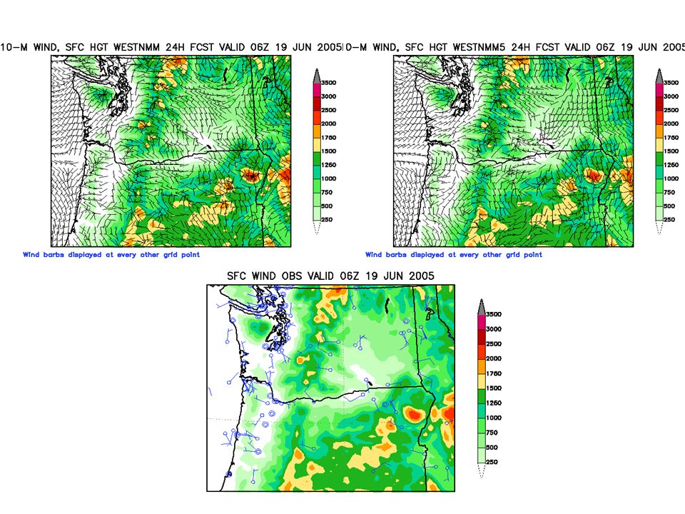
Matt Pyle’s Web Site Displaying 4.5 km WRF-NMM http://www.emc.ncep.noaa.gov/mmb/mmbpll/cent4km/ 30 hour forecast valid 06z 7 December, 2004

17
Web Site Now Displaying Simulated Reflectivity 12 hour forecast valid 12z 22 June, 2005

18
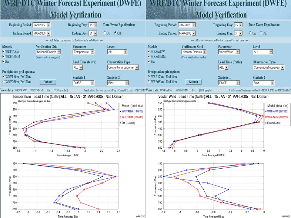
Prior Experience: DTC Winter Forecast Experiment Cold season (Jan-Mar 2005) runs –Both cores/controls run between NCAR & FSL –5 km resolution over full CONUS domain –Explicit configuration with no parameterized convection –Forecast fields distributed to NWS offices via FXNet –Full verification against observations & gages
 runs –Both cores/controls run between NCAR & FSL –5 km resolution over full CONUS domain –Explicit configuration with no parameterized convection –Forecast fields distributed to NWS offices via FXNet –Full verification against observations & gages")
19
FSL ran WRF-NMM and NCAR ran WRF-ARW –Both models initialized at 00 UTC from EDAS and made 48h forecasts NWS participation in DWFE design, evaluation, and reporting –Eastern, Southern, Central regions of NWS, some NWS/WR offices –Hydrometeorological Prediction Center Display of model forecast products –FX-Net, DTC website, and two-dimensional AWIPS displays VisitVIEW training on WRF and DWFE presented to NWS at outset Researchers and forecasters learning together how to use this fine- scale information and what model products are of greatest use Interactions between DTC and NWS 19

20
Examples of Phenomena Forecast by DWFE WRF Models from a presentation made by Steve Koch to OAR FSL also made available on its FX-Net system the ability to display the 8-10 km High- Resolution Window (HRW) domain WRF model runs from NCEP
 domain WRF model runs from NCEP")
21
0600 UTC Radar Mosaic Lake-effect snowbands Narrow Cold- Frontal Rainband Observed Composite Reflectivity at 03Z Narrow Reflectivity Bands: 23 January 2005 21 ARW 3-h forecast Composite Reflectivity Lake-effect snowbands Narrow Cold- Frontal Rainband

22
Topographically forced Pressure Waves and Snowbands in New England Blizzard: 23 January 2005 22 WRF-ARW 00Z 22Jan05 F27 988 Verifying 5-km Surface Mesoanalysis for 0300 UTC 995

23
Reflectivity Structures in Marine Boundary Layer: 23 January 2005 23 Cloud Streets Mesoscale Cellular Convection Marine Stratus

24
Mesoscale vortex over Lake Erie: 22 January 2005 ARW-5 18h Forecast for 1800 UTC 22Jan05 STMAS Analysis for 1900 UTC 22Jan05

25
DC Metro Snowstorm Bust: 27-28 February 2005 A comparison between two WRF forecasts made 24h apart demonstrating that the synoptic-scale must be forecast correctly as a necessary condition to predicting mesoscale structures accurately 25

26
WRF-NMM 42h Forecast of Mean Sea Level Pressure and 3-hour Accumulated Precipitation for 1800 UTC 28Feb05 shows strongly banded precipitation over Maryland and strong surface cyclone incorrectly positioned over southern Delmarva

27
WRF-NMM 18h Forecast of Mean Sea Level Pressure and 3-hour Accumulated Precipitation for 1800 UTC 28Feb05 shows disorganized precipitation over Maryland and weaker surface cyclone correctly positioned east of Hatteras

28
Loop of 3-hr QPF

32
Comparison of NCEP and RTVS methods for calculating ETS & Bias 95% confidence intervals using bootstrapping method are shown

33
DWFE Forecaster Feedback Pluses Minuses Allowed forecasters to gain experience using high-resolution WRF model output over a large domain in an operational fashion AWIPS and FX-Net display capabilities Novel radar reflectivity product –First time presented for winter weather –Useful for real-time verification against radar data –Made visualization of mesoscale features easier The ability to forecast mesoscale structures –Lake effect snow bands and other bands –Interaction of winter systems with terrain –Details offered HPC “tremendous advantage” over operational QPF –Predicted timing and placement of snowbands Conflicts with IFPS during active weather Only one run per day and 48h forecast too short a duration (limiting factors at HPC and for populating 5-km NDFD grids) Overprediction of orographic snowfall and in regions of instability (e.g., cold air outbreaks over Gulf Stream) WRF models tend to forecast features similar in appearance to (but with much greater detail than) the Eta model, to which they are slaved Global model forecast errors feed directly into errors in forecasts of fine-scale details in WRF models after a few hours Multi-scale display of upper-level fields?
 Overprediction of orographic snowfall and in regions of instability (e.g., cold air outbreaks over Gulf Stream) WRF models tend to forecast features similar in appearance to (but with much greater detail than) the Eta model, to which they are slaved Global model forecast errors feed directly into errors in forecasts of fine-scale details in WRF models after a few hours Multi-scale display of upper-level fields")
34
NCEP’s Explicit WRF HiResWindow Evaluation Parallel set of runs made for the four large HRW domains Parallel runs were made in near real-time Parallel runs were made reliably by NCO on Production side of CCS EMC turned over codes with final configuration to NCO in late May EMC produced extensive webpage showing comparisons of 5 km runs with existing runs

35
http://wwwt.emc.ncep.noaa.gov/mmb/mmbpll /hiresw5km.east08/index.html

36
Forecast Examples From Evaluation Period: Shelter Temperature 10 m Wind QPF

37
20-24C over central NJ and southeast PA

38
8 km NMM5 km NMM 8 km NMM forecast of 24-28C too warm

39
10 km ARW5 km ARW Both ARW runs too warm

40
34-38C over Phoenix region

41
8 km NMM 5 km NMM 8 km NMM forecast of 40-44C too warm 5 km NMM much closer

42
10 km ARW 5 km ARW Neither ARW too bad near Phoenix

45
5km QPF Comparison Plot Heavier showers in NMM5 than in EM5

46
“Big Picture” 5km Sfc Winds Comparison can’t see anything really meaningful

47
Local 5km Sfc Winds Comparison Plot Outflow beneath heavy showers approaching Lake Michigan

48
Local 5km Sfc Winds Comparison Plot Outflow beneath heavy showers approaching Lake Niagara

49
“Local” 5km Sfc Winds Comparison Plot Outflow beneath heavy showers in central New York state

50
3 h precipitation total (in.) 8 km operational WRF-NMM BMJ produces broad, smooth precipitation patterns in the current HRW
 8 km operational WRF-NMM BMJ produces broad, smooth precipitation patterns in the current HRW")
51
5.1 km parallel WRF-NMM 3 h precipitation total (in.) localized, more intense maxima generally less spatial coverage
 localized, more intense maxima generally less spatial coverage")
52
3 h precipitation total (in.) 10 km operational WRF-EM
 10 km operational WRF-EM")
53
3 h precipitation total (in.) 5.8 km parallel WRF-EM Turning off KF in WRF-EM has less dramatic impact, but spatial coverage of light precip is reduced.
 5.8 km parallel WRF-EM Turning off KF in WRF-EM has less dramatic impact, but spatial coverage of light precip is reduced.")
54
24 hr QPF Verification 8 km WRF-NMM versus 4.5km WRF-NMM SPC run 3/9/2005 to current ETS similar Bias larger in explicit run

55
NWS Central Region Evaluation Tom Hultquist No Evaluation of Retrospective Runs Real-Time Parallel Runs –There was not sufficient time/resources to make a thorough evaluation of the output. –However, attached are some comments compiled by WFO Omaha and some additional comments received from another office. –In general, favorable comments were received regarding the availability of additional runs which do not utilize a convective scheme.

56
NWS CR Evaluation Comments from Omaha WFO WRF Model Comparison Eastern Nebraska/southwest Iowa 21Z 10 June 2005 Temperatures –NMM5: The NMM5 model did a great job of forecasting the temperatures. It not only predicted the temperatures measured at 21Z within one or two degrees, it also was the only model to accurately anticipate a small area of warmer temperatures in northwestern Iowa. (RANK 1) –EM5: The calculations of the EM5 model for 21Z were quite a bit off the mark. It predicted that the temperatures in eastern Nebraska and western Iowa would range from the mid 80s to the lower 90s. However, the warmest temperature in the area, Storm Lake, Iowa, only reached 81 degrees. (RANK 3) –ARW: The ARW model was fairly accurate in forecasting the temperatures at 21Z. Like the NMM5 model, its predictions were within one or two degrees of the actual measurements. However, the ARW model failed to recognize the small area of warmer temperatures in northwestern IA. (RANK 2)
 –EM5: The calculations of the EM5 model for 21Z were quite a bit off the mark. It predicted that the temperatures in eastern Nebraska and western Iowa would range from the mid 80s to the lower 90s. However, the warmest temperature in the area, Storm Lake, Iowa, only reached 81 degrees. (RANK 3) –ARW: The ARW model was fairly accurate in forecasting the temperatures at 21Z. Like the NMM5 model, its predictions were within one or two degrees of the actual measurements. However, the ARW model failed to recognize the small area of warmer temperatures in northwestern IA. (RANK 2).")
57
NWS CR Evaluation Comments from Omaha WFO WRF Model Comparison Eastern Nebraska/southwest Iowa 21Z 10 June 2005 Precipitation (3hr totals) –NMM5: The NMM5 model predicted that at 21Z, a small band of <0.1” rain would stretch from southeastern Nebraska into extreme western IA. The actual precipitation amount ranged from a trace to 0.03” and occurred between Hastings and Tekamah. No rain fell in Iowa. (RANK 1) –EM5: The EM5 model did not forecast any precipitation at all. It did not recognize the potential for light precipitation and predicted dry conditions. (RANK 2) –ARW: The ARW model, on the other hand, over-estimated the potential for precipitation. It predicted spotty, light rain over eastern Nebraska and western Iowa, and a band of >0.5” precipitation over central IA. At 21Z, Iowa had not seen any rainfall at all. (RANK 3)
 –EM5: The EM5 model did not forecast any precipitation at all. It did not recognize the potential for light precipitation and predicted dry conditions. (RANK 2) –ARW: The ARW model, on the other hand, over-estimated the potential for precipitation. It predicted spotty, light rain over eastern Nebraska and western Iowa, and a band of >0.5 precipitation over central IA. At 21Z, Iowa had not seen any rainfall at all. (RANK 3).")
58
NWS CR Evaluation Comments from Omaha WFO WRF Model Comparison Eastern Nebraska/southwest Iowa 21Z 10 June 2005 CAPE –NMM5: The NMM5 model considerably underestimated the CAPE. It predicted CAPEs below 500 J/kg for the state of Nebraska and values of 500-1000 J/kg for western and central Iowa. At 21Z, the CAPEs over southeastern Nebraska and southwestern Iowa measured 1000-1500 J/kg and more than 2000 J/kg over central IA. (RANK 3) –EM5: The EM5 model did a fairly good job forecasting the CAPEs. It was the only model to accurately predict the higher CAPEs across southeastern Nebraska and southwestern Iowa, and the elevated CAPEs across central Iowa. (RANK 1) –ARW: The ARW model also predicted the areas of elevated CAPE but the forecasted values were about 500 J/kg lower than the observed 21Z conditions. (RANK 2)
 –EM5: The EM5 model did a fairly good job forecasting the CAPEs. It was the only model to accurately predict the higher CAPEs across southeastern Nebraska and southwestern Iowa, and the elevated CAPEs across central Iowa. (RANK 1) –ARW: The ARW model also predicted the areas of elevated CAPE but the forecasted values were about 500 J/kg lower than the observed 21Z conditions. (RANK 2).")
59
NWS CR Evaluation Comments from Omaha WFO WRF Model Comparison Eastern Nebraska/southwest Iowa 21Z 10 June 2005 CINH –OBSERVED: At 21Z, there was no CINH present over Iowa and the eastern half of Nebraska. Low values of CINH (<50 J/kg) could be found over the eastern half of Kansas and western third of Iowa. Strong CINH values were present over central Missouri and central Iowa. –NMM5: The NMM5 model predicted moderate values (200 J/kg) of CINH from northeastern Nebraska to south central Kansas. This model did not forecast any CINH for Iowa or Missouri. (RANK 3) –EM5: The EM5 model did not predict any CINH for Nebraska or western Iowa. In addition, it forecasted weak CINH for eastern Kansas (50-100 J/kg) and western Iowa with higher values (200-500 J/kg) for central Missouri and northward. (RANK 1) –ARW: The ARW model predicated low values of CINH (<100 J/kg) for eastern Nebraska and western Iowa and higher values for south central KS and north central Missouri. (RANK 2)
 could be found over the eastern half of Kansas and western third of Iowa. Strong CINH values were present over central Missouri and central Iowa. –NMM5: The NMM5 model predicted moderate values (200 J/kg) of CINH from northeastern Nebraska to south central Kansas. This model did not forecast any CINH for Iowa or Missouri. (RANK 3) –EM5: The EM5 model did not predict any CINH for Nebraska or western Iowa. In addition, it forecasted weak CINH for eastern Kansas ( J/kg) and western Iowa with higher values ( J/kg) for central Missouri and northward. (RANK 1) –ARW: The ARW model predicated low values of CINH (<100 J/kg) for eastern Nebraska and western Iowa and higher values for south central KS and north central Missouri. (RANK 2).")
60
NWS CR Evaluation Comments from Sullivan WFO We did a high resolution run of the MM5 at the University of Wisconsin Milwaukee with Dr. Paul Roebber a few years ago for the June 1997 flood. –There is an AMS article about this event. A copy is attached (see Section 3c. - Paul J. Roebber and John Eise. 2001: The 21 June 1997 Flood: Storm-Scale Simulations and Implications for Operational Forecasting. Weather and Forecasting: Vol. 16, No. 2, pp. 197–218.) –We tried 1.67 and 5 km resolutions and found that there was no where near the convective detail/intensity at 5 km than at 1.67 km. Basically, we didn't even get the right convection in the right area at 5 km and would have missed any potential for flash flooding completely. The MM5 we ran was non-hydrostatic, did not use a convective parameterization scheme and used a two way nested scheme where the various resolutions "felt" each other. I would love to see a short term high res grids in the first 24 hours down to 1.67 km and then run the rest at 5 km from that point on. Basically, higher resolution beyond 24 hours will only give us (in my humble opinion) a highly precise inaccurate solution. In the end, EMC can turn off convective parameterization -- it is more a hindrance than help at 5 km -- especially with a non-hydrostatic model. Of course, 1.67 km would be best :-)
 –We tried 1.67 and 5 km resolutions and found that there was no where near the convective detail/intensity at 5 km than at 1.67 km. Basically, we didn t even get the right convection in the right area at 5 km and would have missed any potential for flash flooding completely. The MM5 we ran was non-hydrostatic, did not use a convective parameterization scheme and used a two way nested scheme where the various resolutions felt each other. I would love to see a short term high res grids in the first 24 hours down to 1.67 km and then run the rest at 5 km from that point on. Basically, higher resolution beyond 24 hours will only give us (in my humble opinion) a highly precise inaccurate solution. In the end, EMC can turn off convective parameterization -- it is more a hindrance than help at 5 km -- especially with a non-hydrostatic model. Of course, 1.67 km would be best :-).")
61
NWS Central Region Recommendation Recommendation: Implement as proposed _X_

62
NWS ER Evaluation Comments from Josh Watson I went through the graphics to look at the performance for –a squall line event we had last Tuesday IN/OH –a nasty back-door cold front from New England through eastern NJ No models were able to forecast either of these two features correctly, even these two new HiRes runs. They seemed to do OK with Arlene, but I'll admit to not looking at that many fields for that event :-)
.")
63
NWS Eastern Region Recommendation Recommendation: Implement as proposed _X_

64
NCEP Service Center Evaluations HPC Pete Manousos Real-Time Parallel Run Subjective Evaluation: HPC evaluated NMM5 & EM5 by comparison to the NMM over 2 week period from 6-16 June 16 using real time parallel output from the web site http://wwwt.emc.ncep.noaa.gov/mmb/mmbpll/hiresw5km.east08/ http://wwwt.emc.ncep.noaa.gov/mmb/mmbpll/hiresw5km.east08/ Be mindful that evaluations were attempted from the single available run 10 out of the 12 days during this period. Output was not available 3 days due to run failures on Blue, therefore only 7 out of the 12 runs were evaluated. Additionally, QPF was the primary output parameter evaluated, although some mass fields were viewed as well.

65
NCEP Service Center Evaluations HPC Pete Manousos During this period, subjectively it was felt that the NMM5 output was generally an improvement over the NMM and even EM5 output. No significant differences were noted in phase of mass fields. However, the NMM5 seemed to be slightly more amplified in both directions (highs/lows warm/cold). This seemed more a function of the higher resolution of the NMM5 compared to the NMM, not a direct function of model accuracy. One concern noted was the overforecast of maxima from convection compared to observations - but note the areal coverage was not observed to be over forecast, just the amplitude (by about.25-.50"). The color scale for QPF made it very difficult to determine the exact amount overforecast.
. This seemed more a function of the higher resolution of the NMM5 compared to the NMM, not a direct function of model accuracy. One concern noted was the overforecast of maxima from convection compared to observations - but note the areal coverage was not observed to be over forecast, just the amplitude (by about ). The color scale for QPF made it very difficult to determine the exact amount overforecast..")
66
NCEP Service Center Evaluations - HPC Recommendation: Implement as proposed _X_

67
NCEP Service Center Evaluations SPC Steve Weiss Real-time AWC evaluation of was not performed: "Given our experience with the 4.5 km WRF- NMM over the last 14 months, plus detailed evaluations of explicit runs of the WRF-NMM and WRF-ARW during the last two Spring Experiments, we felt very comfortable supporting the proposed upgrade in the HRW. We did not think a relatively brief look at the parallel explicit runs would alter our findings.

68
NCEP Service Center Evaluations SPC Steve Weiss Reasons for supporting the upgrade to explicit WRF-NMM and WRF-ARW runs include: –Improved guidance on timing and location of convective initiation during potential severe weather episodes –Improved guidance on hourly evolution of mesoscale convective structures, including coverage, movement, and orientation of convective features –Unique information about convective mode or morphology, specifically related to mesoscale and near-stormscale structures of lines, discrete cells, and multicellular clusters, and the temporal/spatial evolution of convective mode –Unique information about higher order convective structures such as bow echoes and supercells, which produce a higher proportion of significant severe weather Although there remain important challenges in high resolution NWP (pbl, convective processes and initialization), our experience suggests that the current explicit versions of the WRF-NMM and WRF-ARW are sufficiently developed and tested to be run operationally in the HRW.
, our experience suggests that the current explicit versions of the WRF-NMM and WRF-ARW are sufficiently developed and tested to be run operationally in the HRW.")
69
NCEP Service Center Evaluations - SPC Recommendation: Implement as proposed _X_

70
Summary HiResWindow runs being upgraded to run at ~5 km resolution without calls to parameterized convection Thoroughly tested in 3 recent experiments in 2003- 2005 and applied to both warm & cold seasons New configuration produces better guidance on convective initiation, evolution and mode as well as extra detail for phenomena critical to local weather NCEP Service Centers recommend implementation NWS Regions recommend implementation Request NCEP Director concurrence to implement

Similar presentations


 Hydrometeorlogical Prediction Center (HPC) Forecast Operations Branch Winter Weather Desk Dan Petersen.>")


