Download presentation
Presentation is loading. Please wait.

2
Take out your binder, which should have at least 7 dividers in it Each Section goes with a corresponding unit which are as follows I. Geography: Its nature & Perspectives II. Population & Migration III. Cultural Geography IV. Political Geography V. Economic Geography VI. Rural Geography VII. Urban Geography

3
Each section will be divided into 2 parts First comes all of the Key Issues & handouts Then a section with loose leaf for notes and in- class assignments Your binders will be turned in with each Unit Test just like last semester It is your responsibility to make sure they are in order and contain all of the necessary documents

4
2 The Two Types of Geography Physical Geography –Topography –Climate (Koppen) –Flora and Fauna –soil Human Geography –Culture –Population –Economic –Political –Urban –Agriculture
 –Flora and Fauna –soil Human Geography –Culture –Population –Economic –Political –Urban –Agriculture")
5
Eratosthenes Calculated Earth’s circumference Coined the term “geography geo, earth, graphein, to write Ptolemy Wrote Guide to Geography the first book dedicated to the field Codified the basic principles of mapmaking by defining absolute location using latitude and longitude

6
World Map of the 2 nd century A.D. Scholar, Geographer (Claudius Ptolemaeus) Ptolemy
 Ptolemy")
7
Contemporary Geography Geographers ask where and why Location and distribution are important terms Geographers are concerned with the tension between globalization and local diversity

8
Geography’s Vocabulary Place – a specific point on Earth Region – Area of Earth distinguished by a distinctive combination of cultural and physical features Scale – The relationship between the portion of Earth being studied and Earth as a whole Space – Physical gap or interval between two objects Connections – Relationships among people and objects across the barrier of space

9
Absolute location or mathematical location is the exact latitude and longitude coordinates of a place. Relative location-the location of a place in relation to other physical or human features. Centrality-the function of location relative to urban places, resources, productive farmland and efficient transportation systems. Cities for example dominate their locations economically, politically and culturally thus displaying centrality.

10
geographers are concerned about the arrangement of features on the earth’s surface. 3 main properties of distribution are: Density-the frequency that something occurs in a given space. Concentration-changes in distribution-how close together-dispersed or clustered. Pattern-the arrangement of the distribution of features in a given space.

12
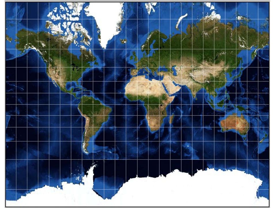
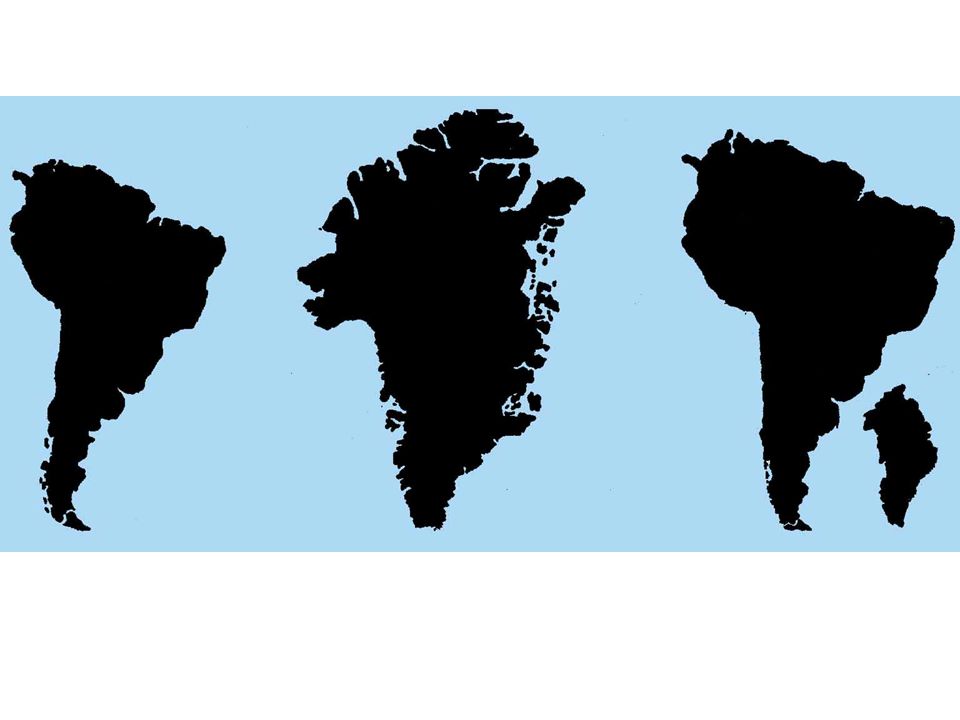
Problems Smaller than reality Curved earth is distorted when flattened Symbols used are limited Properties Scale Projection Symbols Gerhardus Mercator

16
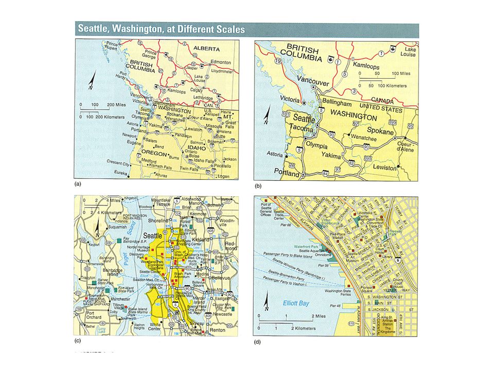
The relation of a feature’s size on the map to actual size. Small scale or small fraction maps show a large area on the earth such as 1/1,000,000. Large scale or large fraction maps show a small area on the surface such as 1/25,000 or 1/1000.

19
Isoline Maps-use lines of equal value to represent data like elevation, barometric pressure or temperature

20
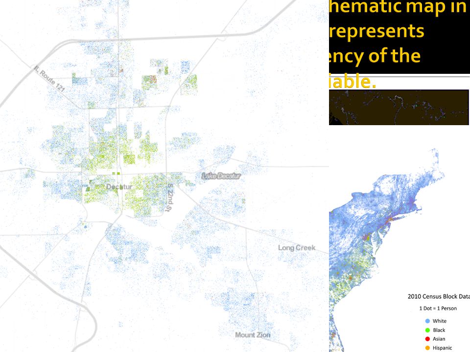
Choropleth Maps-a thematic map in which a variable is depicted with shading patterns or colors.

21
Proportional Symbol Map-a thematic map in which the size of the symbol varies in proportion to the intensity of the mapped variable.

23
Cartogram-a thematic map using relative size of units to convey a value.

24
GIS (Geographic Information Systems) Remote Sensing – uses satellites or planes to take still pictures of the earth’s surface GPS – uses multiple satellites and a person on the ground to convey absolute location
 Remote Sensing – uses satellites or planes to take still pictures of the earth’s surface GPS – uses multiple satellites and a person on the ground to convey absolute location")
25
The Township and Range System was created by the US Land Ordinance of 1785. Each township is divided into 36 sections each 1 mile by 1 mile and numbered 1 in the NE and 36 in the SE. The Homestead Act of 1863 encouraged the settlement of the West by giving each settler a quarter section or 160 acres of land.

Similar presentations


. Location – the space.>")


