Download presentation
Presentation is loading. Please wait.

1
Roamingwood Wellhead Protection Capture Zone Prepared by: Mr. Brian Oram, PG, MS Mr. Bill Toothill, MS Wilkes University Geo Environmental Sciences and Environmental Engineering Department http://www.wilkes.edu http://www.water-research.net

2
Project Location- Wayne County

3
Roamingwood Sewer and Water Well Field- Project Location

4
The Hideout Well 1 Well 6 Well 4 Well 3 Well 2 Well 5

5
Roamingwood Lake – The Hideout – Project Site Photo by: Roamingwood Water and Sewer Association

6
Roamingwood Well Field Well #Depth, ftYield, gpdDrastic Score 1496144,000147 2456208,800142 3495201,600155 4600345,600160 5525194,400160 665343,200139

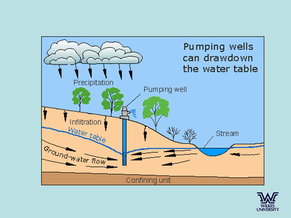
7
Hazard Evaluation Drastic Analysis Point and Non-Point Sources Physical Features –Shallow Depth to Rock –Fractured Zones –Wetland Area

8
Drastic Analysis Moderate (95 to 140); High (> 140) Well #Depth, ftYield, gpdDrastic Score 1496144,000147 2456208,800142 3495201,600155 4600345,600160 5525194,400160 665343,200139
; High (> 140) Well #Depth, ftYield, gpdDrastic Score , , , , , ,200139")
9
Shallow Depth to Bedrock Bedrock near Surface or Less than 2 feet Purple Areas – Shallow Depth to Bedrock Well 3 Well 4 Well 5 Well 6 Well 1 Well 2

10
Fractured Zones Fracture Trace / Linear Feature Well 1 Well 2Well 6 Well 5 Well 4 Well 3

11
Bedding Plane Fractures Jointing Photo by: Mr. Brian Oram (2004)
")
12
Wastewater Pumping Stations Well 1 Well 6 Well 2 Well 5 Well 4 Well 3 Pump Stations

13
Wastewater Pumping Stations Photo by: Mr. Brian Oram (2005)
")
14
Hazard Inventory

15
Fixed Radius Method R=( (Q*t)/(pi *n*H))^0.5 Time Frame t= 90 days, 1 year, 2 year, 5 year, 10 years For example, Well 5 t= 90 days, r = 232 feet t = 365 days, r = 466 feet t= 2 yr, r = 660 feet t= 5 yr, r = 1043 feet T = 10 yr, r = 1475 feet T = 90 days T = 10 years
/(pi *n*H))^0.5 Time Frame t= 90 days, 1 year, 2 year, 5 year, 10 years For example, Well 5 t= 90 days, r = 232 feet t = 365 days, r = 466 feet t= 2 yr, r = 660 feet t= 5 yr, r = 1043 feet T = 10 yr, r = 1475 feet T = 90 days T = 10 years")
16
Capture Zone Analysis Model Used – WinFlow Steady State – Transient Flow Model Referenced to Modflow Reference Head – 650 feet Gradient – 0.012 ft/d Porosity – 7 % (trail and error) K = 0.2 ft/d (Pump Test Data) Storage Coefficient – 1*e^-5 (confined system) Groundwater Discharge Rate - - 0.00026 ft/day (baseflow) Confining Layer – 200 feet below grade Screened – Fully Penetrating Saturated Thickness – 500 feet Direction of Flow – Southeast (315 degrees)
 K = 0.2 ft/d (Pump Test Data) Storage Coefficient – 1*e^-5 (confined system) Groundwater Discharge Rate ft/day (baseflow) Confining Layer – 200 feet below grade Screened – Fully Penetrating Saturated Thickness – 500 feet Direction of Flow – Southeast (315 degrees)")
17
Capture Zone Analysis The capture zone analysis was completed using the WinFlow Model. The area was divided into three separate zones. The zones were defined as follows: Zone I: Zone of Direct Influence- area where all groundwater is captured. Zone II: Zone of Capture- area were natural flow patterns are altered and contribute to the Zone I. Zone III: Contributes Water to the Zone II Area.

18
Background Groundwater Contour Map

20
Steady State Analysis Average Pumping Rate

21
Capture Zones Steady State Average Pumping Rate 13 MG/Month Zone 3 Zone 2 Zone 1

22
Capture Zones Steady State Peak Pumping Rate 20 MG/month Zone 3 Zone 2 Zone 1

23
Time Based Delineation

24
Recommendations For the Hideout Maintain Chemical Inventory and Improve Hazardous Waste Storage, Management, and Transport. Continue the STOP AND RECYCLED USED OIL FACT, Awareness Programs, other Educational Programs, and Hazardous Waste Disposal. Prohibit the use of Underground Fuel Storage or regulate the use. Encourage the use of water conservation devices. Minimize Site Disturbance and Provide Maximum Lot Coverage. Update Nutrient and Pesticide Management Plan for Golf Course. Encourage the Use of Rainwater Capture for Irrigation Use – Rather than Potable Water Use. Real-time monitoring of wells, including Well 6. Additional background monitoring of select wells for major cations and anions.

25
High Lot Coverage – Increase Runoff and Decrease Natural Recharge Paved Driveway – Roof runoff goes to driveway and immediately to road and stormwater system.

26
Low Lot Coverage / Natural or Enhanced Green Areas – Decrease Runoff and Promote Natural Recharge Lot Coverage – Gravel Driveway Photos by: Brian Oram (2005)
")
27
Recommendation Reach Out, Inform, and Educate Outside of the Hideout Local Well Ordinance (Siting, Construction, and Testing) Septic and Sludge Management Program Public Education – school students and new residents. Monitoring Select Private Wells within Zone II and Zone III. Stormwater Management System that promote Recharge

28
Private Well Ordinance Ordinance should address: Well Siting and Location Construction Standards Well Material Standards Well Grouting Initial Water Testing Image Source: Master Well Owner, Powerpoint Presentation

29
On-lot Disposal System Program Includes: Homeowner Education on System Operation and Maintenance Developing a Maintenance and Repair Program – Mandatory Septic Tank Pumping Developing a Septage / Sludge Management Ordinance

30
Individual / Community Stormwater Management Systems Example: Bioretention System for Stormwater Management

31
Roamingwood Wellhead Protection Capture Zone Prepared by: Mr. Brian Oram, PG Mr. Bill Toothill, MS Wilkes University GeoEnvironmental Sciences and Engineering Department http://www.wilkes.edu http://www.water-research.net http://www.wilkes.edu http://www.water-research.net

Similar presentations
 Pollution and Best Management Practices (BMPs) By: David Wojnowski, Stream Watch/Project WET Coordinator Stream.>")


>")


