Download presentation
Presentation is loading. Please wait.

1
Objectives For unit objectives see: Scope & Sequence

2
Weather Factors

3
Energy in the Earth’s Atmosphere

4
I.Energy from the Sun A. Electromagnetic waves (ondas electromagnèticas) 1. Waves that can transfer electric and magnetic energy through the vacuum of space 2. Classified according to wavelength, or distance between waves B. Radiation (radiación) 1. Direct transfer of energy by electromagnetic waves C. What types of Energy do we receive from the sun? 1. Visible and infrared radiation 2. Small amounts of UV
 1. Direct transfer of energy by electromagnetic waves C. What types of Energy do we receive from the sun. 1. Visible and infrared radiation 2. Small amounts of UV.")
6
Visible Light II. Visible Light (luz visible) A. All the colors that you can see in a rainbow Red, orange, yellow, green, blue, violet 1. Red, orange, yellow, green, blue, violet longest wavelengths 2. Red & orange longest wavelengths shortest wavelengths 3. Blue and violet shortest wavelengths

7
III. Non-Visible Radiation A. infrared radiation (radiación infrarroja) 1. Wavelengths that are longer than red light 2. Not visible 3. Can be felt as heat B. Ultraviolet radiation (radiación ultravioleta) 1. Invisible light with wavelengths shorter than violet light 2. Causes sun burns 3. Skin cancer 4. Eye damage
 1. Invisible light with wavelengths shorter than violet light 2. Causes sun burns 3. Skin cancer 4. Eye damage.")
8
IV. Energy in the Atmosphere A. Sunlight must pass through the atmosphere B. Absorbed or reflected by the atmosphere before hitting the Earth 1. Ozone layer 2. Water vapor & CO2 (some) 3. Clouds, dust, & other gases (some) a. Clouds act like mirrors b. Dust & gas scatters light C. Rest passes through to the surface
 3. Clouds, dust, & other gases (some) a. Clouds act like mirrors b. Dust & gas scatters light C. Rest passes through to the surface.")
11
V. Energy at Earth’s Surface A. Half (½) the sun’s energy reaches the surface B. This is absorbed by land and water. Changed into heat energy. C. When heated radiates energy back to atmosphere as infrared radiation 1. Greenhouse effect (efecto invernadero) a. Process by which gases hold heat in the air
 a. Process by which gases hold heat in the air.")
13
Heat Transfer

14
I.Thermal Energy & Temperature A. Temperature (temperatura) 1. Average amount of energy in motion of each particle of a substance 2. How hot or cold a substance is B. Thermal Energy (energía tèrmica) 1. Total energy of motion in the particles of a substance 2. Hot particles move fast – transferring energy http://mc2.cchem.berkeley.edu/Java/molecules/index.html
 1. Total energy of motion in the particles of a substance 2. Hot particles move fast – transferring energy")
15
II. Measuring Temperature A. Temperature (temperatura) 1. One of the most important factors effecting weather B. Thermometer (termómetro) 1. Thin glass tube filled with mercury or alcohol 2. Hot – molecules expand – very active 3. Cold – molecule contract – slow down
 1. Thin glass tube filled with mercury or alcohol 2. Hot – molecules expand – very active 3. Cold – molecule contract – slow down.")
16
III. Temperature Scales A. Measure in units called “degrees” B. Two common temperature scales 1. Celsius a. freezing point, 0 degrees C b. boiling point, 100 degrees C 2. Fahrenheit a. freezing point, 32 degrees F b. boiling point, 212 degrees F

17
IV. Converting Temperatures to Celsius Celsius = 5/9(Fahrenheit – 32) Activity: Solve these problems 35 F, 60 F, 72 F
 Activity: Solve these problems 35 F, 60 F, 72 F.")
18
V. How Heat is Transferred A. Three Ways 1. Radiation 2. Conduction 3. Convection

19
VI. Radiation (radiación) A. Warmth from the sun on your face B. Heat from the stove top (burner) C. Heat from a camp fire
 C. Heat from a camp fire.")
20
VII. Conduction (conducción) A. Direct transfer of heat from one substance to another that it is touching 1. When faster molecules touch slower molecules heat is transferred 2. The closer they are together the more effective they are http://www.harcourtschool.com/activity/states_of_matter/index.html

21
VIII. Convection (convección) A. The transfer of heat by the movement of fluid B. Convection currents (corriente de convección) 1. upward movement of warm air and downward movement of cold air
 1. upward movement of warm air and downward movement of cold air.")
23
Winds

24
I. What is wind? I. What is wind? horizontal movement of air high pressure low pressure A. horizontal movement of air from an area of high pressure to an area of low pressure B. Caused by differences in air pressure C. Differences in air pressure are caused by unequal heating of the atmosphere

25
Measuring Winds II. Measuring Winds A. Described by direction and speed B. Speed is measured by an anemometer 1. anemometer (anemómetro) C. Wind Chill Factor 1. increased cooling a wind can cause
 C. Wind Chill Factor 1. increased cooling a wind can cause.")
26
Lab – Making an Anemometer Make an Anemometer Students may make an anemometer to estimate wind speed from a fan, or an outdoor breeze, to get a relative “feel” for the force necessary to generate electricity.. Materials: scissors 4 small paper cups (like drinking cups) marker 2 equal strips of stiff, corrugated cardboard straight edge stapler push pin pencil with eraser modeling clay watch with second hand.
 marker 2 equal strips of stiff, corrugated cardboard straight edge stapler push pin pencil with eraser modeling clay watch with second hand..")
27
Lab Construction: Cut off the rolled edges of the paper cups to make them lighter Color the outside of one cup with the marker. Cross the cardboard strips so they are exactly perpendicular and staple together. Use the straight edge and pencil to draw lines from the outside corners of where the cardboard strips come together to the opposite corners. Where the pencil lines cross will be the exact middle of the cross. Staple the cups to the ends of the cardboard strips, making sure the cups all face the same direction. Push the pin through the center of the cardboard and attach the cardboard cross to the end of the eraser (see figure). Blow on the cups to ensure the cardboard spins around freely on the pin. Push the pencil into the clay so it sticks up straight. Use a fan or place the anemometer outside to catch the wind.
. Blow on the cups to ensure the cardboard spins around freely on the pin. Push the pencil into the clay so it sticks up straight. Use a fan or place the anemometer outside to catch the wind..")
28
Lab Measure wind speed: Using the watch, count the number of times the colored cup spins around in one minute. Professional anemometers convert revolutions per minute into miles or kilometers per hour. For purposes of this activity, assume that 100 rpms equals 10 miles per hour. (You can calculate this anemometer to measure actual wind speed: hold it out the window of a car traveling exactly 10 mph or km and count the revolutions in one minute.) Vary the placement of the anemometer and note the relative differences in wind speed. For example, indoors with a fan, outdoors between buildings, behind a tree, at different times of day, etc.
 Vary the placement of the anemometer and note the relative differences in wind speed. For example, indoors with a fan, outdoors between buildings, behind a tree, at different times of day, etc..")
29
Redesign Have students experiment with re-designed pinwheels. Divide the class in half and distribute additional paper. Have students re-design their pinwheels, with one half of the class making larger squares, and the other half smaller squares. What happens? Which re-design is more efficient? What are advantages to a smaller size (more mobile, takes less wind to move.). What are advantages to a larger size (captures more wind, need fewer towers).
. What are advantages to a larger size (captures more wind, need fewer towers)..")
30
Local winds III. Local winds short distances A. Winds that blow over short distances Caused by unequal heating B. Caused by unequal heating of the Earth’s surface within a small area 1. Only happen when large scale winds are weak Sea Breeze IV. Sea Breeze (brisa marina) Unequal heating large body of water A. Unequal heating often occurs along a shoreline or large body of water B. Takes more to warm up the body of water than the land. Cool air blows under the warm air C. Cool air blows under the warm air on land creating a sea breeze
 Unequal heating large body of water A. Unequal heating often occurs along a shoreline or large body of water B. Takes more to warm up the body of water than the land. Cool air blows under the warm air C. Cool air blows under the warm air on land creating a sea breeze.")
32
Land breeze V. Land breeze (brista terrestre) A. At night the process is reversed cool air from land beneath the warm air on the water B. Warm air over water rises, cool air from land goes beneath the warm air on the water

33
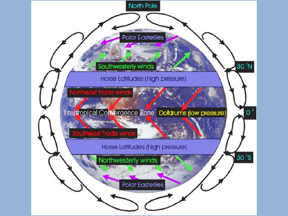
Global Winds VI. Global Winds (vientos globales) over long distances A. Winds that blow steadily from specific directions over long distances 1. Created the same way as local wind, but over long distances Coriolis Effect VII. Coriolis Effect (efecto de Coriolis) A. As air moves from high to low pressure in the northern hemisphere, it is deflected to the right by the Coriolis force. In the southern hemisphere, air moving from high to low pressure is deflected to the left by the Coriolis force.highlow
 A. As air moves from high to low pressure in the northern hemisphere, it is deflected to the right by the Coriolis force. In the southern hemisphere, air moving from high to low pressure is deflected to the left by the Coriolis force.highlow.")
34
Coriolis Effect

35
Global Wind Belts VII. Global Wind Belts A. Trade winds B. Polar easterlies C. Prevailing Westerlies

36
Doldrums VIII. Doldrums little or no wind A. Regions near the Equator where there is little or no wind 1. Caused by steady heating. Horse Latitudes XI. Horse Latitudes A. Warm air that rises at the Equator that divides and flows both north and south B. At 30 degrees north & south the air stops moving toward the poles and sinks Trade Winds X. Trade Winds A. Cold air over horse latitudes sink, producing high pressure area B. High pressure causes winds to blow toward the equator and away from it

37
Prevailing Westerlies XI. Prevailing Westerlies A. Between 30 and 60 degrees north and south winds blow towards the poles and turn east because of the Coriolis Effect B. Play an important role in weather in the U.S. Polar Easterlies XII. Polar Easterlies A. Cold air from the poles sinks and flows back towards the lower latitudes B. Coriolis Effect shifts these winds west C. Major effect on the weather in the U.S. Jet streams XIII. Jet streams A. 10 Kilometers above Earth’s surface B. High speed winds – 200 to 400 km per hour

39
Water in the Atmosphere

40
Water Cycle I. Water Cycle (ciclo del agua) A. Movement of water between the atmosphere and the Earth’s surface Water evaporates 1. Water evaporates Water vapors condense 2. Water vapors condense Water molecules form with particles in the air 3. Water molecules form with particles in the air Clouds form 4. Clouds form When heavy it rains, snows, or sleets 5. When heavy it rains, snows, or sleets Evaporation B. Evaporation (evaporación) 1. Process by which water molecules in liquid water escape into the air as water vapor
 1. Process by which water molecules in liquid water escape into the air as water vapor.")
42
Humidity II. Humidity (humedad) amount of water vapor A. Measure of the amount of water vapor in the air Relative humidity III. Relative humidity (humedad relativa) Percentage of water vapor in the air A. Percentage of water vapor that is actually in the air compared to the maximum amount of water vapor the air can hold at a particular temperature Example: 1. 10 degrees C, 1 cubic meter of air holds 8 grams of water vapor – Relative humidity 100%
 Percentage of water vapor in the air A. Percentage of water vapor that is actually in the air compared to the maximum amount of water vapor the air can hold at a particular temperature Example: degrees C, 1 cubic meter of air holds 8 grams of water vapor – Relative humidity 100%.")
43
IV. How clouds form

44
Types of Clouds V. Types of Clouds A. Classified into 3 main groups by shape Cirrus 1. Cirrus (cirros) Cumulus 2. Cumulus (cúmulos) Stratus 3. Stratus (estratos)
 Cumulus 2. Cumulus (cúmulos) Stratus 3. Stratus (estratos).")
45
Cirrus Clouds VI. Cirrus Clouds (cirros) A. Wispy, feathery B. Form only at high levels, 6 km C. Indicate fair weather 1. Cirrocumulus a. Indicates a storm is on the way

46
Cumulus Clouds VII. Cumulus Clouds (cúmulos) A. Fluffy, rounded piles of cotton B. 2 km to 18 km C. Small = fair weather D. Tall = storm on the way 1. Cumulonimbus – storm clouds

47
Stratus Clouds VIII. Stratus Clouds (estratos) A. Flat layer clouds B. Very thick and condensed C. Stormy weather 1. Nimbostratus a. Chance of rain, snow 100%

48
Fog IX. Fog A. Clouds near the ground

49
Precipitation

50
Precipitation I. Precipitation (precipitación) A. Any form of water that falls from the clouds that reaches the Earth’s surface Types of Precipitation II. Types of Precipitation A. Rain B. Sleet C. Freezing rain D. Snow E. Hail

51
Climate & Climate Change

52
What Causes Climate

53
I. Weather (tiempo meteorológico) A. Changes every day II. Climate (clima) A. Refers to the average, year after year conditions of temperature, precipitation, wind, and clouds in an area 1. California vs. Idaho vs. Virginia III. Microclimate (microclima) A. Local atmospheric zone where the climate differs from the surrounding area. 1. Hagerman vs. Sun Valley
 A. Refers to the average, year after year conditions of temperature, precipitation, wind, and clouds in an area 1. California vs. Idaho vs. Virginia III. Microclimate (microclima) A. Local atmospheric zone where the climate differs from the surrounding area. 1. Hagerman vs. Sun Valley.")
54
Factors Affecting Temperature IV. Factors Affecting Temperature Latitude A. Latitude (latitud) 1. Distance from the equator measured in degrees Altitude B. Altitude (altitud) 1. Elevation above sea level Distance from large bodies of wate C. Distance from large bodies of water Ocean currents D. Ocean currents
 1. Distance from the equator measured in degrees Altitude B. Altitude (altitud) 1. Elevation above sea level Distance from large bodies of wate C. Distance from large bodies of water Ocean currents D. Ocean currents.")
55
Latitude V. Latitude (latitud) A. Climates near the equator are warmer than areas away from equator Tropical Zone B. Tropical Zone 23.5 degrees north and 23.5 degrees south latitude 1. Area near the equator, between 23.5 degrees north and 23.5 degrees south latitude strike more directly 2. Sun’s rays strike more directly here

56
Polar Zones B. Polar Zones strike at an angle 1. Area where sun’s rays strike at an angle 2. Areas extend from 65 to 90 degrees north and south latitudes

57
Temperate Zones C. Temperate Zones summerstrike more directly 1. During summer, sun’s rays strike more directly winterstrike at low angles 2. During winter, sun’s rays strike at low angles hot summers cold winters 3. Weather results – warm to hot summers, cool to cold winters between tropical polar zones 4. Located between tropical and polar zones

58
Altitude D. Altitude height increases temperatures decrease A. As height increases temperatures decrease 1. Mt. Kilimanjaro 2. Temps decrease 6.5 degrees C for every km increase

59
Distance From Water E. Distance From Water A. Oceans make less extreme temperature changes Marine Climates 1. Marine Climates B. No oceans near 1. More extreme temperatures and drastic changes 2. Cold winters, hot summers Continental Climates 3. Continental Climates

60
Ocean Currents F. Ocean Currents

61
Factors Affecting Precipitatio V. Factors Affecting Precipitation Prevailing Winds A. Prevailing Winds 1. Winds that blow predominantly from a single general direction over a particular point on the Earth's surface. Mountain Ranges B. Mountain Ranges Windward A. Windward side of mountain 1. Warm air blows off the water 2. Cools and condenses as it rises a. More precipitation in mountains Leeward B. Leeward side of mountain 3. Air dries and warms as it falls 4. Little or no moisture on the other side

63
VI. Seasons A. Area caused by the tilt of the Earth’s axis as the Earth travels around the sun B. For Idaho 1. In June – we tilt closer to the sun 2. In December – we tilt farther from the sun

65
Climate Regions

66
I.Climate Classifications Temperature A. Temperature Amount of Precipitation B. Amount of Precipitation II. Climate Regions Tropical rainy A. Tropical rainy Dry B. Dry Temperate marine C. Temperate marine Temperate continental D. Temperate continental Polar E. Polar Highlands F. Highlands III. Tropical Rainy Climates Tropical Wet A. Tropical Wet Tropical Wet and Dry B. Tropical Wet and Dry

67
IV. Tropical Wet A. Found in low lying lands near the equator B. Many rainy days C. Year round heat D. Lots of rain E. Rain forests

68
Tropical Wet and Dry V. Tropical Wet and Dry A. Receive slightly less rain than tropical climates distinct dry season B. Have a distinct dry season Savannas C. Savannas 1. Africa

69
Dry Climates VI. Dry Climates A. When the amount of precipitation that falls is less than the amount that evaporates B. Include Arid 1. Arid Desert a. Desert Semiarid 2. Semiarid Steppes a. Steppes

70
VII. Arid Climates A. Deserts Regions of hot blazing heat and drifting sand dunes 1. Regions of hot blazing heat and drifting sand dunes Areas that are cold and rocky 2. Areas that are cold and rocky Receive less than 25 cm of rain per year 3. Receive less than 25 cm of rain per year Specialized plants 4. Specialized plants California, Great Basin, Southwest US a. California, Great Basin, Southwest US

71
VIII. Semiarid Climates A. Located on edges of deserts B. Called steppes 1. Dry but gets enough rainfall for short grasses and low bushes to grow 2. Prairies or grasslands a. The Great Plains

72
Temperate Marine Climates IX. Temperate Marine Climates A. Marine West Coast B. Humid Subtropical C. Mediterranean

73
X. Marine West Coast A. West Coast B. North of 40 degrees latitude and 40 degrees south latitude 1. Northern California, Southern Alaska C. Heavy precipitation D. Dense Forests

74
XI. Mediterranean A. Costal climate B. Drier and warmer than West Coast Marine C. Southern California, Mediterranean Sea D. 2 Seasons 1. Winter-cool and rainy 2. Summer-warm, little rain E. Dense shrubs, small trees

75
XII. Humid Subtropical A. Wet and warm B. Southeastern United States C. Hot summers – lots of rain D. Winters – cool and mild with rain E. Mixed forest areas – oaks, ash, hickory

76
Temperate Continental Climates XIII. Temperate Continental Climates Humid continental A. Humid continental 1. Very cold winters 2. Hot humid summer 3. Moderate rainfall in summer 4. Small amounts of precipitation in Winter a. Northeastern US Subarctic B. Subarctic 1. Short cool summers 2. Long bitter cold winters a. Alaska, Canada

77
Polar Climates XIV. Polar Climates A. Ice caps Antarctica 1. Found mainly on Greenland and Antarctica 2. Mostly below freezing 3. Limited vegetation Tundra B. Tundra 1. Alaska, Canada, Russia 2. Short cool summers, bitter cold winters 3. Soil is always frozen permafrost a. permafrost aa. Makes soil boggy in summer

78
Highlands XV. Highlands A. Areas where temperatures falls as altitude increases B. Surrounding areas tend to be warmer C. Precipitation increases as altitude increases 1. Rocky Mountain foothills

79
Long – Term Climate Change

80
Studying Climate Change I. Studying Climate Change A. In studying ancient climates, scientists follow an important principle: If plants or animals today need certain conditions to live, then similar plants and animals in the past also required those conditions

81
Tree Rings I. Tree Rings study ancient climates A. Used to study ancient climates

82
Ice Ages II. Ice Ages (glaciación) A. Climate has gradually changed throughout history B. Warm Periods glacial episodes C. Ice Ages (glacial episodes) 1. This is when huge sheets of ice called glaciers covered large parts of the Earth’s surface D. Have been about 3 ice ages 10,500 years E. Last Ice Age ended about 10,500 years ago 1. Northern Europe, North America
 1. This is when huge sheets of ice called glaciers covered large parts of the Earth’s surface D. Have been about 3 ice ages 10,500 years E. Last Ice Age ended about 10,500 years ago 1. Northern Europe, North America.")
84
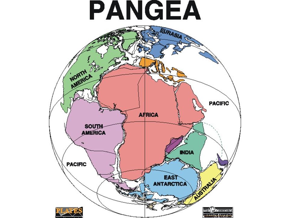
Causes of Climate Change III. Causes of Climate Change Earth’s position A. Earth’s position 1. Belief is Earth’s axis has tilted slightly over time Solar Energy B. Solar Energy 1. Increased sunspots – more solar energy 2. After 11 year cycle they decrease Volcanic Activity C. Volcanic Activity 1. Much gas and ash released into atmosphere 2. Filtering solar radiation, may lower temps Movement of Continents D. Movement of Continents 1. Pangaea

Similar presentations


>")


