Download presentation
Presentation is loading. Please wait.

1
Multiple ways of Learning about Antarctica with Cybercartography Sebastien Caquard, Peter Pulsifer and D.R. Fraser Taylor

2
Overview of the presentation What is cybercartography? Alternative ways of learning with cybercartography The cybercartographic atlas of Antarctica

3
What is cybercartography?

4
A large research project: “Cybercartography & the New Economy” - Directed by Prof. D.R.F. Taylor - 2.6 M$ funded by Social Sciences and Humanities Research Council of Canada (SSRHC) - 4 years (started 01/2003) - About 50 people from different disciplines
 - 4 years (started 01/2003) - About 50 people from different disciplines.")
5
What is cybercartography? Cybercartography is multiple: - Multidisciplinary (Geo / Psycho / Sciences cog / Literature) - Multi partners (e.g. Atlas of Canada, Industry Canada, SCAR) - Multimedia - Multisensory - Multi users (general public, policy makers, scientists) - Multi topic (beyond geographical topics)
 - Multi partners (e.g. Atlas of Canada, Industry Canada, SCAR) - Multimedia - Multisensory - Multi users (general public, policy makers, scientists) - Multi topic (beyond geographical topics).")
6
What is cybercartography? => Combination production/research for education Outcomes expected - 2 Cybercartographic Atlases (Antarctica & Trade) - Research (proofs of concept) (e.g. Internet Cartography / Open Standards Cartography / Interoperability / Formal Ontologies / Multimedia Cartography / Archiving digital data / Understanding the User (UNA) / Usability / Multisensory / Sound maps / Art and Cybermaps / Technologies for the Blind / Situational Awareness in Virtual Spaces / Navigation in Informational Spaces / Cognitive Theories / Learning Theories / Multidisciplinary / Gaming and engagement / Hypertext and live hypernarrative)
 - Research (proofs of concept) (e.g. Internet Cartography / Open Standards Cartography / Interoperability / Formal Ontologies / Multimedia Cartography / Archiving digital data / Understanding the User (UNA) / Usability / Multisensory / Sound maps / Art and Cybermaps / Technologies for the Blind / Situational Awareness in Virtual Spaces / Navigation in Informational Spaces / Cognitive Theories / Learning Theories / Multidisciplinary / Gaming and engagement / Hypertext and live hypernarrative).")
7
Multiple ways of learning The Cybercartographic Atlas of Antarctica

8
A comprehensive atlas of Antarctica - Designed for High school students - To communicate scientific information - In an engaging manner - Using elements of cybercartographic - As well as to develop critical perspectives

9
The Cybercartographic Atlas of Antarctica A multidisciplinary approach - Human factor psychology: User Interface design - Geography (+ sciences): Content development - Computer science: Computer model development - English literature / Art : Critical perspective - Cognitive sciences / Psychology: Evaluation
: Content development - Computer science: Computer model development - English literature / Art : Critical perspective - Cognitive sciences / Psychology: Evaluation")
10
The Cybercartographic Atlas of Antarctica Analyze the needs (Education and Psychology) Image by A. Parush - HOTLab - 2005 - Designed based on the UNA - The user/student is central - Iterative process: analysis, development, evaluation

11
The Cybercartographic Atlas of Antarctica Develop the content (Geography / Scientists) - Following UNA and curriculum - Compiling scientific information (modules: e.g. exploration) - Using some elements of cybercartography (e.g. multimedia) - Multi-authors
 - Using some elements of cybercartography (e.g. multimedia) - Multi-authors.")
12
The Cybercartographic Atlas of Antarctica Develop the technology (Computer sciences / Geomatics) - Interoperability - Module interconnected - Open source technology - Follow the UNA - Highly interactive - Easily usable - Easy to update => Developing an atlas framework
 - Interoperability - Module interconnected - Open source technology - Follow the UNA - Highly interactive - Easily usable - Easy to update => Developing an atlas framework")
13
The Cybercartographic Atlas of Antarctica A first prototype:

14
The Cybercartographic Atlas of Antarctica Evaluation: usability testing - Assess navigation, terminology, features and functionality - 7 undergraduate students - Rapid learning curve - Problem with Key UI (e.g. terminology, association map/text, web page model) - Not very engaging => Overall recommendations to improve the EFFECTIVENESS
 - Not very engaging => Overall recommendations to improve the EFFECTIVENESS.")
15
Alternative ways of learning with cybercartography

16
- Modification and repurpose of an existing game - Teach about (1) Antarctica environment; (2) global warming ; (3) scientific process - Different perspectives - Engaging manner Improving the engagement: Developing a mod game Game developed by J-P Fiset - GCRC - 2004 Alternative ways of learning
 Antarctica environment; (2) global warming ; (3) scientific process - Different perspectives - Engaging manner Improving the engagement: Developing a mod game Game developed by J-P Fiset - GCRC Alternative ways of learning")
17
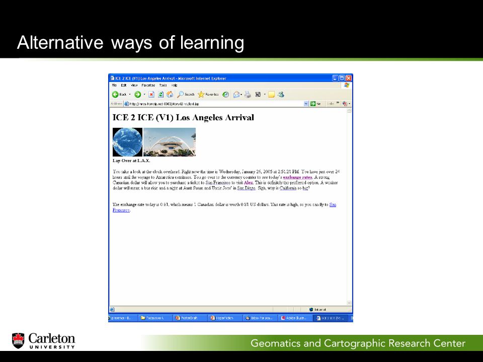
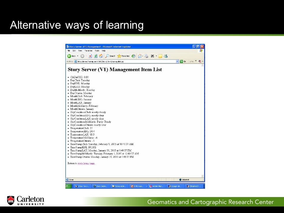
- Narrative + Hypertext + Live elements - Content and structure determined by live information - Standard Java Server Pages - Engaging story to learn about Antarctica Live hypernarrative Alternative ways of learning

18
Prototype developed by R. Biddle - HOTlab - 2004 Alternative ways of learning

27
- Engaging way to access information - High level of interaction - Providing changing/multiple perspectives - Different ways of learning (Affective/Incidental) Mod game / Live hypernarrative: => Complementary to the effectiveness of the atlas Alternative ways of learning
 Mod game / Live hypernarrative: => Complementary to the effectiveness of the atlas Alternative ways of learning")
28
Conclusion

29
Multiplicity of cybercartography: - Different ways to present info beyond traditional cartography - Different ways to access info (e.g. maps, game) - Different ways of learning (Effective / Affective / Incidental) - Better adapted to the diversity of the students (MI theory) - Better adapted to the Internet environment - Better adapted to develop critical thinking
 - Different ways of learning (Effective / Affective / Incidental) - Better adapted to the diversity of the students (MI theory) - Better adapted to the Internet environment - Better adapted to develop critical thinking.")
30
Conclusion Remaining challenges - Integrate proofs of concept in the atlas design (e.g. live hypernarrative as the introduction of the atlas) - Evaluation: How do we evaluate affective learning? - Reconsider the way of teaching with cybermaps: how can we capture users attention in the Internet environment?
 - Evaluation: How do we evaluate affective learning. - Reconsider the way of teaching with cybermaps: how can we capture users attention in the Internet environment .")
Similar presentations


 XXVII SCAR, Shanghai, PRC July 2002.>")


