Download presentation
Presentation is loading. Please wait.

1
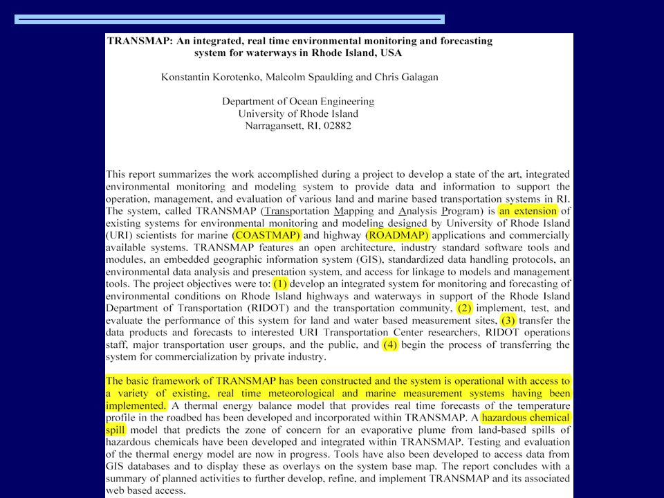
TRANSMAP - an integrated, real time environmental monitoring and forecasting system for waterways in in Rhode Island, USA Konstantin Korotenko Malcolm. Spaulding Chris Calagan University of Rhode Island, USA 2001

2
Rhode Island

3
Outlines About TRANSMAP TRANSMAP is based on PORTS, COFS, RIDOT and RWIS systems General Architecture of PORTS (data) Structure of COFS (data) Structure of RIDOT (data) TRANSMAP system for Rhode Island
 Structure of COFS (data) Structure of RIDOT (data) TRANSMAP system for Rhode Island")
5
Data Acquisition in PORTS

6
PORTS provides…..

7
Architecture of PORTS for Rhode Island

10
TRANSMAP Architecture

11
PORTS Data Receiver

12
PORTS Data Receiving GUI

13
RIDOT Data Receiving GUI

14
Wind speed and direction based on PORTS and COFS data Feb 22, 2001 17:45

15
Surface current velocity based on PORTS and COFS data Feb 22, 2001 01:00

16
Air Temperature based on PORTS, RWIS and COFS data Feb 22, 2001 14:30

17
SSS contours based on PORTS and COFS data Feb 21, 2001 18:00

18
SST contours based on PORTS and COFS data Feb 21, 2001 18:00

19
Water Level contours based on PORTS and COFS data Feb 21, 2001 18:00

20
GIS data overlaid on the study base map Feb 21, 2001 18:00

21
Applications based on TRANSMAP Operational Models for predicting: Pollution Transport and Dispersal in the Sea Transport of Warfare Chemicals Dumped at the Sea Bottom Road Icing

22
http://adsabs.harvard.edu/abs/k..

23
Particle tracking technique in an operational system for the prediction of pollution from warfare chemicals dumped the Baltic Sea Konstantin Korotenko P.P. Shirshov Institute of Oceanology Moscow, Russia kkoroten@yahoo.com John and Katherine MacArthur Foundation

24
Sites of Dumping in the Baltic Sea Table. Locations and quantity of warfare chemicals dumped in the Baltic Sea. Location Munitions Quantity, tons Chemical Agent Type Bornholm basin 60,2 Clark I, Clark II, Adamsite, chloroacetophenone Gotland basin 2,3 Clark-I, Clark-II, Adamsite, chloroacetophenone Southeast of Gotland Isl. 6,4 Arsenic-containg agents, Adamsite, Mustard, chloroacetophenone Little Belt 5,8 Phosgene, Tabun Skagerrak 270,1 Phosgene, Tabun, Adamsite, Mustard chloroacetophenone

25
Extension: Road Icing Prediction

26
Thermal Energy Balance Output

27
MERCI

Similar presentations


>")


 obtained using binary logistic regression.>")
 Model Input>")


 Erik Buch Centre for Ocean and Ice.>")


