Download presentation
Presentation is loading. Please wait.

1
Baltic Operational Oceanographic System (BOOS) Erik Buch Centre for Ocean and Ice
 Erik Buch Centre for Ocean and Ice")
2
Traffic volumes in the Baltic Sea

4
The Baltic Sea Marine Transportation © Finnish Institute of Marine Research, 2006

5
Oil Drift Forecast on request Drift of oil and floating objects Back tracking facility Fu Shan Hai

6
Areas requiring Operational Oceanographic Services in the Baltic Shipping - all kinds Navigation in shallow areas and entrances to harbours Rescue operations, drift forecasting Military purposes Storm surge warnings Flood protection Coastal protection Transport calculations of water, substances and passive biological material, e.g. algae and fish eggs

7
Areas requiring Operational Oceanographic Services in the Baltic Bottom water renewal, oxygenation Environmental protection, impact assessment and management Ecosystem assessment Fisheries planning and management Recreation purposes Public warnings Research

8
Baltic Operational Oceanographic System BOOS BOOS is a formal association of institutes from Sweden, Finland, Russia, Estonia, Latvia, Lithuania, Poland, Germany and Denmark taking national responsibility for operational oceanographic services, which shall support the protection of lives and properties and the promotion of the development of society 17 Member Institutes and 3 associate members

9
BOOS Vision The vision of BOOS is to provide an integrated service to marine users and policy makers in support of safe and efficient off-shore activities, environmental management, security, and sustainable use of marine resources. BOOS aims to develop a single system for operational monitoring and forecasting of the Baltic Sea and a co- ordinated network of coastal systems. The systems will merge and assimilate diverse data from space-borne sensors and in situ measurement networks in order to monitor the Baltic Sea physics, biogeochemistry and ecosystems and to provide forecasts on prediction time scales ranging from days to months.

11
German Bouy stations contributing to BOOS LT - Kiel Fehmarn Belt Darss‘ Sill OderbankArkona

12
DATA EXCHANGE

13
Water level stations

14
Waves

15
Daily and weekly maps of Sea Surface Temperature

16
Forecasting Waterlevel Waves Temperature Salinity Currents Sea Ice

17
Transport calculations

18
WWW.BOOS.ORG

19
Member web-pages Inflow events, Sea Surface Temperatures & Sea Ice Maps

20
Member web-pages Daily Algae Watch Products

22
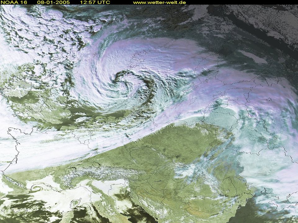
Storm ”Gudrun” 8-9 January 2005

23
Oceanographic Forecasts as Daily Products at several service providers

24
Storm ”Gudrun” 8-9 January 2005 Oceanographic Forecasts as Daily Products at several service providers

26
Sea level 48-hour forecasts compared to measurements in the Gulf of Riga Days Sea level height (cm)
")
27
HELCOM Agreement on cooperation BOOS contribution to HELCOM Annual Indicator reports on: –Development of Sea Surface Temperature –Water exchange between the Baltic Sea and the North Sea and conditions in the deep basins –Runoff to the Baltic Sea regions and total runoff –Sea Ice

Similar presentations


>")


 Why new? Because: Too little focus on clear objectives and specific products Products and services.>")

 Harvey Seim / University of North Carolina at Chapel Hill University.>")


