Download presentation
Presentation is loading. Please wait.

1
1. Appreciate connections among Asia, Europe, and Africa. 2. Locate regions that were part of the Silk Road network (China, India, Central Asia, Persia, Mediterranean, Arabia). 3. Describe physical conditions (climate, deserts, mountains) along the Silk Road. 4. List important economic goods and cultural ideas that traveled along the Silk Road. Silk Roads – Geographic Objectives Students will able to:
. 3. Describe physical conditions (climate, deserts, mountains) along the Silk Road. 4. List important economic goods and cultural ideas that traveled along the Silk Road. Silk Roads – Geographic Objectives Students will able to:.")
2
Silk Roads - Vocabulary Merchant Monk Bandit ---------------------------------------------------------------- Silk cloth Glass Spices Heavenly horses Ivory Cotton cloth ---------------------------------------------------------------- Buddhism Islam ---------------------------------------------------------------- Caravan Bactrian camel Dromedary camel ---------------------------------------------------------------- Oasis Port city

3
Silk Roads - Resources This lesson is based on content found in The Silk Route, 7000 Miles of History by John S. Major Other books for children: -- We’re Riding on a Caravan, An Adventure on the Silk Road by Laurie Krebs -- Stories from the Silk Road by Cherry Gilchrist -- Caravan to America, Living Arts of the Silk Road by John S. Major & Betty J. Belanus (and forward by Yo-Yo Ma)
.")
4
Where were the world’s largest cities during Silk Road times?

5
Where were the largest cities in the Year 100?

6
Where were the largest cities in the Years 500 and 1000?

7
Silk Road towns connected the largest cities of the West and East in 500 and 1000 CE. West East

8
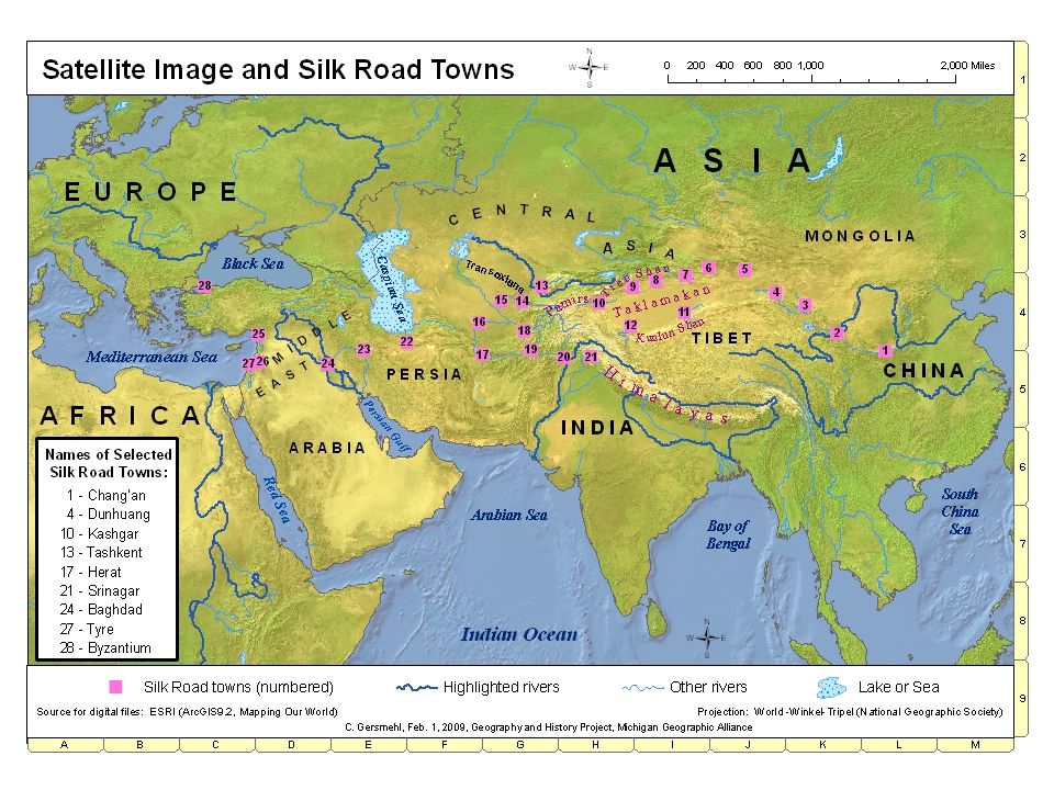
In this satellite image, the green color tells us about vegetation. Green areas have enough water for trees and crops. Which colors indicate drier areas or deserts? We will explore the Silk Roads using a satellite image.

9
Our Silk Roads journey starts in China in the Year 700. In the Chinese city of Chang’an (#1), merchants load silk, paper, and herbal medicines onto two-humped Bactrian camels.
, merchants load silk, paper, and herbal medicines onto two-humped Bactrian camels..")
10
Between Chang’an (#1) and Dunhuang (#4): Bandits from Mongolia or Tibet may attack caravans. Therefore, Chinese soldiers must travel with the caravans.

11
Dunhuang (#4) is an important Buddhist religious center. Buddhist monks from India traveled along the Silk Road and brought Buddhism to China.

12
Taklamakan Desert (“if you go in, you won’t come out”): Caravans must travel through this desert before the heat of summer hits.
: Caravans must travel through this desert before the heat of summer hits.")
13
Rivers carry melted snow down from high mountains! High, snow-covered mountains surround the Taklamakan. Oasis towns are located along the edges of the Taklamakan Desert.

14
Kashgar (#10) is an oasis town, where local merchants trade their dates, melons, and grapes for silk that the caravans bring from China.
 is an oasis town, where local merchants trade their dates, melons, and grapes for silk that the caravans bring from China.")
15
Pamir Mountains (between #10 and #13): The route through these mountains is called the “Trail of Bones” because the route is dangerously steep and cold.
: The route through these mountains is called the Trail of Bones because the route is dangerously steep and cold.")
16
Pamir Mountains: At elevations higher than 10,000 feet (3000 meters), it is extremely cold, and there is no food for the animals.
, it is extremely cold, and there is no food for the animals.")
17
The highest elevations are purple and dark gray. Pamir Mountains: Between Kashgar (#10) and Tashkent (#13), caravans climbed the “Trail of Bones” through the high, cold Pamirs.
 and Tashkent (#13), caravans climbed the Trail of Bones through the high, cold Pamirs..")
18
In Tashkent (#13), Chinese military use silk to purchase the strong horses raised in the grasslands of Central Asia. Tashkent (#13)
.")
19
Low precipitation: Notice the low rainfall regions inside Asia.

20
In Tashkent (#13), local merchants sell fine locally made wool carpets as well as glass objects and musical instruments that have come from Europe, Middle East, and the Middle East.
, local merchants sell fine locally made wool carpets as well as glass objects and musical instruments that have come from Europe, Middle East, and the Middle East.")
21
#20 and #21 send spices and cotton cloth from India and precious stones from Ceylon into Silk Road routes.

22
In Herat (#17), an Islamic mosque looms over the city market. Arabs brought the Muslim religion to Silk Road towns. Dromedary camels from Arabia are used from here westward.

23
In Baghdad (#24), ivory, gold, and spices from Africa and pearls from the Persian Gulf are exchanged for silk.
, ivory, gold, and spices from Africa and pearls from the Persian Gulf are exchanged for silk.")
24
Tyre (#27): Goods are loaded onto ships in this port city on the Mediterranean Sea.
: Goods are loaded onto ships in this port city on the Mediterranean Sea.")
25
Our journey ends at the edge of Europe. In Byzantium (#28), few people know where China is, but wealthy people want the silk that has traveled along the Silk Roads.
, few people know where China is, but wealthy people want the silk that has traveled along the Silk Roads..")
26
In 500 and 1000 CE. Silk Road towns connected the largest cities of the West and East.

27
Silk Roads - PICTURES and QUESTIONS – Explore goods and religions that moved along the Silk Road. Explore dangers and difficulties of Silk Road travel. Carol Gersmehl, June 18, 2009 (These pictures are not copyrighted.) Geography and History Project: Michigan Geographic Alliance; NY Geographic Alliance Use these pictures along with a map: BW_SilkRoads-Towns map.pdf
 Geography and History Project: Michigan Geographic Alliance; NY Geographic Alliance Use these pictures along with a map: BW_SilkRoads-Towns map.pdf.")
28
1 – What goods and ideas moved along Silk Roads trade routes?

30
The Chinese military traveled 1000s of miles to reach Central Asia (near #13). What did they want to purchase there? ____________________________________________

31
The Chinese learned how to raise “silk worms” and how to unwind silk thread from their cocoons. The Chinese kept this process a secret! Find China and also Central Asia on the map: What cloth did Central Asians want to buy from China? _____________________

32
Find China and the Middle East (#23 - #27) on the map: What did the Chinese want to buy that was “hand blown” in the Middle East. ______________________

33
Find areas near #2 through #21 on the map: An important religion traveled from India to Silk Road towns and to China. What was this religion? _________________ These are monks

35
Minaret and mosque in Bukhara Find areas near #13, 14, 15, 16 on the map: Another important religion traveled from Arabia to Central Asia. What was this religion? ____________________

37
2 - What difficulties and dangers did travelers face during the journey between East and West?

38
Mongolian archer Find #2 through #5 on the map: What dangers did travelers have to prepare for? __________________

39
Find #4 (Dunhuang) on the map: What dangers did caravans face in this desert region? _____________________________ What Desert is #4 next to? ________________ How high are these sand dunes compared to an apartment building?

40
Find the area near #6 (Turpan) on the map: Caravans would stop at an oasis for water and food. How does water come to an oasis? Where does the water come from? _________________ Paul Harwood traveled the former Silk Road route and shares this photo of an oasis (Turpan). Notice contrast of dry and watered. The green vegetation is in an oasis.
. Notice contrast of dry and watered. The green vegetation is in an oasis..")
41
Find the areas just west of #10 (Kashgar): What difficulties and dangers did travelers face in these extremely high mountains? _________________________________

43
Pamir Mountains Find the Taklamakan Desert (near #6 through #12 on the map): How did mountain snow help towns around the edges of the desert? _________________________ Hint: The small green spots are oasis towns.

45
Dromedary camels carried heavy loads along the western routes - between #17 and #27. Bactrian camels carried heavy loads along the eastern routes – between #1 and #17. How are these two types of camels different from each other? _________________________

46
These photos and pictures were found using the Internet. One photo (Turpan oasis) is from Paul Harwood who traveled the Silk Road in 2005. If you use his photos, particularly beyond classroom-educational use, you must give him credit. The following files provide internet source information: c.Internet_Links for Silk Road Pictures.xls and also d.Internet_National Geographic Photos.doc The PowerPoint file called SilkRoads#8b-Satellite images-Takalamakan has satellite images from NASA.
 is from Paul Harwood who traveled the Silk Road in If you use his photos, particularly beyond classroom-educational use, you must give him credit. The following files provide internet source information: c.Internet_Links for Silk Road Pictures.xls and also d.Internet_National Geographic Photos.doc The PowerPoint file called SilkRoads#8b-Satellite images-Takalamakan has satellite images from NASA..")
47
Thank you for your time and participation!! 35-59 81 st St Jackson Heights, New York 11372 718-803-0060

Similar presentations