Download presentation
Presentation is loading. Please wait.

1
Cities and Civilizations
World History Ch. 2 Early River Civilizations

2
GEOGRAPHY influenced the development of river valley civilizations.

3
CIVILIZATION Advanced Cities Advanced Technology Specialized Workers
Record- Keeping Complex Institutions

4
Mesopotamia – Fertile Crescent
Sumer – The Earliest of the River Valley Civilizations Sumerian Civilization grew up along the Tigris and Euphrates Rivers in what is now Kuwait.

5
Look at the map in the textbook on page 30. “Fertile Crescent.”

7
Geography Promotes Civilization
Fertile area between the Tigris and Euphrates rivers became site of world’s first civilization Fertile Crescent well suited for agriculture Farming in Mesopotamia posed challenges: If water levels too high, crops washed away If water levels too low, crops died People developed methods to control water: Basins, canals, and dikes Organization: assigning jobs, allocating resources

8
Religion and Government
Sumer Shaped life in city-states Polytheism: worship of many gods Priests had high status and were the first rulers War chiefs began to rule as kings Dynasty: series of rulers from one family Religion and Government

10
Sumerian Culture Writing Math and Sciences The Arts Trade and Society
Cuneiform: Sumerian writing Business accounts and records Law, grammar, literature Scribes Math and Sciences System based on number 60 Geometry May have been the first to use the wheel Invented the plow Basic surgery The Arts Arches, ramps, columns Sculpture Cylinder seals Trade and Society Traded for wood and metals Social hierarchy Distinct male/female roles

11
Empires in Mesopotamia
Each conquering invader adapted aspects of Sumerian culture. Thus Sumerian civilization continued to influence life in Mesopotamia. Sargon I: Around 2350 BC, created first permanent army Conquered Sumer and northern Mesopotamia Established world’s first empire, which lasted about 100 years Sumerian culture spread far beyond Tigris and Euphrates valleys Sargon’s Empire Hammurabi became king in 1792 BC United all of Mesopotamia Able ruler and administrator Hammurabi’s Code: 282 laws covering everything from trade to murder Written for all to see Babylon became Mesopotamia’s greatest city The Babylonian Empire

13
Sumer - Sumerians (Kuwait) ca. 3500 to 3000 BC. (ca. = circa)
Sumer gave us the city-state. Define: city-state Political unit made up of a city and the surrounding lands. Each city state has its own government, even when it shares a culture with neighboring city states. Sumer - Sumerians (Kuwait) ca to 3000 BC. (ca. = circa)
 ca to 3000 BC. (ca. = circa)")
14
Sumerian Writing: cuneiform
. Sumerian Writing: cuneiform Cuneiform is created by pressing a pointed stylus into a clay tablet.

15
Sumerians invented: Brick technology Wheel
Base 60 – using the circle degrees Time – 60 minutes in an hour, 60 seconds in a minute 12 month lunar calendar arch ramp ziggurat

16
Ziggurat – Holy Mountain

17
“If a man stole the property of church or state, that man shall be put to death; also the one who received the stolen goods from his hand shall be put to death.” The laws governed such things as lying, stealing, assault, debt, business partnerships, marriage, and divorce. In seeking protection for all members of Babylonian society, Hammurabi relied on the philosophy of equal retaliation, otherwise known as “an eye for an eye.”

18
Because of the geography of the area.
Ch. 2 Sect. 2 What did Herodotus mean when he said that Egypt is the “gift of the Nile?” Nile River Because of the geography of the area. Sahara Desert

20
The Geography of Egypt Environmental Challenges
• Light floods reduce crops, cause starvation • Heavy floods destroy property; deserts isolate and protect Egyptians Upper Egypt and Lower Egypt • River area south of First Cataract is elevated, becomes Upper Egypt • Cataract—where boulders turn Nile River into churning rapids • River area north, including Nile delta, becomes Lower Egypt • Delta—land formed by silt deposits at mouth of river; triangular NEXT

21
Nile River

22
Click the icon to play Listen to History audio.
Click the icon below to connect to the Interactive Maps.

23
Geography and Early Egypt
The Nile Most important physical feature in Egypt 4,000 miles long; flows through the Sahara Desert Without the Nile’s waters, no one could live there. Geography of Egypt The Nile flooded every year Predictable floodwaters with spring rains Left rich, black silt Narrow band of fertile soil Became home of Egyptian civilization

24
Geographical Features
Egypt’s most fertile soil in Nile Delta Silt deposits at mouth of river Black Land of rich arable soil Red Land unlivable but afforded protection Delta Nile afforded protection itself Flowed through cataracts to the south Currents and waterfalls made sailing impossible Not an easy invasion route Cataracts

25
How did geography affect where the early Egyptians lived?
Draw Conclusions How did geography affect where the early Egyptians lived? Answer(s): They lived in a narrow strip of fertile land where they could raise crops. It was surrounded by inhospitable desert, which would not easily support life.
: They lived in a narrow strip of fertile land where they could raise crops. It was surrounded by inhospitable desert, which would not easily support life.")
26
Egypt Unites into a Kingdom
King Narmer Creates Egyptian Dynasty • Villages of Egypt ruled by two kingdoms—Lower Egypt, Upper Egypt • King Narmer unites them around 3000 B.C.; makes Memphis capital • Establishes first Egyptian dynasty Pharaohs Rule as Gods • To the Egyptians, kings are gods; Egyptian god kings called pharaohs • Pharaohs control religion, government, army, well-being of kingdom • Government based on religious authority— theocracy Continued . . . NEXT

27
Egyptians invented: Hieroglyphics Pyramids Geometry
Advances in medicine and surgery

29
Religion and Life •Egyptians believe in 2,000 gods and
goddesses—polytheistic •Re is sun god, Osiris, god of the dead; goddess Isis is ideal woman • Believe in life after death; person judged by deeds at death

30
Egyptian Writing In hieroglyphics writing system, pictures represent ideas Paperlike sheets made from papyrus reeds used for writing Papyrus is one of the first examples of paper. It is created from reeds growing along the Nile River.

31
Hieroglyphics Sacred Carving
Early Egyptian writing found on tombs was indecipherable. Hieroglyphics Sacred Carving No one could read these sacred carvings until Napoleon invaded Egypt and his archaeologists found the Rosetta Stone.

32
In ancient Egypt, scribes used hieroglyphs to record state documents and important historical events. Hieroglyphs with religious purposes also were painted on tomb walls and wooden coffins, such as these hieroglyphs from the tomb of Queen Amonherkhepsef, located in the Valley of the Queens.

33
The ancient Egyptians decorated tombs with paintings and reliefs to ensure that the deceased spent eternity in a comfortable and familiar environment. This relief, from the 5th Dynasty (2465 bc-2323 bc), shows the deceased seated at a table stacked with offerings of food.
, shows the deceased seated at a table stacked with offerings of food..")
34
Ancient Egyptian Mummy

35
Rosetta Stone

36
Ch. 2 Sect. III Review 1. Which direction does the Nile flow? North
2. What do we call a government based on religion? Theocracy 3. What is the Egyptian god king called? Pharoah 4. What is the belief in many gods? Polytheism 5. What do we call the Egyptian writing? Hieroglyphics

37
Indus River Valley (page 53) 2500 BC – 1500 BC Ch. 2 Sect. III
Around 2600 B.C. the various regional cultures were united in what is called the Indus Valley Civilization. It is also commonly referred to as the Harappan culture after the town of Harappa (where it was first discovered.) What made the Indus Valley a good place for a civilization?
 What made the Indus Valley a good place for a civilization")
39
Planned Cities on the Indus
The Geography of the Indian Subcontinent Indian Subcontinent • Subcontinent—landmass that includes India, Pakistan, and Bangladesh • World’s tallest mountain ranges separate it from rest of Asia Rivers, Mountains, and Plains • Mountains to north, desert to east, protect Indus Valley from invasion • Indus and Ganges rivers from flat, fertile plain—the Indo-Gangetic • Southern India, a dry plateau flanked by mountains • Narrow strip of tropical land along coast Continued . . . NEXT

40
The Geography of the Indian Subcontinent
Monsoons • Seasonal winds—monsoons—dominate India’s climate • Winter winds are dry; summer winds bring rain can cause flooding Environmental Challenges • Floods along the Indus unpredictable; river can change course • Rainfall unpredictable; could have droughts or floods NEXT

41
Civilization Emerges on the Indus
Indus Valley Civilization • Influenced an area larger than Mesopotamia or Egypt Earliest Arrivals • About 7000 B.C., evidence of agriculture and domesticated animals • By about 3200 B.C., people farming in villages along Indus River Planned Cities • By 2500 B.C., people build cities of brick laid out on grid system • Engineers create plumbing and sewage systems • Indus Valley called Harappan civilization after Harappa, a city NEXT

42
What do the planned cities of the Indus Valley people tell us about their culture?
High level of cooperation, strong central government What skills were needed to build these planned cities? Central gov. building materials, engineering and architectural skills

43
Harappan Culture Language
• Had writing systems of 400 symbols; but scientists can’t decipher it Culture • Harappan cities appear uniform in culture; no great social divisions • Animals important to the culture; toys suggest prosperity NEXT

44
• Had thriving trade with other peoples, including Mesopotamia
Role of Religion • Priests closely linked to rulers • Some religious artifacts reveals links to modern Hindu culture Trade • Had thriving trade with other peoples, including Mesopotamia Harappan Decline • Signs of decline begin around 1750 B.C. • Earthquakes, floods, soil depletion may have caused decline • Around 1500 B.C., Aryans enter area and become dominant NEXT

45
Mohenjo-Daro

46
Excavations at the ancient Harappan and Mohenjo Daro mounds revealed well planned cities and towns built on massive mud brick platforms that protected the inhabitants against seasonal floods. In the larger cities the houses were built of baked brick while at smaller towns most houses were built of sun-dried mud brick. Each city is laid out in a grid pattern and shows signs of stunningly modern plumbing systems. Much writing has been found at these sites, but it has not yet been translated.

47
Sect. III Review 1.What environmental challenges do the people of the Indus face? Yearly floods, rivers change course, monsoons unpredictable too much rain or not enough. 2. Was the geography of Mesopotamia or Egypt more like that of the Indus Valley? Mesopotamia b/c the floods were unpredicable. 3. What environmental challenges did the people of the Indus face that the first 2 didn’t? The Monsoons

48
Shang China 1600 BC – 1122 BC Ch. 2 Sect. IV
Lack of contact with foreigners helped give the Chinese a strong sense of identity and superiority. They regarded their land as the only civilized land and called it Zhongguo or the Middle Kingdom. This Chinese isolation contributed to the Chinese belief that China was at the center of the earth and the sole source of civilization.

49
North, South , East, West Natural barriers isolated China from all other civilizations. Mongolian Plateau Taklimakan Desert Gobi Desert Plateau of Tibet Pacific Ocean Himalaya Mountains

50
China: Size and Population
Click Red Stars to find more information. China: Size and Population China United States 9,596,960 Square area 9,629,091 Square area 1,284,303,705 Population 280,562,489 Population The population of China is more that one billion people, the largest national group in the world. Two-thirds of the Chinese people are farmers, but only 4% of China’s land can be cultivated. In an effort to balance the relationship between land and people, China adopted a “one-couple, one-child” policy in the 1980’s. US Agricultural Production

51
River Dynasties in China
The Geography of China Barriers Isolate China • Ocean, mountains, deserts isolate China from other areas River Systems • Huang He (“Yellow River”) in north, Yangtze in south • Huang He leaves loess—fertile silt—when it floods Environmental Challenges • Huang He floods can devour whole villages • Geographic isolation means lack of trade; must be self-sufficient China’s Heartland • North China Plain, area between two rivers, center of civilization NEXT
 in north, Yangtze in south. • Huang He leaves loess—fertile silt—when it floods. Environmental Challenges. • Huang He floods can devour whole villages. • Geographic isolation means lack of trade; must be. self-sufficient. China’s Heartland. • North China Plain, area between two rivers, center. of civilization. NEXT.")
52
China’s Geography The development of civilization in early China was aided by features like long rivers, fertile soils, temperate climates, and isolated valleys. China’s first civilizations developed in river valleys Two major rivers supplied water for earliest civilizations Chang Jiang, also called Yangzi Huang He, or Yellow River Both flow east from Plateau of Tibet to Yellow Sea Rivers, Soils, Climates Annual floods deposited rich soil, loess, on flood plains Valley of Huang He particularly fertile due to loess Fine dusty soil Carried into China by desert winds Loess

53
Crops Most of eastern China covered with fertile soils; some regions better suited than others for growing certain crops Southern China—warm, receives plenty of rainfall, excellent region for growing rice Further north—climate cooler, drier; suitable for grains, wheat, millet Isolation Combination of rivers for irrigation, fertile soil for planting allowed Chinese to thrive, as did China’s relative isolation Mountains, hills, desert protected China from invasion Himalaya Mountains separate southern China from India, rest of southern Asia; vast Gobi Desert prevented reaching China from west

54
Yellow River Takes its name from the vast quantities of loess soil it picks up along its route Loess is an extremely fine and powder-like soil that gradually builds up in the river bed, raising the river bed and forcing the water out of its established path Yellow River periodically unleashes terrible floods, earning it the nickname “China’s Sorrow”

55
Yellow River

56
Civilization Emerges in Shang Times
The First Dynasties • Around 2000 B.C. cities arise; Yu, first ruler of Xia Dynasty • Yu’s flood control systems tames Huang He (“Yellow River”) • Shang Dynasty, 1700 to 1027 B.C., first to leave written records Early Cities • Built cities of wood, such as Anyang—one of its capital cities • Upper class lives inside city; poorer people live outside • Shang cities have massive walls for military defense NEXT
 • Shang Dynasty, 1700 to 1027 B.C., first to leave written records. Early Cities. • Built cities of wood, such as Anyang—one of its capital cities. • Upper class lives inside city; poorer people live outside. • Shang cities have massive walls for military defense. NEXT.")
57
What geographic features influenced life in early China?
Summarize What geographic features influenced life in early China? Answer(s): Rivers deposited rich soil for farming; mountains, hills, and desert isolated the area.
: Rivers deposited rich soil for farming; mountains, hills, and desert isolated the area.")
58
Timeline Event B.C. The Xia (Shay) dynasty emerged. Its leader was a mathemetician named YU. He used irrigation and flood control. Event to 1027 B.C. The Shang dynasty emerges. They were the first family of Chinese rulers to leave written records.

59
Event 3 Anyang One of the capitals of the Shang. Anyang was built mainly of wood.

60
Cities: Anyang Vast network of walled towns whose local rulers recognized authority of the Shang kings Shang rulers moved their capital six times Capital at Yin (near modern Anyang) contained a complex of royal palaces and eleven large and lavish royal tombs Royal tomb at Anyang
 contained a complex of royal palaces and eleven large and lavish royal tombs. Royal tomb at Anyang.")
61
The Development of Chinese Culture
Chinese Civilization • Sees China as center of world; views others as uncivilized • The group is more important than the individual Family • Family is central social institution; respect for parents a virtue • Elder males control family property • Women expected to obey all men, even sons Social Classes • King and warrior-nobles lead society and own the land Continued . . . NEXT

62
The Development of Chinese Culture
Religious Beliefs • Spirits of dead ancestors can affect family fortunes • Priests scratch questions on animal bones and tortoise shells • Oracle bones used to consult gods; supreme god, Shang Di Development of Writing • Writing system uses symbols to represent syllables; not ideas • People of different languages can use same system • Huge number of characters make system difficult to learn NEXT

63
Oracle bones

64
Chinese Coins

65
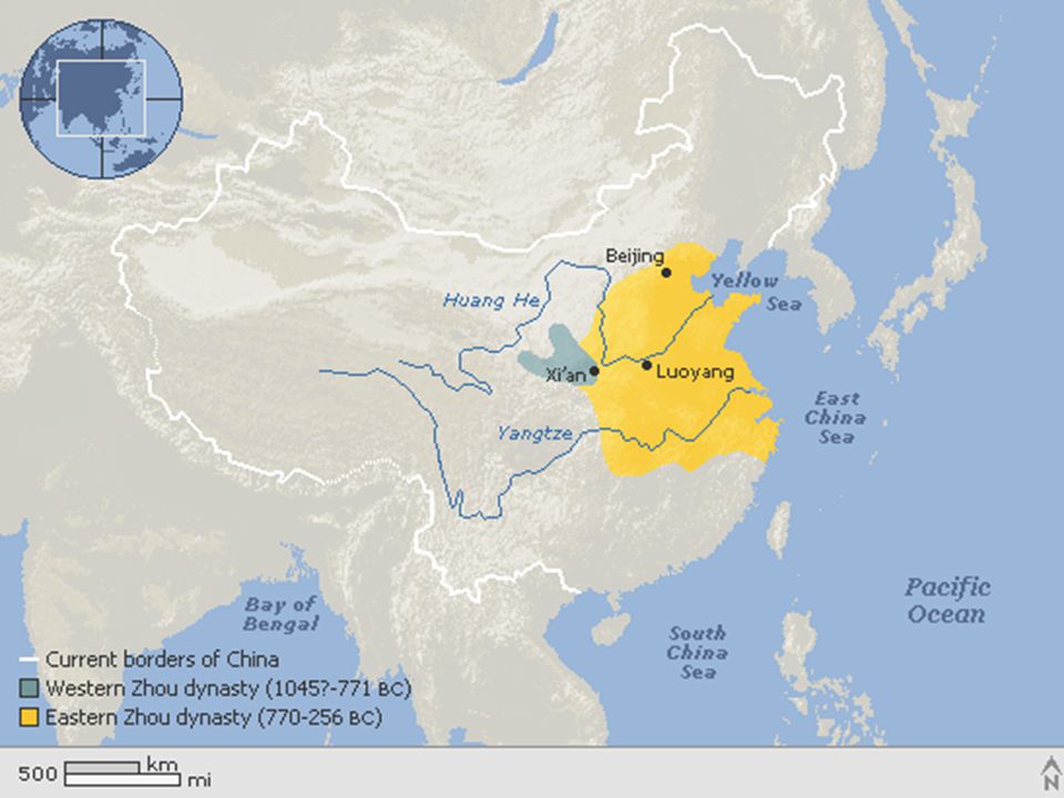
Fish shaped money The Chinese Zhou dynasty (1045?-256 bc) helped pave the way for the unification of China by the subsequent Qin dynasty ( bc). During the Zhou period, farming techniques improved, iron became widely utilized for tools and weapons, and Confucianism and Daoism (Taoism) gained widespread popularity.
 helped pave the way for the unification of China by the subsequent Qin dynasty ( bc). During the Zhou period, farming techniques improved, iron became widely utilized for tools and weapons, and Confucianism and Daoism (Taoism) gained widespread popularity.")
66
Event 4 Development of Writing
The advantage of the Chinese system of writing was that people all over China could learn the same system of writing, even if their spoken language were very different. This helped unify China.

68
Zhou and the Dynastic Cycle
The Zhou Take Control • In 1027 B.C., Zhou Dynasty takes control of China Mandate of Heaven • Mandate of Heaven—the belief that a just ruler had divine approval • Developed as justification for change in power to Zhou • Dynastic cycle—pattern of the rise and decline of dynasties Control Through Feudalism • Feudalism—system where kings give land to nobles in exchange for services • Over time, nobles grow in power and begin to fight each other NEXT

69
Event B.C. to 256 B.C. Zhou overthrew the Shang and established the Zhou dynasty. Event B.C. Nomads from the north and west sack the Zhou capital only a few royal members survive. They flee to new capital at Luoyang.

70
Zhou and the Dynastic Cycle
Improvements in Technology and Trade • Zhou Dynasty builds roads, canals to improve transportation • Uses coins to make trade easier • Produces cast iron tools and weapons; food production increases A Period of Warring States • Peaceful, stable Zhou empire rules from around 1027 to 256 B.C. • In 771 B.C., nomads sack the Zhou capital, murder monarch • Luoyang becomes new capital; but internal wars destroy traditions NEXT

71
What geographic features influenced life in early China?
Summarize What geographic features influenced life in early China? Answer(s): Rivers deposited rich soil for farming; mountains, hills, and desert isolated the area.
: Rivers deposited rich soil for farming; mountains, hills, and desert isolated the area.")
Similar presentations


 in Chapter 2 Section 2 that are new to you. Already know.>")


