Download presentation
Presentation is loading. Please wait.

1
Access to products from the SWFDP-EA RSMC, Nairobi web portal
Vincent N. Sakwa KMD

2
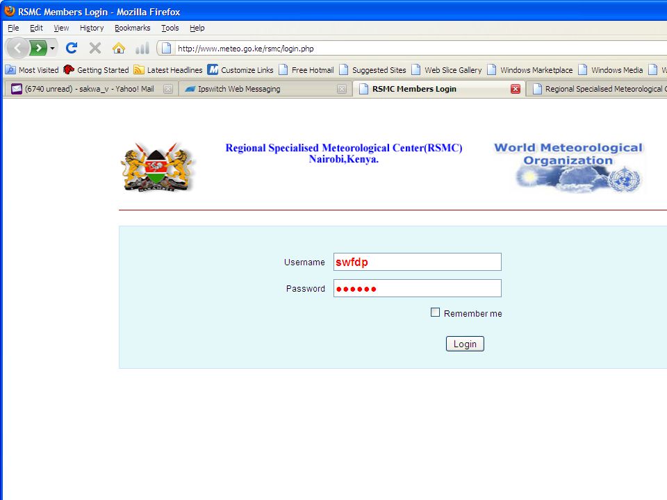
Login page http://www.meteo.go.ke/rsmc/index.php
Username: swfdp Password: swfdp1

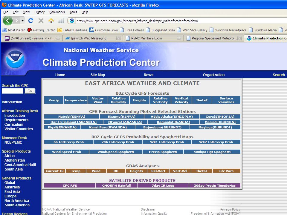
5
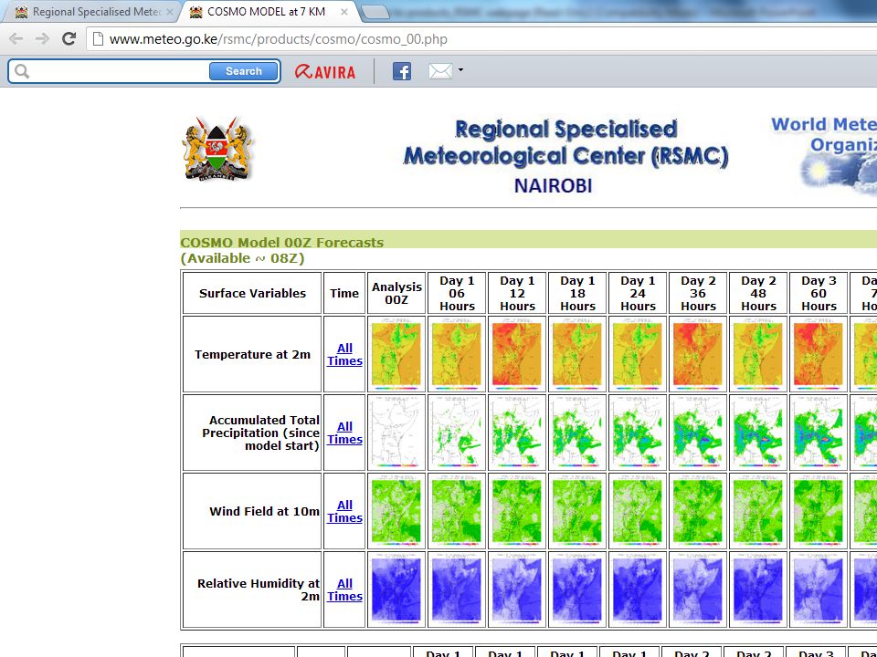
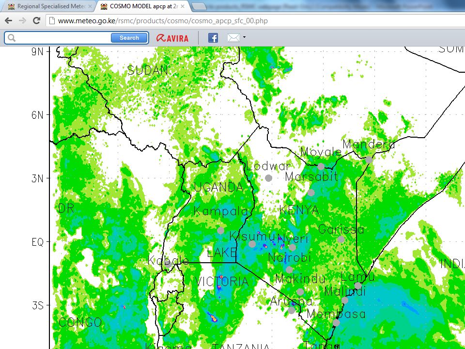
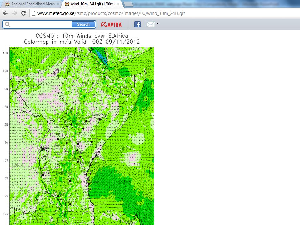
NWP MODELS-REGIONAL PRODUCTS
COSMO(7km) WRF(7km) LAKE VICTORIA PRODUCTS ALADIN LA RE-UNION INDIAN OCEAN WAVES UK MET OFFICE LAM MET OFFICE EPS
 WRF(7km) LAKE VICTORIA PRODUCTS. ALADIN LA RE-UNION. INDIAN OCEAN WAVES. UK MET OFFICE LAM. MET OFFICE EPS.")
9
GLOBAL PRODUCTS NOAA EA PRODUCTS ECMWF PRODUCTS UK MET PRODUCTS
TIGGE-GIFS East Africa products for

11
GUIDANCE PRODUCTS Short range forecasts (1-2 days)
Medium range forecasts (3-5 days) Agrometeorology Products (5days) Satellite products Evaluation Form
 Agrometeorology Products (5days) Satellite products. Evaluation Form.")
14
Risk tables Indicate areas where severe weather is expected, ‘X’ if it applies for the entire area, otherwise specified. Eg. S coast Risk categories: No risk, Low, Medium or High

15
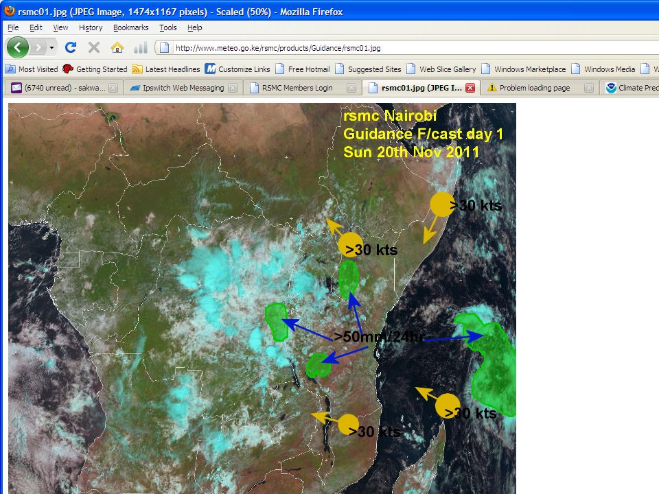
SWFDP GUIDANCE PRODUCTS RISK TABLES
RSMC-NAIROBI SWFDP GUIDANCE PRODUCTS RISK TABLES SHORT-RANGE (DAY 1 AND DAY 2) Issue Date: Saturday 19th November 2011 In order to provide more information about the geographical location of the severe event the following convention is adopted when filling in the cells: X for the whole country, N for the northern part, S for the southern part, W for the western part and E for the eastern part. Day 1: Saturday 19th November 2011 Heavy Rain Strong Winds RISK No risk Low risk Medium risk High risk X DRC N,E S
 Issue Date: Saturday 19th November In order to provide more information about the geographical location of the severe event the following convention is adopted when filling in the cells: X for the whole country, N for the northern part, S for the southern part, W for the western part and E for the eastern part. Day 1: Saturday 19th November Heavy Rain. Strong Winds. RISK. No risk. Low risk. Medium risk. High risk. X. DRC. N,E. S.")
16
SWFDP GUIDANCE PRODUCTS SHORT-RANGE (DAY 1 AND DAY 2)
RSMC-NAIROBI SWFDP GUIDANCE PRODUCTS SHORT-RANGE (DAY 1 AND DAY 2) Issue Date: 19th November 2011 Valid for: 19th to 20th November 2011 Showers and thunderstorms expected over several places in the region as indicated in the risk table. Degree of confidence: High Day 2: Sunday 20th November 2011
 Issue Date: 19th November Valid for: 19th to 20th November Showers and thunderstorms expected over several places in the region as indicated in the risk table. Degree of confidence: High. Day 2: Sunday 20th November")
17
Links to International Centers
ECMWF NCEP UK MET OFFICE WMO DWD KMA RSMC-PRETORIA ICPAC ICMWF ACMAD AGRHYMET

18
Regional and International Centres
ECMWF NCEP UKMO WMO RSMC-Reunion ACMAD

19
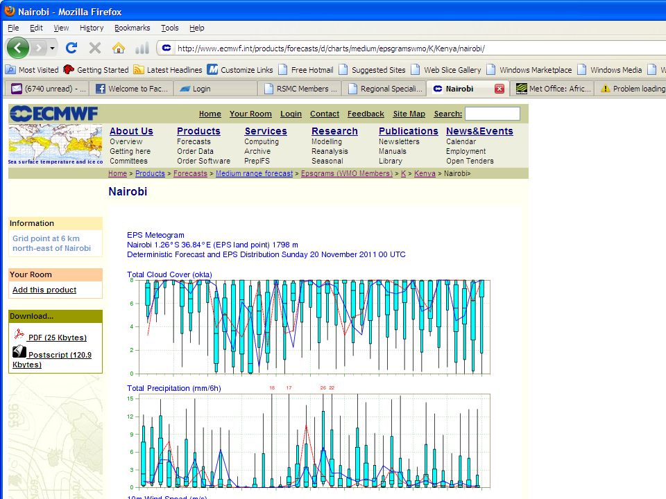
Met Office Global and Regional Ensemble Prediction System (MOGREPS)
Products that can be provided include: Site specific “Meteograms”. Precipitation threshold probability charts. Windspeed threshold probability charts. Spaghetti Diagrams. Tropical cyclone tracks forecasts.

21
Links to National Met Services
Kenya Ethiopia Rwanda Tanzania Uganda Burundi

22
Limited Area Model for Africa: Africa-LAM
Fields available include: Accumulated precipitation (6 and 24-hour) Outgoing longwave radiation Pressure at mean sea level Wet bulb potential temperature at 850 mbar Temperature at 1.5m, 925hPa, 700hPa Wind at 10m, 850hPa, 700hPa, 200hPa Relative humidity at 925hPa, 700hPa
 Outgoing longwave radiation. Pressure at mean sea level. Wet bulb potential temperature at 850 mbar. Temperature at 1.5m, 925hPa, 700hPa. Wind at 10m, 850hPa, 700hPa, 200hPa. Relative humidity at 925hPa, 700hPa.")
23
Limited Area Model for Africa: Africa-LAM
How can you get it? Through a password protected website The user name is afr_nms, and the password is uk_alam. (ii) The forecast fields are available through EUMETCAST using satellite receiver stations. This allows the data to be viewed using forecaster workstations.
 The forecast fields are available through EUMETCAST using satellite receiver stations. This allows the data to be viewed using forecaster workstations.")
24
NCEP NWP Products Spaghetti diagram, for 5700 and 5780gpm isolines of 500mb Probability of 10m wind, exceeding 10kts Probability of daily rainfall, exceeding 10mm

25
GEFS Precipitation Probability of Exceedance

26
Deterministic Vs. probabilistic Forecast, GFS VS GEFS
Probabilistic , 30mm/day threshold Day 1, Aug. 31, 2009 Day 2, Sep. 1, 2009 Day 3, Seo. 2, 2009 26

27
Surface and Column Parameters

28
Real Time Access to Products
Daily QPF Probability of P exceedance Rainfall anomaly Last 7 days Grid Box P daily evolution - last 90 days

29
Real Time Monitoring 2. Current Status 7 days 30 days 180 days 90 days
Daily Evolution

30
Extreme Forecast Index

Similar presentations


, Philippe Arbogast (Météo-France, Toulouse), Nicole.>")

 Severe Weather Forecasting and Disaster risk reduction Demonstration Project (SWFDDP) Steve Ready WMO RA V SSWS.>")
>")
>")
 Ken Mylne Chair DPFS (Data-processing and Forecasting Systems) & Chair SWFDP SG WMO; WDS.>")

 & Chair.>")


 By Ruben K. Barakiza Institut.>")

 Milestones (Planning and Management): Technical-Planning Workshop (Nairobi, Oct 2010) –Agreement that the SWFDP-EA.>")


 Jones SWFDP Training Workshop on Severe Weather Forecasting Bujumbura, Burundi, Nov 11-16, 2013.>")
 Jones SWFDP Training Workshop on Severe Weather Forecasting Bujumbura, Burundi, Nov 11-16, 2013.>")
