Download presentation
Presentation is loading. Please wait.

1
Lisa Buck West Blocton High School West Blocton, Alabama 33 o 06 48 N 87 o 07 44 W © Lisa Buck 2007 Beginners' Guide to Possibilities of GPS Use in the Classroom

2
What is a GPS How Do You Use It And What Do You Do With It?

3
A GPS is a … Electronic instrument to determine a location based on information it receives from satellites Stands for Global Positioning System Is the electronic replacement for compasses in determining location Is the electronic replacement for astronomy in determining location

4
Various Types of GPSs

5
The Recreational GPS When powered on will take several minutes to lock onto satellites. These satellites are 11,000 miles in orbit Used to find Longitude and Latitude To map data To make maps To find the car To find a prize But for a variety of reasons

6
Vocabulary (Word Splash) Waypoint Tracks Route Trip Computer
 Waypoint Tracks Route Trip Computer")
7
Longitude and Latitude http://www.hammondmap.com/sites/hammond/geography/latlong1.html

8
What To Do In Math??? Find distances with or without Excel Find areas Do conversions to switch back and forth between the 3 formats http://www.math.uncc.edu/~droyster/talks/NCTM_2003/NCTM_Handout.pdf http://www.math.uncc.edu/~droyster/ http://www.ppi-far.org/ppiweb/ppibase.nsf/$webindex/article=2188CA5885256965005ECE28994F9E43

9
What To Do History??? Discuss Columbus use of the Tradewinds Research instruments used for locating positions before GPS Trace the route of the Pony Express Trace Lewis and Clarks exploration http://www.lewis-clark.org/ http://www.americanwest.com/trails/pages/ponyexp1.htm

10
Trade Winds http://www.ucalgary.ca/applied_history/tutor/eurvoya/index.swf 5400 miles, in 36 days, in 1492

11
What To Do Geography Graph countries on an X,Y coordinate Calculate distances between countries, cities, etc. Map cell phone coverage in a small town.

12
0, 0 http://support.esri.com/index.cfm?fa=knowledgebase.techarticles.articleShow&d=27589&print=true

13
Figuring the Lines of Longitude http://worldatlas.com/aatlas/imageg.htm

14
Longitude & Latitude of the U.S. http://rockyweb.cr.usgs.gov/outreach/gps/UTM_Zones_USA48.jpg

15
What To Do Locally Map town amenities Create town tours Do puzzle Geocaches to bring about awareness of surroundings

17
Town of West Blocton Map

18
The Cahaba River

19
Bike Tour/Geocach of The Fences of West Blocton

20
Now That Youre Worldly, You Need To Run The Numbers

21
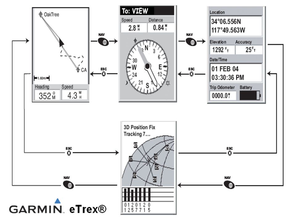
Reading A GPS 3 Formats hemisphere degrees, minutes, seconds hemisphere degrees, minutes hemisphere degrees hemisphere degrees, minutes, seconds 33 07 03N 87 07 02 W 33 o 07 03N 87 o 07 02 W hemisphere degrees, minutes 33 07 043N 87 07 02W 33 o 07 043N 87 o 07 02W hemisphere degrees 33 11.735N 87 11.718W 33 11.735 o N 87 11.718 o W

23
Conversions 1035.75 miles between latitude lines 69.05 miles between 1 degree of latitude 1.15 miles between minutes.019 miles between seconds; which equals100 feet and 3.5 inches.

24
However its a Sliding Scale At 38 degrees North latitude one degree of latitude equals approximately 364,000 ft (69 miles), one minute equals 6068 ft (1.15 miles), one-second equals 101 ft. one-degree of longitude equals 288,200 ft (54.6 miles), one minute equals 4800 ft (0.91 mile), and one second equals 80 ft.
, one minute equals 4800 ft (0.91 mile), and one second equals 80 ft..")
25
I Need You To Cosign Cosine Open the calculator in Windows (Start Programs Accessories Calculator) Click on View & Scientific Choose Decimal and Degrees Type in known latitude in the following format 11735 as opposed to 33 11.735) degrees. degrees (33.11735 as opposed to 33 11.735) Click the Cosine Key (cos) Multiply answer by 69 The answer is the miles between longitudes at that latitude
 Click the Cosine Key (cos) Multiply answer by 69 The answer is the miles between longitudes at that latitude.")
26
Lets Get… http://www.healingway.org.uk/reflexology-hands.html

35
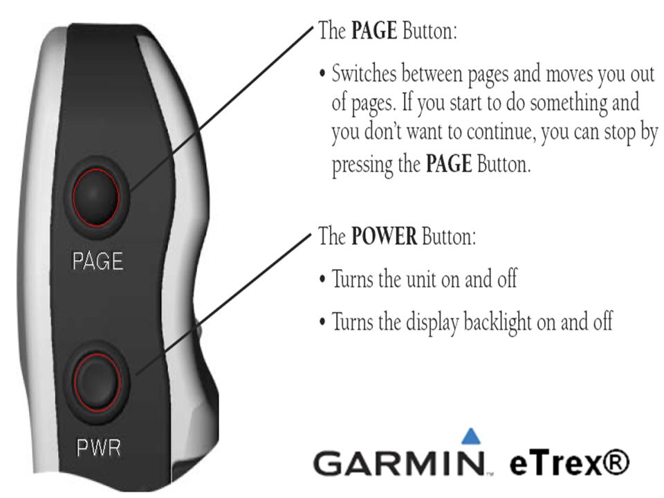
Navigation Button

40
Mark Way point

41
Your Assignment Get in groups of 2 Find a Geocache Mark a waypoint Trade units with another team to find that waypoint Give me back my GPSs

42
Lisa Buck West Blocton High School 4734 Truman Aldrich Parkway West Blocton, AL 35184 (205) 938-9002 BuckL@bibbed.org
")
Similar presentations


>")


