Download presentation
Presentation is loading. Please wait.

1
Relevance of Geospatial Technologies in monitoring Climate Change related disasters in Africa: Special focus on Floods in Dar Es Salaam; Tanzania Shingirirai.S. Mutanga Africa institute of south africa

2
Presentation Outline Impacts of Climate Change Terms and Concepts The problem Background Adaptation Research Objectives The Case of Dar es Salaam Study Focus Flood Risk Mapping Meteorological characteristics Summary of Results Overview of Adaptation Application of Geospatial Technologies Wrapping Up!! Conclusion

3
Background Climate Variability and Change a reality Increasing Tends. Intensity and Frequency. ( ICSU 2012 ) Droughts & Floods: 1.5million affected.( WGA 2004 )
 Droughts & Floods: 1.5million affected.( WGA 2004 ).")
4
Terms & Concepts Climate, Variability, Change and Vulnerability a reality. ST Deviation of Climate Variable from long term mean. LT change in the earth's climate. ( FAO 2007 ) Vulnerability: Degree of susceptibility to extremes; Function of Magnitude. Climate Change Mitigation and Adaptation Adaptive Capacity: Ability to plan, prepare and implement measures. Factors: ( Adger 2006 ) Question: How can we build resilience to disaster risks? Geospatial technologies: Key!!!!!!!! Decision Support System for Disaster Management Support Services.
 Vulnerability: Degree of susceptibility to extremes; Function of Magnitude. Climate Change Mitigation and Adaptation Adaptive Capacity: Ability to plan, prepare and implement measures. Factors: ( Adger 2006 ) Question: How can we build resilience to disaster risks. Geospatial technologies: Key!!!!!!!. Decision Support System for Disaster Management Support Services..")
5
Study Focus In the light of the increasing disasters and impacts of climate change, adaptation is not an option but a necessity!!. The risk of floods remain un-explored and the scope of impending losses un-adequately assessed. Many development plans and policy formations overlook the risk, the impending impact, and coping & mitigation strategies despite the growing concerns of climate change. Objectives: Assess the impacts of floods: Identify the hot spots of population and economic assets. Map Dar es Salaams Exposure and Vulnerability extent to floods. Assess the present adaptive measures in place.

6
STUDY FOCUS Dec :2011

7
The City of Dar es Salaam Located Greater Horn of EA Recurrence of Floods. Hot, with 2 rainy seasons (Oct-Dec & Mar-May) Rainfall : 1000mm Temp: 26 degrees Celsius City: Eastern part of the Tanzanian mainland. Area : 1,350 square kilometres. Population : About 4 Million residents. 70% Informal Settlements. 8% Growth Rate
 Rainfall : 1000mm Temp: 26 degrees Celsius City: Eastern part of the Tanzanian mainland. Area : 1,350 square kilometres. Population : About 4 Million residents. 70% Informal Settlements. 8% Growth Rate.")
8
Demography and Economic Characteristics Demography Pop: 2.5mil Pop Density : 1500pple/square km) Economic Growing GDP. Port : 45% Nations gross I manufacturing 95% International Trade

9
APPLICATIONS OF GEOSPATIAL TECH

10
Rainfall Rainfall for the period 1971-2009 Recurrence of floods: 38 years recorded. Year 2011: killed 11 people. Kebede: 2012

11
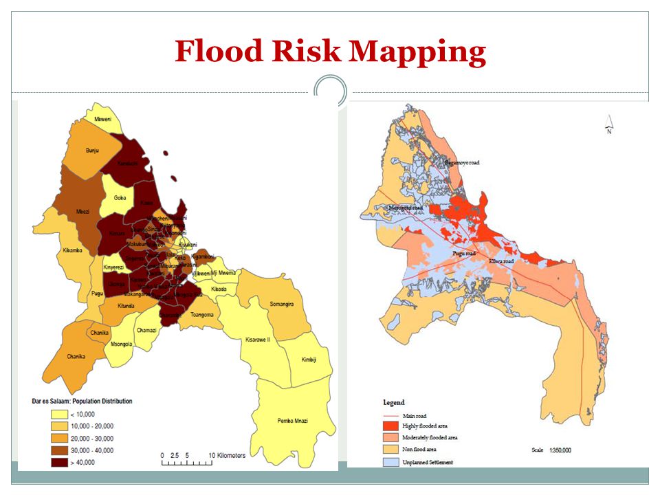
Flood Risk Mapping

13
Summary Projected Statistics 140 000 people located within low elevation zones. Total 8% of people living in below mean sea level=.07% 100 000 people be exposed by 2030. ( Kebede et al 2011 ) 225 ooo people exposed by 2070.
 225 ooo people exposed by")
14
Adaptive Capacity Overview Indicators of Adaptive CapacityLowMediumHighComments Planning for Flood DisastersOften adhoc arrangements in response to floods. Economic Growth Tanzania stands out as a model of sound economic performance with a growth rate of over six percent in 2011 and 2012. Financial Resources Often most projects are donor funded. Slum clearance or squatter upgrading projects in flood prone areas have been abandoned due to financial constrains. Technology Resources & Human Capital lack of access to technology and skills within ministries, departments and agencies are areas of major concern (UN Disaster Management Report). Institutions Policies, strategies, plans and structures needed to support disaster management in Tanzania are in place. However, careful analysis reveals widespread weaknesses in prevention and disaster mitigation strategies, preparedness, emergency responsive capacity and sustainable recovery options. Population Growth & Increased Vulnerability Projected 85% population living in Dar es salaam exposed to floods. Floods Frequency & SeverityIncreased frequency and the worst since 1957 having been experienced in 2011; Lack of sufficient and good quality observational local climate data, hinder accurate and planning for early warning to floods.
. Institutions Policies, strategies, plans and structures needed to support disaster management in Tanzania are in place. However, careful analysis reveals widespread weaknesses in prevention and disaster mitigation strategies, preparedness, emergency responsive capacity and sustainable recovery options. Population Growth & Increased Vulnerability Projected 85% population living in Dar es salaam exposed to floods. Floods Frequency & SeverityIncreased frequency and the worst since 1957 having been experienced in 2011; Lack of sufficient and good quality observational local climate data, hinder accurate and planning for early warning to floods..")
15
Key Challenges 1.Lack of Capacity 2.Financial Constraints 3.Poor Planning 4.Mushroom of informal Settlements 5.Poor forecasting 6.Lack of public awareness. 7.Overreliance on donor funding

16
Conclusion Climate change is a reality and there is need to deal with its effects such as floods. The development of a comprehensive flood hazard map would be one of the most crucial steps for implementing non-structural remedial measures. Provision of case studies that map community vulnerability areas is key in building resilience to natural disasters such as floods. This study through the use of geospatial technologies aid in draw out implications for adaptation and adaptive policy.

17
Further Analysis/Research Exposed population and Assets. Delineation of Settlements and industries prone to floods. Economic Value of estimated exposed assets. Dual combination of bursting streams and rising sea level impacts. Gaps: Social dimensions, participatory approaches, lack of up to date information.

18
THANK YOU

Similar presentations


>")


