Download presentation
Presentation is loading. Please wait.

1
Folds, Faults & Geologic Maps

2
Rock deformation Deformation is a general term that refers to all changes in the original form and/or size of a rock body

3
Rock deformation Stress – The Cause of Deformation
Geologic forces at work: Plate tectonics Stress = force/area

4
Stress – The Cause of Deformation
Rock deformation Stress – The Cause of Deformation

5
Components of Deformation
Relocation Tilting Changing shape Faulting Folding

6
Rock deformation Strain - change in shape due to deformation Types
Stretching Shortening Shear

7
Rock deformation Types of deformation Elastic Brittle Ductile

8
Rock deformation Elastic deformation
Temporary change in shape or volume from which a material rebounds after the stress is removed

9
Rock deformation Ductile deformation
Permanent but gradual change in shape or volume of a material, caused by flowing or bending

10
Rock deformation Brittle deformation
Permanent change in shape or volume, in which a material breaks or cracks

11
Deformation Factors that influence the strength of a rock Temperature
Pressure Rock type (composition) Rate of deformation Time
 Rate of deformation. Time.")
12
Most crustal deformation occurs along plate margins

13
Rock Deformation Craton: A region of continental crust that has remained tectonically stable for a very long time

14
Rock Deformation Orogen: An elongated region of crust that has been deformed and metamorphosed through a continental collision

15
Continental Accretion
Rock Deformation Orogenesis refers to processes that collectively produce a mountain belt Three mechanisms: Ocean-Ocean and Ocean-Continental Convergence Continental-Continental Convergence Continental Accretion

16
Orogenesis Andean-type mountain building
Oceanic-Continental Subduction Continental volcanic arcs forms

17
Orogenesis Aleutian-type mountain building Oceanic-Oceanic Subduction
Volcanic island arcs forms

18
Orogenesis Continental collisions
Where two plates with continental crust converge Mountains form

19
Orogenesis Continental accretion
Small crustal fragments collide with and accrete to continental margins Accreted crustal blocks are called terranes

20
Distribution of modern day oceanic plateaus and other submerged crustal fragments

21
Folds Rocks bent into a series of waves
Most folds result from compressional forces which shorten and thicken the crust Types of folds Anticline – upfolded, or arched, rock layers Syncline – downfolded rock layers

22
Folds Types of folds Anticlines and synclines can be
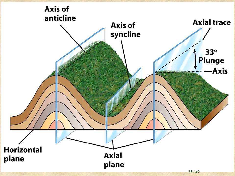
Symmetrical - limbs are mirror images Asymmetrical - limbs are not mirror images Overturned - one limb is tilted beyond the vertical Where folds die out they are said to be plunging

24
A series of anticlines and synclines

25
Plunging folds

26
Outcrop patterns of plunging folds

27
Folds in the Appalachian Mnts, Pennsylvania

28
Folds Dome Basin Circular, or slightly elongated
Upwarped displacement of rocks Oldest rocks in core Circular, or slightly elongated Downwarped displacement of rocks Youngest rocks in core

29
The Black Hills of South Dakota are a large dome

30
The bedrock geology of the Michigan Basin

31
Dome in Flinders Range, South Australia

32
Faults Faults are fractures (breaks) in rocks along which appreciable displacement has taken place
 in rocks along which appreciable displacement has taken place")
33
Concept of hanging wall and footwall along a fault

34
Types of Faults Normal Faults

35
Normal Faults Extensional Tectonics

36
Fault block mountains produced by normal faulting

37
A reverse fault with a shallow angle of dip
Types of Faults Reverse Thrust The block on top of the fault surface moves up and over the block on the bottom A reverse fault with a shallow angle of dip

38
Types of Faults Strike-slip faults
Dominant displacement is horizontal and parallel to the trend, or strike Right, Left and Transform fault

40
Geologic Maps Shows the locations, kinds, & orientation of rock units & structural features (faults & folds)
")
41
Geologic Mapping Strike Dip
The compass orientation of the line of intersection between a horizontal plane and a planar feature (e.g. rock layer or fault) Dip The angle between the tilted surface and a horizontal plane
 Dip. The angle between the tilted surface and a horizontal plane.")
42
Geologic Mapping

43
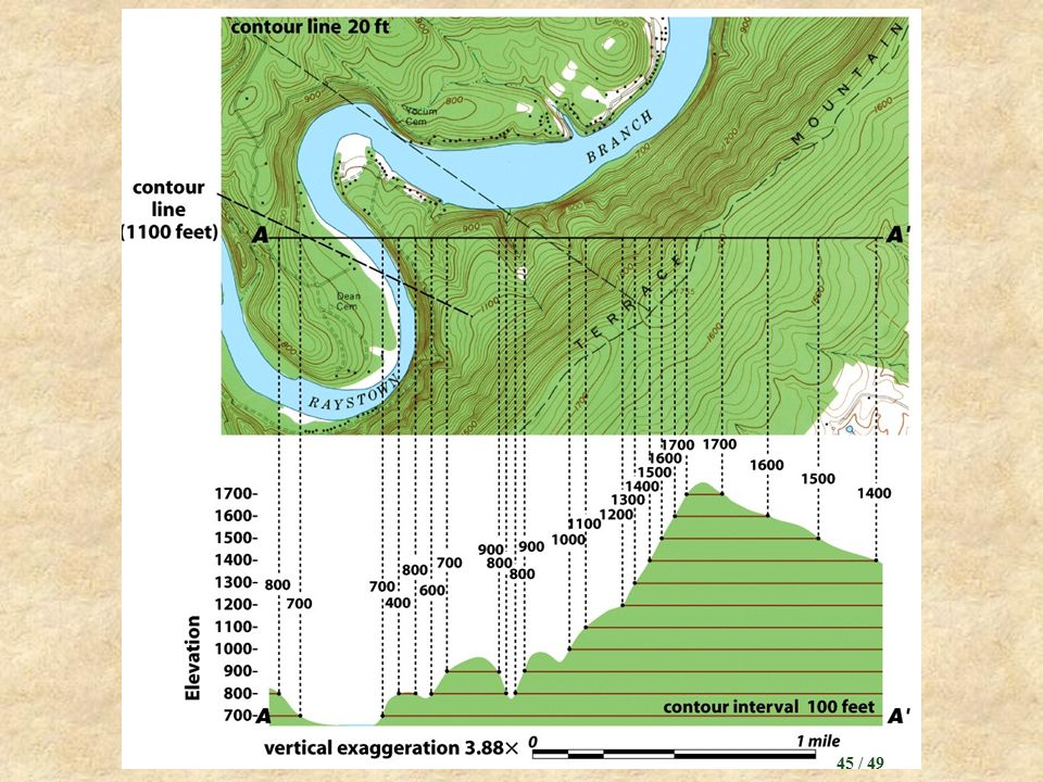
Geologic Mapping Making and interpreting geologic maps
Topographic maps… Show the shape of a ground surface, as well as the location and elevation of surface features, usually by means of contour lines

44
Geologic Maps

46
~ End ~

Similar presentations