Download presentation
Presentation is loading. Please wait.

2
Reading assignments for chapter 6 Pages –337-435 –436-438 –439-449 –451-465

3
QuickBird Commercial remote sensing system developed and operated by Digital Globe QuickBird 1 was launched on 20 Nov, 2000, but failed to reach orbit QuickBird 2 was Launched on 18 October 2001

4
Quickbird-2 orbit Type: Sun-Synchronous Altitude: 450 Km Inclination: 98 degree Period: 93.4 minute Off-Nadir Revisit: 1 to 3.5 days

5
QuickBird Features Panchromatic and multispectral images High spatial resolution: up to 61 cm panchromatic images; 2.44 m multispectral images at nadir Buildings, cars, and even large individual trees can be recognized using QuickBird Nominal swath width: 16.5 km at nadir Radiometric response: 11bits (2048 grey levels)
")
6
Sensor Characteristics (Quickbird) Spectral bandWavelength ( m) Resolution (at nadir) Resolution (at 30 deg. off nadir) 1 (blue)0.45-0.522.5 m2.9 m 2 (green)0.52-0.602.5 m2.9 m 3 (red)0.63-0.692.5 m2.9 m 4 (NIR)0.76-0.892.5 m2.9 m Panchromatic0.45-0.900.61 m0.73 m
 1 (blue) m2.9 m 2 (green) m2.9 m 3 (red) m2.9 m 4 (NIR) m2.9 m Panchromatic m0.73 m.")
7
QuickBird Panchromatic Image QuickBird Panchromatic image with 61 cm resolution, taken over Fairfax, Virginia, USA.

8
QuickBird Colour Image QuickBird natural colour image with 2.44 m resolution, taken over Fairfax, Virginia, USA

9
Quickbird

10
Ocean monitoring satellites Nimbus-7 (1978) –Carried the Coastal Zone Color Scanner (CZCS) to measure the color and temperature of the coastal zones of the oceans (visible, near IR and thermal region bands) –1566 km width –825 m resolution at nadir –Ceased operation in December 1986 – sun-synchronous, near-polar, 955-km orbit, repeat circle 6 days
 –Carried the Coastal Zone Color Scanner (CZCS) to measure the color and temperature of the coastal zones of the oceans (visible, near IR and thermal region bands) –1566 km width –825 m resolution at nadir –Ceased operation in December 1986 – sun-synchronous, near-polar, 955-km orbit, repeat circle 6 days")
11
Nimbus-7

12
Ocean Monitoring Satellites Marine Observations Satellite (MOS-1) in 1987 and MOS-1b in 1990 by Japan employed: –A 4-channel Multispectral Electronic Self-Scanning Radiometer (MESSR) –A 4-channel Visible and Thermal Infrared Radiometer (VTIR) –A 2-channel Microwave Scanning Radiometer (MSR)
 in 1987 and MOS-1b in 1990 by Japan employed: –A 4-channel Multispectral Electronic Self-Scanning Radiometer (MESSR) –A 4-channel Visible and Thermal Infrared Radiometer (VTIR) –A 2-channel Microwave Scanning Radiometer (MSR)")
13
Ocean Monitoring Satellites MOS-1 and MOS-1b characteristics: –Orbit height: 909 km and revisit period: 17 days –Multispectral Electronic Self-Scanning Radiometer (MESSR) spectral bands similar to Landsat MSS (ground resolution 50m)
 spectral bands similar to Landsat MSS (ground resolution 50m)")
14
Spectral bands of CZCS The first four bands of the CZCS sensor are very narrow. They were optimized to allow detailed discrimination of differences in water reflectance due to phytoplankton concentrations and other suspended particulates in the water.

15
Nimbus-7 CZCS images Black Sea phytoplankton pigments concentration

16
Hyperspectral Satellite systems Earth Orbiter mission (EO-1) –Hyperion The Hyperion provides 220 spectral bands of data over the 0.4-2.5 m band width 10 nm 30 m spatial resolution This instrument can cover a 7.5 by 100 km land area in each image 2000 to present Naval EarthMap Observer (NEMO) satellite program – Coastal Ocean Imaging Spectrometer (COIS) This instrument acquires data in 210 spectral bands over the range of 0.2- 2.5 m The system supports data acquisition at resolutions of either 30 or 60 m over a 30 km swath width. A 5-m resolution Panchromatic Imaging Camera (PIC) is flown in combination with the COIS instrument and covers the same 30-km swath. Australian Resource Information and Environmental Satellite (ARIES) – Its nominal specifications include a hyperspectral imager with up to 105 spectral bands located between 0.4 and 2.5 m – 30 m spatial resolution, plus 10 m panchromatic imager – 15-km swath
 is flown in combination with the COIS instrument and covers the same 30-km swath. Australian Resource Information and Environmental Satellite (ARIES) – Its nominal specifications include a hyperspectral imager with up to 105 spectral bands located between 0.4 and 2.5 m – 30 m spatial resolution, plus 10 m panchromatic imager – 15-km swath.")
17
Moderate Resolution Systems Examples IRS (Indian Remote Sensing), several efforts and programs, best resolution 5.8 m (panchromatic sensor) RESURS (Soviet Union / Russia), 4 efforts, best resolution 33/29 m (multi) ADEOS (Japan), best resolution 8 m JERS-1 (Japan), best resolution 18/24 m CBERS (China, Brazil), best resolution 20 m New Millennium Program (NASA JPL), 2 hyperspectral and one multispectral (ALI, comparable to ETM+, best resolution 10 m pan, 30 m multi)
, several efforts and programs, best resolution 5.8 m (panchromatic sensor) RESURS (Soviet Union / Russia), 4 efforts, best resolution 33/29 m (multi) ADEOS (Japan), best resolution 8 m JERS-1 (Japan), best resolution 18/24 m CBERS (China, Brazil), best resolution 20 m New Millennium Program (NASA JPL), 2 hyperspectral and one multispectral (ALI, comparable to ETM+, best resolution 10 m pan, 30 m multi)")
18
Earth Observing System (EOS) EOS is one of the primary components of the Mission to Planet Earth NASA program Currently renamed Earth Science Enterprise Several satellites and sensors
 EOS is one of the primary components of the Mission to Planet Earth NASA program Currently renamed Earth Science Enterprise Several satellites and sensors")
19
EOS Terra The Terra spacecraft was launched December 18, 1999 Instruments included on Terra are: –ASTER: Advanced Spaceborne Thermal Emission and Reflection Radiometer –CERES: Clouds and Earth’s Radiant Energy System –MIRS: Multi-Angle Imaging Spectro-Radiometer –Moderate Resolution Imaging Spectrometer (MODIS, NASA) –MOPITT: Measurements of Pollution in the troposphere
 –MOPITT: Measurements of Pollution in the troposphere")
20
Terra Satellite MODIS ASTER (TIR) ASTER (SWIR) ASTER (VNIR) MISR MOPITT CERES
 ASTER (SWIR) ASTER (VNIR) MISR MOPITT CERES")
21
Moderate Resolution Imaging Spectrometer (MODIS, NASA) It is useful for multiple land and ocean applications, cloud cover, and could properties IFOV: 250 x 250 m VNIR bands ( bands 1 and 2), 500 x 500 m VNIR bands (bands 3-7), 1 x 1 km VNIR/TIR bands (bands 8-36) swath width 2330 km Earth images once every 2 days 1999 to present
 It is useful for multiple land and ocean applications, cloud cover, and could properties IFOV: 250 x 250 m VNIR bands ( bands 1 and 2), 500 x 500 m VNIR bands (bands 3-7), 1 x 1 km VNIR/TIR bands (bands 8-36) swath width 2330 km Earth images once every 2 days 1999 to present")
22
Earth Observing System MODIS instrument (Moderate Resolution Imaging Spectrometer) –Could be viewed as an improved NOAA-AVHRR and Nimbus CZCS –provide two-day repeat global coverage with greater spatial resolution (250, 500, or 1000 m, depending on wavelength) –but also collects data in 36 carefully chosen spectral bands (0.620 – 14.38 m) –12 bit radiometric sensitivity
 –Could be viewed as an improved NOAA-AVHRR and Nimbus CZCS –provide two-day repeat global coverage with greater spatial resolution (250, 500, or 1000 m, depending on wavelength) –but also collects data in 36 carefully chosen spectral bands (0.620 – m) –12 bit radiometric sensitivity")
23
Earth Observing System MODIS also provides: –Improved geometric rectification and radiometric calibration

24
MODIS Image Snow in Afghanistan February 27, 2006 Bands used: 1,4,3

25
MODIS Image Dust Storm Over Southern Asia December 13, 2003

26
Extended Summer Drought will increase frequency and intensity of wildfires MODIS Composite Image October 27, 2003

27
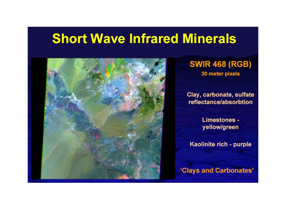
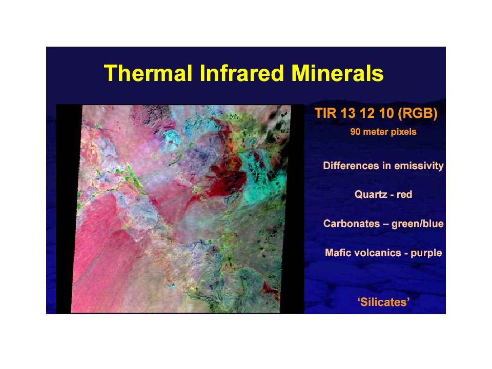
EOS Terra ASTER –The ASTER is a cooperative effort between NASA and Japan’s Ministry of International Trade and Industry –Primary applications include study vegetation, rock types, volcanoes, clouds, and produce DEM’s – 6 SWIR bands: band 6 centered at the clay absorption feature and band 8 at the carbonate absorption feature – 5 TIR bands: bands 10, 11, and 12 at sulfate and silica absorption features

28
ASTER Characteristics Wide Spectral Coverage 3 bands in VNIR (0.52 – 0.86 μm) 6 bands in SWIR (1.6 – 2.43 μm) 5 bands in TIR (8.125 – 11.65 μm) High Spatial Resolution 15m for VNIR bands 30m for SWIR bands 90m for TIR bands Quantization (bits) 8 for VNIR AND SWIR 12 for TIR Swath width 60 km Images are not acquired based on researcher scheduling 1999 to present
 6 bands in SWIR (1.6 – 2.43 μm) 5 bands in TIR (8.125 – μm) High Spatial Resolution 15m for VNIR bands 30m for SWIR bands 90m for TIR bands Quantization (bits) 8 for VNIR AND SWIR 12 for TIR Swath width 60 km Images are not acquired based on researcher scheduling 1999 to present")
29
ASTER consists of 3 subsystems: VNIR, SWIR and TIR

30
ASTER TM Repeat Orbit: 16 d16 d Scene60 km185km Bands: Pan01 15m VIS2 15m3 30m NIR1 30m1 30m SWIR 6 30m 2 30m TIR5 90m1 90m

31
ASTER Images of San Francisco Bay False Color Image (VNIR) Sediment Load (VNIR) Water Temperature (TIR)
 Sediment Load (VNIR) Water Temperature (TIR)")
35
Land Observing Sensors and their Features Weather, Global Coverage Satellites Sensor NamePixelSwathNo. SpectralSpectralTemporal ResolutionWidth, kmBandsCoverageRepeat, days AVHRR1.1km27005VNIR, TIR4*day SPOT Vegetation1.15km22504VNIR, SWIR26 MODIS0.25,0.5,1km233036VNIR, SWIR, TIR2* day Regional Satellites SensormkmbandsSpectralRepeat ASTER15, 30, 906016VNIR, SWIR, TIR16 Landsat ETM+30, 60, 151858Pan + TM16 SPOT HRV10, 20604Pan, VNIR26 SPOT HRVIR10, 20605SWIR + HRV26 Local Coverage Satellites SensormkmbandsSpectralRepeat Quickbird0.61 Pan, 2.4416.55Pan, VNIR2 to 11 IKONOS1.0 Pan, 411.35Pan, VNIR3

36
Medium and coarse resolution sensors SensorPixel Size, m ‘blue’ nm ‘green’ nm ‘red’ nm ‘NIR’ nm ‘SWIR’ m ‘Thermal’ m SPOT- VEGETATION Swath 2250 km 1150430-470610-680780-8901.58-1.75 NOAA- AVHRR Swath 2700 km 1100570-700710-9803.5-3.93 10.3-11.3 11.5-12.5 MODIS (Terra, Aqua) Swath 2330 km 250 500 1000 459-479 405-420 438-448 483-493 545-565 526-536 546-556 620-670 662-672 673-683 841-876 743-753 862-877 890-920 915-965 931-941 1.23-1.25 1.628-1.652 2.105-2.155 1.360-1.3903.66-3.84 3.929-3.989 4.02-4.08 4.433-4.498 4.482-4.549 6.535-6.895 7.175-7.475 8.400-8.700 9.580-9.880 10.78-11.28 11.77-12.27 13.185-13.485 13.485-13.785 13.785-14.085 14.085-14.385
 Swath 2330 km")
37
Medium and coarse resolution sensors Ikonos Swath 13 km 4 1 (pan) 450-520520-600630-690760-900 QuickBird Swath 16.5 km 2.44 0.61 (pan) 450-520520-600630-690760-900 SensorPixel Size, m‘blue’ nm ‘green’ nm ‘red’ nm ‘NIR’ nm ‘SWIR’ m ‘Thermal’ m
 QuickBird Swath 16.5 km (pan) SensorPixel Size, m‘blue’ nm ‘green’ nm ‘red’ nm ‘NIR’ nm ‘SWIR’ m ‘Thermal’ m")
Similar presentations


 M. Fujita, T. Tachikawa, M. Kato, H. Tsu ( ERSDAC, Japan), M.J. Abrams, L. Maldonado.>")


 and Landsat Thematic Mapper (TM) Sensor System Characteristics.>")


-Polar Orbiting Environmental Satellite (POES) Orbital characteristics.>")
