Download presentation
Presentation is loading. Please wait.

1
Maps

2
Latitude and Longitude
Objectives: To know the difference between latitude and longitude To learn how to plot latitude and longitude coordinates

3
Latitude and Longitude
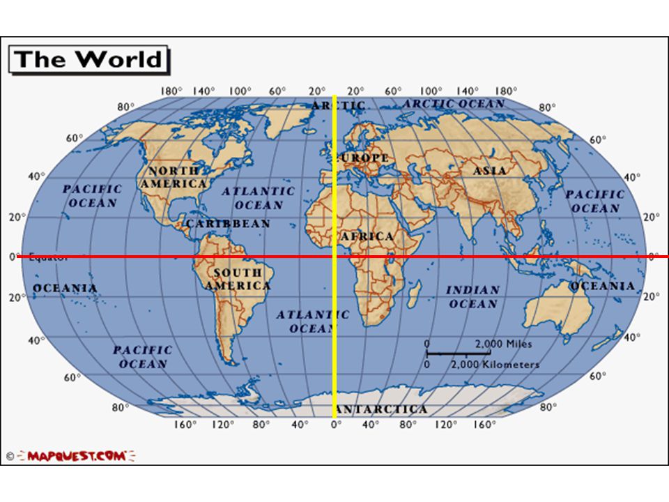
The earth is divided into lots of lines called latitude & longitude Latitude Latitude

4
Latitude Lines Latitude lines run east and west.
The lines run parallel to each other and measure distances in degrees. The equator is at 0 degrees Latitude Equator Latitude

5
Equator The equator is at 0 degrees latitude
All latitude lines run parallel to the equator either north or south

6
What are latitude lines?
Lines that run _____to west and are parallel to the equator The equator is at 0° Answer Bank North South East west Latitude Latitude

7
Longitude Lines Longitude lines run north and south.
Prime Meridian Longitude lines run north and south. The lines also run parallel to each other and measure distances in degrees. The prime meridian is at 0 degrees Longitude Longitude

8
Prime Meridian The prime meridian is 0 degrees longitude. This imaginary line runs through the United Kingdom, France, Spain, western Africa, and Antarctica. All longitude lines run parallel to the prime meridian

9
What are Longitude lines?
Lines that run North to _____parallel to the prime meridian The prime meridian is at 0° Longitude Longitude Answer Bank North South East west

11
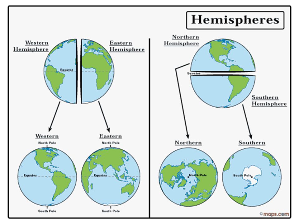
Hemispheres By using the equator and prime meridian, we can divide the world into four hemispheres, north, south, east, and west.

13
NW NE N W E S SE SW

14
What are Hemispheres? _____ division of the earth that are divided up into the northwest, northeast, southwest, and southeast sections Answer Bank North South East 4

15
What is the latitude & longitude for: -Sacramento California
-Darwin Australia Lat= 40 degrees North Long = 120 degrees West Lat= 20 degrees South Long = 140 degrees East

16
What is the latitude & longitude for:
-Mount Everest -Lima Peru Lat= 30 degrees North Long = 80 degrees East Lat= 10 degrees South Long = 70 degrees West

17
Summarize: What is the difference between latitude and longitude?
What are the 4 hemispheres of the earth? The__________ runs 0 degrees east to west The__________ runs 0 degrees north to south

18
Topic: Topographic maps
Objectives: To learn about topographic maps To learn mapping basics, such as contour lines and intervals To learn contour rules

19
Topography is the shape of the land
Topographic Maps Topography is the shape of the land A topographic map shows the shape of the Earth’s surface by using contour lines.

20
What is a Topographic Map?
Topography is the shape of the land A topographic map shows the _____ of the Earth’s surface by using contour lines. Answer Bank Upstream Equal Side Shape Circles steep

21
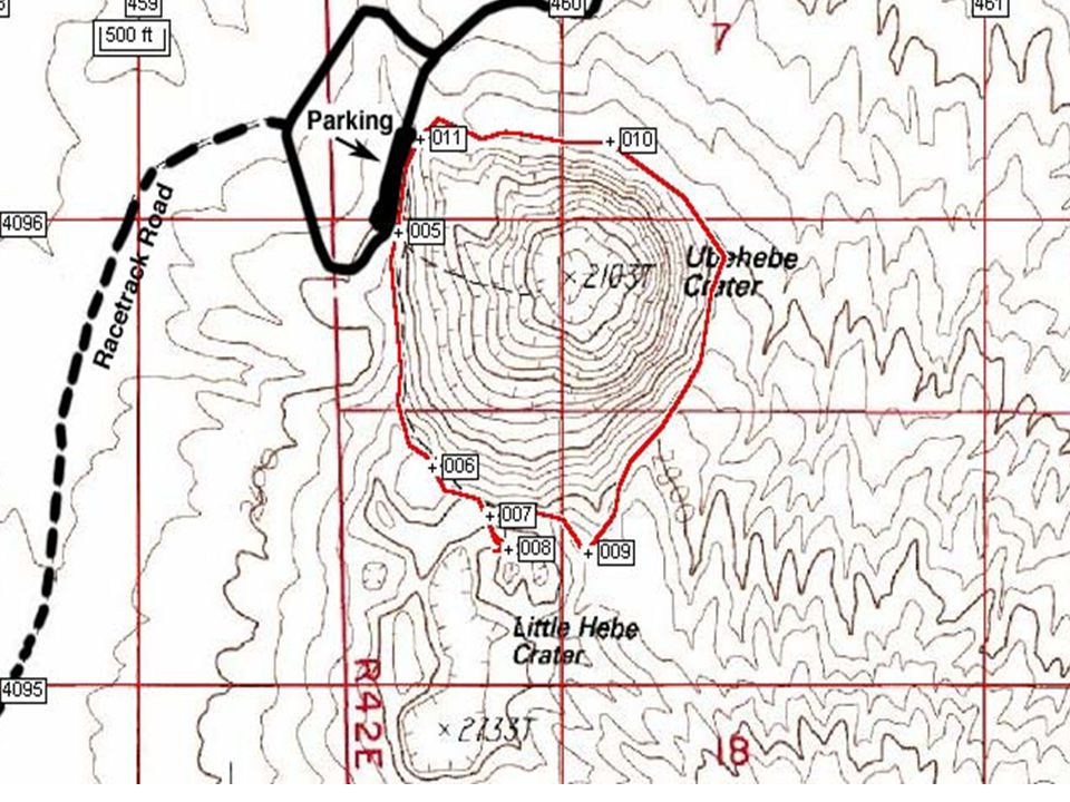
Contour Lines Contour Lines are imaginary lines that join points of equal elevation above or below sea level. Every Where on the contour line, The elevation is 400 meters

22
What are Contour Lines? Contour Lines are imaginary lines that join points of _____elevation above or below sea level. Answer Bank Upstream Equal Side Shape Circles steep Every Where on the contour line, The elevation is 400 meters

23
Contour Interval The Contour Interval is the difference in elevation between one contour line and the next. Can you figure out the contour interval on the map to the right?

24
What are the elevations indicated by the letters on the map below?
Contour interval 20 meters (m) 20ft Contour Interval = A = B = C = D = 700ft 740ft 770ft 820ft
 20ft. Contour Interval = A = B = C = D = 700ft. 740ft. 770ft. 820ft.")
25
What is the Contour Interval?
The Contour Interval is the difference in ____ between one contour line and the next. Contour Lines Answer Bank Upstream elevation Side Shape Circles steep Contour Interval = 20 meters 100 meters between 800 & 700 5 contour lines 100/5= contour interval Contour interval = 20 meters

26
PROFILE A profile shows a side view from a flat topographic map. A B

27
What is a PROFILE? A ____ view from a flat topographic map. Answer
Bank Upstream Equal Side Shape Circles steep

28
Contour Mapping Rules In order to make a contour map, there are rules we first must understand. These rules will help us determine the topography and shape of the land

29
Contour Mapping Rules 1. Hills and depressions are represented by circles. Hachure Lines are used to show depressions. Hill Depression

31
Contour Mapping Rules 2. Contour lines never cross.

32
Contour Mapping Rules 3. When contour lines meet a river or a stream they form a “V” that points upstream.

33
“V’s” Point upstream

34
Contour Mapping Rules A B A B
4. Contour Lines close together = steep slopes Contour Lines far apart = flat gentle slopes A B A B

35
Changing from top to side
The farther apart the lines, the flatter the terrain The closer the lines, the steeper the terrain

36
What are the contour map rules?
Hills and depressions are represented by _____. Hachure Lines show depressions Contour lines never cross!!!! Contour lines that cross a river form a “V” that points_____ Contour Lines close together = ____ slopes Contour Lines far apart = flat areas Answer Bank Upstream Equal Side Shape Circles steep

37
Summarize: Contour ____ is the difference in elevation between one contour line and the next. Hills are represented by _____ Contour Lines close together = ___slopes Contour Lines farther apart = ___ areas Contour lines make “V’s” that point ______ when they cross a river Answer Bank Circles Flat upstream Interval steep lines

38
Topic: California Hazard Maps
Objectives: I will know the unique geologic provinces of California I will be able to analyze and interpret California hazard maps I will be able to identify which areas of California are prone to earthquakes, floods, tsunamis, and volcanic eruptions

39
California Provinces A province is a space or piece of land that has similar geologic features California is subdivided into 11 unique provinces

40
California Provinces The 11 provinces are: Coast Range
Klamath Mountains Transverse Range Cascade Range Great Valley Peninsular Range Modoc Plateau Sierra Nevada Basin and Range Mojave Desert Colorado Desert

41
What are the 11 California Provinces?
Answer Bank Southern Mountainous Nevada Flooding Valley geothermal Coast Range Klamath Mountains Transverse Range Cascade Range Great _____ Peninsular Range Modoc Plateau Sierra _____ Basin and Range Mojave Desert Colorado Desert

42
Earthquakes San Andreas Fault
Earthquakes happen mostly in areas active faulting The San Andreas Fault is the plate Boundary between the Pacific plate and North American Plate San Andreas Fault

43
Earthquakes San Andreas Fault
The map to the left shows earthquake activity within the last week The second map is an earthquake hazard map The coast province is the most affected by earthquakes San Andreas Fault

44
Where do Earthquakes occur?
Near the San Andreas Fault Provinces affected by earthquakes include the coast range, transverse, and peninsular range

45
Tsunamis Any coastal province in California can be hit by tsunamis
This includes the coast range, Transverse range and peninsular range

46
Where do Tsunamis Occur?
Answer Bank Southern Mountainous coast Nevada Flooding Valley geothermal In provinces along the California_____ Ex: coast range, Transverse range and peninsular range

47
Landslides Landslides occur in mountainous provinces where loose soil or rock slides downhill Landslides can also be triggered by excessive rainfall

48
Floods Foods occur in low lying provinces
These are areas with flat land, rivers and rainfall (areas in green) The great valley is subjected to floods
 The great valley is subjected to floods.")
49
Where do Floods & Landslides Occur?
Floods occur in low lying flat provinces such as the great valley Because we live in the great valley our greatest threat is_____ Landslides occur in _______ (high elevation) provinces such as the coast range provinces Answer Bank Southern Mountainous Nevada Flooding Valley geothermal
 provinces such as the coast range provinces. Answer. Bank. Southern. Mountainous. Nevada. Flooding. Valley. geothermal.")
50
Volcanoes Active Volcanoes
Such as Lassen and Shasta occur in the Cascade range Province These volcanoes form by two converging plates

51
Volcanoes Geothermal energy is clean energy we get from heat inside the earth It is renewable (doesn’t run out) and doesn’t pollute our air & water
 and doesn’t pollute our air & water.")
52
Where do Volcanoes Occur?
In the cascade provinces which was offset from a converging plate boundary ______ energy is a clean renewable energy source we use Answer Bank Southern Mountainous Nevada Flooding Valley geothermal

53
Rainfall Northern California provinces receives much more rain fall
In fact, most of southern California provinces are classified as deserts!!!

54
Rainfall Most of California’s population lives in Southern California
With little rivers or little rainfall, where do the people get their water from? Answer: California Aqueduct system

55
Rainfall The aqueduct system delivers water from northern California provinces to southern California provinces

56
What part of California receives the most rain fall?
Answer Bank Southern Mountainous Nevada Flooding Valley geothermal Northern California As a result, the aqueduct system transfers water to ______ California

57
Summarize: _______ energy is clean renewable energy from volcanoes that does not pollute The purpose of the ______ system is to transfer water to dry southern California cities We live in the great valley province which is prone to _________ Answer Bank Aqueduct floods geothermal

Similar presentations


 W (Want to know) L (What I learned) Warm up- take out a piece of paper and do the “K” and the “W” for the above topic.>")


