Download presentation
Presentation is loading. Please wait.

1
Everything You Wanted to Know About GPS and WAAS

2
Everything You Wanted to Know About GPS and WAAS (Unless you are an engineer!)
")
3
Agenda Basics of GPS WAAS What’s next? Q&A
Recent change to AIM, AC RNAV, RNP or not? WAAS How it works What can it do for me? Approaches (LPV, LNAV/VNAV) SIDs, STARs, Q-Routes, and T-Routes What’s next? Performance-based National Airspace System Q&A
 SIDs, STARs, Q-Routes, and T-Routes. What’s next Performance-based National Airspace System. Q&A.")
4
The Usual Caveats Valid for navigation in the US National Airspace System Does not invalidate or change ANYTHING required by your POI or in your OpSpec Does not supersede ANYTHING in your POH/AFM Some equipment requires specific operational mitigations

5
FAA Mission Navigation Services goal
Provide the safest, most efficient aerospace system in the world Navigation Services goal Provide safe, cost effective navigation services to meet operational needs of the aviation customer

6
The National Airspace System (NAS)
18,000 airports 750 control facilities 4,000 commercial flights per day 100,000 commercial passengers per day Plus thousands of Part 91 operations every day

7
GPS Basics Nominal 24 GPS satellites in low earth orbit
Each satellite transmits data message Airborne receiver processes message to determine position/velocity/time Navigation function; either in FMS or in GPS (stand-alone) Linear, not angular
 Linear, not angular.")
8
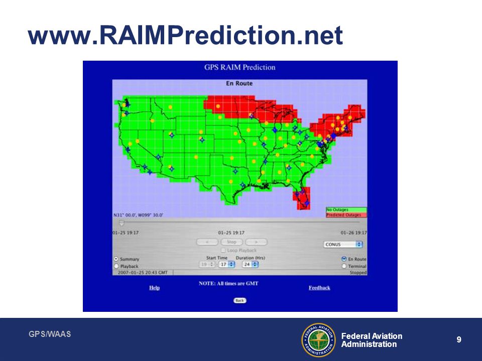
Receiver Autonomous Integrity Monitoring (RAIM)
Calculates your position vs. satellites to determine if sufficient for navigation Considers known satellite outages RAIM check for destination and alternate Required for GPS

10
NOTAMS GPS outages Satellite outages Usually military
Used in RAIM prediction

11
With Approved GPS, I can:
File RNAV Fly an LNAV approach Fly an RNP/RNAV approach Fly a GPS approach …but I can’t file a GPS alternate

12
An RNAV Aircraft Can Substitute RNAV for VOR, ADF or DME that is out of service Use as alternative means of navigation guidance (no requirement to monitor VOR, etc.) Extracted from AIM, Section 1-2-3, “Use of RNAV Equipment on Conventional Procedures and Routes” Define “Conventional”
 Extracted from AIM, Section 1-2-3, Use of RNAV Equipment on Conventional Procedures and Routes Define Conventional")
13
“Conventional” Is Not RNAV
Older TSOC-129 boxes Lack sufficient database memory May lack ability to provide path guidance (path terminators) Suitable for most operations, but not RNAV/RNP No restrictions on newer units Information on specific units under “Policies and Guidance” at: afs400/afs410
 Suitable for most operations, but not RNAV/RNP. No restrictions on newer units. Information on specific units under Policies and Guidance at: afs400/afs410.")
14
Fly-By and Fly-Over Waypoints

15
Fly-By or Fly-Over – Yes, It Is Important

16
Can I Fly An RNAV Procedure?
Answer is in AC A and online, updated table RNAV Q/T Routes (Terminal) RNAV 1 (ER) RNAV 2 Unit Substitution GNS 430 GNS 530 GNS/CNX 480* Yes No Yes No Yes No Yes *Needs T2 letter of acceptance
 RNAV 1. (ER) RNAV 2. Unit. Substitution. GNS 430. GNS 530. GNS/CNX 480* Yes. No. Yes. No. Yes. No. Yes. *Needs T2 letter of acceptance.")
17
Regardless Of The System, Remember That
“Pilots may not substitute for the navigational aid providing lateral guidance for the final approach.” (AIM, pg 1-2-6)
")
18
Typical Conventional Arrival

19
RNAV Arrival Not a conventional arrival Computer generated waypoints
Mix of fly-over and fly-by

21
WAAS System

22
How WAAS Works

23
WAAS Capabilities Why WAAS? Better than 99.99% availability of system
Enhances en-route navigation performance over GPS alone Enhances non-precision approach capability over GPS alone Allows WAAS equipped users to fly more than 2,891 published LNAV/VNAV procedures to minimums as low as 300 feet Allows WAAS equipped users to fly new LPV procedures Can use GPS for an alternate (LNAV only) Better than 99.99% availability of system 200’ minimum WAAS specific approaches (LPV) 846 LPV approaches published, with 300 new expected each year
 Better than 99.99% availability of system. 200’ minimum WAAS specific approaches (LPV) 846 LPV approaches published, with 300 new expected each year.")
24
With WAAS, I can: Skip the RAIM check! Fly an LNAV/VNAV approach
Fly an LPV approach Use GPS/WAAS entirely …and I can file a GPS alternate But using the LNAV minima line

25
WAAS TSO-C146 “Stand-Alone Airborne Nav Using GPS Augmented by WAAS)
TSO-C145 “Airborne Nav Sensors Using GPS Augmented by WAAS”

26
Instrument Approach Update
NDBs being reduced No new funding for ILS Expansion of LPVs LPV minimums of 200’

27
Localizer Performance with Vertical Guidance (LPV)
Flies like an ILS (but better!) Minimums down to 200’ Why isn’t it a precision approach? What about the pilot test standards?
 Minimums down to 200’ Why isn’t it a precision approach What about the pilot test standards")
28
Charting with LPV Minimum Line
WAAS Channel Number WAAS Approach ID: W24A W: WAAS 24: Runway 24 A: 1st WAAS Approach To Rwy 24 Temperature Restriction Does Not Apply to WAAS Equipment LPV Minimum Line

29
LPV Production Schedule
Currently, 846 LPV approaches Adding 300 per year On the web: gps.faa.gov Click button: GPS/WAAS

30
Standard Instrument Departure

31
Here is what’s coming!

32
Q-Routes

33
T-Routes

34
Coming Soon… LP approaches Helo point in space approaches

35
Why All the Changes? Ask anyone who regularly flies into O’Hare, JFK, ATL Capacity Safety Oh, and money! Seen any new airports under construction? Heard about the anticipated number of VLJs?

36
Nav Aid Cost VOR ILS Neither figure considers cost of real estate
Install = $250,000 20-year life cycle cost = $1,100,000 ILS Install = $1,200,000 20-year life cycle cost = $2,700,000 Neither figure considers cost of real estate

37
Where is this leading? GPS is biggest change to hit aviation since the jet engine! 2007 – decision for drawdown of VORs My personal guess -reduce by 60% over 10 years NDBs are already being divested

38
Performance-Based Navigation
Complete transition by 2025 Consistent with ICAO global vision Operational capability based on GPS and augmentations Enhance safety, capacity, efficiency Reduce costs Streamlined Departures Vector - Free Arrivals All Weather Approaches Efficient, Flexible Routing Performance-based navigation is an end-to-end system of concepts and applications based on performance standards without dependence upon specific technologies or equipment It fully utilizes the capabilities of all aircraft navigation equipment to operate safely and efficiently in conjunction with external signals provided by ground or space based systems FAA approved GPS for operational use over 10 years ago. GPS and its augmentations are key enabling technologies toward implementation of performance based services. They provide this capability in the most cost-effective manner considering the unaffordability of the aging ground based infrastructure GPS does not have the integrity, availability, or accuracy required for precision approaches. This is the main reason FAA has spent over $1B delivering WAAS service and $150M in the development of LAAS. FAA continues to provide support to DoD to ensure the long-term interests of civil & military aviation are addressed. FAA participates on the acquisition team for the GPS-III Program as evaluators and technical advisors The FAA continues to support development of ground-based augmentation (GBAS) using the Local Area Augmentation System (LAAS). The LAAS program continues to work with DoD’s joint precision approach and landing system (JPALS) program to ensure system interoperability and sharing of lessons learned.
 using the Local Area Augmentation System (LAAS). The LAAS program continues to work with DoD’s joint precision approach and landing system (JPALS) program to ensure system interoperability and sharing of lessons learned.")
39
Required Navigational Performance (RNP)
Major change in technical approach – not sensor specific Complete “system” will be RNP certified Aircraft, nav system, autopilot to provide containment and alerting RNP 2 miles en route, 1 mile terminal, 0.3 for approach

40
RNP 0.3 DME/DME NA

41
Larry’s Forecast Satellite-based navigation
More takeoff-direct routing ILS-like accuracy en route throughout the NAS Skeleton framework of VORs as mitigation for possible GPS jamming/obstruction Until we work out a jam-proof system

42
In The Future, You Will: Have to intimately understand the workings of your GPS receiver (to fly IFR) Incredibly capable, but it’s a computer! Spend more time as a “systems operator” You will either love it, or hate it, but it’s here to stay!

43
Three Major FAA Planning Documents
Operational Evolution Plan Roadmap for Performance Based Navigation Next Generation Air Transport System

44
The Next Generation Air Transportation System (NextGen) Plan Defines A System That Can Meet Demands For The 21st Century Trajectory-Based Operations Performance-Based Operations and Services Precision Navigation Weather Integration Network-Centric Information Sharing Surveillance Services Equivalent Visual Operations Super Density Operations Layered, Adaptive Security Capabilities The 108th Congress passed Vision 100 – Century of Aviation Reauthorization Act (PL ). This created a unique coalition of public and private partnerships (Joint Program Development Office (JPDO)). The JPDO is the organization responsible for the development of NextGen NextGen is based on nine core capabilities. Two capabilities that are important to this group are Precision Navigation (GPS and augmentations) and Surveillance Services (ADS-B) The JPDO is evaluating plans to modernize GPS to ensure there is consistency with NextGen. The FAA has worked collaboratively with DoD to define the aviation needs for GPS-III. It is understood that any additional requirements that are unique to the civil community beyond the current baseline will be funded by the civil community. L5 is included in the current baseline.
. This created a unique coalition of public and private partnerships (Joint Program Development Office (JPDO)). The JPDO is the organization responsible for the development of NextGen. NextGen is based on nine core capabilities. Two capabilities that are important to this group are Precision Navigation (GPS and augmentations) and Surveillance Services (ADS-B) The JPDO is evaluating plans to modernize GPS to ensure there is consistency with NextGen. The FAA has worked collaboratively with DoD to define the aviation needs for GPS-III. It is understood that any additional requirements that are unique to the civil community beyond the current baseline will be funded by the civil community. L5 is included in the current baseline.")
45
Navigation Evolution Customer Council (NECC)
Council made up of government and industry members Created by Director of Navigation Services to: Implement the navigation evolution roadmap Adjudication of roadmap comments Develop roadmap updates Liaison between policy-makers and the aviation community

46
Contact me at: (202)
")
47
GPS Inflight Problem Solving
YES NO Does the Damn Thing Work? YES Don't Mess with It? You Idiot!!! Should You Mess with It? NO NO Does Anyone Else Know How to Use It? Hide It? YES You Poor Idiot!!! YES Will You Catch Hell? NO NO Can You Blame Someone Else? Trash It? YES NO PROBLEM

Similar presentations