Download presentation
Presentation is loading. Please wait.

1
NASA GRIP 2010 Brief status report Ed Zipser, Univ. of Utah, Salt Lake City, UT on behalf of the GRIP Science Team

2
What did we do during hurricane season 2010? NSF/NCAR PREDICT (PRE-Depression Investigation of Cloud Systems of the Tropics) NASA GRIP (Genesis and Rapid Intensification Processes) NOAA IFEX (Intensity Forecasting Experiment) GOALS: Remarkably Similar…..Not a coincidence!
 NASA GRIP (Genesis and Rapid Intensification Processes) NOAA IFEX (Intensity Forecasting Experiment) GOALS: Remarkably Similar…..Not a coincidence!.")
3
Mission and Science Overview: Summary of GRIP Science Objectives Genesis: Distinguish the role of the larger-scale environment vs. meso-convective processes near the putative developing center. Rapid Intensification: Relative role of environmental vs. inner core processes? Is RI predictable? Test-bed: Evaluate candidate technologies for remote sensing from aircraft and from satellites. Wind lidar, high frequency passive microwave, dual-frequency radars, Global Hawk itself.

4
Scientific Accomplishments Tropical cyclone genesis Tropical Storm Gaston—null case for development Hurricane Karl—unprecedented multiday coverage from first detection through genesis Rapid Intensification Hurricane Earl—documentation of rapid intensification as well as weakening of a large Category 5 storm Hurricane Karl—observations of rapid intensification from storm stage to Category 3 and landfall

5
Technical Accomplishments In Hurricane Earl First Global Hawk flight over a hurricane In Hurricane Karl 20 crossings of eye of Hurricane Karl by Global Hawk Close flight coordination of Global Hawk, DC- 8, WB-57, NOAA G-IV & P-3, NCAR G-V, and AF C-130s

6
Coordinated flight legs through Category 3 Hurricane Karl, Sept 16, 2010

7
Aircraft Hours in GRIP StormGHDC-8WB-57NOAANSFAF Frank15.300NNN Earl24.239.310.9YYY Gaston014.50NYN Karl48.540.217.5YYY Matthew25.117.80YYY Other Sci012.20NA Transit/test flights8.614.90NA TOTAL121.7138.928.4

8
P-3 WB-57 DC-8

9
PREDICT planning meeting, Nov 2009 at HRD, together with IFEX and GRIP people

10
GRIP Conference Room, Fort Lauderdale Airport (between Customs and Homeland Security)
")
11
PREDICT conference room, at hotel, St. Croix

12
All flights into Earl during rapid intensification, 29-31 August 2010

13
Hurricane Earl Flights August 29-30 August 29 August 30 St. Croix

14
All flights into Hurricane Earl, 1-3 September 2010

15
First Global Hawk flight over a hurricane eye (Earl, Sept 2, 2010)
")
16
HAMSR @ Earl, 9/2/2010, 1815-1905 UTC 10 km 7 km 5 km 3 km Nadir (0-15 km altitude) Reflectivity (experimental) Cloud liquid water Precipitable water Temperature Brightness temperatures (All retrievals are preliminary) Up to 10 K warm core anomaly Tb anomaly Ch. 01 Ch. 04 Ch. 09 Ch. 13 Ch. 19 Ch. 25 4-5 cm TPW Up to 2 mm LWC Significant convection & precipitation Courtesy Bjorn Lambrigtsen

17
Gerry Heymsfield Ed Zipser Liz Ritchie Mike Black …a cooperative effort!...

18
This made all the planning worthwhile! Karl 2010: All Flight tracks (almost) Sept 11-17 Courtesy Scott Braun
 Sept Courtesy Scott Braun.")
19
All flights into pre-Karl, 11 – 13 September 2010

20
All flights into pre-Karl and TS Karl, 13 – 14 September 2010

21
All flights into Hurricane Karl, 16 – 17 September 2010

22
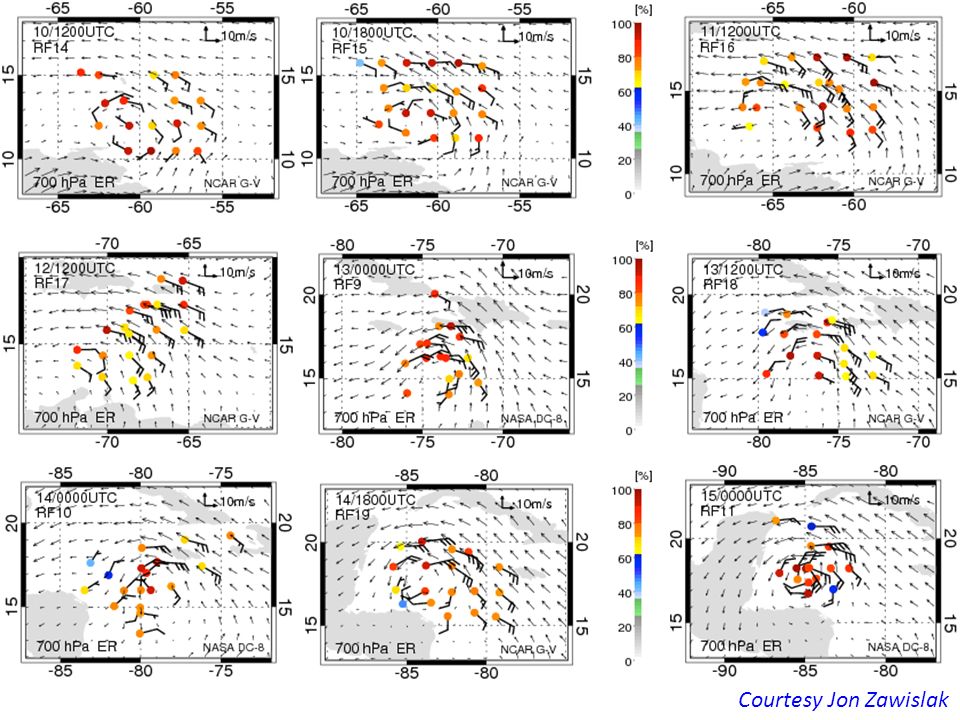
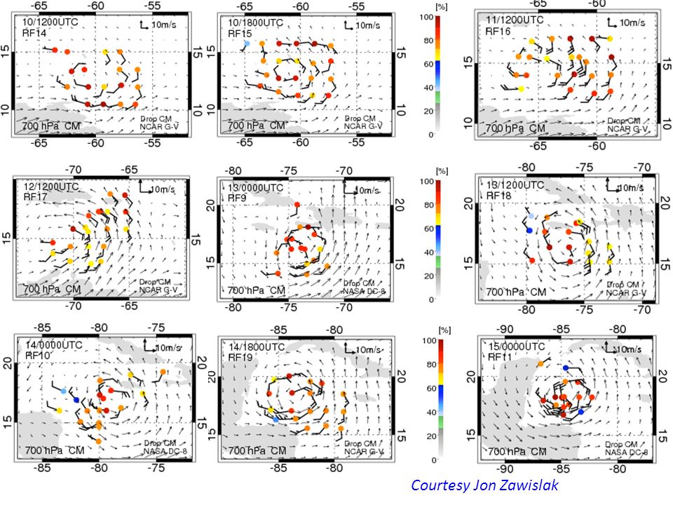
Major Science Questions: Why did Karl take so long to form? What was the time evolution of inner core moistening? Did the convective bursts help? Courtesy Jon Zawislak

23
TD Courtesy Jon Zawislak

26
Major Science Questions: Why did Karl take so long to form? What was the time evolution of inner core moistening? Did the convective bursts help? STAY TUNED: WORK IS JUST GETTING STARTED

27
Example of great data obtained by APR-2 when the DC-8 pilot preferred penetration of an active thunderstorm/MCS complex over Haiti to entering Cuban air space Courtesy Simone Tanelli and APR-2 team from JPL (Cuban air Space here)
")
28
….Frank Marks can bring anyone to his knees….

30
GLOBAL HAWK 2525 3 7 1113 6161 1 2727 HIWRAPDropsondesLIP HAMSR HDVis 5151

31
DC-8 AIRCRAFT WB-57 AIRCRAFT

Similar presentations


 Longtao Wu, Hui Su, and Robert Fovell HS3 Science Meeting 2014 1 May 2014.>")
 During GRIP Lihua Li, Matt Mclinden, Martin Perrine, Lin Tian, Steve Guimond/>")
>")

: 2014 Results Dr. Scott Braun, HS3 PI Paul Newman, HS3 Deputy PI NASA Goddard Space Flight Center IHC, Jacksonville,>")
 Robert Rogers – 2010 HFP Field Program Director 1.>")
 Robert Rogers – 2010 HFP Field Program Director 1.>")
 Shirley Murillo – 2011 HFP Field Program Director 1.>")

 Field Experiment Ramesh Kakar Earth Science Division NASA Headquarters October 13, 2010.>")


 Zhan Li and Zhaoxia Pu.>")
 Timothy L. Miller, NASA/MSFC, P.I. 256.961.7882, Co-investigators: Linwood Jones.>")


