Download presentation
Presentation is loading. Please wait.

1
The Agricultural Landscape
1. Township and Range System 2. Metes and Bounds System 3. Long-Lot System 4. Clustered (aka Nucleated) Settlements 5. Dispersed Settlements
 Settlements. 5. Dispersed Settlements.")
2
The cadastral system: the method of land survey through which land ownership and property lines are defined.

3
What Imprint Does Agriculture Make on the Cultural Landscape?
Cadastral systems Township and Range System (rectangular survey system): Based on a grid system that creates 1-square-mile sections Metes and Bounds Survey: Uses natural features to demarcate irregular parcels of land Long-lot Survey System: Divides land into narrow parcels stretching back from rivers, roads, or canals
: Based on a grid system that creates 1-square-mile sections. Metes and Bounds Survey: Uses natural features to demarcate irregular parcels of land. Long-lot Survey System: Divides land into narrow parcels stretching back from rivers, roads, or canals.")
4
Township and Range System
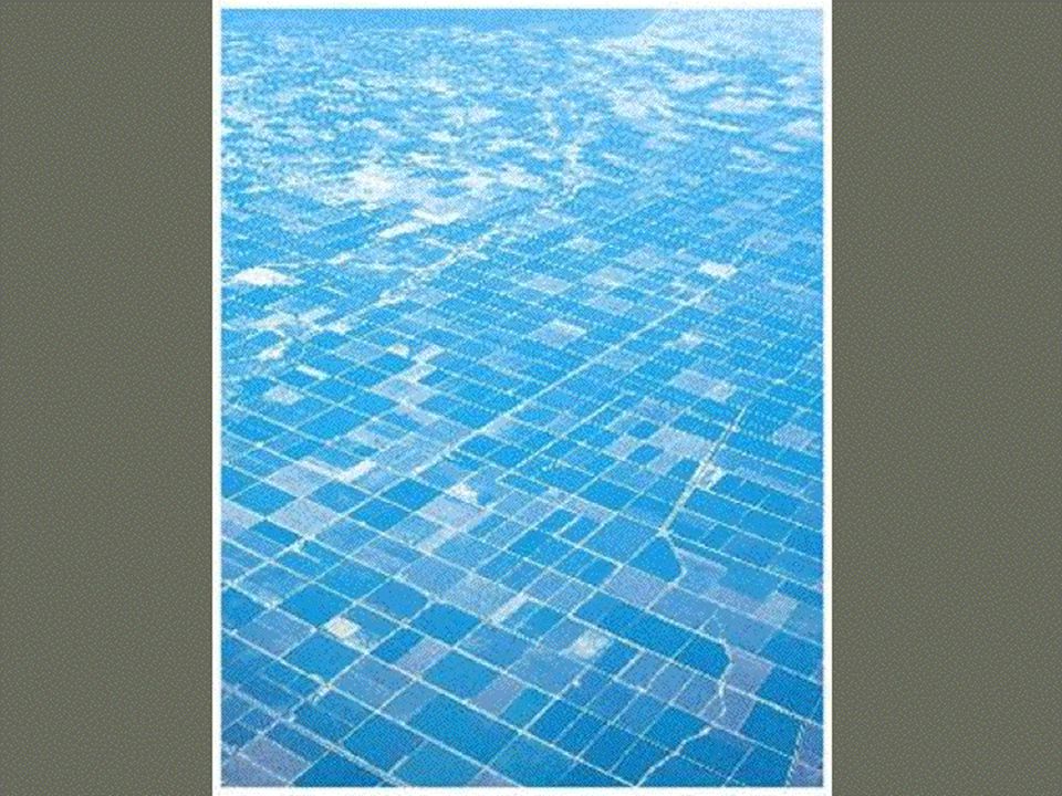
Rectangular survey system designed by Thomas Jefferson after American Revolution as a way of facilitating sale of Western land to settlers. Basic unit in this system is a square mile parcel called a section (640 acres). A six by six mile square of thirty six such sections is called a township. The pattern of farms on the landscape in the interior of the United States reflects the township-and-range system, with farms spaced by sections, half sections, or quarter sections. Drawn without reference to terrain, resulting in regular, uniform parcels of land. Checkerboard pattern in interior rural U.S. Helped create the dispersed rural settlement pattern of the U.S. Midwest and West.
. A six by six mile square of thirty six such sections is called a township. The pattern of farms on the landscape in the interior of the United States reflects the township-and-range system, with farms spaced by sections, half sections, or quarter sections. Drawn without reference to terrain, resulting in regular, uniform parcels of land. Checkerboard pattern in interior rural U.S. Helped create the dispersed rural settlement pattern of the U.S. Midwest and West.")
5
RANGE “R.4.E” would designate the north south line 4 miles East of the designated principal meridian. TOWNSHIP

6
RANGE TOWNSHIP “T.3.S” would designate the east west line 3 miles south of the designated base line, which is based on a designated parallel.

7
RANGE CONFUSION ALERT: “TOWNSHIP” measures the distance north or south of a designated parallel BUT also is the name given to each 6 X 6 mile square. TOWNSHIP Each box on this diagram is a “township” Each township measures 6 miles by 6 miles.

8
Each township is further subdivided into one mile by one mile squares called “sections”
(36 sections per township)
")
10
© 2012 John Wiley & Sons, Inc. All rights reserved.
Figure 11.10 Willamette Valley, Oregon. The township-and-range system has left its imprint on the landscape near Eugene, Oregon, where the grid pattern of six mile by six mile townships and the sections of one square mile each are marked by property lines and roads. © Alexander B. Murphy. © 2012 John Wiley & Sons, Inc. All rights reserved.

13
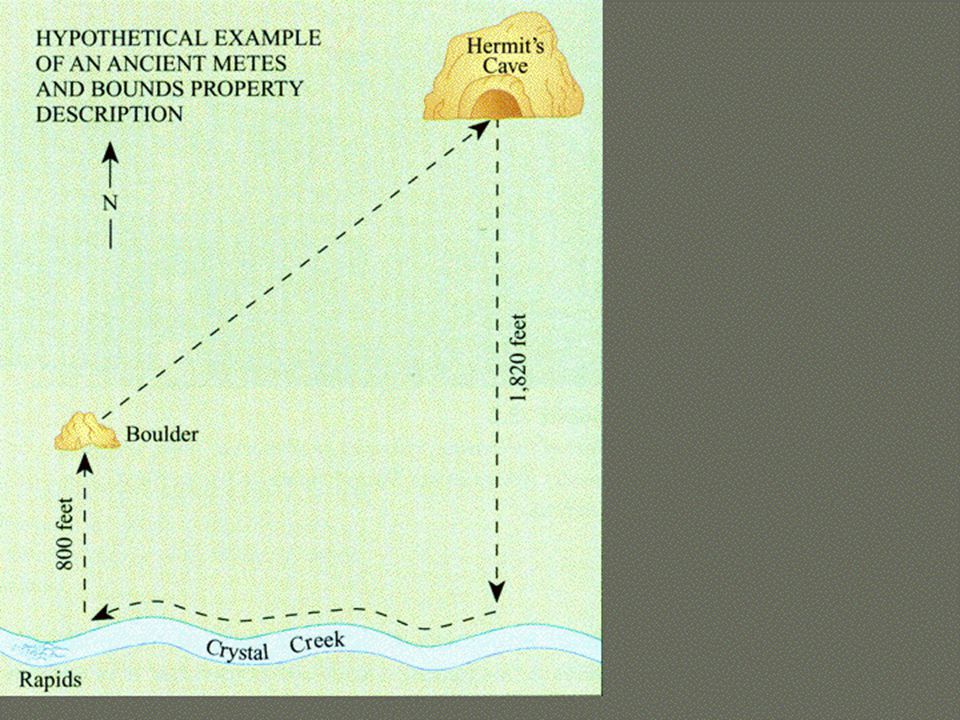
Metes and Bounds System
Uses natural features such as trees or streams to demarcate irregular plots of land. Most prevalent across Eastern Seaboard of U.S. Because of its imprecise nature, it was replaced by the rectangular Township and Range system. Mnemonic device to help remember Metes and Bounds? M easure B y S treams

14
Metes and Bounds "beginning with a corner at the intersection of two stone walls near an apple tree on the north side of Muddy Creek road one mile above the junction of Muddy and Indian Creeks, north for 150 rods to the end of the stone wall bordering the road, then northwest along a line to a large standing rock on the corner of John Smith's place, thence west 150 rods to the corner of a barn near a large oak tree, thence south to Muddy Creek road, thence down the side of the creek road to the starting point."

18
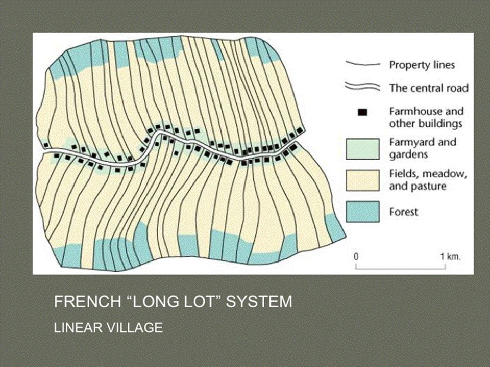
Long-Lot System Divided land into narrow linear parcels stretching back from rivers, roads, or canals so that each farmer would have access to that transportation and/or water resource. French import! Found in areas settled by the French in North America, including the Canadian Maritime regions, Quebec, Louisiana, and Texas.

20
FIGURE 12-12

23
Dominant Land Survey Systems in the U.S.

24
Dominant Land Survey Systems in the U.S.
Township and Range

25
Dominant Land Survey Systems in the U.S.
Township and Range Metes and Bounds

26
Dominant Land Survey Systems in the U.S.
Township and Range Metes and Bounds Long-lot (French diffusion)
")
28
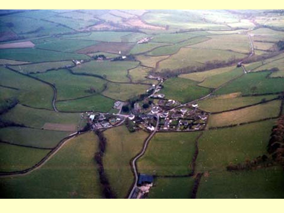
Clustered (aka Nucleated) Settlements
Characterized by a collection of homes, farm buildings, churches, shops in close proximity to each other surrounded by agricultural fields and beyond that woodlands and pastures for common use by all residents. When this type of settlement got too large, new settlements of the same type were established nearby. Because of the many small, scattered fields associated with it, this type of settlement is inefficient and impractical for large scale mechanized agriculture or for feeding large populations. Nevertheless, clustered settlements remain the most prevalent type of rural settlement pattern in agricultural areas around the world.

29
Clustered (aka Nucleated) Settlements, cont.
This type of settlement pattern was dominant in Medieval Europe (N. Germany Rundling as well as walled villages) and is still most prevalent globally (Sub Saharan round villages) Most common in New England before 18th century because settlers there were homogeneous, arrived and were granted land as a group, wanted to reinforce common cultural and religious values, and needed to defend themselves against Indian attacks.
 and is still most prevalent globally (Sub Saharan round villages) Most common in New England before 18th century because settlers there were homogeneous, arrived and were granted land as a group, wanted to reinforce common cultural and religious values, and needed to defend themselves against Indian attacks.")
30
Types of Clustered Settlements

31
FIGURE 12-9

33
FIGURE 12-8

34
FIGURE 12-13

35
FIGURE 12-11

39
39

41
Dispersed Settlements
Individual farmhouses lie quite far apart and the land is intensively cultivated but by machine rather than by hand Ex: United States Midwest. Most common in Mid-Atlantic region of U.S. in 19th century because settlers were heterogeneous, arrived individually, and bought tracts of land individually from speculators. Diffused from Mid-Atlantic to Midwestern U.S.

42
Dispersed Settlements, cont.
Was the most significant impact the Enclosure Movement ( ) on the rural landscape of Great Britain. Associated with agrarian reform (e.g. Enclosure Movement) peace and political stability (no need for protection of village walls), individual initiative (vs. communal agriculture) population resettlement, and rectangular survey system (Township and Range)
 on the rural landscape of Great Britain. Associated with. agrarian reform (e.g. Enclosure Movement) peace and political stability (no need for protection of village walls), individual initiative (vs. communal agriculture) population resettlement, and. rectangular survey system (Township and Range)")
43
43

45
Nucleated vs. Dispersed Settlement Patterns in U.S.
Nucleated (New England) Dispersed (Mid-Atlantic, then diffused into Midwest
 Dispersed (Mid-Atlantic, then diffused into Midwest.")
Similar presentations


 travelling.>")


. The Public Land Survey System (PLSS) was developed by the Continental Congress to replace the common practice of describing.>")


