Download presentation
Presentation is loading. Please wait.

1
The Collaborative Effort Between Stony Brook University and the National Weather Service, Part 1 - Previous Results, Current Status and Future Plans Dr. Brian A. Colle, Matthew Jones Institute for Terrestrial and Planetary Sciences Stony Brook University / SUNY Jeffrey S. Tongue NOAA/NWS Upton, NY

2
l Learn about the benefits and weaknesses of high resolution versus ensemble modeling over the Northeast U.S. l Complete the first detailed multi-season verification over the Eastern U.S (see Colle et al. 2003a,b WAF). l Use the mesoscale model to understand various coastal weather phenomena (landfalling storms, sea breezes, convection). l Use the mesoscale model with other applications (wave modeling, storm surge, energy load forecasting, hydrological modeling). l For classroom education and forecasting. Motivation
. l Use the mesoscale model to understand various coastal weather phenomena (landfalling storms, sea breezes, convection). l Use the mesoscale model with other applications (wave modeling, storm surge, energy load forecasting, hydrological modeling). l For classroom education and forecasting. Motivation.")
3
SUNY-SB Realtime MM5 Domains

4
Floyd (1999) Extratropical Transition 12-km MM5 at 2100 UTC 16 Sept 1999 (21 h) 10 12 18 22 26 oCoC L
 Extratropical Transition 12-km MM5 at 2100 UTC 16 Sept 1999 (21 h) oCoC L")
5
WSR-88D: 21 UTC 9/16/99 1.33 km MM5 (21 h) See Colle (2003, MWR December)
 See Colle (2003, MWR December)")
6
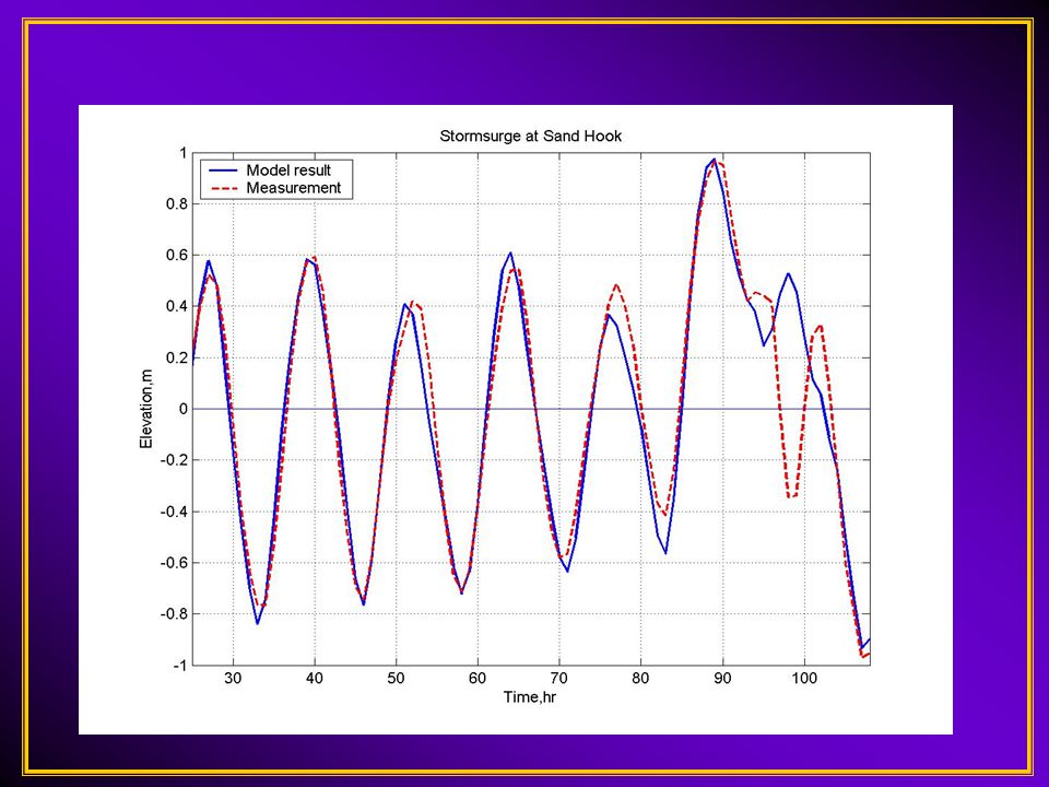
SBU Storm Surge modeling around NYC using POM

7
Storm surge animation of Floyd (1999)
")
9
SBU Wave-modeling using MM5 and WW3 (48 h): Isabel (9/19/00Z) L
: Isabel (9/19/00Z) L")
10
PBL and wave effects on 30 December 2000 Nor-easter (21 UTC, h33) L 990 CTL (MRF) B-T PBLEta PBL MRF/WW3
 L 990 CTL (MRF) B-T PBLEta PBL MRF/WW3")
13
Problem: Sea breezes move inland too fast (At ISP, 50% early, 38% on time, and 16% late) MM5 wind direction mean absolute errors (36 – 12 km)
 MM5 wind direction mean absolute errors (36 – 12 km)")
14
Data sampling over Long Island Sound using the Port Jefferson to Bridgeport Ferry: http://www.stonybrook.edu/soundscience/

15
Observed Winds Model Winds 17:00 GMT June 23rd, 2003 Port Jefferson 17 GMT departure Bridgeport 18:10 GMT arrival N 360 0 = 1 m/s

16
23 JUN 1700 Z Port JeffersonBridgeport Port JeffersonBridgeport

17
48-h mean errors (at 44004) during the 2002-2003 cool season SLP TEMP
 during the cool season SLP TEMP")
18
More negative slp errorsMore positive slp errors NOV JAN DEC FEB

20
24-h Energy Load Forecasts (SW Suffolk Co.) using 12-36 h MM5
 using h MM5")
22
36-km MM5 6-36 h Precip total for physics ensemble of Floyd (1999)
")
23
Development and Evaluation of a 18- Member Real-time Ensemble Forecast System A COMET collaboration between Stony Brook University (SUNY) Brian Colle and Matt Jones NOAA/National Weather Service offices (Upton, NY, Mt Holly, NJ, and Taunton, MA), NE River Forecast Center, and Eastern Region Headquarters
 Brian Colle and Matt Jones NOAA/National Weather Service offices (Upton, NY, Mt Holly, NJ, and Taunton, MA), NE River Forecast Center, and Eastern Region Headquarters")
24
NWS Vision 2005 Goals: “ NWS will move towards adding probabilistic forecast products!” Move from “subjective” model – to –model comparison to the use of more objective ensemble prediction systems American Meteorological Society (AMS) Statement: “The AMS endorses probability forecasts and recommends their use be substantially increased.” “Would allow user (not forecaster!) to make decisions based on quantified uncertainties with resulting economic and social benefits” ( e.g.,from taking umbrella along, to canceling a trip, to staging snow removal equipment, etc., etc.)
 Statement: The AMS endorses probability forecasts and recommends their use be substantially increased. Would allow user (not forecaster!) to make decisions based on quantified uncertainties with resulting economic and social benefits ( e.g.,from taking umbrella along, to canceling a trip, to staging snow removal equipment, etc., etc.)")
25
Work in Progess and Future Goals Objectively evaluate18-member ensemble, which became operational on 1 May 2003. Provide more ensemble data to our forecast partners (AWIPS, etc…). Feedback from forecasters is critical!! Add more ensemble members (Big question: How to construct an ensemble?) and graphics. Use ensembles in various applications (hydrological modeling--RFC, storm surge and wave modeling, energy load forecasting). Development of MM5 MOS and real-time verification page.
. Feedback from forecasters is critical!. Add more ensemble members (Big question: How to construct an ensemble ) and graphics. Use ensembles in various applications (hydrological modeling--RFC, storm surge and wave modeling, energy load forecasting). Development of MM5 MOS and real-time verification page..")
26
THE END

Similar presentations