Download presentation
Presentation is loading. Please wait.

1
Development of Near-Real-Time and Predicted Flood-Inundation Maps for Internet Display and Hazard Mitigation Planning 4 th International Symposium on Flood Defence May 6 – 8, 2008 Moon Kim, USGS-WSC Sally Pavlow, NOAA-NWS

2
Presentation Outline IntroductionIntroduction Pilot Study OverviewPilot Study Overview ApproachApproach ProductsProducts SummarySummary

3
Flood-Inundation Mapping Pilot Project Generate current and forecast flood- inundation maps: USGS and NWS dataGenerate current and forecast flood- inundation maps: USGS and NWS data Generate flood maps for importing to HAZUS-MH programGenerate flood maps for importing to HAZUS-MH program Serve flood maps visually through WebServe flood maps visually through Web

4
Collaborative Effort Silver Jackets: A Natural Hazard Mitigation TeamSilver Jackets: A Natural Hazard Mitigation Team City of IndianapolisCity of Indianapolis IMAGISIMAGIS Indianapolis Museum of ArtIndianapolis Museum of Art INDHSINDHS USACEUSACE IDNRIDNR NWSNWS USGSUSGS PolisPolis

5
Study Area

6
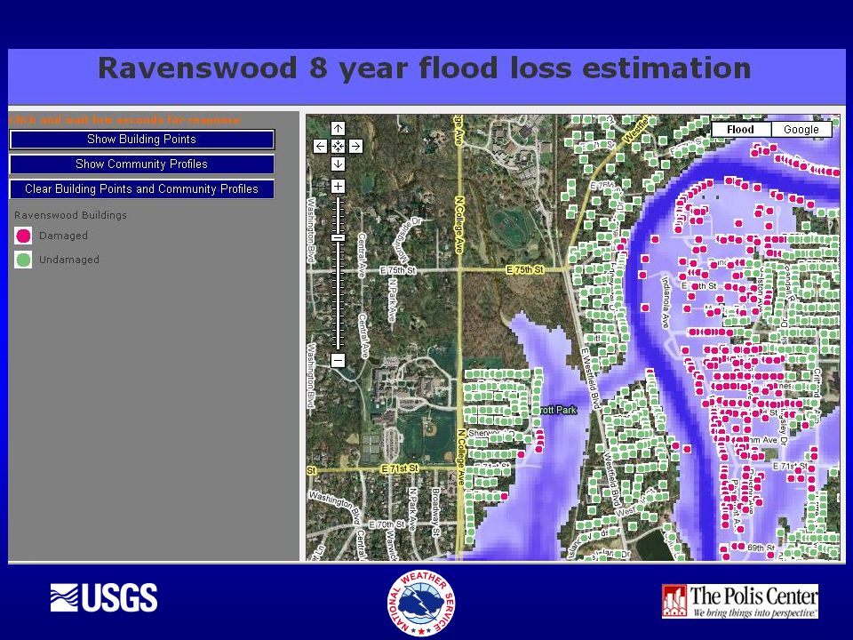
Ravenswood floods frequently and often damage is incurredRavenswood floods frequently and often damage is incurred IMA Virginia B. Fairbanks Art and Nature Park is partially situated in the flood plain: occasional floodingIMA Virginia B. Fairbanks Art and Nature Park is partially situated in the flood plain: occasional flooding Availability of high-resolution digital elevation data, detailed building inventory data, USGS/NWS data and extensive historic high-water mark and flood elevation dataAvailability of high-resolution digital elevation data, detailed building inventory data, USGS/NWS data and extensive historic high-water mark and flood elevation data Why Ravenswood?

7
Approach Compile GIS and HAZUS-MH datasetsCompile GIS and HAZUS-MH datasets Calibrate, verify and implement hydraulic model called “FastMECH”Calibrate, verify and implement hydraulic model called “FastMECH” Automate data retrieval from USGS/NWS and create input files for FastMECHAutomate data retrieval from USGS/NWS and create input files for FastMECH Generate a flood grid for a simulated flood and perform a HAZUS-MH analysisGenerate a flood grid for a simulated flood and perform a HAZUS-MH analysis Install, test, and implement web and map serversInstall, test, and implement web and map servers

8
Data needs FastMECHFastMECH –Observed and predicted stream-flow and water-surface elevation data (USGS, NWS) –High-resolution digital elevation data HAZUS-MH HAZUS-MH –Observed and predicted flood-inundation maps from FastMECH –Default hazard, inventory and damage information for level 1 analysis and more detailed local information for the level 2 and 3 analyses
 –High-resolution digital elevation data HAZUS-MH HAZUS-MH –Observed and predicted flood-inundation maps from FastMECH –Default hazard, inventory and damage information for level 1 analysis and more detailed local information for the level 2 and 3 analyses")
9
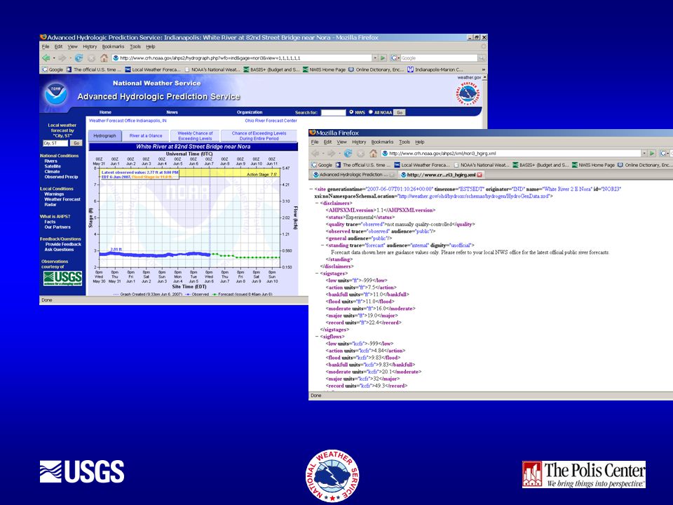
USGS provides real-time river stage and streamflow from streamgagesUSGS provides real-time river stage and streamflow from streamgages NWS uses streamgage data and sophisticated computer models to generate forecasts of stage/streamflowNWS uses streamgage data and sophisticated computer models to generate forecasts of stage/streamflow

10
NWS data Flow and water-surface elevation forecasts are generated by the NWS River Forecast CentersFlow and water-surface elevation forecasts are generated by the NWS River Forecast Centers Forecasts are based on regional rainfall- runoff relationsForecasts are based on regional rainfall- runoff relations Automated program will download the forecast data (XML) through the NWS Advanced Hydrologic Prediction ServiceAutomated program will download the forecast data (XML) through the NWS Advanced Hydrologic Prediction Service
 through the NWS Advanced Hydrologic Prediction ServiceAutomated program will download the forecast data (XML) through the NWS Advanced Hydrologic Prediction Service")
12
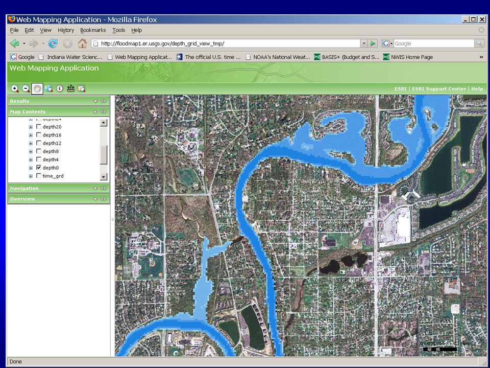
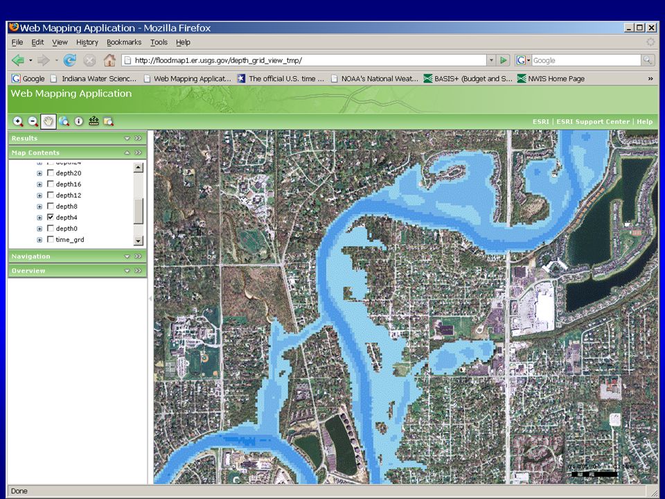
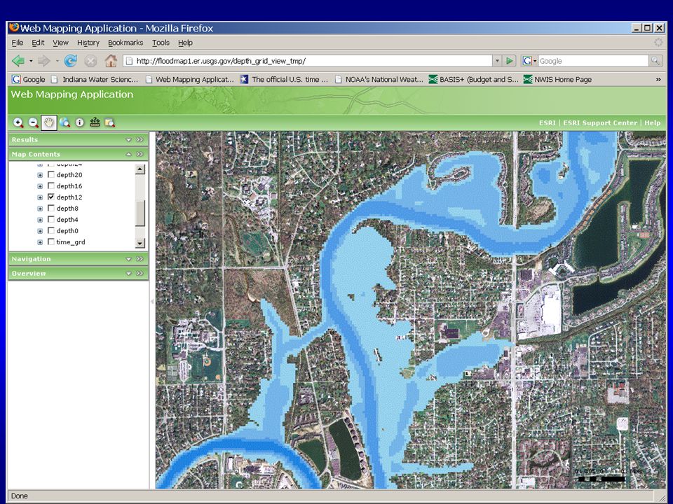
FaSTMECH Two-dimensional hydraulic flow modelTwo-dimensional hydraulic flow model Allows simulation of long reachesAllows simulation of long reaches Can handle flow regime changesCan handle flow regime changes Design to have shorter processing timeDesign to have shorter processing time Output: Water surface (depths), water velocity, flood arrival timesOutput: Water surface (depths), water velocity, flood arrival times
, water velocity, flood arrival timesOutput: Water surface (depths), water velocity, flood arrival times")
18
What is HAZUS-MH? FEMA created tool that helps communities reduce loss to property and life that may result from natural hazards.FEMA created tool that helps communities reduce loss to property and life that may result from natural hazards. ArcGIS 9.2 extension. Requires installation of Spatial Analyst 9.x (for flood modeling)ArcGIS 9.2 extension. Requires installation of Spatial Analyst 9.x (for flood modeling) Available from FEMA free of chargeAvailable from FEMA free of charge
ArcGIS 9.2 extension. Requires installation of Spatial Analyst 9.x (for flood modeling) Available from FEMA free of chargeAvailable from FEMA free of charge.")
19
Methodology EarthquakeFlood Hurricane

20
Levels of Analysis Level 3 Level 2 Level 1 Combinations of local and default hazard, building, and damage data Default hazard, inventory, and damage information Input data hazard specific Required User Effort and Sophistication

21
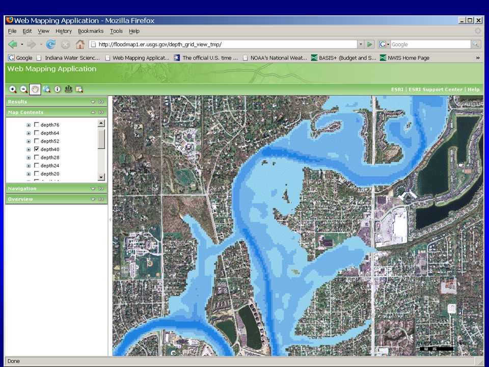
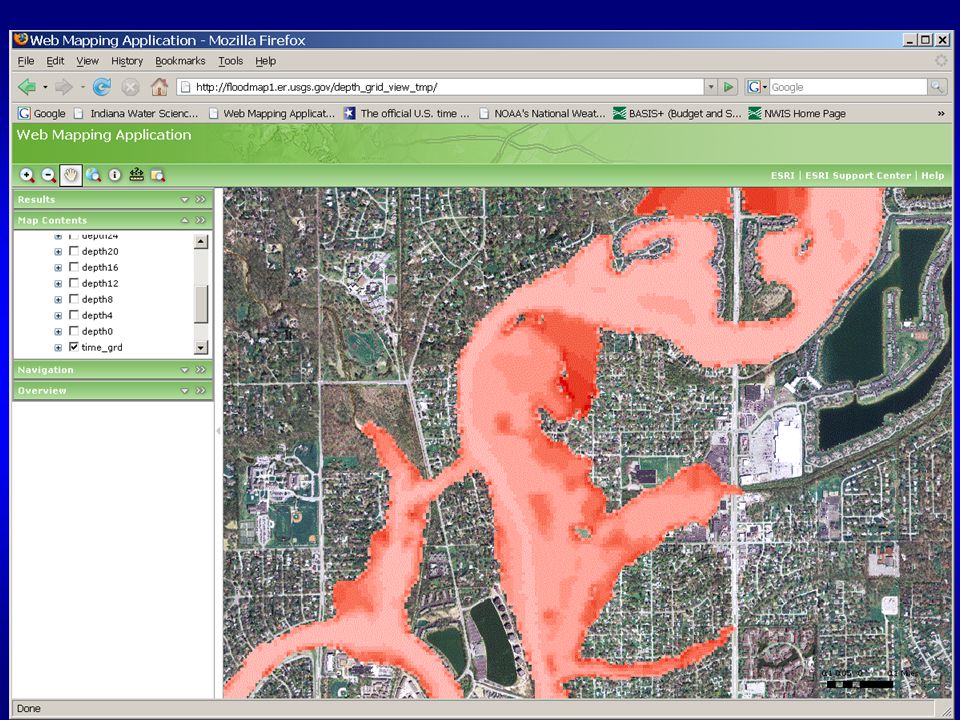
21 User Defined Flood Depth Grid HAZUS-MH allows users to point to one or more existing flood depth grids.HAZUS-MH allows users to point to one or more existing flood depth grids. USGS provided web-based delivery of GIS maps and downloadable flood grids for HAZUS-MH analysisUSGS provided web-based delivery of GIS maps and downloadable flood grids for HAZUS-MH analysis

23
Products Web-based near-real-time flood- inundation maps updated hourly.Web-based near-real-time flood- inundation maps updated hourly. Web-based forecast maps updated every 6 hrs per NWSWeb-based forecast maps updated every 6 hrs per NWS Downloadable flood grids for HAZUS-MHDownloadable flood grids for HAZUS-MH Results from the HAZUS-MH analysisResults from the HAZUS-MH analysis USGS ReportUSGS Report

24
Summary Products will come with disclaimers and error estimatesProducts will come with disclaimers and error estimates Highly expandable on a geographic basisHighly expandable on a geographic basis Many possibilities for future enhancements e.g. depth/velocity data for damage estimatesMany possibilities for future enhancements e.g. depth/velocity data for damage estimates Expands HAZUS-MH from a mitigation-only to a response toolExpands HAZUS-MH from a mitigation-only to a response tool Web and map server maintenance may be transferred to NWS and/or FEMAWeb and map server maintenance may be transferred to NWS and/or FEMA

25
Questions? Contact InformationContact Information Moon Kim: mkim@usgs.gov Sally Pavlow: Sally Pavlow: Sally.Pavlow@noaa.gov

Similar presentations


>")


 Coastal Hazards Analysis & Management Program (CHAMP)>")


