Download presentation
Presentation is loading. Please wait.

2
Crest- highest part of a wave Trough- lowest part of a wave Wavelength- horizontal length between crests. Wave height- vertical distance from crest to trough

3
* Tides are caused by the interaction of Earth, the moon, and the sun. * Why? GRAVITY * Gravity- the force that exerted (applied) by an object that pulls other objects toward it.
 by an object that pulls other objects toward it..")
4
* High tides occur about every 12 hours (and 25 minutes apart at each location along the coast). * Elza was at the beach at 8:00 am and noticed that it was high tide. Because she is a great Earth Science teacher, she knows that the next high tide will be at about ________?

5
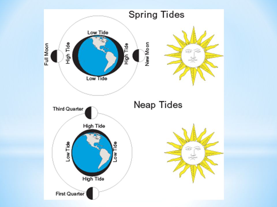
* Because the sun has a huge gravitational pull on the Earth, sometimes it and the moon pull together on the Earth’s waters.

6
Two times a month (new moon and full moon), the sun and moon are lined up. Their combined gravity creates the maximum range between high tide and low tide.

7
* In between spring tides (first and third quarters), the sun and the moon pull at right angles to each other. * This line-up produces a tide with the least difference between low and high tide.

9
* The Coriolis effect is the effect of the Earth’s rotation (Earth spinning on it’s axis), on the direction of winds and currents. * Northern Hemisphere- curve to the right * Southern Hemisphere- curve to the left

10
NORTHERN HEMISPHERE SOUTHERN HEMISPHERE

11
* Affect water to several hundreds of meters * Driven mainly by winds * Largest and most powerful surface current- the Gulf Stream (in North Atlantic Ocean, winds from west) * Carries warm water from the Gulf of Mexico, to the Caribbean Sea, then up the east coast of the United States.
 * Carries warm water from the Gulf of Mexico, to the Caribbean Sea, then up the east coast of the United States.")
12
* Climate- the pattern of temperature and precipitation typical of an area over a long period of time. * Currents carry warm water from the tropics toward the poles and bring cold water back toward the equator. * Surface currents warms or cools the air above it, affecting the climate of the land near the coast.

13
* Deep currents are caused by differences in density of the water close to the ocean floor. * Warm water moves to poles, and cools. * Ice forms at the poles, and when the water freezes it leaves the salt behind-increasing the salinity. * Temperature decreases, and salinity increases- the water becomes more dense and sinks flowing along the ocean floor as a deep current.

Similar presentations


 Affect water to a depth of several hundred meters Driven by winds Move in circular patterns in 5 major oceans. Because of Coriolis.>")

 Average depth of 3.6 km 2. Pacific largest ocean and feature on Earth’s surface a) Contains.>")


