Download presentation
Presentation is loading. Please wait.

1
OSGeo's Open Source Mapping Stack Beyond Features & Tools

2
Mil-OSS – 12/Aug/09 AtlantaOpen Source Geospatial Foundation Geographer, GIS Professional Author, Web Mapping Illustrated Executive Director & Charter Member Open Source Geospatial Foundation

3
Mil-OSS – 12/Aug/09 AtlantaOpen Source Geospatial Foundation OSGeo's Ecosystem

4
Mil-OSS – 12/Aug/09 AtlantaOpen Source Geospatial Foundation Geospatial Data Components DatabasesFiles Spatial data access API Real-time apps

5
Mil-OSS – 12/Aug/09 AtlantaOpen Source Geospatial Foundation Functional Components Creation Manipulation VisualisationAnalysis Data Conversion Mapping Spatial Analysis (GIS) Data Management
 Data Management")
6
Mil-OSS – 12/Aug/09 AtlantaOpen Source Geospatial Foundation OSGeo Project Stack PostGIS & Other DB GDAL / OGR (C++, etc) GeoTools (Java) FDO (C++) deegree Mapbender MapGuide MapServer GeoNetwork GRASS GIS - gvSIG – OSSIM - Quantum GIS Data Files (Imagery, vector, topography) OSSIM - GEOS Web Client Web Server Desktop Libraries Database MapBuilder – OpenLayers
 GeoTools (Java) FDO (C++) deegree Mapbender MapGuide MapServer GeoNetwork GRASS GIS - gvSIG – OSSIM - Quantum GIS Data Files (Imagery, vector, topography) OSSIM - GEOS Web Client Web Server Desktop Libraries Database MapBuilder – OpenLayers")
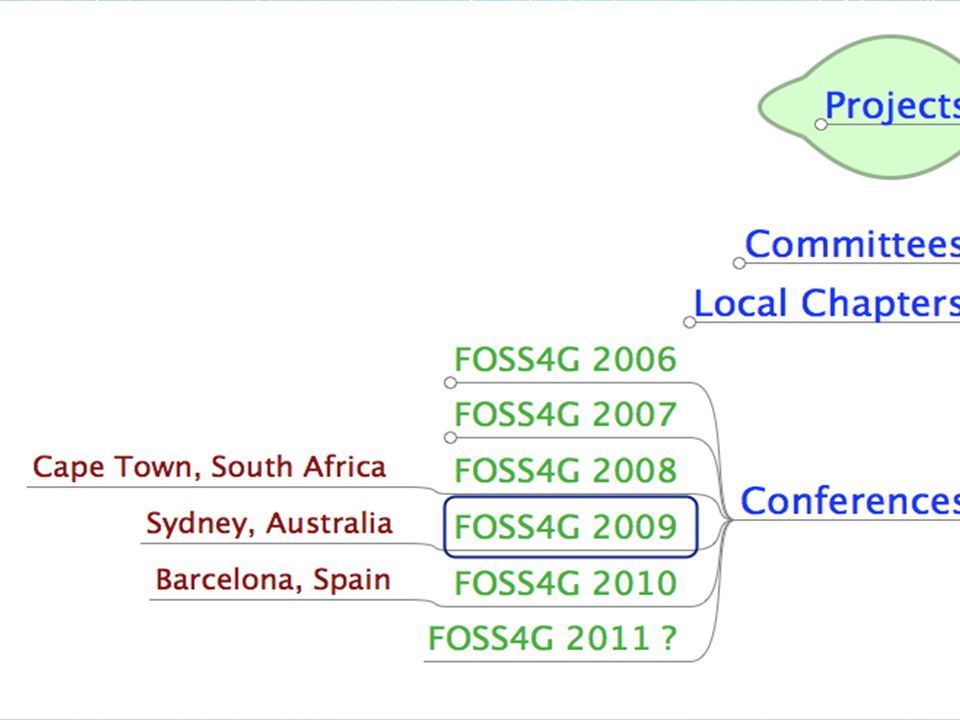
7
Mil-OSS – 12/Aug/09 AtlantaOpen Source Geospatial Foundation

9
https://confluence.prodevelop.es/display/pan More than OSGeo...

10
Mil-OSS – 12/Aug/09 AtlantaOpen Source Geospatial Foundation https://confluence.prodevelop.es/display/pan Re-use existing code!

11
Mil-OSS – 12/Aug/09 AtlantaOpen Source Geospatial Foundation

12
http://www.ohloh.net/stacks/151

13
Meeting Your Needs Required Features > Interoperability and standards** > Continuous improvement > Open development process (OSI) > Community support
 > Community support")
14
Mil-OSS – 12/Aug/09 AtlantaOpen Source Geospatial Foundation Meeting Your Needs Bonus features > Relationship to other projects > Modular options > Proprietary integration

15
Mil-OSS – 12/Aug/09 AtlantaOpen Source Geospatial Foundation Beyond Features & Tools > Build Internal Capabilities > Community Involvement

16
Mil-OSS – 12/Aug/09 AtlantaOpen Source Geospatial Foundation Build Internal Capabilities > Bypassing restrictive licensing > Build a professional toolkit > Expand your offerings > Custom fit/flexible solutions delivery

17
Mil-OSS – 12/Aug/09 AtlantaOpen Source Geospatial Foundation Community Involvement Wide range of supporters > Advocates, enthusiastic power users > Developers, writers, testers > Sponsors!

18
Mil-OSS – 12/Aug/09 AtlantaOpen Source Geospatial Foundation

23
Your Outlook for 2010 Aim high! > Expect more from your software > Get under the hood and re-use Expand your abilities > Break out – meet tomorrow's standards > Invest in your organisation Join Us! > Encourage your professionals > Support others and be supported

24
Mil-OSS – 12/Aug/09 AtlantaOpen Source Geospatial Foundation

25
Contact Me

Similar presentations


 : Exploring the cross-roads of organization, integration, and acceptance of OS Geospatial in the real world Presented.>")


 Desktop Web Feature Web Map Server.>")


