Download presentation
Presentation is loading. Please wait.

1
Topic VI: The Dynamic Earth

2
Earth’s Four Zones: Crust: the outside or surface—made up of mostly igneous rock with a thin shell of sedimentary rock on the outside

3
Crust types…. Oceanic Crust: only about 5 miles thin—made up of basalt (dense) Continental Crust: about 30 miles thick—made up of granite (less dense)
")
4
Mantle: the middle layer that the crust “floats” on—divided into 3 parts:
Rigid Mantle Asthenosphere Stiffer Mantle **the Lithosphere is the crust AND rigid mantle **the MOHO—boundary between the crust and mantle

5
Outer Core: liquid nickel & iron

6
Inner Core: solid because of high pressure / made of nickel and iron

7
Why Nickel & Iron?..... Meteorites!—more dense, sank to “center” of young molten Earth

8
What happens the deeper you go in the Earth?
Density, temperature, pressure all increase

9
Page 10

10
How do we know what Earth’s interior looks like?
Study Earthquake waves (like an ultrasound)
")
11
What does the heat from the core cause?
Continental Drift: the lithosphere (crust) is made up of solid plates that move (plate tectonics)
 is made up of solid plates that move (plate tectonics)")
13
Plates move because of heat that rises in the Asthenosphere due to density differences—called convection currents or cells

14
More Convection Currents….

15
Even More Convection Currents:

16
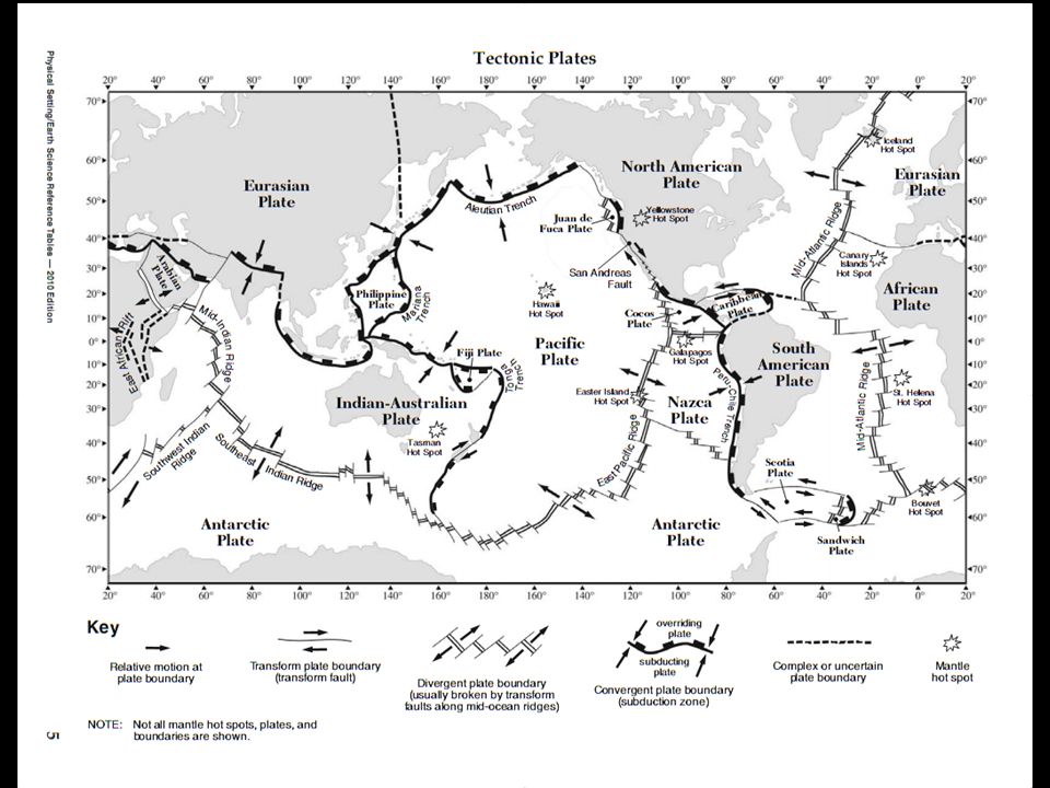
Plate Boundaries: areas on Earth where two plates are interacting with each other
**this is Where most Volcanoes / EQ’s / and Mountains Occur

17
Three Types of Plate Boundaries:
Convergent: plates collide (subduction zone—plate moves under another)
")
18
Divergent: plates move apart

19
Page 10

20
Transform: plates move side to side
USA

21
Hotspots: places in Earth’s crust with an unusually high heat flow (Hawaii)
")
22
**plates move only a few centimeters per year—about as fast as your fingernails grow

24
Evidence of Plate Motion:
Deformed (messed up) Rock Strata (layers) **because of gravity, all sedimentary rocks formed in horizontal layers (law of original horizontality)
 Rock Strata (layers) **because of gravity, all sedimentary rocks formed in horizontal layers (law of original horizontality)")
25
If not horizontal, the layers can be…
Tilted: force pushes rock layers from 1 side Force

26
Folded: forces push on rock layers from 2 sides (rocks are not broken)
")
27
Faulted: a break in the earth’s crust where movement occurs
Force Force

28
Williamsport, PA

29
Displaced Fossils: marine fossils found in rock layers several hundred feet above sea level (uplift)
")
30
Subsidence: sinking of rock layers (fossils being found deep underground)
")
31
Continents Fit together like a puzzle

32
Rock layers and fossils may be correlated (matched-up) across oceans
 across oceans")
33
Continuation of mountain chains from continent to continent

34
Evidence (fossils / rock) indicates that the climate was much different (coal found in Antarctica)
Coal forms in a tropical swamp

35
New York: Salt and Marine Fossils
Evaporated Ocean

36
Sea Floor Spreading (Divergent Plate Boundary)
")
37
Evidence of Sea-Floor Spreading:
Radioactive Dating found that as rocks get closer to the continents they get older **more on this later

38
Reversal of Magnetic Polarity: the Earth’s magnetic poles switch from time to time—this can be seen because of iron in basaltic ocean rocks

39
**Iron (magnetic) in the liquid basalt line up
like compass needles (stays when it hardens)
")
40
Mid-Ocean Ridge Cold Hot Cold Old Young Old

41
Earthquakes Earthquakes: a sudden shaking or trembling of rock layers along a fault line or plate boundary (the rock layers slip)
")
42
**energy is released and is transmitted by 2 types of waves
Primary or “P” waves (Compressional ) Secondary or “S” waves (Shear waves )
 Secondary or S waves (Shear waves )")
43
Seismographs: device that records the vibrations of earthquake waves
Seismic Stations: located around the world—used to study earthquake waves. Seismographs: device that records the vibrations of earthquake waves waves

44
P-waves: travel “phastest” so it arrives at the seismic stations “phirst”
Can travel through solid rock & magma (can travel through ALL Layers)
")
45
S-waves: travels slower so it arrives at seismic stations second
Only travel through SOLIDS—all layers EXCEPT LIQUID outer core and Solid Inner Core

47
Origin Time (what time EQ began at the epicenter)
Felt

48
Epicenter: point on the surface (city) directly above the focus (in the interior where the earthquake occurs) **P & S waves travel out in all directions

49
How is an earthquake’s epicenter located on a map?
Get P and S wave arrival times from 3 different seismic stations

50
Using the ESRT’s, find the distances from the epicenter for each station
**The larger difference between P and S wave arrival times means that the seismic station is farther away from the epicenter

51
Using the distances and a compass, draw 3 circles
**Where the three circles intersect the epicenter is located

52
**as these P & S waves travel, they change speed and bend (refract) as they enter different substances and / or different densities **this is how we know what Earth’s interior Looks like **remember the ultrasound?

53
Shadow Zone: a region on the Earth where no P and S waves are recorded (because of refraction & lack of s-waves)
")
54
Earthquakes in NY (rare)
**Remember Lat / long

55
Earthquake Strength Richter Magnitude Scale: measures the amount of energy an earthquake releases (uses seismographs) **1 (little energy) 10 (tremendous energy) Strong Weak
 10 (tremendous energy) Strong. Weak.")
56
Mercalli Intensity Scale: based on what damage people observe and shaking felt—can be used for historical earthquakes (newspaper articles) Roman Numerals: I (little) XII (lots)
 XII (lots)")
57
in the cases of both scales, the closer you are to the epicenter, the more you will feel the shaking—meaning the numbers will be higher the closer you are to the quake

58
Does this make sense….. The closer you are to the epicenter, both P & S waves will be found at nearby seismic stations Stations on the other side of the world may or may not pick up P & S waves

59
Earthquakes can cause:
Tsunamis: seismic sea waves (oceans)—can cause severe coastal damage
—can cause severe coastal damage.")
60
Landslides / avalanches
Fires Train / Car wrecks

61
Earthquake Emergency Planning
Get away from windows, chimneys Get under something strong (doorway) Don’t try to get outside (last < 30 sec)
 Don’t try to get outside (last < 30 sec)")
62
Volcanoes: mountain composed of extrusive igneous rocks that can erupt gases, lava, ash, and rocks onto Earth’s surface

63
Volcanic Hazards Ash (buries everything)
")
64
Lava (usually moves slow—people avoid)
Shooting, hot rocks (bombs)
")
65
Mudslides (ash mixes with snow and dirt from mountain tops)
")
Similar presentations


 is divided into solid.>")


Lithosphere.>")


