Download presentation
Presentation is loading. Please wait.

1
Hosted by Esri Official Distributor Utilizing Imagery in ArcGIS v10 & 10.1 Kenna Kelly South Pacific User Conference November, 2012 |Suva, Fiji

2
- Established in 1969 - World’s largest GIS software company - Market leading ArcGIS platform - Strong reputation, leading technology, highest R&D investment (over 20%) - Like Microsoft, IBM, Oracle and SAP – “de-facto” global IT standard - More than 350,000 customer sites, tens of millions of users - 400 NZ organisations and site licenses for all NZ universities (and University of South Pacific) - Extensive Utility user base globally & in NZ
 - Like Microsoft, IBM, Oracle and SAP – de-facto global IT standard - More than 350,000 customer sites, tens of millions of users NZ organisations and site licenses for all NZ universities (and University of South Pacific) - Extensive Utility user base globally & in NZ")
3
What is ArcGIS? Created by ESRI – worldwide leader in GIS Integrated collection of GIS software products Used to build a complete GIS for your organisation Enables wide deployment of GIS functions and business A Complete Integrated System DesktopServerMobileOnline ArcReaderArcReader ArcViewArcView ArcEditorArcEditor ArcInfoArcInfo EngineEngine Work GroupWork Group EnterpriseEnterprise ArcGIS MobileArcGIS Mobile ArcPadArcPad ContentContent Resource CentersResource Centers SERVER ONLINE DESKTOP MOBILE WEBEXPLORER

4
ArcGIS for Desktop Compilation & Editing Mapping & Visualization Catalog & Metadata Spatial Analysis & Modeling Authoring & Applying Geographic Knowledge Compilation Data Management Mapping Analysis Advanced Geoprocessing

5
ArcGIS Desktop Applications ArcCatalog ArcGlobe ArcScene ArcMap 3D Analyst Applications

6
ArcGIS and Support Ideas & voting ….Ideas & voting …. InvestmentInvestment

7
Improved LiDAR support LAS Dataset

8
Lidar in ArcGIS: The big Picture Solution for GIS end users - Not about lidar data production Operate on clean/classified lidar points Produce useful derivatives Perform Analysis Handle large datasets Both file and database oriented solutions Aspect Slope Elevation & Contours 3D Window in Desktop Profile Window in Desktop

9
Overview of LAS Support in ArcGIS 10.1 LAS files Mosaic dataset LAS dataset Terrain dataset Multipoint feature class Constraints

10
LAS Dataset New Data type File based Stores references to LAS files on disk Treats a collection of LAS files as one logical dataset

11
Licensing Standard or 3D or Spatial Analyst Extension - Create LAS dataset - Modify LAS dataset schema - Include in Mosaic dataset - Publishing requires Image extension for Server - View in 2D - Rasterize 3D Analyst Extension - Edit class codes - View in 3D - TIN based surface analysis

12
ArcGIS The Platform for Fully Integrated GIS and Imagery Integrating Imagery as core to GISIntegrating Imagery as core to GIS Management, Visualization, Analysis and DisseminationManagement, Visualization, Analysis and Dissemination Solution for wide range of imagery requirementsSolution for wide range of imagery requirements Maximizes the value of imageryMaximizes the value of imagery + + GIS

13
ArcGIS – A Platform for Complete Imagery Solutions Information Centric Workflows Enable Efficiency & Interoperability ESRI works closely with its partners ESRI works closely with its partners ArcGIS provides THE platform ArcGIS provides THE platform Partners provide domain expertise Partners provide domain expertise Automated Feature ExtractionAutomated Feature Extraction Multispectral AnalysisMultispectral Analysis Hyperspectral AnalysisHyperspectral Analysis RadarRadar Specialized Sensor SupportSpecialized Sensor Support Stereo DisplayStereo Display … DigitalGlobeGeoEye Trimble (Applanix) SPOTRapidEye Microsoft (Vexcel) Pictometry i-cubed PCI Geomatics Trimble (Inpho) MDA Information Systems LizardTech DAT/EMPurVIEWQcoherentTerraGo ITT VIS BAE Systems OverwatchDefiniens Clark Labs Service partners not listed
 SPOTRapidEye Microsoft (Vexcel) Pictometry i-cubed PCI Geomatics Trimble (Inpho) MDA Information Systems LizardTech DAT/EMPurVIEWQcoherentTerraGo ITT VIS BAE Systems OverwatchDefiniens Clark Labs Service partners not listed")
14
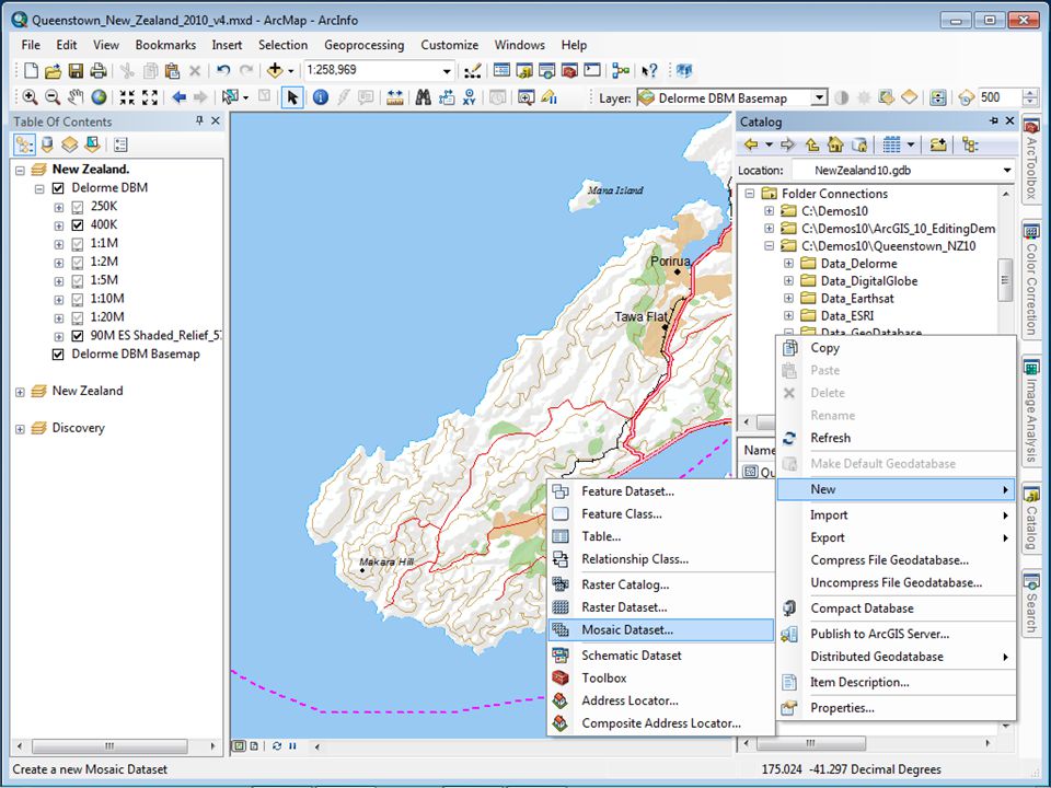
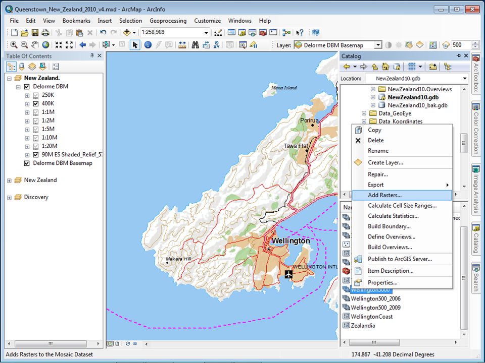
What is a Mosaic Dataset? Catalog/Library of Catalog/Library of - Imagery and rasters - Associated metadata - Processing functions to be applied Authored using ArcGIS Desktop v10.0 Authored using ArcGIS Desktop v10.0 Stored in Geodatabase Stored in Geodatabase Enables Enables - Dynamic Mosaicking - On-the-fly processing Recommend method to manage all imagery and rasters data

15
Optimum Model for Image Data Management Mosaic Dataset Optimum Model for Image Data Management Support for NEW at 10.1 - LAS files - LAS datasets - Terrain datasets Accessible as: - Image – Rasterized surface - Catalog – Detailed metadata and queries

26
Image Analysis Window Enhancement - Contrast, Brightness, Gamma,… - Dynamic Range Adjustment Interpretation - Sharpen, Top is Up,… Processing Functions - Clip, Mask - StackBands, NDVI, - Orthorectify, PanSharpen …. Has its own Layer List Access to accelerate display One click access to common magery ools One click access to common imagery tools

27
On-The-Fly Processing Create Multiple Products from a Single Source Utilizing the full image information content Imagery processed as accessedImagery processed as accessed ProcessesProcesses Stretch, Extract BandsStretch, Extract Bands Clip, MaskClip, Mask Reproject, Orthorectify, Pan SharpenReproject, Orthorectify, Pan Sharpen Vegetation Index, ClassifyVegetation Index, Classify Shaded Relief, Slope, AspectShaded Relief, Slope, Aspect Color CorrectionColor Correction … Applied toApplied to Individual rastersIndividual rasters Compete MosaicCompete Mosaic

28
Dynamic Mosaicking Mosaicking Multiple Images On Demand Fuse imagery from multiple sourcesFuse imagery from multiple sources User control of Mosaic MethodUser control of Mosaic Method By Date –’Latest’, ‘Closest to May 2001’By Date –’Latest’, ‘Closest to May 2001’ By Attribute – ‘Highest Sun Angle’, ‘Cloud Cover’By Attribute – ‘Highest Sun Angle’, ‘Cloud Cover’ By Viewpoint – North, South, East, WestBy Viewpoint – North, South, East, West Seamline – Feathered blendSeamline – Feathered blend User Query – ‘Landsat imagery, with no cloud, later than June 2001’User Query – ‘Landsat imagery, with no cloud, later than June 2001’ Set default - Users sees best available imagerySet default - Users sees best available imagery Utilizing information from overlapping images

29
ArcGIS – For Image Analysis Exploiting the Full Value of Imagery Search and Discovery - Simplified: As part of use - Query for imagery Processing - Image Analysis Window - On-the-fly processing Image Classification Tools - Traditional image classification Example Products

30
Image Classification Window Quick Access to Image Classification Tools Image Classification Toolbar - Supervise & Unsupervised - Class Probability - Principle Component Analysis Training Sample Manager - Define training areas graphically - Generate Signature Signatures applied as functions Requires Spatial Analysis Extension Not to be confused with Feature Extraction

31
ArcGIS Server 10.1 Image Extension A license (not a separate install) It extends the capabilities to serve collections of imagery or lidar data - Stored in mosaic datasets or a raster layer using the Mosaic function ArcGIS Server Serving: Rasters Raster layers *Mosaic datasets *Mosaic dataset layers
 It extends the capabilities to serve collections of imagery or lidar data - Stored in mosaic datasets or a raster layer using the Mosaic function ArcGIS Server Serving: Rasters Raster layers *Mosaic datasets *Mosaic dataset layers")
32
Sharing as an Image Service Provides access to imagery (raster data) through a web service “Web enabling” imagery - Single images - Large collection of images using mosaic datasets Access seamless mosaic Access as a catalog - Select/download selected images - Time aware Supports dynamic processing Standards: Esri, WCS, WMS, KML
 through a web service Web enabling imagery - Single images - Large collection of images using mosaic datasets Access seamless mosaic Access as a catalog - Select/download selected images - Time aware Supports dynamic processing Standards: Esri, WCS, WMS, KML")
Similar presentations