Download presentation
Presentation is loading. Please wait.

1
Charles Mader www.mccohi.com/tsunami.htm PACON - Paper and PowerPoint
TSUNAMI HAZARD TO Hawaii from a M9+ Event similar to 2004 Indian Ocean Tsunami Charles Mader PACON - Paper and PowerPoint

2
Dr. Herman Fritz surveys of December 26, 2004 Tsunami
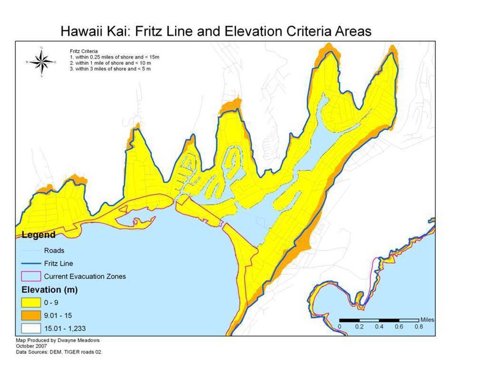
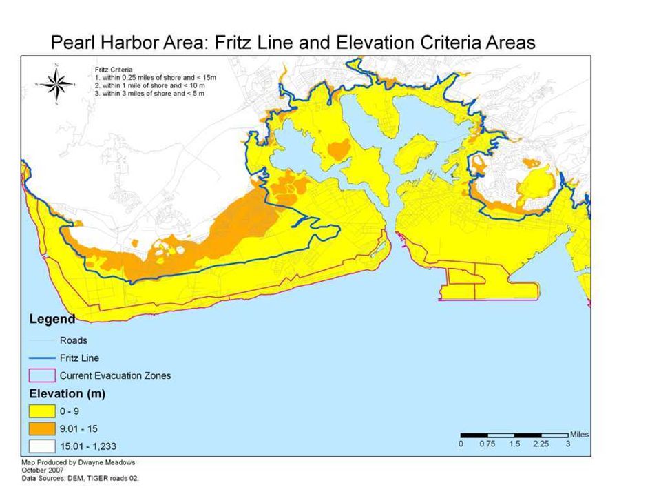
DEATH ZONE WAS AREA BELOW 10 METERS and LESS THAN 1 KILOMETER FROM SHORE.

3
Sri Lanka Multiple Tsunami Waves
Most witnesses described 3 main waves. The first knocked them off their feet, the second picked them up and carried them, often up to 50 km/hr, and the third bore them up to 15 meters high or sucked them under.

4
Fritz Indian Ocean Tsunami Survey Conclusions
Evacuate all areas below 15 meters above sea level and within 0.25 mile of shoreline or along rivers. Evacuate all areas below 10 meters above sea level and within 1.0 mile of shoreline or along rivers. Evacuate all areas below 5 meters above sea level and within 3 miles of shoreline.

5
The Fritz Indian Ocean Evacuation Criteria
Consider the 1946 historical observations as recorded in United States Tsunamis (page 66) Waipio Valley - 12 meter run-up amplitude Swept 1 mile into valley, pulled away homes and people and left only foundations Waikolu Valley, Molokai meter run-up amplitude Destroyed farms and buildings up entire valley. Makapuu Point, Oahu meter run-up amplitude Destroyed the nearby Ranch buildings with 3 waves (Helsley from wave deposits) leaving only foundations. Three wide valleys destroyed by the 1946 tsunami are historical evidence that the Fritz Indian Ocean Criteria is also appropriate for Hawaii .
 Waipio Valley - 12 meter run-up amplitude. Swept 1 mile into valley, pulled away homes and people. and left only foundations. Waikolu Valley, Molokai meter run-up amplitude. Destroyed farms and buildings up entire valley. Makapuu Point, Oahu meter run-up amplitude. Destroyed the nearby Ranch buildings with 3 waves (Helsley. from wave deposits) leaving only foundations. Three wide valleys destroyed by the 1946 tsunami are. historical evidence that the Fritz Indian Ocean Criteria. is also appropriate for Hawaii .")
6
www.mccohi.com/ tsunami/ hihazard.pdf

7
http:// www.lib.noaa.gov/about/news/meadows_012810.pdf
Dr. Meadows survived the 2004 Tsunami in Khao Lak, Thailand. Lead response for efforts for survivors and became involved in marine debris removal and coral restoration. January 28, 2010 NOAA Seminar –

8
Historical Tsunami Flooding of Hilo and current evacuation zone is close to Fritz Line and 9 meter elevation.

11
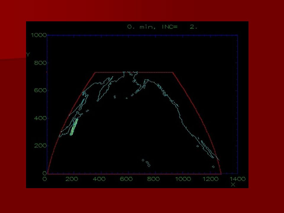
M9+ Tonga Trench Tsunami
At Source Tsunami 25 m High, 200 km wavelength, 15 minute period, 1100 km long.

12
3.2 meter High Tsunami off Oahu in 4321 m deep Ocean

13
M9+ Marianas Trench Tsunami

14
10 meter HIGH Tsunami off Oahu in 4321 m deep Ocean

15
M9+ Japan Trench A 10 meter high Tsunami moves down Island chain

16
15 meter High Tsunami South of Honolulu in 641 m deep Ocean

21
TSUNAMI HAZARD TO Hawaii from a M9+ Event similar to 2004 Indian Ocean Tsunami

22
12/26/2004 Indian Ocean Tsunami - 300,000 Deaths
TSUNAMI Science and Hawaii Hazards PowerPoints PowerPoints with Movies are available on NMWW DVD 12/26/2004 Indian Ocean Tsunami - 300,000 Deaths 17/8/1955 Lituya Bay 1600 ft High Tsunami 8/27/1883 Krakatoa Volcanic Explosion generated Tsunami Projectile Impact and Explosion Generated Waves Tsunami Hazard for Hawaii Kai, Hawaii Hawaii Tsunami Hazard from M9 Earthquake like 12/26/2004 PDF- KT Asteroid Impact - Asteroid Hazard to Life on Earth Dr. Walker Hawaii Historical Tsunami Hazard Evaluation Meadows PDF Report on Hawaii Tsunami Zone Hazards PDF 6/2010 PACON Paper on Hawaii M9+ Tsunami Hazards 6/2010 PACON PowerPoint on Hawaii M9+ Hazards

Similar presentations