Download presentation
Presentation is loading. Please wait.

1
INDIAN OCEAN TSUNAMI Version with MOVIES on NMWW DVD
December 26, 2004 Banda Aceh Krabit, Indonesia

3
TSUNAMI WAVES Caused by Earthquakes under Ocean, or other events – landslides, volcanic eruptions, asteroid impacts, etc. In Deep Ocean the Tsunami Wave is only about 3 feet high but 100 miles wide and moving at speed of a jet airplane.

5
Alfred Wegner observed that South America and Africa continents fit like a gig saw puzzle
Proposed Continental Drift of Plates (Plate Tectonics) and that 200 million Years ago a super continent of Pangaea existed.
 and that 200 million. Years ago a super continent of Pangaea existed.")
7
SEA FLOOR SPREADING Occurs along the Mid-Atlantic Ridge pushing the African and European Plates away from the North and South American Plates at about 1 inch/year This then pushes the Pacific Ocean floor under the Plates on the opposite side of America Plates and Euroasian and Africa Plates

9
Earthquakes result from Sea Floor Spreading along the
Mid-Atlantic Ridge that pushes the Continents over the Pacific Ocean Floor.

11
Earthquakes since 1990

12
Mag 9, 0.58 GMT, 10 km Deep, 250 km SSW of Banda Ache, Indonesia, ~1 m high Tsunami, min period, ~350 km wavelength, 200 m/sec

14
FACTS Model – PMEL - Titov

15
Depth Gauge Record of Mercator anchored 1 mile from coast of Phuket, Thailand. Time in hours, Depth in Meters. Reflected Off Coast -2.7, +3.9, -0.5, +1.7, -0.6, +4.9 meters in 41 minutes

16
Jason 1 Altimetry Satellite Tracks
TSUNAMI

17
30 Minute Period, 350 km Wave Length, 200 m/s or 750 km/hr having traveled 1500 km in 2 hours since earthquake – 1 meter max wave height. TSUNAMI

18
Banda Aceh City, Sumarta Digital Globe Satellite Photos
Before After

19
Damage map of Banda Aceh showing the impact of tsunamis wave fronts from two directions. The numerals indicate the tsunami elevation in meters near the beach (white) and flow depth inland (black). (Damage map source: UNOSAT, Tsunami data: Borrero et al. 2006, Jaffe et al., 2006, Matsutomi et al., 2006).
 and flow depth inland (black). (Damage map source: UNOSAT, Tsunami data: Borrero et al. 2006, Jaffe et al., 2006, Matsutomi et al., 2006)..")
27
Tug Boat and Barge

28
Cement Plant and Survivor

30
___ 15 meters Men holding 5 meter staff ___

32
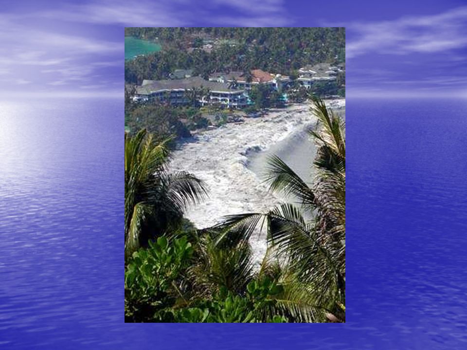
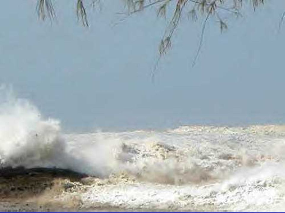
Phuket, Thailand

35
Phi Phi, Thailand Before Tsunami Initial Withdrawal

39
Phi Phi After Tsunami

40
Phi Phi After Tsunami

41
Phi Phi Don Island – Pictures taken from Aragon Yacht ¾ mile from land of other Yachts and Boats
Withdrawal – Rocks normally underwater First Wave Run-up – 3 minutes later

42
4 minutes later 5 minutes later

43
Trinkat, Nicobar-Andaman Islands

44
Khao Lak, Thailand – Pictures taken by Canadians – John and Jackie Knill – before they died
Withdrawal

50
South India After Tsunami

51
Digital Globe Satellite Photos
Kalutara, Sri Lanka Before Recession Flooding

52
Sri Lanka After Tsunami

53
Sri Lanka After Tsunami

54
Sri Lanka After Tsunami

55
Train traveling from Colombo to Galle hit by >30 ft high Tsunami at Telwatta about 15 miles from Galle.

56
Telwatta, Sri Lanka Train

57
Over 800 were Killed- Train 200 yards from shore
Over 800 were Killed- Train 200 yards from shore. People from town climbed on top of train after first wave then killed by second wave.

58
Sri Lanka 10 meter Regions in Red

59
MALDIVES Islands – B. Keating Study
Maldive Islands

60
Location Map From Coleman (2000)
")
61
Metal Roofing Cut People
Maldives After Tsunami Metal Roofing Cut People

62
Walls carried by flood injured people
Maldives After Tsunami Walls carried by flood injured people

63
Maldives After Tsunami
Water Catchment Tank

65
Krabit, Phuket, Indonesia – THEY ALL SURVIVED!

66
PACIFIC TSUNAMI WARNING CENTER Ewa Beach, Hawaii
US Department of Commerce / National Weather Service

67
WC/ATWC - Palmer, Alaska

68
WC/ATWC

69
Earthquake Data Processing
WC/ATWC EarlyBird Seismic Processing System Developed for Fast evaluation of Big quakes Graphical interaction to refine automatic results Redundant backup operates concurrently (communications and hardware).
.")
70
Sea Level Data Display and Analysis
Data acquired at WC/ATWC from NOS, PTWC, and other centers’ sites 200+ tide gage signals 6 DART stations Data displayed with predicted tide and residuals Data real-time, triggered, or satellite delayed (hourly).
.")
73
Far-Field Prediction Approach
Determine likely fault parameters for large quakes in main tsunami generating zones of the Pacific Model quakes of different magnitudes for each zone (> 200 total models) Save maximum amplitudes at tide gages, DARTs, and other places of interest (100+ saved/model)
 Save maximum amplitudes at tide gages, DARTs, and other places of interest (100+ saved/model)")
74
TYPES OF TSUNAMI MESSAGES
INFORMATION BULLETIN: Large earthquake but no tsunami threat (6.5 <= Mw < 7.5) Watch/Warning: Large, Shallow, under water, Earthquake (Mw >= 7.5) WATCH: First wave is 3-6 hours away WARNING: First wave is < 3 hours away Pacific-Warning: Confirmed destructive waves moving across the Pacific
 Watch/Warning: Large, Shallow, under water, Earthquake (Mw >= 7.5) WATCH: First wave is 3-6 hours away. WARNING: First wave is < 3 hours away. Pacific-Warning: Confirmed destructive waves moving across the Pacific.")
75
Sumatra Earthquake Mw = 9.3 Rupture Length ~ 1200km
Source Duration ~ 600s Rupture propagated South To North => Generated Basin wide Destructive tsunami that killed > 300,000 people

76
Sumatra Earthquake PTWC TIMELINE (GMT) 00:59 Sumatra EQ Starts
01:07 Watchstanders paged by digital alarm 01:09 PTWC has location 01:09 Sumatra EQ Stops 01:14 PTWC issues TIB with Mw=8.0 02:04 TIB issued with Revised magnitude 8.5 No Tide Gauges in Region 05:00 Wire reports of deaths In Thailand and Sri Lanka

77
Travel Time Back Track Wave Tracing Back to Source SLIP and RAKE Model
PB P S Travel Time Back Track Wave Tracing Back to Source SLIP and RAKE Model Regional and Tele-Surface Waves. Mw = 9.1 Where was the Missing Moment Released?

78
4hr After having learned that there was a destructive
tsunami, PTWC set about reaching Nations ahead of the wave.

79
March 28, 2005 Mw=8.2 Upgraded To 8.5 then to 8.7!! No reports of Tsunami Damage. One Degree South of Where Dec 26 event Started. Aftershock? Faulting continuing Southwards?

80
Conclusions The Tsunami caused by the Sumatra EQ killed >300,000 people because there was no Warning System. Source region for Sumatra Tsunami extends from Banda Aceh through the Nicobar Islands. We need a method for estimating size of great earthquakes within a time frame useful to the Tsunami Warning System.

81
Tsunami Warnings If you are at the beach and feel an earthquake – GO TO HIGH GROUND (>100 feet above MSL) If the water level drops below low tide level – GO TO HIGH GROUND If you hear a siren near the beach – GO TO HIGH GROUND If in or near multi-storied concrete building – GO UP IN BUILDING ABOVE THIRD FLOOR

Similar presentations


 2. Underwater or coastal volcanic.>")


