Download presentation
Presentation is loading. Please wait.

1
A rapid assessment of the MyOcean catalogue 3.0 products for application to environmental issues (WFD, MSFD, WG DIKE, EEA): nutrients and eutrophication only Giordano GiorgiNiels KinnegingGerben de Boer
: nutrients and eutrophication only Giordano GiorgiNiels KinnegingGerben de Boer")
3
What MyOcean catalogue offers for MSFD

4
Example search result North Atlantic

5
Example search result Mediterranean Sea

6
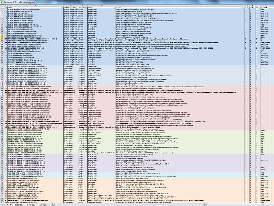
MyOcean catalogue: 107 products All 1-line descriptions would fit on 2 A4 Excel pages (next slide) Catalogue offers also texts + plan views preview to form a booklet 9 products for optical/biological North Sea (4 products multiyear) 8 products for optical/biological Med Sea (2 products multiyear) No easy drilling down on all properties of the models like Spatial and vertical resolution Time span Data source composition: model, in situ, satellite (previous slide) Example: North Sea model comparison Lenhart et al, 2010, JMS
 Catalogue offers also texts + plan views preview to form a booklet 9 products for optical/biological North Sea (4 products multiyear) 8 products for optical/biological Med Sea (2 products multiyear) No easy drilling down on all properties of the models like Spatial and vertical resolution Time span Data source composition: model, in situ, satellite (previous slide) Example: North Sea model comparison Lenhart et al, 2010, JMS")
10
MyOcean data types MyOcean offers 4 groups of products relevant for environment. Data source type is less important than being multi-year. Archived analyses/forecasts, hindcasts, reanalyses, reprocesing 1.Non-assimilated model simulations without data assimilation (free runs) 2.Assimilated model simulations data assimilation with in situ only data assimilation with in situ + satellite data assimilation with only satellite 3.Remote sensing collections pure satellite collations data assimilation (OI) with in situ 4.Aggregations of in situ data Homogenized regional aggregations modelin situsatellite yes-- - - Yesyes -- - - - INDUCTIVE METHODS ONLY DATA, NO THEORY DEDUCTIVE METHODS THEORY ONLY HYBRID METHODS THEORY AND DATA
 2.Assimilated model simulations data assimilation with in situ only data assimilation with in situ + satellite data assimilation with only satellite 3.Remote sensing collections pure satellite collations data assimilation (OI) with in situ 4.Aggregations of in situ data Homogenized regional aggregations modelin situsatellite yes Yesyes INDUCTIVE METHODS ONLY DATA, NO THEORY DEDUCTIVE METHODS THEORY ONLY HYBRID METHODS THEORY AND DATA.")
11
MyOcean data services: 3 INSPIRE levels INSPIRE requires a 3-step availability of geospatial data 1.Discovery: without MyOcean authentication >Yes: catalogue for interactive manual access >No: web service: OGC CSW machine-readable catalogue service 2.View: without MyOcean authentication >Yes: view OGC WMS inside MyOcean webviewer (next slides) >No: web service: OGC WMS layer into user applications. (next slides) Technically up-and-running, but not offered/supported. 3.Download: fully MyOcean authenticated download mechanisms >Yes: manual OGC netCDF files via internet browser (ftp or GUI) >Yes: automated OGC netCDF file machine2machine (M2M) download (ftp or python client for experts) >No: INSPIRE and OGC download standards not offered: –OPeNDAP+ OGC WCS + OGC WFS + OGC SOS –OPeNDAP technically up-and-running but not offered/supported.
 Technically up-and-running, but not offered/supported. 3.Download: fully MyOcean authenticated download mechanisms >Yes: manual OGC netCDF files via internet browser (ftp or GUI) >Yes: automated OGC netCDF file machine2machine (M2M) download (ftp or python client for experts) >No: INSPIRE and OGC download standards not offered: –OPeNDAP+ OGC WCS + OGC WFS + OGC SOS –OPeNDAP technically up-and-running but not offered/supported..")
12
MyOcean does not yet offer INSPIRE/OGC web services after Baart et al, 2012, Transactions in GIS, 2012, 16(2): 249–265, (doi: 10.1111/j.1467-9671.2012.01312.x)
: 249–265, (doi: /j x)")
13
Inspire viewing service now offered in MyOcean viewer

14
NOT offered in catalogue: viewing service for external clients Example: MyOcean WMS can be added to webGIS viewer of Royal Dutch met office (although it already works under the hood, without service)
")
15
MyOcean offers large scale models: Simulations for MSFD require local models + knowledge Local model comparison for OSPAR CP scenarios MyOcean-like global models were needed supply outer boundary conditions supply suspended sediment fields as CHL analysis suffers most from suspended sediment uncertainty The generated multi-year local product are not in MyOcean. Europe should centrally harvest these local models too, just like they harvest local in situ data.

16
Foster local models over single top-down product This North Sea OSPAR example shows: models and remote sensing need local refinements for ocean color: MyOcean now offers a few central models Essential for boundary conditions for local models: continue MyOcean should also facilitate dissemination of local models: harvest models from all over Europe, like NOOS does For MSFD local knowledge is essential: this local knowlegde is only in implemented in local models. For science: improve discrepancies global and local models Collecting local models and local remote sensing data products: has positive side effect for overlapping parts in favor of in situ In situ will be more important: ground-truth satellite products. Once ensembles exist: multiple values at same position facilitates: Round robin comparisons Benchmarking to optimize improvementa Odd ones out need to fix their model physics

17
Foster local models over single top-down product This North Sea OSPAR example shows: models and remote sensing need local refinements for ocean color: MyOcean now offers a few central models Essential for boundary conditions for local models: continue MyOcean should also facilitate dissemination of local models: harvest models from all over Europe, like NOOS does For MSFD local knowledge is essential: this local knowlegde is only in implemented in local models. For science: improve discrepancies global and local models

18
MyOcean: examples NOOS and ESA NOOS approach is good example for what MyOcean can offer MSFD: collect output from many tailored local models ESA CCI projects with round robins are good example for what MyOcean can offer MSFD: compare processing of many local remote sensing algorithms (Inherent Optical Properties, IOP) that differ per watermass, i.e. per area of 100x100km 2 for turbid Case II waters like North Sea, Irish sea, Channel.

19
Environmental assessment: link pressure-activities Environmental assessment need a strong linkage between level of pressure/impacts and activities/driving forces (DPSIR) MyOcean models/products + local models/products describe level of pressure (e.g. nutrients concentration) >Level of pressure better transformed to grid representation Joint analysis with riverine discharge and waste water discharge is needed GES indicators need to be implemented considering also programs of measures
 >Level of pressure better transformed to grid representation Joint analysis with riverine discharge and waste water discharge is needed GES indicators need to be implemented considering also programs of measures.")
20
Example nitrate concentration for IT from MyOcean

21
Example river discharge for Med Sea

22
Summary MyOcean already offers products useful for MSFD MyOcean should officially provide WMS service: viewing MyOcean products in client WMS viewers (INSPIRE requirement). Technically MyOcean already offers this, but unsupported. MyOcean should provide INSPIRE web services for grids in addition to manual/batch download mechanisms (OPeNDAP, OGC WCS, WFS). Technically MyOcean already offers OPeNDAP, but unsupported. WCS allows for requesting data at tailored local grids for easy local DPSIR analysis. Foster MyOcean dissemination of dedicated models products already prepared for regional seas (e.g. NOOS, ESA, OSPAR) Suite of model results support assessment Suite of remote sensing algorithms support assessment WG DIKE should play active role as end-user in MyOcean/ECOMF
. Technically MyOcean already offers OPeNDAP, but unsupported. WCS allows for requesting data at tailored local grids for easy local DPSIR analysis. Foster MyOcean dissemination of dedicated models products already prepared for regional seas (e.g. NOOS, ESA, OSPAR) Suite of model results support assessment Suite of remote sensing algorithms support assessment WG DIKE should play active role as end-user in MyOcean/ECOMF.")
23
Proposal of Workshop Proposal: Organize a dedicated workshop to specifically discuss MyOcean products applications to MSFD implementation of GES indicators Main topics Overview of multiyear MyOcean products with focus on resolution and level of confidence Central vs local models for MSFD subregions: boundary conditions, downscaling MyOcean product output representation: OGC WMS and grid (INSPIRE: OGC WCS, OGC WFS) MSFD GES indicator implementation DPSIR approach and programs of measures
 MSFD GES indicator implementation DPSIR approach and programs of measures")
Similar presentations


 for INSPIRE Michel Grothe,>")


 and Twentieth Century Reanalysis at NCAR Thomas Cram - NCAR, Boulder, CO Gilbert Compo & Chesley McColl.>")


, 3-5 June 2013.>")
 for INSPIRE Mickael.>")
 Meixia Deng and Liping Di.>")
 By Dick M.A. Schaap.>")
