Download presentation
Presentation is loading. Please wait.

1
MOTTO : EXCELLENCE AND VIRTUE

2
MT 143 TERRESTRIAL NAVIGATION 1 Validated by: Capt. Armando A. Ternida

3
COURSE OBJECTIVES : A student should at the minimum be able to: 1. Discuss the basic principles of navigation. 2.Enumerate the factors involved in the field of navigation. 3.Demonstrate the proper procedures of using the compass, position and position lines and official logbook. 4.Discuss the basic knowledge in passage planning.

4
N A V I G A T I O N is a process of directing the movements of a craft expeditiously and safely from, one point to another. The word navigate is from the Latin navigatus, the past participle of the verb navigere, which is derived from the words navis, meaning “ship”, and agere, meaning “to move “ or “to direct”.

5
KINDS OF NAVIGATION I. MARINE NAVIGATION- I. MARINE NAVIGATION- navigation of watercraft navigation of watercraft a. Surface navigation- vessel a. Surface navigation- vessel of the surface of the water of the surface of the water b. Underwater navigation- b. Underwater navigation- submerged vessel submerged vessel II. AIR NAVIGATION II. AIR NAVIGATION III. LAND NAVIGATION III. LAND NAVIGATION

6
PRINCIPAL DIVISION OF NAVIGATION 1. DEAD RECKONING- is the determination of position by advancing a known position for courses and distances. - position so determined is called a dead reckoning position.

7
DEDUCED RECKONING- determination of position by use of the course and speed expected to be made good over the ground, making an estimated allowance for disturbing elements such as current and wind, a position so called estimated position.

8
2. PILOTING (OR PILOTAGE)- is navigation involving frequent and continuous determination of position or a line of position relative to geographic points, and usually requiring need for close attention to the vessel’s draft with respect to the depth of water. - practiced in the vicinity of land, dangers, etc.
- is navigation involving frequent and continuous determination of position or a line of position relative to geographic points, and usually requiring need for close attention to the vessel’s draft with respect to the depth of water. - practiced in the vicinity of land, dangers, etc..")
9
3. RADIONAVIGATION- is a navigation using radio waves for determination of position or of line of position. a. Radar Navigation- involves the use of radio waves. usually in the centimeter band. b. Satellite Navigation- involves the use of artificial earth satellites for determination of position.

10
RADAR/ARPARADAR/ARPA

12
GLOBAL POSITIONING SYSTEM/GPS

14
4. ELECTRONIC NAVIGATION- is used to refer to navigation involving the use of electronics in any way. - includes the use of the gyrocompass for steering and the echo sounder when piloting. Electronics- is the science and technology relating to the emission, flow, and effects of electronics in a vacuum or through a semiconductor, and to systems using devices in which this action takes place.

16
STEERING GYROCOMPASSSTEERING GYROCOMPASS MASTER GYROCOMPASSMASTER GYROCOMPASS

17
CENTER GYROCOMPASS REPEATER

18
STARBOARD GYROCOMPASS REPEATER

19
PORT GYROCOMPASS REPEATER

20
MAGNETIC COMPASS

21
ECHO SOUNDER

23
5. CELESTIAL NAVIGATION navigation using information obtained from celestial bodies.

24
A passage plan is a comprehensive, berth to berth guide, developed and used by a vessel’s bridge team to determine the most favorable route, to identify potential problems or hazards along the route, and to adopt bridge management practices to ensure the vessel’s safe passage. VOYAGE PLANNING

25
Four Elements to a Passage Plan Appraisal Planning Execution Monitoring

26
Appraisal: Denotes gather as much safety and navigation information to give you a safe voyage. Before planning can commence, the charts, publications and other information appropriate for the voyage will need to be gathered together and studied.

27
Appraisal…..

28
1. Chart Catalogue 2. Navigational Charts

29
3. Ocean Passages for the World 4. Routeing Charts & Pilot Charts

30
5. Sailing Directions & Pilot Book Admiralty Sailing Directions (Pilots) Sailing Directions are complementary to Admiralty Standard Nautical Charts and worldwide coverage is provided in 74 volumes.
 Sailing Directions are complementary to Admiralty Standard Nautical Charts and worldwide coverage is provided in 74 volumes..")
31
Admiralty List of Lights and Fog Signals series gives listings of all lighthouses, lightships, lit floating marks (over 8m in height), fog signals and lights of navigational significance. Each publication lists the characteristics of lights and fog signals, together with the equivalent foreign language light descriptions.

32
7. Tide Tables The tables give daily predictions of the times and heights of high and low waters for over 230 standard and 6,000 secondary ports in UK and Ireland; Europe; Indian Ocean and the South China Sea and the Pacific Ocean. The tables briefly outline methods of prediction and the effect of meteorological conditions on tides and they comment on special tidal problems in the area.

33
8. Tidal Stream Atlases The tables give daily predictions of the times and heights of high and low waters for over 230 standard and 6,000 secondary ports in UK and Ireland; Europe; Indian Ocean and the South China Sea and the Pacific Ocean. The tables briefly outline methods of prediction and the effect of meteorological conditions on tides and they comment on special tidal problems in the area.

34
9. Notices to Mariners 10. Ships’ Routeing Notices to Mariners it gives important changes to charts and lights (including temporary ones), radio signals and sailing directions are listed in Weekly Admiralty Notices to Mariners. 34
, radio signals and sailing directions are listed in Weekly Admiralty Notices to Mariners. 34.")
35
11. Radio Signal Information 12. Climatic Information

36
13. Load Line Chart 14. Distance Tables 36

37
16. Radio & Local Warning 15. Electronic Navigation System Handbooks

38
17. Draught of Ship 18. Owner’s & Other Sources 19. Personal Experience 20. The Mariner’s Handbook

39
2. Planning Only official nautical charts should be used An ocean passage requires less planning of courses etc. Navigation in coastal waters requires concentrated preparations.

40
Passage Planning Elements No-go Areas Margins Of Safety Charted Tracks Course Alteration & Wheel Over Parallel Indexing Abort and Contingencies Natural Transit, Clearing Marks & Head Mark Clearing Bearings Leading Lines 40

41
Execution: The master should find out how long his intended voyage should take, making sure he has enough water and fuel for the voyage He should take into account any weather conditions expected on the voyage Any areas of high traffic density that would make him deviate from his course (he should if possible make a plan to keep well clear of these areas).
.")
42
Monitoring: chart This is the act of checking your position often on a chart and that you remain in a safe distance from any danger areas (land) Parallel Indexing should be used when you are alongside any hazards to maintain a safe distance.
 Parallel Indexing should be used when you are alongside any hazards to maintain a safe distance.")
43
THE CHART The chart is a specialised map used by the navigator. On the chart is depicted all the necessary information which the navigator requires in order to safely navigate the ship..

44
EARTH SYSTEM OF COORDINATES

45
For most navigational purposes, the earth can be considered a sphere, but, like the other planets, the Earth is approximately an oblate spheroid. The polar diameter is less than the equatorial diameter, and the meridians are slightly elliptical, rather than circular (flattened at the poles, bulging at the equator). E A R T H
. E A R T H.")
46
EARTHEARTH SYSTEMSYSTEM

47
GREAT CIRCLE the line of intersection of a sphere and a plane through the center of the sphere

48
the line of intersection of a sphere and a plane which does not pass through the center of the sphere

50
SPHERICAL TRIANGLE A spherical triangle is that part of the surface of a sphere bounded by three arcs of great circles. The bounding arcs are called the sides of the spherical triangle and the intersection of these arcs are called the vertices. The angle formed by two intersecting arcs is called a spherical angle.

51
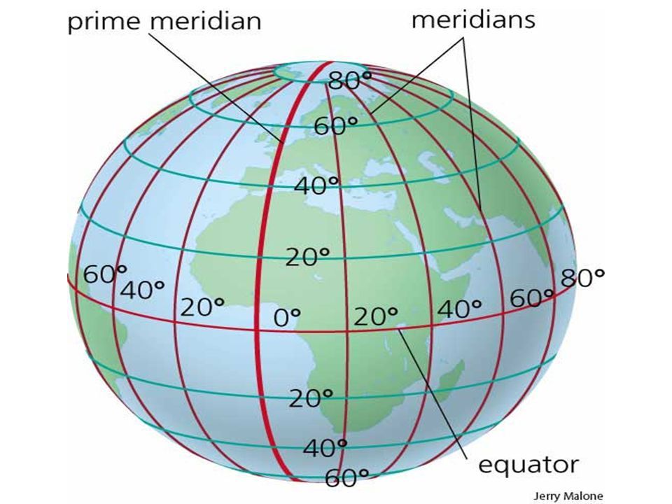
1. Equator- the terrestrial great circle whose plane is perpendicular to the polar axis. It is midway between the poles.

52
2. Meridians- a great circle through the geographical poles of the earth. All meridians meet at the poles, and their planes intersect in a line, the polar axis.

53
Upper Branch of the Meridian- that half of the Meridian through the place or the branch containing the position of the observer and the opposite branch is called the lower branch.

56
3. Prime Meridian- the meridian used as the origin for measurement of longitude. Also called as Greenwich Meridian.

59
4. Parallel of latitude- a circle on the surface of the earth, parallel to the plane of the equator. It connects all points of equal latitude..

60
5. Latitude- the angular distance from the equator, measured northward or southward along a meridian from 0 0 at the equator to 90 0 at the poles. It is designated north (N) or south (S) to indicate the direction of measurement.
 or south (S) to indicate the direction of measurement..")
61
DEGREES, MINUTES, & SECONDS 1 MINUTE 1 DEGREE 12 SEC0NDS YOU WILL DETERMINE DEGREES, MINUTES, & SECONDS ON THE CHART (CAN VARY ON DIFFERENT CHARTS) YOU WILL DETERMINE DEGREES, MINUTES, & SECONDS ON THE CHART (CAN VARY ON DIFFERENT CHARTS) LONGITUDES ARE READ THE SAME WAY AS THESE LATITUDE READINGS 60 seconds in a minute
 YOU WILL DETERMINE DEGREES, MINUTES, & SECONDS ON THE CHART (CAN VARY ON DIFFERENT CHARTS) LONGITUDES ARE READ THE SAME WAY AS THESE LATITUDE READINGS 60 seconds in a minute")
62
SOME USEFUL NUMBERS Statute mile = 5,280 feet, Nautical mile = 6,076.12 feet Statute miles x 0.87 = nautical miles Nautical miles x 1.15 = statute miles 1. Nautical miles - ocean & coastal waters 2. Statute miles - inland areas (river, lake) International Nautical Mile= a unit of distance at sea or in the air equal to 1.852 kilometers 1 Nautical Mile = 10 cables 1 knot= unit of speed equals to 1 nautical mile per hour
 International Nautical Mile= a unit of distance at sea or in the air equal to kilometers 1 Nautical Mile = 10 cables 1 knot= unit of speed equals to 1 nautical mile per hour.")
63
SOME USEFUL NUMBERS A Nautical Mile = 1/60th of a degree or 1 minute of latitude One degree of latitude = 60 nautical miles (All of Earth) Each degree is divided up into 60 minutes Each minute is further carved into either 60 seconds or decimal minutes 1 fathom = 6 feet = 1.8288 meters
 Each degree is divided up into 60 minutes Each minute is further carved into either 60 seconds or decimal minutes 1 fathom = 6 feet = meters")
66
6. Longitude- the arc of a parallel or the angle at the pole between the prime meridian and the meridian of a point on the earth, measured eastward or westward from the Prime Meridian through 180 0. It is designated east (E) or west (W) to indicate the direction of measurement.
 or west (W) to indicate the direction of measurement..")
68
The Difference in latitude (D’lat)- between any two positions is the arc of a meridian which is contained between the two parallels of latitude through the positions. If the two positions are on the same side of the equator (latitudes same name) then the D’lat will be numerical difference between the two latitudes. If they are on opposite sides of the equator (latitudes different names), then the D’lat will be the sum of the two latitudes. D’lat is named according to the direction travelled, North or South.
 then the D’lat will be numerical difference between the two latitudes. If they are on opposite sides of the equator (latitudes different names), then the D’lat will be the sum of the two latitudes. D’lat is named according to the direction travelled, North or South..")
69
The Difference of longitude (D’lo) between any two positions is the lesser arc of the equator contained between the two meridians which pass through the positions. If the longitudes of the points lie on the same side of the prime meridian as each other then the D’lo will be the numerical difference between the longitudes (longitudes same name).
..")
70
If they lie on opposite sides of the prime meridian the D’lo will be the sum of the two longitudes (longitudes opposite name).
.")
71
If the D’lo is greater than 180 0, as the D’lo is lesser arc of the equator between the two positions, then the D’lo is found by subtracting this sum from 360 0. The D’lo is named according to the direction travelled East or West

73
D’lat and D’lo are usually required in minutes of arc. Example: Find the D’lat and D’lo between lat. 25 0 46’ N, long. 015 0 02’ W and lat. 52 0 56’N, long. 039 0 47’ W. lat. fr. = 25 0 46’ Nlo. fr.= 015 0 02’ W lat. in = 52 0 56’ Nlo. in= 039 0 47’ W D’lat = 27 0 10’ N D’lo = 024 0 45’ W X 60 X 60 1630’ N 1485’ W

74
EXERCISE # 1. FIND THE D’lat AND D’lo BETWEEN THE FOLLOWING POSITIONS: (Express answers in minutes of arc FOR NOS. 4 AND 5) 1.(A) 35 0 15.5’ N, 022 0 35.6’ W (B) 50 0 25.8’ N, 011 0 55.8’ W 2.(C) 11 0 31.5’ N, 178 0 00.4’ E (D) 05 0 28.8’ S, 177 0 35.6’ W 3.(E) 52 0 10’ 16” S, 171 0 42’ 08” E (F) 27 0 46’ 14” S, 134 0 02’ 22” E 4.(G) 30 0 31’ 16” S, 152 0 44’ 46” W (H) 15 0 14’ 13” N, 168 0 50’ 18” E 5. ( I ) 20 0 50’ 10.4” N, 005 0 03’ 28.7”W (J) 02 0 52’ 58.9” N, 018 0 19’ 37.9” E
 1.(A) ’ N, ’ W (B) ’ N, ’ W 2.(C) ’ N, ’ E (D) ’ S, ’ W 3.(E) ’ 16 S, ’ 08 E (F) ’ 14 S, ’ 22 E 4.(G) ’ 16 S, ’ 46 W (H) ’ 13 N, ’ 18 E 5. ( I ) ’ 10.4 N, ’ 28.7 W (J) ’ 58.9 N, ’ 37.9 E.")
75
EXERCISE # 1. FIND THE D’lat AND D’lo BETWEEN THE FOLLOWING POSITIONS: 1. A lat. fr.= 35 0 15.5’ N long. fr.= 022 0 35.6’ W B lat. in= 50 0 25.8’ N long. in= 011 0 55.8’ W D’lat = 15 0 10.3’ N x 60 D’lo = 010 0 39.8’ E x 60 = 910.3’ N = 639.8’ E 2. C lat. fr.= 11 0 31.5’ N long. fr.= 178 0 00.4’ E D lat. in= 05 0 28.8’ S long. in= 177 0 35.6’ W D’lat= 17 0 00.3’ S x 60 D’lo = 004 0 24.0’ E x 60 = 1020.3’ S = 264’ E 3.E lat.fr.= 52 0 10’ 16” S long. fr.= 171 0 42’ 08” E F lat. in= 27 0 46’ 14” S long. in= 134 0 02’ 22” E D’lat = 24 0 24’ 02” N x 60 D’lo = 037 0 39’ 46” W x 60 x 1464.03’ N = 2259.77’ W 4.G lat. fr.= 30 0 31’ 16” S long. fr.= 152 0 44’ 46” W H lat. in= 15 0 14’ 13” N long. in= 168 0 50’ 18” E D’lat = 45 0 45’ 29” N x 60 D’lo = 038 0 24’ 56” W x 60 = 2745.48’ N = 2304.93’ W 5. I lat.fr.= 20 0 50’ 10.4” N long. fr.= 005 0 03’ 28.7”W J lat. in= 02 0 52’ 58.9” N long. in= 018 0 19’ 37.9” E D’lat = 17 0 57’ 11.5” S D’lo = 23 0 23’06.6’ E x 60 = 1077.19’ S = 1403.11’ E

76
FIND LATITUDE IN (OR LATITUDE 2 OR FINAL LATITUDE) 1.If the latitude from and the D’lat are of the same name: ADD and copy the sign. 2.If the latitude from and the D’lat are of different names: SUBTRACT and affix the name of the greater number. FIND LATITUDE FROM (OR LATITUDE 1 OR INITIAL LATITUDE) 1.If the latitude-in and the D’lat are of the same name: SUBTRACT, name it same as lat. 2 when D’lat is lesser than lat. 2 and name it opposite lat. 2 when D’lat is greater. 2.If the latitude-in and the D’lat are of different names: ADD and affix the sign same as lat. 2
 1.If the latitude-in and the D’lat are of the same name: SUBTRACT, name it same as lat. 2 when D’lat is lesser than lat. 2 and name it opposite lat. 2 when D’lat is greater. 2.If the latitude-in and the D’lat are of different names: ADD and affix the sign same as lat. 2.")
77
FIND LONGITUDE IN (OR LONGITUDE 2 OR FINAL LONGITUDE) 1.If the longitude from and the D’lo are of the same name: ADD and copy the same. 2.If the longitude from and the D’lo are of different names: SUBTRACT and affix the name of the greater number. FIND LONGITUDE FROM (OR LONGITUDE 1 OR INITIAL LONGITUDE) 1.If the longitude and the D’lo are of the same name: SUBTRACT, name it same as long. 2 when D’lo is lesser than long. 2 and name it opposite long. 2 when D’lo is greater. 2.If the longitude and the D’lo are of different names: ADD and affix the sign same as long. 2
 1.If the longitude and the D’lo are of the same name: SUBTRACT, name it same as long. 2 when D’lo is lesser than long. 2 and name it opposite long. 2 when D’lo is greater. 2.If the longitude and the D’lo are of different names: ADD and affix the sign same as long. 2.")
78
QUIZ #1. SOLVE THE FOLLOWING PROBLEMS. 1.Initial position lat. 40 0 36.2’ N, long. 166 0 13.7’ E, D’lat was 11 0 44.6’ S, D’lo 033 0 56.6’ E. Find the final position. 2.Final position lat. 33 0 14’ 15” S, long. 056 0 27’ 18” W, D’lat was 34 0 16’ 24” S, D’lo 016 0 32’ 06” E. Find the initial position. 3.A ship runs a course between South and West, making a D’lat of 996.6’ and a D’lo of 1020.5’. What was the initial position, if the final position was 04 0 50.2’ S and 172 0 42.6’ E? 4.A ship departed from lat. 24 0 15.6’ N, long. 155 0 58.6’ E and arrived at lat. 32 0 13.8’ N, long. 166 0 32.3’ W. Find the Differences in latitude and longitude between two positions. Express your answer in minutes of arc. 5. Write MCL’s vision.

80
QUIZ # 1. SOLVE THE FOLLOWING PROBLEMS: 1.A vessel steams on a course which lies between North and East, and makes a D’lat of 925.8’ N, and a D’lo of 1392.6’ E. The initial position was 25 0 20.7’ N, 046 0 45.2’ W. Find the final position. 2.A ship steered a course between N and E making a D’lat of 38 0 55.5’ and a D’lo of 20 0 41.8’. If the final position was lat. 21 0 10.4’ N, long. 168 0 18.7’ W, what was the initial position? 3.Initial lat.= 39 0 40’ N, long= 009 0 21’ W, D’lat= 03 0 57’ N, D’lo= 027 0 07’ E. Find the final position.

81
TIME ARC 1 day = 24 h = 360 0 = 1 circle 60 mins= 1 h = 15 0 4 mins = 1 0 = 60’ 60s = 1 min = 15’ 4s = 1’ =60s 1s = 15” = 0.25’

82
RULES IN CONVERSION (ARC TO TIME) 1.Divide the given number of degrees by 15 to obtain the corresponding number of hours, then multiply the remaining degrees by 4 and denote the product as minute. 2.Divide the given minutes of arc by 15 to obtain the number of minutes of time and multiply the remainder by 4 to get the number of seconds of time. 3. Divide the given seconds of arc by 15 to obtain the number of seconds of time extending the division to the number of decimals desired.

83
RULES IN CONVERSION (TIME TO ARC) 1.Multiply the number of hours by 15 to obtain the equivalent number of degrees. 2.Divide the minute of time by 4 to obtain the number of degrees and multiply the remainder by 15 to get the number of minutes of arc. 3. Divide the seconds of time by 4 to obtain the number of minutes of arc and multiply the remainder by 15 to get the number of seconds of arc.

84
EXERCISE # 3: 1. Convert 14h 21m 39s to arc units. 2. Convert 215 0 24’ 45” to time units. 3. Convert 161 0 53.7’ to time units. 4. Convert 15h 13m 18s to arc units. 5. Convert 08h 35m 45s to arc units.

85
QUIZ 2 1.A ship steered a course between N and E making a D’lat of 38 0 55.5’ and a D’lo of 20 0 41.8’. If the final position was lat. 21 0 10.4’ N, long. 168 0 18.7’ W, what was the initial position? 2.Initial lat.= 39 0 40’ N, long= 009 0 21’ W, D’lat= 03 0 57’ N, D’lo= 027 0 07’ E. Find the final position. 3.A ship departed from lat. 14 0 53.6’ S, long. 168 0 33.5’ W and arrived at lat. 12 0 15.6’ N, long. 178 0 12.3’ E. Find the Differences in latitude and longitude between two positions. Express your answer in minutes of arc. 4. Convert 14h 21m 39s to arc units. 5. Convert 215 0 24’ 45” to time units.

87
THE MEASUREMENT OF DISTANCE Distance- is the spatial separation of two points, and is expressed as the length of a line joining them. The Nautical Mile (nm) or “Sea Mile” is defined as the length of a meridian which subtends an angle of one minute at the center of curvature of that part of the meridian being considered. The length of a sea mile at the equator is approximately 1842.9 meters. The length of a sea mile at the poles is approximately 1861.7 meters.
 or Sea Mile is defined as the length of a meridian which subtends an angle of one minute at the center of curvature of that part of the meridian being considered. The length of a sea mile at the equator is approximately meters. The length of a sea mile at the poles is approximately meters..")
89
The equator is the one great circle on the earth’s surface which is actually a true circle. One minute of arc of the equator is therefore of constant length, about 1855.3 meters (6087.08 feet). This unit is called Geographical Mile. The statue mile or land mile (5280 feet in the United States) is commonly used for navigation on rivers and lakes notably the Great Lakes of North America. A standard length close to the mean value was adopted- International Nautical Mile of 1852 meters (approximately 6076.11 feet).
. This unit is called Geographical Mile. The statue mile or land mile (5280 feet in the United States) is commonly used for navigation on rivers and lakes notably the Great Lakes of North America. A standard length close to the mean value was adopted- International Nautical Mile of 1852 meters (approximately feet)..")
91
SPEED Is the rate of motion, or distance per unit of time A knot is the unit of speed commonly used in navigation. It is a rate of 1 nautical mile per hour. Speed of advance (SOA) is used to indicate the speed intended to be made along the track. Speed over ground (SOG) is the speed along the path actually followed. Speed made good (SMG) is the speed along the course made good.
 is used to indicate the speed intended to be made along the track. Speed over ground (SOG) is the speed along the path actually followed. Speed made good (SMG) is the speed along the course made good..")
92
1.A ship runs 20 nm in 75 minutes. What was her average speed? 2. A ship had an average speed of 11.8 knots and had a time of 169 minutes for the run. What was the distance of the run? 3. How long did it take for a ship to travel 22 nm at an average speed of 14.2 knots? 1.A ship runs 20 nm in 75 minutes. What was her average speed? 2. A ship had an average speed of 11.8 knots and had a time of 169 minutes for the run. What was the distance of the run? 3. How long did it take for a ship to travel 22 nm at an average speed of 14.2 knots?

93
4. What’s the average speed of a ship that traveled 160 nm 13 hours? 5. A ship went 200 nm at an average speed of 18 knots. How long did it take the ship to go this distance? 6. How long does it take to travel 1,400 nm at an average speed of 16.2 knots? 4. What’s the average speed of a ship that traveled 160 nm 13 hours? 5. A ship went 200 nm at an average speed of 18 knots. How long did it take the ship to go this distance? 6. How long does it take to travel 1,400 nm at an average speed of 16.2 knots?

94
DIRECTIONS ON THE EARTH COURSE-is the horizontal direction in which a vessel is steered or intended to be steered, expressed as angular distance from North, usually from 000 0 at North, clockwise through 360 0. COURSE LINE- is a line, as drawn on a chart, extending in the direction of a course. TRACK- is the intended or desired horizontal direction of travel with respect to the earth and also the path of intended travel. The track consists of one or series of course lines from the point of departure to the destination, along which it is intended the vessel will proceed.

97
HEADING- is the direction in which a vessel; is pointed, expressed as angular distance from North, usually from 000 0 at North, clockwise through 360 0. Heading is a constantly changing value as vessel oscillates or yaws back and forth across the course due to the effects of sea, wind and steering error. BEARING- is the direction of one terrestrial point from another, expressed as angular distance from a reference direction, usually from 000 0 at the reference direction, clockwise through 360 0. When measured through 90 0 or 180 0 from either North or South, it is called bearing angle. A Relative Bearing is one relative to the heading, or to the vessel itself. It is usually measured from 000 0 at the heading, clockwise through 360 0. However, it is sometimes conveniently measured right or left from 0 0 at the ship’s head through 180 0.

99
TRACK MADE GOOD is the single resultant direction from the point of departure to point of arrival at any given time. COURSE OF ADVANCE- is used to indicate the direction intended to be made good over the ground. COURSE OVER GROUND- is the direction of the path actually followed, usually a somewhat irregular line.

101
The mariner's practice of boxing the compass is the action of naming all thirty-two points of the compass in order clockwise.

Similar presentations