Download presentation
Presentation is loading. Please wait.

1
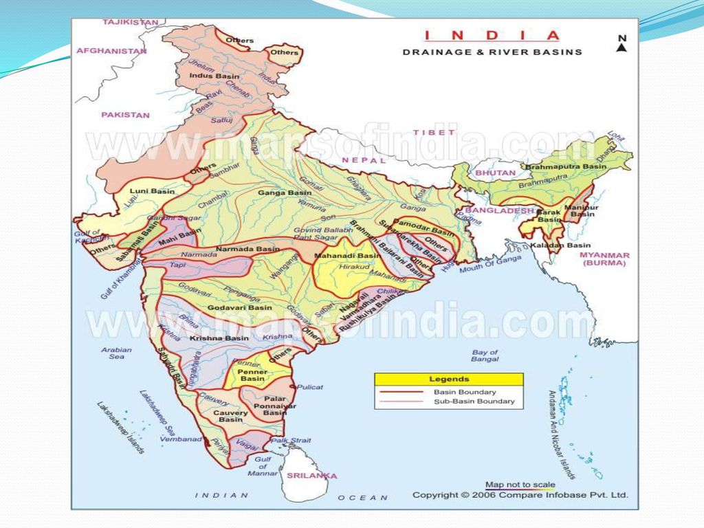
DRAINAGE RIVER SYSTEMS OF INDIA

3
Water divide IMPORTANT TERMS
Drainage basin: the area drained by a single river system i.e. main river and its tributaries. Water divide: elevated area or an upland that separates two drainage basin. Water divide

6
Drainage patterns Dendritic: forms when river follows the slope of the land ,river and its tributaries resembles the branches of the tree. Trellis: it develops over alternate band of hard and soft rocks (ridge and valley topography) tributaries join main river at approx. right angle. Rectangular : formed over hard and strongly jointed rocky terrain tributaries join main river at right angle. Radial: It develops when streams flow in different directions from a central peak or dome like structure.
 tributaries join main river at approx. right angle. Rectangular : formed over hard and strongly jointed rocky terrain tributaries join main river at right angle. Radial: It develops when streams flow in different directions from a central peak or dome like structure.")
7
River cycle and fluvial landforms
Features formed in youthful stage: v shape valley, waterfall alluvial fans Features formed in mature stage: meanders , ox bow lake , flood plains, levees Features formed in old stage: Delta , distributaries

8
Young stage Mature stage Old stage

9
Himalayan and peninsular rivers
Himalayan river 1.Perennial in nature 2.Source of origin -glaciers 3.Have long courses and perform intense erosion. 4.Mainly of dendritic pattern and forms well developed deltas. 5.Comparatively younger in origin. Peninsular river Non perennial in nature Source of origin lakes. Have shallower and shorter courses. Combination of dendritic, trellis and rectangular pattern . Show graded profile.

10
Himalayan river systems

11
s.no Name of the river Origin & drain into Tributaries remarks 1. Indus Near lake Mansarowar in Tibet Arabian sea Zaskas, Nubra , Shyok, Hunza in Kashmir region; Satluj ,Beas, Ravi,Chenab and Jhelum near Mithankot Emerges from mountain at Attock. Gentle slope Total length 2900km 2. Ganga Gangotri Glacier in Uttrakhand Bay of Bengal From Himalayan side-Yamuna,Ghaghara, Gandhak,Kosi From peninsula side-Chambal,Betwa,Son Formes the largest delta of the world along rivert Brahmaputra-Sunderban 3. Brahmaputra East of lake Mansarowar in Tibet Dibang, Dihang and Lohit Take u turn at Namcha Barwa to enter India

12
Indus Water Treaty : This treaty is about Sharing of the water of the River Indus between India and Pakistan. India can use 20% of the total water.

13
Ganga River System Headwater of River Ganga – Bhagirathi(origin Gangotri) and Alaknanda joins at Devaprayag to form Ganga At Haridwar emerge from mountains Northernmost point of Ganga delta-Farakka in W.Bengal Divide into Bhagirathi and Hoogly Mainstream flows southward joined by Brahmaputra and known as Meghna. Forms Sunderban delta named after sundari tree. Total length 2500km Ambala forms water divide between Indus and Ganga

14
Bramhmaputra river system
Also known as Tsang Po in Tibet and jamuna in Bangladesh Carries less silt in Tibet region and lagre amount of silt in Indian part Many problems are associated with it –floods, sedimentation of river bed and frequent shifting of its channel. Forms worlds largest riverine island- Majuli island in the state of Assam.

15
The Peninsular rivers

16
Peninsular River River Origin and drain into Tributaries Remark
Narmada Amarkantak hills in M.P Into Arabian sea Hiran, Kolar ,Tawa Forms Dhuan Dhar fall in Jabalpur (Marble Rock) Forms esturie Tapi Multai in Betul distt of M.P Purna,Betul,Amravati Called twin of River Narmada Mahanadi Dhandkaranya in Chhattisgarh Drains into Bay of Bengal Ib,Sheonath,Tel Hirakund Dam is built on this river It is the most important river of Peninsular River
 Forms esturie. Tapi. Multai in Betul distt of M.P. Purna,Betul,Amravati. Called twin of River Narmada. Mahanadi. Dhandkaranya. in Chhattisgarh. Drains into Bay of Bengal. Ib,Sheonath,Tel. Hirakund Dam is built on this river. It is the most important river of. Peninsular River.")
17
Peninsular River River Origin and drain into Tributaries Remark
Godavari Nasik district in Maharashtra Drain into Bay of Bengal Penganga,Wainganga, Indravati Longest river of peninsular India Also called Dakshin Ganga Forms Denderitic pattern Krishna Rises from The western ghats near Mahabaleshwar Drain into Bay of Bengal Koyna, Bhima,Ghataprabha, Tungabhadra,Musi Second largest river of peninsula Famous city of Hyderabad is located on the bank of River Musi one of the main tributary Cauvery (Kaveri) Rise in Brahmagri range of Western Ghates Amaravati and Shiva Main river for southern -most states Forms Delta Peninsular River
 Rise in Brahmagri range of Western Ghates. Amaravati and Shiva. Main river for southern -most states. Forms Delta. Peninsular River.")
18
Economic Benefits of river
Agricultural use, industrial use Hydro electricity production Formation of flood plains Inland transportation Water for domestic use

19
Lakes of India Classification on the basis of the origin:
Natural lakes-Glacial lakes (Dal lake),Lagoons(Pulicat lake),lakes formed due to inland drainage(Sambhar lake) Man made lakes-Nagarjuna Sagar, Nizam Sagar, Gobind sagar Importance of the lakes: Have moderating effect on nearby area, unique aquatic life, source of water for irrigation and other uses, eco tourism.
,Lagoons(Pulicat lake),lakes formed due to inland drainage(Sambhar lake) Man made lakes-Nagarjuna Sagar, Nizam Sagar, Gobind sagar. Importance of the lakes: Have moderating effect on nearby area, unique aquatic life, source of water for irrigation and other uses, eco tourism.")
Similar presentations


>")


