Download presentation
Presentation is loading. Please wait.

1
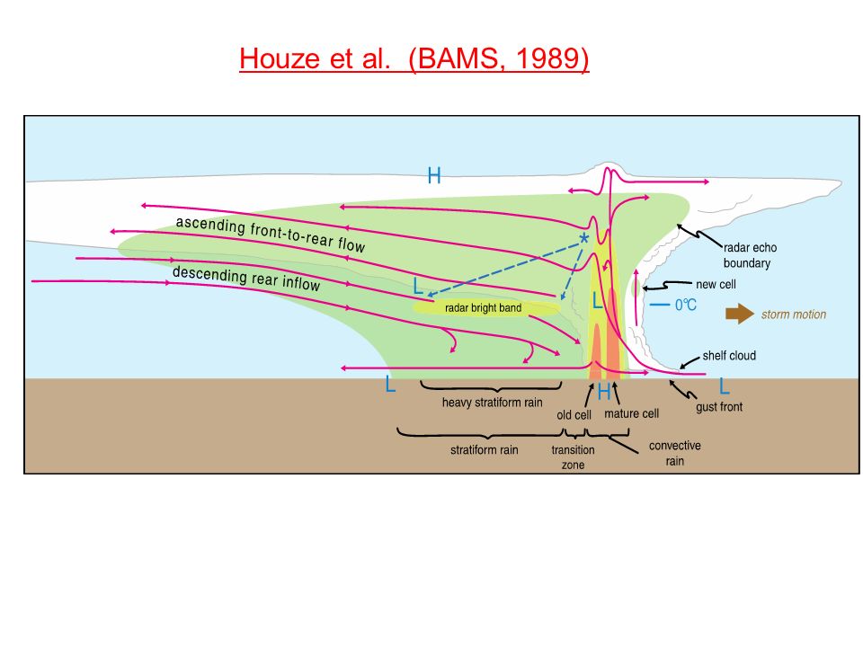
Houze et al. (BAMS, 1989)
")
3
Johnson and Hamilton (1988)
")
4
Basic Equations: 2D Squall Line - Or, more simply, consider the 2D horizontal vorticity equation: where ⁄ *Also, no vortex tilting or stretching

6
2D Convective System Evolution: C/∆u << 1C/∆u ~ 1C/∆u > 1 Weak shear, strong cold pool: rapid evolution Strong shear, weak cold pool: slow evolution

8
“Optimal” condition for cold pool lifting C/∆u > 1 C/∆u = 1 C/∆u < 1 RKW Theory Rotunno et al. (JAS, 1988)
.")
9
*Strength of Rear-Inflow Jet is proportional to CAPE Rear-Inflow Jets:

11
X Background and Definitions Mesoscale Convective System (MCS): an isolated, nearly contiguous region of thunderstorms, sometimes surrounded by an extensive region of moderate rainfall. Total size is usually 100-300 km across. Bow-echo: a bow-shaped line of thunderstorms often containing strong surface winds. Mesoscale Convective Vortex: a lower-mid- tropospheric horizontal wind circulation derived from an area of convection (often an MCS). 0600 UTC 10 June, 2003 11 June, 2003 0540 UTC 10 June, 2003 200 km
 UTC 10 June, June, UTC 10 June, km.")
12
Now Consider a 3D Squall Line….without Coriolis: - ⁄ ⁄

13
Weisman and Davis (1998) f=0
 f=0")
14
How can we systematically produce the observed line-end vortex pattern?

15
Mature Phase: Line-end vortex mechanisms:

16
Vortex Tube Circulation:

17
Vertical Vorticity: …flux form Circulation: ⁄ ⁄ ⁄

19
⁄ ⁄

20
(Davis and Weisman, 1994; Weisman and Davis, 1998; Davis and Galarneau, 2009) …tilting of system-generated horizontal vorticity Rear-inflow jet
 …tilting of system-generated horizontal vorticity Rear-inflow jet")
21
Role of Line-End Vortices Focuses and Intensifies Rear-Inflow Jet

23
Now Consider a 3D Squall Line….with Coriolis: -

24
⁄ f-flux

26
Derechos: Severe Lines of Thunderstorms Damage from straight-line wind Long swaths (> 400 km), long duration (> 6 h) Wide damage swaths (100-500 km) Rapid movement: 20-30 m/s 26 NOAA Storm Prediction Center Earthsky.org Csmonitor.com
, long duration (> 6 h) Wide damage swaths ( km) Rapid movement: m/s 26 NOAA Storm Prediction Center Earthsky.org Csmonitor.com")
27
Derecho: (Johns and Hirt 1987) Large CAPE Moderate Shear
 Large CAPE Moderate Shear")
29
29 June 2012 Derecho: 18 UTC21 UTC 00 UTC 03 UTC Composite Radar SPC Storm Reports

31
The 8 May 2009 “Super Derecho”: Morris Weisman NCAR/MMM Radar 17:56 UTC 05/08/09 (Paducah) Also: Lance Bosart, Clark Evans 8-10 h of Hurricane- Force Winds, Extensive Damage… SUNY Albany 9 April 2014
 Also: Lance Bosart, Clark Evans 8-10 h of Hurricane- Force Winds, Extensive Damage… SUNY Albany 9 April 2014")
32
11 UTC (23 h) 13 UTC (25 h)15 UTC (27 h) Occluding Stage: 09 UTC (21 h)
 13 UTC (25 h)15 UTC (27 h) Occluding Stage: 09 UTC (21 h)")
33
06 UTC 07 UTC09 UTC 11 UTC 12 UTC 13 UTC 850 mb W (contoured) and Vertical Vorticity (shaded)
 and Vertical Vorticity (shaded)")
34
Vorticity Equation: Vertical Vorticity: tiltingstretching

35
…Tilting…Stretching 850 hPa Vorticity 07 UTC

37
900 hPa Horizontal Vorticity, SR Flow, W (shaded) With low-level jet from SW, streamwise horizontal vorticity evident in low-level environment…. 08 May 2009 Derecho

38
29 June 2012 versus 08 May 2009 Derechoes 29 June 2012 …Cold-pool dominant …Descending rear- inflow …Cyclonic mid-level vortex 08 May 2009 …Mesovortex dominant …Elevated rear-inflow jet …Warm-core vortex extending to surface Radar Reflectivity Model Reflectivity

39
29 June 2012 08 May 2009 Cape/Shear Intercomparison: CAPE: 5000-6000 j/kg Shear: 20-30 kts (10-15 ms-1) CAPE: 2500-3500 j/kg Shear: 30-50 kts (15-25 ms-1)
 CAPE: j/kg Shear: kts (15-25 ms-1)")
40
29 June 2012 08 May 2009 850 hPa Intercomparison: Low-Level Jet, west-east boundary, Lee trough NO Low-Level Jet, NO west-east boundary

41
Summary: ….3 km WRF-ARW was capable of not only predicting the potential for two high-end Derecho events, but also was capable of distinguishing the differing mechanisms… 29 June 2012: Cold Pool dominant 08 May 2009: Mesovortex dominant ….These two cases may help clarify the differing environmental characteristics that contribute to these two archetypes: 29 June 2012: Extreme instability, modest unidirectional low-level shear 08 May 2009: Mid-trop baroclinicity, low- level jet, strong directional shear (streamwise at low-levels)
")
42
100-110KT winds at ~1kft Base Reflectivity 1334z KSGF

43
Storm-Relative Velocity 1334z KSGF

44
Atkins et al. MWR (2004)
")
46
Wakimoto et al. MWR (2006)
")
47
U S = 20/2.5 f=0 t = 4 hr 50 km w, V z=3 km qr, V θ’ z=250 m continuous updraft no meso- vortices!

48
U S = 20/2.5 t = 4 hr 50 km w, V z=3 km qr, V θ’ z=250 m locational bias

49
Vorticity Equation: Vertical Vorticity: tilting stretching …integrate along a parcel’s path:

50
⁄

51
Weisman and Trapp (2003)
")
56
Trapp and Weisman (2003)
")
58
Wakimoto et al. MWR (2006)
")
60
Example of a “Serial” MCV/MCS Case 0915 UTC 27 May 1998 0015 UTC 28 May 19980715 UTC 28 May 1998 2315 UTC 28 May 19980515 UTC 29 May 19981215 UTC 29 May 1998

61
IOP 1 200 km

62
IOP 8 900 hPa Widespread Instability m/s 70 60 50 40 30 20 10 dBz X 1730 UTC 11 June Mean Wind Profile

63
Potential Vorticity: = 0 for isentropic motions Equivalent Potential Vorticity:

65
Long-time Behavior of MCSs (twice) L H H Warm Cool
 L H H Warm Cool")
66
Raymond and Jiang (JAS 1990) Conceptual Model of Isentropic Lifting within a Steady Balanced Vortex (e.g., MCV)
 Conceptual Model of Isentropic Lifting within a Steady Balanced Vortex (e.g., MCV)")
67
MCV Induced Lifting and Destabilization Fritcsh et al. 1994, MWR

68
Low-Level Jet Scenario

69
Flash-Flood-Producing Convective Systems Associated with Mesoscale Convective Vortices Russ Schumacher and Richard Johnson WAF (2008)
")
Similar presentations


 that may contain a stratiform rain region.>")

 Lemon, L. R., and C. A. Doswell III, 1979: Severe thunderstorm evolution and mesoscyclone structure as related to tornadogenesis.>")


, chapter 10 Houze 1993: Cloud Dynamics,>")

 Chris Davis (NCAR ESSL/MMM and RAL) Stan Trier (NCAR ESSL/MMM) Boulder, Colorado 60-h Radar Composite Animation (00.>")


 Weisman, M. L., 1992: The role of convectively generated rear- inflow jets in the evolution of long-lived mesoconvective systems. J. Atmos.>")

